Box Hill Circular via Mickleham walk
A fairly strenuous walk in a beautiful part of the North Downs.

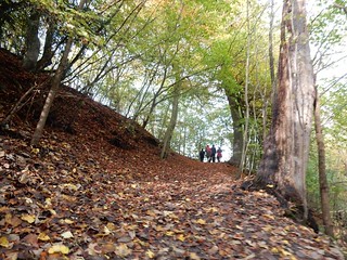
DSCF2055
Belted Galloway on Headley Heath
Oct-09 • Sean O'Neill
banner, swcwalk64, swcwalks 5446672349364852482 P

DSCF0632
Broadwood's Folly, Box Hill Country Park
Mar-09 • Sean O'Neill
swcwalk64, swcwalks, walkicon 5446672798182600210 P

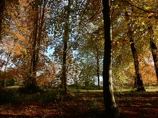
DSCF2033
View from White Hill
Oct-09 • Sean O'Neill
swcwalk64, swcwalks, walkicon 5446672706572174338 P


| Length |
Main Walk: 16¼ km (10.1 miles). Four hours 30 minutes walking time. For the whole excursion including trains, sights and meals, allow at least 9 hours. Short Walk 1, via Juniper Top: 13¾ km (8.5 miles). Three hours 40 minutes walking time. Short Walk 2, via Broadwood's Tower: 13¼ km (8.2 miles). Three hours 30 minutes walking time. |
|---|---|
| OS Map |
Explorer 146. Box Hill & Westhumble station is in Surrey, 2 km N of Dorking. |
| Toughness |
8 out of 10 (6 for the Short Walks). |
| Features |
Although they share the same station, this short but strenuous North Downs walk takes in a different area from the Westhumble Circular walk (2–14b). It traverses a series of hills in a clockwise loop north and east of Box Hill & Westhumble station: Norbury Park, Mickleham Downs, Headley Heath and finally Box Hill itself. There are many fine viewpoints and in several places you can see your earlier route from a new perspective. The area is deservedly popular and the famous sites are likely to be crowded on fine weekends, but there are quieter places in between. Norbury Park Nature Reserve is described by Surrey Wildlife Trust as a ‘working landscape’ which includes a sawmill and three farms. The prominent house at its centre (in private ownership) was built in 1774 and has had several famous owners and tenants, including Leopold Salomons (who donated Box Hill to the National Trust) and Dr Marie Stopes, the family planning pioneer. Box Hill (named for its abundant box trees) and Headley Heath are both owned by the National Trust, which has introduced special breeds of sheep and cattle to restore more of the downland to its original ‘unimproved’ condition. This unfertilized land is rich in wildflowers and supports many butterflies: 40 of the 58 British species have been found on Box Hill. You might come across areas grazed by sheep and cattle in Norbury Park, Headley Heath or Box Hill. Access through all these enclosures should still be possible but there could be temporary fences and gates (not mentioned in the text) to control the livestock. |
| Walk Options |
Two Short Walks replace the afternoon loop through Headley Heath with more direct routes through Box Hill Country Park. These have essentially been taken from the Box Hill to Leatherhead walk (1–49), although done here in the reverse direction. The first of these shorter walks climbs Juniper Top and loops around the top of the escarpment to rejoin the Main Walk at the Box Hill viewpoint. The second takes in a folly tower and for variety has a different ending, down long flights of steps to the famous Stepping Stones across the River Mole. All routes converge on the NT Visitor Centre and so in effect the two endings are interchangeable: the directions point out where you can switch between them. They also mention several short cuts which cut out some of the climbs, as well as detours to points of interest. |
| Additional Notes |
This walk originally had an option to finish in Dorking but it was hardly ever taken, even when there was only an hourly train service back from Box Hill (improved in 2019: see below). It has been replaced with the alternative ending mentioned above. A flaw in the original walk was that the lunch stop came too soon, so in 2019 the morning section in Norbury Park was extended with a 1½ km loop around Updown Wood on Fetcham Downs. The afternoon section of the Main Walk is still longer (and tougher) than the new morning route, but the lunch pub is now at the halfway point of the Short Walks. |
| Transport |
Box Hill & Westhumble is served by Southern trains from Victoria and South Western trains from Waterloo, both taking around 50-55 minutes. The off-peak service is hourly on both routes, except on Sunday afternoons when the Victoria service is half-hourly. An “Any Permitted” return to Box Hill & Westhumble is valid on both routes; a slightly cheaper “Southern Only” ticket is also available from central London. If you might want to divert into Dorking, note that a return to Dorking Stations is the same fare as Box Hill from London. If you want to abandon the walk after lunch, London bus 465 runs half-hourly through Mickleham on its route between Dorking and Kingston. Near the tea stop at the top of Box Hill, Metrobus 21 runs two-hourly (Mon–Sat) to Dorking or Leatherhead. If driving, there is a small free car park “for railway users” at Box Hill & Westhumble station and a larger one at Ryka's Café near the Burford Bridge roundabout, which you pass on the main return route. |
| Suggested Train |
Take the train nearest to 10:15 from Waterloo or Victoria to Box Hill & Westhumble. |
| Train Times |
|
| Timetables |
|
| River Levels |
|
| Lunch |
The suggested lunch place comes quite early in the walk, but you might still like to break for mid-morning refreshments at Wild!…About Coffee (07815-121471; usually open Thu–Sun), a pop-up café next to Norbury Park Sawmill. Mickleham (after 6½ km) has two possible lunch pubs, both fairly expensive. The suggested place is the King William Ⅳ (01372-372590; open Wed–Sun & BH Mon), hidden away on a path leading up to Mickleham Downs; it serves local beers and good home-cooked food and has an attractive terraced garden, but limited space inside. Just off the main route, the Running Horses (01372-372279) in Mickleham village is a good alternative. |
| Tea |
There is a popular café inside the National Trust Visitor Centre at the top of Box Hill, plus a servery offering hot and cold drinks, cakes and ice-creams. There is ample seating both inside and outdoors. The most convenient place near Box Hill station is the Stepping Stones (01306-889932) pub on Westhumble Street, passed on the way to the station and usually open all day. Another possibility is Ryka's Café (01306-884454; open to 4pm winter, 5pm summer), a popular spot for bikers which serves a wide range of food and drink. There used to be a shop and café in the station's Old Booking Hall, but Pilgrim Cycles closed in November 2022. |
| Profile | |
|---|---|
| Help Us! |
After the walk, please leave a comment, it really helps. Thanks! You can also upload photos to the SWC Group on Flickr (upload your photos) and videos to Youtube. This walk's tags are: |
| By Train |
Out (not a train station) Back (not a train station) |
| By Car |
Start RH5 6BT Map Directions |
| Amazon | |
| Help |
National Rail: 03457 48 49 50 • Traveline (bus times): 0871 200 22 33 (12p/min) • TFL (London) : 0343 222 1234 |
| Version |
Mar-24 Sean |
| Copyright | © Saturday Walkers Club. All Rights Reserved. No commercial use. No copying. No derivatives. Free with attribution for one time non-commercial use only. www.walkingclub.org.uk/site/license.shtml |

Walk Directions
Click the heading below to show/hide the walk route for the selected option(s).


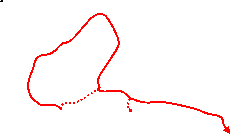
 Walk Map
©
Walk Options ( Main+ | Short )
Click on any option to show only the sections making up that route, or the heading above to show all sections.
- Main Walk (16¼ km)
Walk Directions
Click on any section heading to switch between detailed directions and an outline, or the heading above to switch all sections.
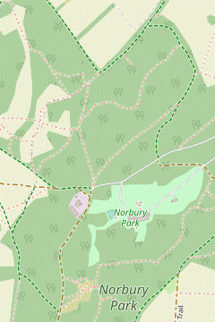
- Box Hill & Westhumble Station to Norbury Park Sawmill (2¾ km)
- Take the footpath heading north away from the station, then bear left across a large field (or keep ahead to reach the River Mole and turn left onto a permissive path along the riverbank). Go up through a wooded part of Norbury Park and turn right briefly onto a path along the woodland edge, then take a narrow path slanting uphill. Shortly after passing Druids Grove turn left up steps on a short zig-zag path to a viewpoint over the Mole Valley. Turn right onto a track behind the viewpoint to head north alongside the grounds of Norbury Park House to the sawmill.
- From the station car park, go up the concrete steps to the right of the footbridge between the platforms. These lead to a road where you turn left, crossing over the railway. On the other side of the bridge, immediately turn right onto a public footpath heading N, alongside the railway and leading into the corner of a large field.
-
Main route
- Bear left off the public footpath onto a permissive path going all the way along the left-hand edge of the field. On the far side go through a gate onto a broad woodland path, climbing gently at first and then more steeply.
- At the top veer left in front of the corner of a field, ignoring a fenced path ahead along its edge and joining the riverside route from a long flight of steps.
-
Riverside route (+175m)
- Keep ahead along the right-hand field edge, in 400m coming to a footbridge and railway bridge across the River Mole. Do not cross the river but instead turn left off the public footpath onto a permissive path along the riverbank.
-
You soon go over the first arm of an ox-bow lake?, now usually dry. The second arm is deeper, with steps on the grassy banks.
If this dip is flooded you will have to skirt around the entire ox-bow (or revert to the main route).
- At the end of the field go through a gate onto a narrow woodland path, still alongside the river. Where the river swings round to the right climb the long flight of steps in the wooded hillside ahead.
- You come out onto a path junction by the corner of a field. Keep ahead on a broad path alongside the field, ignoring a fenced path off to the right and joining the main route from the steep slope on the left.
-
The path goes up another short slope and comes to a T-junction. Turn right briefly onto another broad path, then in 60m turn left onto a narrow path winding gently uphill through the trees.
This path used to be signposted to Druids Grove, but the sign was missing when last checked.
-
For 200m the path stays fairly close to the broad path below, then veers left and climbs more steeply. In a further 175m there is a short flight of steps going up the slope on your left.
- For an easier route to the viewpoint and sawmill, climb the steps and turn right onto a track. You could simply follow this track for 1 km all the way to the sawmill (and resume the directions at §B), but it is worth forking right at a Viewpoint signpost after 500m and picking up the directions at [?].
- For the main route, follow the narrow and potentially slippery path for a further 650m as it contours along the wooded hillside. You go past clumps of box trees and several ancient yew trees, although nowhere along the path is actually identified as Druids Grove.
-
The turning off this path is easy to miss. At the start of a straight stretch lined with box trees veer left onto a zig-zag path of steps climbing up the wooded hillside. You emerge onto a viewpoint looking eastwards across the Mole valley to Mickleham Downs and Box Hill.
The prominent mansion away to the left is Cherkley Court, once the country estate of Lord Beaverbrook. The two open areas leading up Box Hill are Juniper Top and the Burford Spur.
- With your back to the view, bear right onto a path alongside the green chainlink fence of Norbury Park House, soon meeting a broad track. Turn right and follow this track alongside the security fence, heading N. In 400m you pass the entrance to Norbury Park Sawmill on your left.
- Norbury Park Sawmill to the Mickleham Bypass (3 km)
-
 Unless you want to take a short cut by following a bridleway along the sawmill's access road, fork left to head west to the edge of Fetcham Downs. Take a path on the right through Walnut Tree Clump and continue with a clockwise loop around Updown Wood, eventually heading south-west back towards the sawmill. Fork left onto a path joining the bridleway where it leaves the access road. Head east on this bridleway, initially alongside the grounds of Norbury Park House and then downhill to a lane. Turn right to cross the River Mole and then the A24 (Mickleham bypass).
-
After passing the sawmill entrance the track forks in front of a triangular area with an information panel about the history of Norbury Park (and sometimes a pop-up café, Wild!…About Coffee).
- If you want to cut out the loop around Updown Wood (saving 1½ km) keep right to continue on the sawmill's access road. After passing a security gate for Norbury Park House and descending for 175m, turn right onto a signposted public bridleway and resume the directions at [?].
-
For the main route fork left in front of the triangular area onto a broad track heading W. In 125m fork right where the track splits to go along the edge of an open area, part of Fetcham Downs.
- In 125m turn right onto the second of two paths into the trees, going past a vehicle barrier. This leads into a semi-open grazing area with scattered trees and shrubs (Walnut Tree Clump), with a clear grassy path ahead.
- In 300m keep ahead at a path crossing. The path curves right, then goes into a more wooded area with a fenced enclosure on the right. Follow the path out past another vehicle barrier to a T-junction with a broad track.
- Turn left onto this track, heading NE and soon coming to a corner of the wood with views across the downland to Leatherhead in the Mole valley. Stay on the main track as it heads NE along the edge of the wood, passing a “Woodland Management” information panel.
- In 300m (with more views to the left, and a post marked 15 Z) follow the main track round to the right to head E, soon bending right again to head SE. After going in this direction for 200m the path bends right again to head SW and merges with another path coming up from the left.
- In a further 100m fork left by another marker post (4 M). In 150m this path veers left to go down and across a dip and emerges onto the tarmac lane from the sawmill. Go across this (slightly to the right) onto a signposted public bridleway.
-
Follow the bridleway up a slope, alongside the security fence of Norbury Park House again. In 200m you pass a gate into the grounds and bear right, ignoring the (seemingly unused) driveway down to the left. At the next path junction there is a sign pointing right to Centenary Copse & Viewpoint.
- If you wish you could make a short out-and-back detour to this viewpoint, a small terrace with a wooden bench 100m away.
- For the main route fork left at the signpost and follow the bridleway downhill through the trees to an open area by a communications mast, with views across the valley to Cherkley Court.
- Carry on downhill, later on a broad grassy strip alongside the driveway you crossed earlier and then the tarmac lane from the sawmill, which both merge from the left. Where the lane swings off to the left keep right on a path between hedges.
-
Follow the path down to a lane and turn right. After crossing the River Mole the lane comes to the A24 (Mickleham bypass) opposite its junction with Old London Road. Cross this busy dual carriageway with great care, to the left of the junction.
- The Mickleham Bypass to The Gallops (1¾ • 2¼ km)
-
 The main route is along a footpath behind the houses alongside the A24, but to visit the Running Horses follow Old London Road to the pub and return via a footpath through the churchyard. At the end of the footpath parallel to the A24 continue along School Lane and Byttom Hill. Take the path up past the King William Ⅳ pub and turn left onto a broad level path. At the end turn right onto a footpath climbing steadily up Mickleham Downs. At the top turn half-left onto a bridleway which leads to the middle of a long open area, The Gallops.
-
Main route
- On the other side of the A24, turn left along the pavement for a short distance. At the end of a high brick wall in front of the first house, turn right into a driveway (as indicated by a bridleway signpost on the other side of the carriageway).
- In 40m, where the drive swings round to the left at Old House Cottage, keep ahead along a path. 30m later, follow it round to the left at a path junction.
-
Alternative route (+500m)
- Go along Old London Road for 250m to reach the Running Horses pub? on your right, opposite the churchyard.
- To resume the walk, go through the churchyard and turn left onto a grassy path 40m behind St Michael's church?. Follow this footpath out of the churchyard, straight ahead across Dell Close, then turn right at a path T-junction.
- Head E along the path, between hedges. Ignore footpaths on either side of a recreation ground on the right and continue on a tarmac lane (School Lane). This curves round to the left, passes St Michael's School and comes to Byttom Hill. Turn right onto this unsurfaced lane, away from the A24, then in 40m turn right up a flight of steps to reach the entrance to the King William Ⅳ pub.
-
The walk continues up the the narrow path past the pub to a crosspaths, where you turn sharp left onto a broad level path flanked by low brick and flint walls, with views across the valley. In 200m, just before the path meets a lane, turn right through a gap to the right of a metal fieldgate onto a signposted footpath.
- Follow the path for 600m as it climbs steadily up the wooded Mickleham Downs, later with a wire fence on the left. At the top of the hill turn half-left to stay alongside the fence, now heading E on a bridleway.
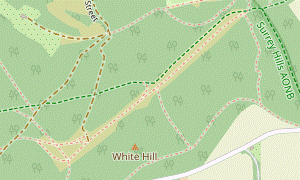
- Continue in this direction for 450m, crossing a couple of chalky tracks along the way. Eventually the bridleway swings right and emerges onto the middle of The Gallops?, a 1 km long strip of open grassland.
- The Gallops to Headley Heath (1½ km)
- Head north-east along The Gallops. Near the far end veer right onto a path going down the side of White Hill to Cockshott Cottage. Cross Headley Lane and continue on a bridleway up the other side of the valley to Headley Heath.
-
For the Main Walk turn left to head NE along The Gallops. The next turning is easy to miss. For the best route down the steeply wooded hillside on your right, veer right onto an unmarked path into the trees at the end of the open area, ignoring the NT “Box Hill Hike” waymarker pointing straight on.
- If you miss this path you could follow the waymarkers and turn right onto a signposted bridleway 60m ahead; this route is slightly shorter but drops down very steeply near the bottom of the hill.
-
On the suggested route the narrow path soon broadens as it winds its way down the side of White Hill, less precipitously than the bridleway. At the bottom turn left onto a well-defined path near the edge of the wood, heading SE. In 200m continue through Cockshott Wood car park, meeting the bridleway from The Gallops at the far end.
After this small variation the route now follows the waymarked “Box Hill Hike” all the way to Box Hill.
- Headley Lane is popular with speedy cyclists so take care as you cross it. Take the bridleway to the left of Cockshott Cottage, which bends left and goes uphill between trees and a wire fence.
- At the top the bridleway levels out and bears right to go alongside a brick buttress supporting a tarmac lane on the right, the access road for High Ashurst (Outdoor Education Centre). Ignore an awkward bridleway going steeply downhill to the left and continue parallel to the lane for 40m, then turn left through a wooden side gate onto Headley Heath.
- Across Headley Heath (2 km)
-
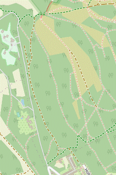 There are many possible routes across Headley Heath. The suggested route takes you up an open spur with fine views, then into a more wooded area. At a major path junction, turn half-right onto a narrow path which later joins a bridleway leading out of the heath in its south-western corner.
-
Go downhill on a broad stony track, which in 150m comes to a path junction.
- If you want to take a direct route through Headley Heath, fork right uphill and follow this woodland track near its western edge. In 900m (having ignored several turnings off to the lane), veer right where the path forks and keep right at the next junction to come to a small car park at a corner of the heath. If you take this short cut, resume the directions at §F.
- For the suggested route turn sharp left at the junction. Follow the track for 250m, at first downhill and then curving round to the right. Just before it starts to climb a short way ahead, turn right up a flight of steps cut into the grassy bank.
- Continue on a broad grassy path up an open spur, with increasingly fine views of the heath and back across the valley to White Hill. Follow the main path for nearly 1 km, later through a more wooded area, to a six-way path junction in a small clearing.
- Take the second path on the right, turning half-right from your previous direction to head SW. In 125m keep ahead at a path crossing, after which the path narrows and winds downhill. In 125m go past a wooden horse barrier and straight across a staggered path junction, joining a bridleway coming in from the left at a hairpin bend.
-
The stony track goes down across a small dip and curves to the right up the other side. A track merges from the left and you fork left at the next junction. In a further 150m you come to a small car park at the south-western corner of the heath.
- Headley Heath to Box Hill Visitor Centre (3¼ km)
- Head south down Headley Heath Approach and cross Box Hill Road onto a bridleway which merges with the North Downs Way (NDW) above the old Brockham Lime Works. Follow this downhill for 200m and then go up a flight of steps on the right. At the top fork left off the NDW onto a track gradually descending along the side of the downs, with fine views to the south. After skirting a house “Boxhurst” turn sharp right onto a track leading into Box Hill Country Park. Take any of the grassy paths going steeply uphill to the famous viewpoint. From the Salomons Memorial take the path alongside Zig Zag Road to the Visitor Centre.
- Go through the car park and turn left onto a lane. Take the right fork (almost straight on) and follow this lane S past houses for 750m to Box Hill Road.
- Cross over and continue on the bridleway opposite, in a belt of trees. In 200m the path starts to descend and shortly afterwards merges with the North Downs Way? (NDW) above the steeply wooded site of the old Brockham Quarry and Lime Works?.
-
After going steeply downhill for 200m turn right up a flight of steps with a wooden handrail, staying on the NDW. At the top the path forks.
- If you want to take a less strenuous route to the Box Hill viewpoint, fork right and follow the NDW signs for 1½ km, at first through woods and then on a path close to Zig Zag Road, to reach the viewpoint. If you take this short cut, resume the directions at [?].
- For the main route fork left (leaving the NDW) and follow this permissive path gently downhill, with extensive views to the south (the village below is Brockham). In 300m you go over a stile by a gate and along the southern edge of Box Hill Country Park for the next 800m, eventually leaving it through a wooden gate.
- Just before the track comes to a metal fieldgate in front of a private property, veer left as indicated down a narrow fenced path alongside a large field. This leads into a driveway which you follow downhill for 50m, then turn sharp right onto a track to start going back uphill. In 100m keep left to go through a wooden gate, re-entering the Country Park.
-
For the walk's final climb follow the main path up to the right. After going through a small wooden gate the most direct route is to veer right onto one of the broad grassy paths climbing very steeply uphill to the famous viewpoint at the Salomons Memorial?.
- For an easier climb you could carry straight on and eventually turn sharp right at a path junction (almost doubling back) to reach the viewpoint.
- Turn left onto the tarmac path behind the viewpoint, which curves round to the right and goes alongside Zig Zag Road to reach a large picnic area in front of a couple of buildings. The NT Café is at the back of the Gift Shop in the first building, with a Servery for light refreshments in the second.
- The Gallops to Box Hill Country Park (1¼ km)
-
 Head south-west along The Gallops. Near the far end fork left onto a narrow path into the trees, which leads to a footpath going steeply down White Hill. Cross Headley Lane and go through Whitehill car park, entering Box Hill Country Park.
-
For the Short Walks turn right to head SW along The Gallops. In 300m keep to the left of a clump of trees, where there is an “Archaeology on Mickleham Downs” information panel. Just before the end of the open area, fork left onto a grassy path into the trees.
-
Follow this winding path for 250m, still heading roughly SW. 25m after passing a prominent beech tree, keep left at a little triangle of paths to end up on a broad path heading SE. This soon turns right and comes out into the open, with a fine view across the valley to Juniper Top in the main part of Box Hill Country Park.
You are now following the route of Walk 1–49 (in reverse).
- Continue on the path, heading SW down White Hill. In 150m it bends left and goes steeply down a long flight of steps. At the bottom Headley Lane is popular with speedy cyclists as well as cars so take care as you cross it.
- Go through Whitehill car park onto a track into Box Hill Country Park. In 30m there is a fieldgate on the left and a choice of routes.
- The Country Park to the Visitor Centre via Juniper Top (3 km)
- Inside the Country Park fork left onto a path climbing steadily up Juniper Top. Continue along a woodland track heading south to Flint Hill, then turn left onto a bridleway and follow this out to Zig Zag Road. Turn right to go along the roadside path for 150m, then veer left to join first the NDW and then a permissive path along the open downland …
- Fork left off the main track, going through a wooden side gate. Go uphill on this path, which soon opens out into a broad grassy area with increasingly fine views behind you as you climb.
- Where the grassy path levels out at the top, keep right. In the top right-hand corner go through a wooden side gate next to a fieldgate onto a track. Follow the main track S for 800m, ignoring several turnings to the left.
- The track eventually comes to a Y-junction, with a blue-topped bridleway post on the right. Fork left, then in 25m turn left at a path crossing onto the bridleway coming up from Juniper Bottom, joining the NT's Happy Valley Walk.
- The bridleway gradually curves round to the right. In 300m there is a boundary fence on the left and the path eventually comes out onto a lane (Zig Zag Road), with a Smith & Western restaurant ahead. Cross the road and turn right onto the roadside path.
- Although you could simply follow this path to the viewpoint, the suggested route is to turn left after 150m, at a footpath signpost by the 30mph road signs. Follow the short path through the trees and turn right at a T-junction onto the waymarked North Downs Way? (NDW), parallel to the road again. The path soon goes through a gate onto an open stretch of downland, with a fine view to the left.
- Once again you could simply stay on this path, but the suggested route is to veer left after 75m onto a grassy path slanting down the hillside (where another link path comes in from the right, and 50m before the NDW goes back into the trees through another gate).
- The path merges with a chalky path and levels out. In around 200m it goes through a gate in the tree boundary ahead, merges with the NDW from the right and comes to the famous viewpoint at the Salomons Memorial?.
- …
- The Country Park to the Visitor Centre via Broadwood's Tower (2 km)
- Inside the Country Park go along Juniper Bottom for 250m and then turn right onto a path climbing steeply up the wooded hillside to Broadwood's Tower. Continue along a woodland path heading south-east and then south through the Country Park. Follow the path round to the right in front of Donkey Green and go past the NT car park to the Visitor Centre.
- Ignore the path up to the left and continue on the main track, along Juniper Bottom. In 250m it goes through a gate into a more open area. Veer right onto a chalky path climbing steeply up the open hillside, with a flight of steps cut into the grassy bank for part of the way.
- At the top go through a gate into woodland. After a short final climb turn right at a T-junction and follow the path round to the left. Immediately after a path joins from the right, fork right at a Y-junction. In 100m you come to a circular brick folly, Broadwood's Tower?.
- Turn left at the tower to go gently uphill on a track, heading SE. Soon there are views on the right across a valley to the Burford Spur. Stay on this woodland track for 1 km, gradually curving to the right to head S.
- As you approach an open space (Donkey Green) follow the track round to the right to pass it on your left. Skirt around or cut through the NT car park and cross a lane (Zig Zag Road) to reach a large picnic area in front of a couple of buildings. The NT Café is at the back of the Gift Shop in the left-hand building, with a Servery for light refreshments in the other.
- The Visitor Centre to Box Hill & Westhumble Station via Burford Meadow (2½ km)
-
-
To go via the Salomons Memorial, head south-east alongside Zig Zag Road to reach the famous viewpoint. Turn right onto the NDW to come to the top of a long flight of steps.
- To switch to the Burford Spur ending turn right onto a footpath along the top of the hillside and pick up the directions in §K.
- To bypass the Salomons Memorial, take the path towards Swiss Cottage and turn right in front of its entrance. At a T-junction turn left to come to the NDW at the top of the steps.
-
To go via the Salomons Memorial, head south-east alongside Zig Zag Road to reach the famous viewpoint. Turn right onto the NDW to come to the top of a long flight of steps.
-
Route via Salomons Memorial
- Turn right out of the buildings and take the tarmac path heading SE alongside Zig Zag Road to reach the famous viewpoint at the Salomons Memorial?.
- Go down a few steps beside the memorial and turn right onto a path, joining the North Downs Way? (NDW). In 150m go through a gate, where another footpath merges from the left.
- In 50m go through another gate at the top of a long flight of steps (the continuation of the main route), with another path branching off to the right.
- If you want to switch to the Burford Spur ending fork right onto the side path, leaving the NDW. In 200m ignore a path on the right leading back to the Visitor Centre. Shortly after passing a headstone for Major Peter Labellière? keep ahead where a path joins from the right and resume the directions at [?] in §K.
-
Route bypassing Memorial
- Take the path from the left-hand end of the NT Café towards Swiss Cottage?. Turn right in front of its entrance onto a woodland path heading W.
- In 125m turn sharp left at a T-junction and follow the chalky path gently downhill for 200m to meet the NDW at the top of a long flight of steps.
- Follow the NDW all the way down the wooded hillside, on several long flights of steps. At the bottom the path forks and a concrete waymarker offers a choice of Stepping Stones (left) and Footbridge (right).
- The onward route continues from the other side of the footbridge but the suggested route is to fork left to see the famous Stepping Stones?. When you reach the river you can decide whether to risk crossing it there; at some times it is simply not possible.
- Whether you have braved the stones or not, turn right (leaving the NDW) and follow the river downstream for 150m to reach the footbridge. If you have not already done so, cross the river and turn right; otherwise simply carry on past the bridge.
- The route continues on a permissive path through Burford Meadow, following the course of the tree-lined river as it curves left below the steeply wooded hillside of The Whites. At the far end go up a small bank onto a footway in front of the A24.
- Unless you want to detour to Ryka's Café (250m off to the right, in the large public car park beyond the roundabout and hotel car park) go down a subway ramp and under this busy main road. On the other side go up the ramp on the left to a road junction and turn right into Westhumble Street.
- You soon reach the Stepping Stones pub on the left, a convenient refreshment stop. The station is a further 300m along this narrow street, but there is a pavement or a footway on one side or the other. Before the road rises to cross the railway bridge, bear left into the station car park. Cross the station footbridge to Platform 1 for trains to London.
- The Visitor Centre to Box Hill & Westhumble Station via the Burford Spur (2 km)
- Go past the old fort behind the Servery and through a belt of trees. Turn right onto the clifftop path above The Whites and continue down the Burford Spur, at some point veering left to come out onto Old London Road. Turn left to go past the Burford Bridge Hotel and continue alongside the A24, crossing the River Mole on Burford Bridge. …
- Go around the side of the Servery and cut through a small car park to the old Box Hill Fort?. Continue past its right-hand side and veer left through an opening in the stone wall. Go over the grass rampart onto a short path through the belt of trees ahead and turn right at a T-junction.
-
Follow the chalky path along the top of the steeply wooded hillside of The Whites, with a fine view across the ‘Mole Gap’.
In the valley is the large expanse of Denbies Vineyard, with the village of Westhumble to its right and the wooded Ranmore Common beyond.
-
After going through a wooden fieldgate the downland opens up and the descent becomes steeper. The most direct route down the Burford Spur is to keep left, aiming to come out onto Old London Road not too far from the prominent roundabout on the A24.
- For a less precipitous descent you could carry straight on and then double back to meet the road a little further along.
- Unless you want to visit Ryka's Café (in the large public car park across the road) turn left, passing the Burford Bridge Hotel. After crossing the River Mole on a footway alongside the A24 …
- …
- An ox-bow lake is a shallow horseshoe-shaped depression on the floodplain beside a river, formed when one of its meanders has been cut off. This one is usually dry but occasionally floods when the second of its two inlets is breached.
- The Running Horses pub was renamed after the two horses which tied in the “Dead Heat Derby” of 1828, Colonel and Cadland. They are pictured on opposite sides of the inn sign.
- St Michael, Mickleham dates from Saxon and Norman times but most of the original features were lost in an 1842 renovation. It has a ‘weeping chancel’, one which is out of alignment with the nave.
- As the name implies, The Gallops was used for leisure riding and for exercising horses racing at Epsom (which were stabled at the Running Horses pub in Mickleham).
- The North Downs Way runs for 246 km along the length of the North Downs (with two sections at its eastern end), from Farnham in Surrey to Dover in Kent.
- Brockham Quarry and Lime Works was a major industrial site in Victorian times. Chalk was extracted from the quarry until 1936 and burnt in kilns to produce quicklime, used in the manufacture of mortar and fertiliser.
- The Salomons Memorial commemorates Leopold Salomons of Norbury Park, who bought Box Hill when it was offered for sale in 1912 and donated it to the National Trust two years later.
- Broadwood's Tower was built in the 19thC by the piano manufacturer Thomas Broadwood, who owned the prominent house in the valley below, Juniper Hall. An ailing holm oak growing inside it had to be removed because it was damaging the structure.
- Major Peter Labellière was an eccentric local resident who insisted on being buried upside down, reasoning that “as the world is turned topsy-turvy” he would be the right way up in the end.
- The television pioneer John Logie Baird lived in Swiss Cottage from 1929–32 and conducted some of his early experiments there.
- The Stepping Stones might have been installed by a 19thC landowner to facilitate access to his orchard on the level ground at the foot of Box Hill. The current stones were laid in 1946, the originals having been destroyed in World War Ⅱ as an anti-invasion measure.
- Box Hill Fort was one of a chain of mobilisation centres built to defend London at the end of the 19thC, but the idea was soon abandoned. It has now been colonized by several species of bats.
There is a choice of routes across this field to the wooded part of Norbury Park. The more attractive riverside route in [?] is best avoided in winter or after heavy rain, as it crosses an inlet of the river which might be flooded.
If you are going to the alternative lunchtime pub (the Running Horses) or want to visit Mickleham church, follow the directions in [?].
If you are doing one of the Short Walks (omitting Headley Heath), go to §G.
Complete the directions at §K, or [?] in §J if you want to switch to the alternative ending via Burford Meadow.
If you are doing Short Walk 2 (via Broadwood's Tower), go to §I.
…
If you are switching endings and have already been to the Salomons Memorial, take the alternative route in [?].
Walk Notes
» Last updated: March 21, 2024
Return to Top | Walk Map | Walk Options | Walk Directions.