Burgess Hill to Hassocks walk
A long almost circular walk via the Sussex Border Path, Sussex Villages, and the South Downs Way ridge from Ditchling Beacon to Wolstonbury Hill

Burgess Hill to Hassocks
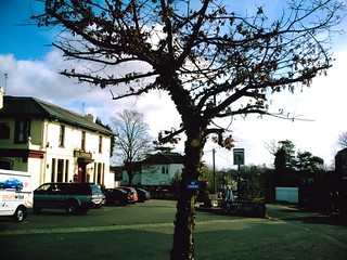
View of water tower from path over railway near Burgess Hill. D.Allen Vivitar 5199 5mp
Jan-06 • magyardave2002 on Flickr
watertower book3 swcwalks walk108 907335245

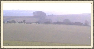
South Downs from Park Barn Farm on the Sussex Border Path on the Burgess Hill to Hassocks (extra) walk 108
Mud to die for on the SBP between Ditchling & the South Downs. D. Allen Vivitar 5199 3 March 2007
Jan-06 • magyardave2002 on Flickr
england sussex book3 swcwalks walk108 411656390
The Hassocks PH
Hassocks, West Sussex
Jun-06 • magyardave2002 on Flickr
book3 hassocks swcwalks walk108 12950326944
Burgess Hill to Hassocks - Sussex Border Path
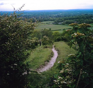
View from top of the South Downs towards Indian War Memorial (just over the horizon as you follow the line of trees along the Sussex Border Path). D.Allen Vivitar 5mp
Jun-06 • magyardave2002 on Flickr
downs sussex sbp book3 swcwalks walk108 414103885

Saturday Walkers Club Book 3 (extra) walk 108 - Burgess Hill to Hassocks: The Bull Inn & The Post Office Ditchling Sussex
The Sussex Border Path is an integral part of the Burgess Hill to Hassocks walk (via the South Downs) that goes through the charming village of Ditchling. As of May 2015 the building far left on the corner is now a cafe! D.Allen Vivitar 5mp
Mar-07 • magyardave2002 on Flickr
sussex bull book3 ditchling swcwalks walk108 414103881
South Downs ascent
It's That Man Again! Ascending the South Downs on the Sussex Border Path near Ditchling Beacon. Photo By D.Allen Vivitar 5 mp
May-07 • magyardave2002 on Flickr
book3 swcwalks walk108 502463293
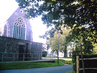
Hurstpierpoint
Hurstpierpoint College and Chapel West Sussex. D.Allen vivitar 5199mp
Jul-07 • magyardave2002 on Flickr
college sussex book3 hurstpierpoint swcwalks walk108 1751118345
| Length |
26.7km (16.8miles) approximately. For a shorter walk, see Walk options below Time: 7 hours. For the whole outing including trains, sights and meals allow at least 11 hours. |
|---|---|
| OS Maps | OS Landranger Map: 198 OS Explorer Map: OL11
Burgess Hill, W.Sussex, GR TQ317188; Hassocks, W.Sussex, GR TQ304155 |
| Toughness |
8 out of 10 (less for the shorter options) |
| Walk Notes |
This walk takes in Sussex landmarks including three windmills, two golf courses, ponds, a water tower, picturesque villages and The Sussex Downs with panoramic views of surrounding countryside and the South coast. Initially following the railway track south towards Hassocks, the walk goes east through a local rural park area and climbs up to a distinctive water tower visible for miles around. Continuing on with constant views of the Downs to the south, passing stables, farms etc, it joins the Sussex Border Path, which divides east and west Sussex, and travels south towards Ditchling (the recommended lunch stop for the short walk, and a possible early lunch stop for the main walk). Later, the path steeply ascends near Ditchling Beacon. After a descent for lunch at the Plough at Pyecombe, there is a gentler climb up Wolstonbury Hill. There follows a descent to Hurstpierpoint (and its College); the route almost coming full circle -just skirting Burgess Hill on the way to Hassocks. |
| Walk Options |
The walk can be shortened by;
|
| Travel |
Trains go from London Victoria or from London Bridge to Burgess Hill (some involving a change at East Croydon) on the Brighton line; journey time, just over an hour. Trains back to London from Hassocks are around three an hour on Saturdays and also on Sundays. Trains back from Hassocks are 3 per hour; there is a pub right by the station. Suggested train: Take the train nearest to 08.45 from Victoria to Hassocks - or London Bridge (change at East Croydon 09.07). Trains usually every 30 mins. CDR to Hassocks approx. £11 with a Network card. For those driving, park at either Burgess Hill or Hassocks; stations are only 4 minutes apart by train but check train times and parking costs. |
| Lunch |
|
| Tea |
|
| Profile | |
|---|---|
| Help Us! |
After the walk, please leave a comment, it really helps. Thanks! You can also upload photos to the SWC Group on Flickr (upload your photos) and videos to Youtube. This walk's tags are: |
| By Train |
Out (not a train station) Back (not a train station) |
| By Car |
Start RH15 9DG Map Directions Return to the start: Finish BN6 8JD Map Directions Travel to the start: |
| Amazon | |
| Help |
National Rail: 03457 48 49 50 • Traveline (bus times): 0871 200 22 33 (12p/min) • TFL (London) : 0343 222 1234 |
| Version |
Apr-24 David Allen |
| Copyright | © Saturday Walkers Club. All Rights Reserved. No commercial use. No copying. No derivatives. Free with attribution for one time non-commercial use only. www.walkingclub.org.uk/site/license.shtml |


Walk Directions
- [1] GR 317188. Coming off the Burgess Hill Station Southbound platform, go through the recently erected ticket barrier into the carpark and walk diagonally right towards footpath sign. (Should exit be closed off, ascend stairs to emerge through booking hall on road bridge where you turn right and immediately right again to descend steeply to aforementioned car park with the platform to your right).
- Follow footpath, and later on a bridleway, south-southwest, parallel to the railway, a housing estate to your left at first, for 1km without deviating until you reach a new 4-armed metal footpath/bridleway signpost (where the bridleway turns right along a gravel car wide track and crosses a bridge over the railway).
- [2] GR 312177 Turn left to immediately go through a kissing gate to the right of a gate. Follow a clear path across a public field with benches, your direction southeast (140°); a white water tower 400m away, just to the left. After descending for 200m through a row of recently planted trees, cross a footbridge over a stream and on through a hedge to ascend on a bearing of 130°, passing a lone oak tree. After 150m go through a gap in a hedge to continue up for another 70m aiming for the corner of the field and the line of trees to the right, at about the same height as the water tower to your left). Go through the kissing gate by public footpath signs and turn left to follow what is actually the tarmaced driveway of Weald House eastwards for 150m. Cross the road (that leads into Burgess Hill) and turn right to continue for 10m (only). Turn left along Wellhouse Lane. Follow this eastwards for 450m until you reach Wellhouse Farm. At a footpath sign veer right onto the grass. (Do not go down paths to Old Barn or Well Cottage!) Follow footpath South eastwards without deviation for 800m, crossing several streams and stiles and following a farm track past stables until you reach the B2112. (Note: should you feel the need, turn right to find a garden centre 150m approximately, along the road with tea/toilet facilities!)
- Turn left after crossing the road and walk 60m along a grass verge alongside the fences of houses until you reach the edge of a garden with a stream and a hedge beyond it. Turn right through a metal gate into a field and go diagonally left on a bearing of 60° for 460m uphill (towards the furthest visible tree on the left of a line of trees in the distance) which will lead to a railway bridge with a broken gate and stile at the top of the field, likely to be very muddy as it's a cattle crossing.
- [3] GR 336175 Do not cross bridge! You've now reached the Sussex Border Path (SBP) although there's no visible indication! Turn right and follow it South east, your bearing 150° initially, keeping the fences and hedges of aptly named Clearview Farm to your left to wheel south until you get to the bottom lower corner of the field. Cross the (Monday Group) stile. In 7m fork right to cross a second stile and a two plank bridge. Stay on the path to the right, keeping fairly close to any fields to the right, if not actually in the field. (The parallel footpath on your left whilst appearing attractive as it has Monday Group stiles, eventually merges with muddy streams!) Try not to deviate off into all sorts of dead ends or private property all the way to Ditchling for about 2.5km with the South Downs clearly visible in the distance.
- In detail; cross several stiles (some delapidated, others dog-friendly) and stream crossings following a line of neglected woodland and rough pasture. Parts of the pathway are enclosed. Then you pass a house with a pretty pond to the right. Ignore a blue arrow going left at a stream by an oak tree! (It leads to the parallel path and is very muddy!) Just after that you pass Fourfields free-range chicken farm. Just after that, cross a stile by the bend in the farm road to continue on for 30m then go over a stile to your right to cross a horsey field diagonally on a bearing of 235°.After 110m go over a stile and follow the hedge to your left for 75m. Cross a stile into the next field and turn right following the yellow footpath sign arrow. After just 20m cross a stile to continue along a tarmac path by Dicul Cottage for 40m until you reach a junction of old lanes with houses and cottages. Follow "The Dymocks" for 100m until you reach a minor road. Cross, to continue straight on along a tarmaced alleyway called "The Twitten", sign-posted The Old Meeting House (Unitarian), the graveyard of which you soon pass. In 120m turn right along a main road to almost immediately reach The Bull on your right hand side.
- [4] GR 326 152 At the crossroads turn left down South Street (B2112). Continue for 120m until you reach the junction of Clayton Road and Beacon Road. Cross there to a grass verge with a white 3-armed signpost. To the left of a public bench is a footpath sign for the Downs. Go along the enclosed pathway for 200m until you emerge by a small housing estate mini-roundabout. A sign in the middle points right. Follow this to go right between houses to cross a stile, a narrow grassy area followed by a footbridge and wooden gate to emerge into a field. Walk diagonally left southwest, 225° initially to a gap in the first hedge by an oak tree (after 140m). Having passed through gap, bear left southwards (180°) to go straight across the field towards woods ahead with a hedge to its right. In 200m pass an arrow marker on a post to go through a gap in the hedge. Carry on in the same direction for 300m alongside a hedge to your left until you reach a gate which you go through. In 75m pass Park Barn Farm, usually muddy and full of horses, to follow a recently fenced-in path by a line of trees to your right, bearing 220°. At the corner of the field in 230m cross a stile and turn right along a lane. After 120m turn left down an unsignposted public footpath or bridleway (continuation of the SBP). Follow this SSW and upwards for 1300m, initially through a gully until you clear the treeline to continue the gruelling uphill slog following first one then two extremely well defined chalky tracks. Coombe Bottom is to your right. The area at the top of the climb is known as Burnhouse Bostall.
- [5] GR 315129 Once at the top, near spot height 234, (Ditchling Beacon is to the left) either go through the gate in fence ahead or turn right to head for and reach a major path junction with a four-armed signpost having gone through a gate. The South Downs Way goes from left to right; go right and follow it west for 50m until you reach a signpost with a (bridleway) blue arrow. Turn left here through a gate to continue southwest along the SBP keeping a fence to your right initially for 1.25km until you reach the SECOND path junction.
- [6] GR 309117 By a hedge (which you don't cross) leave the SBP. Turn right along hedge/fence on your left hand side until you reach a line of trees and hedges 100m away to go through a metal gate. Turn right along a fenced in path northwards for 200m and then turn left through a gate. Follow a clear path across open country towards clumps of woodlands and a golf course in the distance, going downhill and westward your bearing 290°. Stay on this path all the way for 1.7km passing through the golf course and woodland downhill towards Pyecombe, the intended lunch stop which is sandwiched between the A23, Wolstonbury Hill and the A273 (which you must cross) having reached a stile by a gate to emerge onto what is a very busy road! (The golf club entrance is further up this road.) Go up the minor road opposite towards Pyecombe village. In 160m at the church, turn left at crossroads (by a bench suitable for picnicing), to descend for 200m along road until you reach The Plough, which is the recommended lunch stop. As well as a bar menu there is a separate "upmarket" area and also a beer garden with a grassy knoll well away from the building should you wish to consume pub crisps in good weather over your Sussex Best Bitter....
- [7] GR 292124 Leaving the pub, retrace your footsteps up the road to the village crossroads to cross over to follow the footpath northwards up between houses until you leave the village behind and start to climb the lower reaches of Wolstonbury Hill. After 500m go over cross paths (with stiles to left and right). In a further 130m cross car wide track and a few metres later turn left to go off your path and through a wooden gate. Go up left side of field along car wide track. In 500m go through wooden gate to left of metal fieldgate. Continue along car wide track. In 150m turn right through small horse blocking barrier to ascend hill towards concrete trig point (206m) at top of hill which you reach after 300m
- or so of climbing.
- [8] GR 284137 From here you have views of the surrounding countryside and focal points including Jack and Jill windmills due east, Hurspierpoint College to the north, the Devil's Dyke and the masts on Truleigh Hill to the south west and west, Brighton on the South coast and the sea on a clear day.
- From here descend northwards, your bearing 20°, down steps notched into the hillside until in 300m (having just crossed a path going left to right) you enter a wooded area. Continue down and in a few metres meet a bridle path going east to west just after you've crossed a stile by a tangle of tree roots above ground. Turn left and walk for 600m (the first 100m or so likely to be very muddy as this wooded area doesn't see much sun) until you reach a footpath junction with a blue arrow on the signpost. Turn right to very soon emerge from the woods. Follow path northwards along right-hand side of field to turn right at a bridleway sign just before Foxhole Cottages (as indicated on the map - NB: there is no name on any house to advise you you of this). Follow the tarmaced surface bearing 35° (keeping the cottages to your right) to swing left and again northwards through Foxhole Shaw, Randolph's Copse and Randolph's Farm for 1km until you reach the junction of Bedlam Street.
- In more detail; pass between ponds and wire fence; to soon find yourself off the tarmac and on a stony road. After you've left the copse behind you, pass another pond to the left to soon pass the farm on the right to wind slightly right then left and passing more ponds on the left. Soon after you reach the junction with houses on the right hand corner. This is Bedlam Street. The house on the corner has the number '1' on the entrance post. Turn left and after 90m cross the B2117 then a stile to continue on bearing of 280° in the general direction of the noisy A23 in the distance. Pass under mini pylons after 250m. After a further 50m, pass through a metal kissing-gate, cross another field for a further 200m, bearing 300°, to pass by a footpath sign and go through a metal kissing-gate where you carry on for another 200m, a fence and hedge to your right.
- Turn right at a three-cornered sign along the right-hand side of a field bearing 5° along the partly-concreted straight path, passing Wanberrow Farm on the left, with a footbridge across the A23 clearly visible just beyond it. Continue until the footpath junction with a 4-armed signpost where you turn right following the direction of the stream which winds north towards visible Hurstpierpoint church steeple 1km away. After 180m turn off the path to follow the sign to the left to cross a stream by a wooden bridge, your initial direction 60° going upwards over fields. After 250m go through a metal kissing-gate and go a further 150m on the same bearing; go through another metal kissing-gate, go under mini pylons at a track junction by a dead tree where you turn right and follow this track to reach a kissing gate which you pass to exit fields and find yourself on an enclosed bridleway where you turn right, passing houses on your left. After 100m emerge onto the B2117 where you turn left by Hillside House. Go up the street for 100m to pass Holy Trinity Church and arrive at the war memorial and bus shelter at a mini-roundabout.
- [9] GR 280165 The High Steet, Hurstpierpoint, has several shops and pubs. Cross the road and continue northwards along Cuckfield Road for 50m. Take first turning on the right (Trinity Road). Follow this along the left-hand side pavement through a residential area for 300m until just after 'Little Park' where you arrive at a WSCC footpath sign that takes you down steps and through a narrow shaded pathway northeastwards (bearing 60°). After 130m you emerge into the open and continue for another 130m until you reach a path junction. Turn right and follow path to the left of a field. After 330m enter woods for 20m. Turn left and follow this footpath northeast for 250m, going through two metal kissing-gates, until reaching the road where you turn left. Stay on this for 650m going slightly uphill until you arrive at Hurspierpoint College on the left.
- [10] GR 291176 Look for Star House. At this point you turn right onto a treelined bridleway by a sportsfield. Follow this for 850m ignoring all ways off, bearing 110°. The previously visited white water tower is ahead in the distance! On reaching the path junction at the end by a mini pylon, turn right and follow this bridleway for 900m ignoring all ways off, a golf course to your left, bearing 200° until you reach, by houses, a bend to the right that winds left then right then left and leads via a hamlet in 250m to a junction with a sign pointing back to Clayton Wickham Farmhouse. Turn left and walk for 230m past Tudor Cottage and Belmont Cottage until you reach the outskirts of the previously seen golf course. Do not go ahead at a bend but follow path to the right along wooden fencing at edge of woodland to your right with the golf course to your left. After 130m you must turn diagonally left through a disused kissing gate (by same golf course) your direction 160°, crossing a dried-up stream, going under mini pylons and staying on this course for 600m over fields all the way to the right hand edge of buildings along the main road (A273). Cross the (last) stile of the day and then cross the road to go up Stanford Avenue for 300m, following bend to the right until you reach a 'T' junction with Station Cuttings unisex salon on the corner. Here you turn left into Hassocks Station car park. Stay this side for London bound trains or go under the walkway to reach the pub opposite.