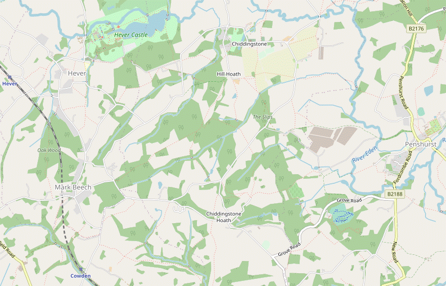
Cowden to Hever walk
A contrast between a remote part of the Weald and three attractive and popular Kent villages.

DSCF0986
Converted oast house, Salmans Manor
Jun-09 • Sean O'Neill
banner, swcwalk78, swcwalk92, swcwalks 5442689561645889746 P

DSCF1181
Hole Cottage near Markbeech
Jun-09 • Sean O'Neill
swcwalk78, swcwalks, walkicon 5442690706088797538 P

1005300146
Penshurst Place
May-10 • Sean O'Neill
swcwalk78, swcwalk92, swcwalks, walkicon 5483890487590077618 P

1005300146
Penshurst Place
May-10 • Sean O'Neill
swcwalk78, swcwalk92, swcwalks, walkicon 5483888194384376274 P

CIMG6337
The Chiding Stone
May-13 • Sean O'Neill
swcwalk235, swcwalk78, swcwalks, walkicon 6094509320592338034 P

CIMG8439
Harden Vineyard in August
Aug-13 • Sean O'Neill
swcwalk235, swcwalk78, swcwalk92, swcwalks, walkicon 5914268117646008306 P

CIMG8439
Harden Vineyard in August
Aug-13 • Sean O'Neill
swcwalk235, swcwalk78, swcwalk92, swcwalks, walkicon 5914275095818401698 P
| Length |
Main Walk: 16¼ km (10.1 miles). Three hours 55 minutes walking time. For the whole excursion including trains, sights and meals, allow at least 8 hours 30 minutes. Circular Walk: 19½ km (12.1 miles). Four hours 45 minutes walking time. |
|---|---|
| OS Map |
Explorer 147. Cowden station, map reference TQ476417, is in Kent, 6 km SE of Edenbridge. |
| Toughness |
4 out of 10 (5 for the Circular Walk). |
| Features |
This walk starts from a lonely station and wends its way through remote valleys, woods and tiny settlements in the undulating landscape of the High Weald. It descends into the Eden Valley for refreshment stops in the beautiful villages of Penshurst and Chiddingstone, before ending in Hever. Each of these three villages has an interesting church which is worth visiting, as well as a popular historic house open to the public. Penshurst Place is a well-preserved medieval manor house with an attractive formal garden, the home of the Sidney family since the 16thC. It is open weekends from mid-February to March, and daily from April to October; admission is £15, or £13 for the gardens only (2024). Chiddingstone Castle is a castellated manor house rebuilt in the 19thC, containing an unusual collection of art and curiosities left behind by its late owner, Denys Eyre Bower. It is currently open Sun–Wed from April to October; admission is £11 (2024). The grounds are normally open daily (free entry but donations welcome). Hever Castle, the childhood home of Anne Boleyn, was restored in the early 20thC by William Waldorf Astor and features some spectacular gardens. It is open daily from April to October and on some dates in November and December; full-price admission to the castle and gardens is £22 (2024). The second half of the Main Walk will be familiar to anyone who knows the Hever to Leigh walk (1–19), but the recommended lunch and tea stops are in different villages and the only significant overlap is the section from Chiddingstone to Hever (done here in the reverse direction). The Wealden soil does not drain well and parts of the walk can be muddy even after moderate amounts of rain. |
| Walk Options |
A longer variation lets you complete a Circular Walk back to Cowden station. This includes some nice views as you descend from Markbeech, but the narrow footpath leading to this village can be both muddy and overgrown. Two short cuts are described which bypass Penshurst and Chiddingstone, saving 3½ and 1½ km respectively. Missing out either of these attractive villages is not recommended but they have been included to allow more time to visit one of the historic houses. An earlier version of this walk included directions from Penshurst and Chiddingstone to their nearest stations (on the Redhill–Tonbridge line); these link sections can now be found in the Leigh and Penshurst walk (#92). |
| Transport |
Hever and Cowden are adjacent stations on the Oxted–Uckfield line, which has an off-peak hourly service from London Bridge, taking 45 minutes to Cowden. On Sundays you have to travel from Victoria and change at Oxted, with a longer journey time of around 65 minutes. For all the walk options, buy a return to Cowden. If you want to finish the walk in Penshurst village, Metrobus 231 & 233 combine to give a regular service to Chiddingstone Causeway (for Penshurst station) and Edenbridge in one direction, and Tunbridge Wells in the other (Mon–Sat). If driving, there is a small free car park at Cowden station “for Railway users only”. The one at Hever costs £3.50 at all times (2024). |
| Suggested Train |
Take the train nearest to 10:00 from London Bridge to Cowden. |
| Train Times |
|
| Timetables |
|
| River Levels |
|
| Lunch |
Unless you are bypassing Penshurst, the suggested lunch place in this village is the refurbished Leicester Arms Hotel (07845-623821), after 6¾ km. This up-market establishment has a large garden and serves good food until around 3pm (later on Sun & BH). As an alternative you could detour to the Porcupine Pantry (01892-871277), just outside the main entrance to Penshurst Place and open daily to non-visitors; it has indoor and outdoor seating and serves light lunches and afternoon teas, but might struggle to cope with a large group. There is also a tearoom in the village, but the Fir Tree House (01892-870382) does not open until 2.30pm. An early lunch option might be the Rock Inn (01892-870296) in Hoath Corner, which has some outside seating at the front and a small back garden. As with any small pub in a rural location, call beforehand to check that it will be open (and serving food). Later in the walk at Chiddingstone the Castle Inn (01892-870371; closed Mon) serves good food and has a particularly attractive back garden. |
| Tea |
The popularity of Hever, Chiddingstone and Penshurst ensures a good choice of tea places on this walk. If you want to break for refreshment in mid-afternoon the suggested tea place is the Tulip Tree (01892-870326) in Chiddingstone. Tucked away in a converted coach house behind the Chiddingstone Stores, this popular tearoom is open daily to 5pm. When Chiddingstone Castle is open its equally good Tea Room (01892-870347) is open to non-visitors. The final refreshment place on the Main Walk is in Hever village, where the King Henry Ⅷ inn (01732-862457) is open all day and has an attractive garden. Allow at least 20 minutes to reach Hever station, 1½ km away. After Hever the Circular Walk passes the Kentish Horse (01342-850493) in Markbeech, which is open all day. Allow at least 25 minutes to reach Cowden station, 1¾ km away. |
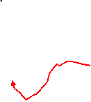
| Profile | |
|---|---|
| Help Us! |
After the walk, please leave a comment, it really helps. Thanks! You can also upload photos to the SWC Group on Flickr (upload your photos) and videos to Youtube. This walk's tags are: |
| By Train |
Out (not a train station) Back (not a train station) |
| By Car |
Start TN8 7DS Map Directions Return to the start: Finish TN8 7ER Map Directions Travel to the start: |
| Amazon | |
| Help |
National Rail: 03457 48 49 50 • Traveline (bus times): 0871 200 22 33 (12p/min) • TFL (London) : 0343 222 1234 |
| Version |
Jul-24 Sean |
| Copyright | © Saturday Walkers Club. All Rights Reserved. No commercial use. No copying. No derivatives. Free with attribution for one time non-commercial use only. www.walkingclub.org.uk/site/license.shtml |


Walk Directions
Click the heading below to show/hide the walk route for the selected option(s).


 Walk Map
©
Walk Options ( Main | Circ. || Full | ×Pen. | ×Chid. )
Click on any option to show only the sections making up that route, or the heading above to show all sections.
- Main Walk (16¼ km)
Walk Directions
Click on any section heading to switch between detailed directions and an outline, or the heading above to switch all sections.
- Cowden Station to Chiddingstone Hoath (3 km)
- From the station, take the minor road up Blowers Hill and turn right to go past Rickwoods Farm. Take a footpath on the left and then veer right at a path crossing to go through a long valley to Birchcope Shaw. Turn left and head north to reach a minor road just outside Chiddingstone Hoath.
- From the single platform? exit through (or around) the ticket hall, turn right and take the left-hand of two ways out to a minor road. Go uphill on this road for 100m, then turn right into Wickens Lane, signposted as a public footpath. Continue along this lane for 400m, passing the entrances to Rickwoods House and Rickwoods Farm.
- Shortly after the lane has gone downhill and curved to the left, turn left at a footpath signpost to go up a track leading to an isolated house. Just before reaching its front garden, go through a metal gate on the right to continue across a field. On the far side go through a gate in the hedge into a large field, where there are two footpaths ahead but no clear paths on the ground.
- Do not head for the pair of gates directly ahead but turn half-right, aiming for another pair further away. After going through these keep ahead past a footpath marker post at the top of a long curving valley. In the trees on the right-hand side go over a stile onto a woodland path running alongside it.
- At the end another stile takes you back out into the valley. Follow a grassy path along its centre for 500m, heading E. The next turning is easy to miss. About 125m before the valley narrows to a small gap, veer left on a faint path towards an isolated oak tree, near which there is an inconspicuous stile.
- Go over this stile and follow a woodland path down a slope. Cross a marshy area on a long wooden footbridge and turn left as indicated. In 40m fork right at a path junction to climb through the trees, heading N. Keep ahead where the path levels out and a wider path joins from the right.
- At the start of a large sloping field on your left, go through a small metal gate and continue on an enclosed path along its right-hand edge, climbing gently. As you approach the top corner there is a stile on the left, because the right of way currently goes across a muddy patch at the top of the field to a metal kissing gate in the tree boundary.
-
The suggested route, however, is to ignore the stile and take a new permissive path, waymarked with yellow arrows. Go through the tree boundary ahead and follow the path round to the left. At a T-junction turn left as indicated, briefly heading back towards the large field. In front of a fieldgate turn right onto a narrow woodland path, passing the kissing gate from the field and rejoining the right of way.
The right of way might be officially diverted onto this alternative route in future.
- At the end of the trees go through a gate into another field and keep ahead alongside a hedge for 200m. In the far corner go through another gate onto a minor road just outside Chiddingstone Hoath.
- Chiddingstone Hoath to Salmans Manor (2 km)
- Continue towards Hoath Corner, optionally detouring into the hamlet to visit the Rock Inn. Skirt round the edge of Puckden Wood to Oakenden Farm and continue past Harden Vineyard to reach Salmans Manor.
- Cross the road carefully and continue on the footpath opposite, with a wooden fence and an abandoned driveway on your right. After climbing gently for 100m, fork left to emerge onto a plateau. Head N on a grassy strip across the middle of a large field and turn right on the far side to reach a road.
-
Main route
- Turn right briefly onto the road. In 60m turn left through a side gate onto a broad track running along the top of a large sandstone outcrop, with a steep drop beyond the trees on your left. After slowly descending the track emerges from the trees and continues with a wire fence on the left. At the far end go over a stile to the right of a metal fieldgate.
-
Route via the Rock Inn (+350m)
- Turn left onto the road. Follow it downhill into a dark cutting between rocks and tree roots, taking care as there is no pavement. As you emerge into the hamlet of Hoath Corner there is an impressive sandstone outcrop in a depression on the left. Follow the road round to the right at a junction to find the Rock Inn on the right-hand side.
- From the pub, return to the road junction and keep left. Bear left at a public footpath sign onto the driveway in front of some houses and continue on a broad grassy path going downhill between fences, veering left at the bottom into Puckden Wood.
- Follow the path as it bends right and then left to climb gently through the trees. At the top leave the wood and continue along the left-hand side of a triangular strip of grassland. At the far end go through a small metal gate on the right, past a metal fieldgate and over a stile.
- Go along a fenced-in path on the edge of a field, heading SE. In the corner go over a stile, down a few steps and turn left onto a track. In 100m keep right at the entrance to “Skipreed”, soon emerging into the top of a large open area. Follow the enclosed tree-lined path down between two large fields.
- At the bottom go over a stile and continue through a wood. In 100m follow the path briefly round to the right, but almost immediately turn left by a low wooden marker post. Follow a narrow path through a belt of trees and along the edge of Harden Vineyard?.
-
After passing the vines go through a metal kissing gate into a small fenced-off field and leave it through another gate in the far corner. Bear left on the other side to go across a small enclosure and through a wooden kissing gate into a field. Turn right and go along its right-hand edge.
You might be able to glimpse Penshurst Place ahead, 2 km away.
- Near the bottom corner, go through a wooden gate and down a small flight of steps. Go through another gate and turn right onto a tree-lined track, which in 100m comes to a fieldgate. Go through a wooden side gate onto a tarmac lane at a bend by the buildings of Salmans Manor.
- Salmans Manor to Penshurst (1¾ km)
- Take the path heading east which goes across the River Eden to The Warren. Continue on a track towards Penshurst, then on the B2188 into the village.
- There is a fine view of a large mill pond opposite a particularly attractive oast-house conversion from the lane to the left, but the walk continues in the other direction. Almost immediately turn right in front of a “Private Road” sign onto a wide track with a bridleway marker, heading SE. In 100m this comes to a tall hedge, where you turn left through a metal kissing gate.
- Follow a fenced path around two edges of a large field, with more kissing gates along the way. From the opposite corner continue along a path to a footbridge, crossing over the River Eden?. Turn half-right to go across a patch of grass towards a small metal gate (not the fieldgate to its left).
- Go through the gate and up the left-hand edge of a large field, which leads into a concrete lane by some cottages. Go all the way along this lane, in 600m coming out onto the B2188 by a school on the outskirts of Penshurst.
- Turn left and follow the road into the village, passing some attractive old buildings (note the horseshoe-shaped doorway? in the garage). In 200m keep right at the junction with the B2176 to come to the Leicester Arms Hotel on the right.
- Penshurst to Wellers Town Road (3 km)
- Briefly head east along the B2176 and turn left through Leicester Square into the churchyard, joining the Eden Valley Walk (EVW). Go past the west front of Penshurst Place and diagonally across the grass to the B2176. Turn back towards the village for a short distance, then turn right and follow the old coach road to Wat Stock.
- For the suggested route out of Penshurst, turn right out of the pub onto the B2176. Unless you want to visit Penshurst Place or have lunch in its café, turn left after 75m into a small square of picturesque houses.
-
Detour to Penshurst Place (+1 km)
- Go past the square and keep ahead through a stone and brick archway onto the access road to Penshurst Place. At the end of the garden wall veer left across the large car park to find the Porcupine Pantry 200m away, next to the visitor entrance. Afterwards, return to the B2176 and turn right into the square.
- Go through the picturesque Leicester Square? and under an archway into the churchyard, joining the Eden Valley Walk? (EVW). Take the path round the left-hand side of St John the Baptist's church? (which is worth visiting).
- Leave the churchyard through a metal kissing gate and continue on a grassy path, soon with a fine view of Penshurst Place behind the hedge-topped stone wall on your right. Where the path splits fork left, heading NW across the grass towards a metal kissing gate 200m away.
- Go through the gate and turn sharp left onto the B2176, heading back towards Penshurst for 125m. Just after a 30mph road sign turn right down the lane to Salmans Farm, signposted as a public bridleway.
- In 500m this old coach road crosses the River Eden and you fork right up a track, with increasingly fine views over the Eden Valley on your right and later with a huge array of polytunnels in the fields on your left. Follow the main track for 1½ km to the derelict farm buildings at Wat Stock and keep ahead where a lane (the short cut from Salmans Manor) joins from the left.
- Follow the lane past a pond and round to the right. 150m after this bend bear right onto a track and go through a gate to the right of a metal fieldgate. Go diagonally across a field on a grassy path and leave it through another gate to emerge on a minor road.
- Wellers Town Road to Hill Hoath direct (1 km)
- Cross the minor road and take the footpath heading north through a wood. On the other side, keep left to reach the hamlet of Hill Hoath.
- Cross the road (slightly to the right) and go through a metal kissing gate onto a broad woodland path. In 400m leave the wood through a gate and continue on a grassy tree-lined path. In 50m the path forks by a footpath waymarker post.
- For the short cut omitting Chiddingstone keep ahead, staying on the EVW. In 200m veer left towards some new buildings and pass to the right of them. Bear right in front of some stables, going past a few cottages in the hamlet of Hill Hoath. At a three-way road junction (where the lane ahead is the main walk route from Chiddingstone), turn left.
- Salmans Manor to Wellers Town Road direct (1¼ km)
- Take the lane heading north to Wat Stock and turn left onto the Eden Valley Walk (EVW).
- For the short cut omitting Penshurst, turn left onto the lane to head N, soon passing a large mill pond opposite a particularly attractive oast-house conversion. At the top of a long slope keep left, avoiding the entrance to Abbotsmerry Barn.
- The lane (now unsurfaced) continues between hedges, then enters a wooded area. After passing a pond it swings right and left and goes past some cottages. Turn left at a T-junction in front of some derelict farm buildings at Wat Stock, joining the full walk route and also the Eden Valley Walk? (EVW).
- …
- Wellers Town Road to Chiddingstone (1¼ km)
- Cross the minor road and take the footpath heading north through a wood. On the other side, leave the EVW by forking right onto a footpath which leads over a small hill into Chiddingstone's main street. Turn left into the village.
- …
-
Leave the EVW by forking right onto a narrow path near the edge of the wood. In 200m go through a wooden kissing gate into a large farm field. Ignore the path ahead across the field and veer left onto a broad path going uphill, slightly away from the field edge.
You will now be following the Walk 1–19 route (in reverse) through Chiddingstone to Hever.
-
The path goes past an isolated tree and leads to a projecting corner of the field. Go through a gap and continue down a tree-lined path. At the bottom turn left onto the main street through Chiddingstone?.
- In 30m you could turn left onto a signposted path to see the Chiding Stone?, 200m away. If you take this detour, return the same way.
- There are a couple of refreshment places along the picturesque village street. Opposite St Mary's church? the Tulip Tree tearoom is up a passageway beside the Chiddingstone Stores. The Castle Inn is the last building on the left before the road turns sharply to the right.
- Chiddingstone to Hill Hoath (1¼ km)
- If they are open the suggested route is to cut through the grounds of Chiddingstone Castle, rather than skirting around them on the road. On the other side head south on the lane to rejoin the EVW at Hill Hoath.
- At the right-hand bend there is a pedestrian entrance into the grounds of Chiddingstone Castle, which include an attractive fishing lake and some pleasant woodland paths beyond the lawns around the house.
-
Road route
- Continue along the road for 500m, with views of the manor house beyond the lake. At a crossroads turn left onto a lane, soon passing the main entrance to the castle (the exit for the alternative route).
-
Castle Grounds route
- Go through the gate, passing a “Welcome to Chiddingstone Castle” information panel with a map of the grounds. Follow the path as it curves round, crosses an arm of the lake on a footbridge and goes up to the manor house.
- To go directly to the Tea Room without visiting the house and its collections, turn left and go round to the back of the house to find the gift shop and tearoom in the far corner.
- After exploring the grounds, return to the front of the house and turn left. Go past its entrance and follow the driveway as it curves gently round to the right past the car park. It leads out to a lane where you turn sharp left, almost doubling back.
- Stay on the lane as it heads S for 700m, passing some private exits from the castle grounds. As you enter the hamlet of Hill Hoath fork right at a junction onto a lane signposted as a public bridleway, rejoining the EVW.
- Hill Hoath to Hever (village) (2½ km)
- Head west on the EVW all the way to Hever.
- On the short lane you pass an attractive low-lying house Withers? on the right. At the end keep ahead on an earth track, crossing the first of several horse rides. At the top of a small rise the bridleway goes through a sandstone rock cutting, then descends. Shortly before the end of a field on your left, fork right onto a footpath which crosses more horse rides.
- The woodland path soon goes down a flight of steps and across a stream on a footbridge. Continue on a narrow (and potentially muddy) fenced path as it zig-zags right and left. At the end go straight across a lane onto the continuation of the footpath, usually with llamas or alpacas in a field on your right.
- The path eventually passes a cottage and comes out onto a private road. Bear right to cross over the road and follow a short path round to the left past some bushes, emerging onto a broad grassy verge alongside a driveway.
-
Shortly after a right-hand bend the right of way used to continue along a woodland path to the right of the driveway, but unless a collapsed footbridge up ahead has been replaced you have to stay on the drive. Just before reaching a gate across it bear left to rejoin the original right of way and follow the path round to the left in front of the grounds of Hever Castle.
Through the trees you can sometimes glimpse events taking place in the grounds, but there is no view of the castle or its ornamental gardens from the public footpath.
- On this enclosed path you will probably have to negotiate one or two awkward waterlogged stretches. The path eventually crosses a stream and goes up a slope to enter a churchyard. Go past St Peter's church? and out through its lychgate to Hever Road, with the King Henry Ⅷ inn opposite.
-
Detour to Hever Castle (+1 km)
- To visit the castle turn right onto the road and bear right to go through a gateway to the ticket kiosks. The moated castle and its formal gardens are some 400m further on. Afterwards, return to the road by the pub.
- Hever (village) to Hever Station (1½ km)
- Continue on the EVW, initially along a road and then south-west on a track. At a road junction keep ahead onto Hever Lane. After crossing the railway bridge, turn right into a driveway and continue on a path which drops down to Hever station.
- Stay on Hever Road as it turns sharply right by the pub. In 450m it comes to a T-junction where you turn right. In 50m turn left through a new wooden kissing gate onto a surfaced path.
- Follow this enclosed path for 500m, towards the end going between the attractive Chippens Bank House? and its ornamental lake. The path eventually comes out onto a minor road at a junction.
- You could turn right for Hever station (as indicated by the road sign) but the suggested route is to keep ahead on the road towards Cowden village. Go over the railway bridge (with the station visible on your right), then in 40m turn right into a driveway, still following the EVW.
- Go through a wooden fieldgate across the drive and keep right by the entrance to the last house. As you approach the station fork right onto a path down the slope. This leads directly onto Platform 1, for trains to London.
- Hever (village) to Markbeech (3 km)
- Take the footpath heading south from the pub, leaving the EVW. Go across a lane and continue on the footpath opposite, but before reaching Meechlands Farm turn right onto a footpath leading to Uckfield Lane. Head north along the road for a short distance, then turn sharp left onto a footpath which goes under the railway and heads south through Oak Wood to Bramsell's Farm. Turn left onto Cowden Pound Road to reach Markbeech.
- On the bend in Hever Road by the pub, leave the EVW by taking the driveway heading S, signposted as a footpath. After passing Hever Primary School continue on a path which leads to a minor road at a bend. Bear left onto the lane for 50m, then veer right up the continuation of the footpath and go through a kissing gate into a large field.
- Continue to head S, keeping fairly close to the left-hand field edge. The right of way is straight ahead near the corner of the field, but the path here crosses the outflow from a pond and you could veer a little way to the right where there is a wide gap in the trees. In the next field, aim for the left-hand end of the hedge opposite, where it meets some trees. Go over a stile here and turn right to head W on an enclosed path.
- The path later goes gently downhill and comes out onto a road (Uckfield Lane) by the Greyhound restaurant. Turn right and go along the road for 125m, then turn sharp left by a house “Wedgwood” onto a signposted footpath. In 350m the path goes through a high brick archway in the railway embankment and swings left up a slope.
- Follow the path through Oak Wood for 800m, climbing steadily and heading S. After going alongside a more open area on the left for about 125m, fork left at a path junction as indicated by a yellow waymarker. This narrow and potentially muddy enclosed path goes past paddocks and later alongside the grounds of a house before reaching a road.
- Turn left and go along the road into Markbeech (or Mark Beech, according to the road sign). As you approach the crossroads at its centre you pass Holy Trinity church on the right, with the Kentish Horse pub – the last refreshment place before Cowden station – just beyond it.
- Markbeech to Cowden Station (1¾ km)
- Take the footpath heading south-west from the churchyard, going downhill along field edges. Continue through a strip of woodland alongside the railway, eventually passing Cowden station. Go out onto a road and double back under the railway bridge for the station entrance.
- From the pub, make your way onto the driveway leading to its car park and go through a gate into the churchyard. Follow the tarmac path past the church door and keep ahead on a faint grassy path towards a metal gate in the hedge.
- Leave the churchyard via the gate and bear left across a field towards the left-hand side of a wide gap 125m away. Bear left there to go halfway down the side of a large field, with views of Ashdown Forest ahead and a wood on your left.
- At the end of the trees veer left through a kissing gate beside a metal fieldgate and continue in your previous direction, now with a hedge on your right. In a potentially muddy patch at the bottom of the field go over a stile onto a woodland path, curving round to the left and soon passing the picturesque Hole Cottage? in a clearing on the right.
- At a triangular path junction (with a large beech tree in the centre) keep left to continue through the strip of woodland, now with a stream down to the right. Ignore a path leading to a footbridge over this stream but fork right at the next path junction, with a post containing two footpath markers.
- The path goes gently downhill for a further 500m, with the railway (which has emerged from Markbeech Tunnel) in a cutting on the left. After passing Cowden station the path goes up to a stile which you go over onto a road.
-
Turn left to go under the railway bridge and turn left again into the station's access road. If the ticket hall is locked you can go past it to get onto the single platform?.
The platform is used by trains in both directions, so be careful not to take an Uckfield-bound train by mistake. These are scheduled to go through seven minutes before the London train, which is going from left to right.
- A wall plaque commemorates the victims of the Cowden rail crash, a fatal accident in October 1994. Five people died when a northbound train passed a red signal in thick fog and collided head-on with another train on the single-track section to the south-east of the station.
- Harden Vineyard grows Regent grapes which are used to make a rosé wine.
- The source of the River Eden is in the Titsey Estate, on the slopes of the North Downs near Oxted. It is one of the main tributaries of the River Medway and flows into it 1½ km downstream, just outside Penshurst.
- The large horseshoe-shaped doorway in the shop / garage is a relic of its days as the village smithy.
- Some of the half-timbered and tile-hung houses around Leicester Square (named after a favourite of Elizabeth Ⅰ) are Victorian imitations, like the post office house of 1850. “My Flesh also shall rest in Hope”, inscribed on the archway from the churchyard into the square, is from Psalm 16:9.
- The Eden Valley Walk runs for 24 km, linking the Vanguard Way to the west of Edenbridge with the Wealdway and the Medway Valley Walk in Tonbridge. There are few rights of way alongside the River Eden itself and from Penshurst much of the route actually follows the River Medway.
- The Sidney Chapel in St John the Baptist, Penshurst contains many memorials and a fine armorial ceiling, restored in 1966. By the side altar is the Luke Tapestry (in Greek), made by Penshurst's former village doctor: it honours the partnership between medical science and Christianity.
- Chiddingstone remains largely unspoilt because the Streatfeild family sold many of the buildings to the National Trust in 1939. It has been used as a location in period films such as A Room with a View.
- The Chiding Stone is a large sandstone boulder where wrongdoers were supposedly told off (chided) by the other villagers.
- St Mary, Chiddingstone contains many memorials to the Streatfeild family. On display is a Vinegar Bible of 1717, so called because in St Luke's Gospel, Chapter 20, “The parable of the vineyard” is written as “The parable of the vinegar”!
- Withers is a 15thC timber-framed hall house, with the bricks on the ground floor being added in the 19thC. The side facing the lane is actually the rear of the house.
- St Peter, Hever dates from the 13thC, but the church was completely refitted in 1894. Its north-eastern chapel contains the very worn Purbeck marble tomb-chest of Sir Thomas Bullen (Anne Boleyn's father), and there is a fine brass of Margaret Cheyne (d.1419) in the raised chancel.
- Chippens Bank House is a 16thC timber-framed house, much modernised and extended. From 1949-80 it was owned by the Everest Trust, a charity set up so that ‘worthy people could have a holiday somewhere’. More recent private owners have included a UK fly-fishing champion, who constructed the lake and stocked it with trout.
- Hole Cottage is the remnant of a much larger medieval hall-house, the rest of which was demolished in 1833. It is managed as a holiday cottage by the Landmark Trust.
If you want to detour to the Rock Inn in Hoath Corner, take the alternative route in [?].
If you are taking the short cut omitting Penshurst, go to §F.
If you are doing the full walk via Chiddingstone, go to §G.
Continue the directions at §I.
On a day when the grounds are open to the public you can take the more interesting route in [?].
This section continues to follow the Walk 1–19 route (in reverse).
If you are doing a Circular Walk back to Cowden station, go to §K.
Walk Notes
» Last updated: October 20, 2024
Return to Top | Walk Map | Walk Options | Walk Directions.