Dartford to Greenhithe walk
Riverside walk along the banks of the Darent and the Thames with stunning views of the Dartford river crossing
London Jan 14 2017
5dii swcwalk202 dartford canon london thames swcwalks 31934946280
London Jan 14 2017
5dii swcwalk202 dartford canon london thames swcwalks 31934947550
London Jan 14 2017
5dii swcwalk202 dartford canon london thames swcwalks 31934948930
London Jan 14 2017
5dii swcwalk202 dartford canon london thames swcwalks 31934950420
London Jan 14 2017
5dii swcwalk202 dartford canon london thames swcwalks 31934951780
London Jan 14 2017
5dii swcwalk202 dartford canon london thames swcwalks 31934953360

London Jan 14 2017
5dii swcwalk202 dartford canon london thames swcwalks 31934955030
| Length | 11.3 km (7.0 mi) |
|---|---|
| Toughness | 1 out of 10. Level, largely firm under foot. The eastern half of the walk should not be attempted if there are flood warnings for the Thames. |
| OS Maps | Explorer series number 162 Landranger series 177 |
| Walk Notes |
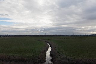
Wild riverside ramble by the banks of the Darent and the Thames, featuring stunning views of the Dartford river crossing. This is Kent, but not the garden of England. It is the Thames, but not the picturesque Thames of Oxford or the familiar London river. This is a walk through the edge lands, where everything is in a state of flux, where the normal rules do not apply and the land is constantly under threat of being overwhelmed by the river or the Thames Gateway project to warehouse the poor, or both; where human endeavours, great and marginal, crop up quickly, flourish and decay, leaving only remains; where the desolate heathland, which once covered much of England, still remains. This is the wild, wide, working Thames, frightening in its potential power. This is the first of a 5 walks along the Kentish Thames. You can find the complete set at http://kentishthames.wordpress.com Refreshments: Shops and Cafes in Dartford , Asda shop and cafe on route at Greenhithe , 2 pubs off route in Greenhithe . Public toilets: At stations Acknowledgements: Thanks to the writers Iain Sinclair and Nicola Barker, who inspired this series of walks. |
| Travel |
Train or bus to Dartford Station (buses arrive slightly to the south of the station) The route starts at Dartford Station.(Trains from Charing Cross and London Bridge) The exit is on the south side of the station. At the time the route was being researched the station was being rebuilt. The exit was at the south east side of the station. From this exit walkers should turn left on the road and then left again to cross the river Darent on a wooden footbridge. The completed terminal building may be the other side of the road but you should still exit the terminal going east (to the left as you face away from the tracks). The walk ends at Greenhithe Station |
| Thames Path |
This walk is part of the Thames Path [wikipedia] [National Trails] - a 184 mile national long distance path - that follows the Thames from its source in Kemble to the Thames Barrier at Charlton in SE London. There is an unofficial 10 mile south bank extension on to Crayford Ness. It follows the river's historic towpath where possible. In a few places, nearby paths are used instead as towpath sections do not match up where former "horse ferry" crossing have been lost. Through London, and on to the sea, there are north and south bank paths. |
|---|---|
| Author | © Copyright Chris Smith except where otherwise stated and licensed for reuse under this Creative Commons Licence
This is one of a number of walks created for the Ramblers by Chris Smith of Travellog Lewes (www.travelloglewes.co.uk). You can find more about the area around Lewes by visiting. To join the Ramblers, click here, or to become involved in helping them to protect rights of way follow, click here |
| Profile | |
| Help Us! |
After the walk, please leave a comment, it really helps. Thanks! You can also upload photos to the SWC Group on Flickr (upload your photos) and videos to Youtube. This walk's tags are: |
| By Train |
Out (not a train station) Back (not a train station) |
| By Car |
Start DA1 1BP Map Directions Return to the start: Finish DA9 9NQ Map Directions Travel to the start: |
| Amazon | |
| Help |
National Rail: 03457 48 49 50 • Traveline (bus times): 0871 200 22 33 (12p/min) • TFL (London) : 0343 222 1234 |
| Version |
Apr-24 Chris Smith |
| Copyright | © Saturday Walkers Club. All Rights Reserved. No commercial use. No copying. No derivatives. Free with attribution for one time non-commercial use only. www.walkingclub.org.uk/site/license.shtml |


Walk Directions
- [1] When this route was checked the exit was on the opposite side of the station. You should turn away from the centre of town, get down to the road and follow it to the left so that you reach the other side of the station and then you can find the river and the wooden footbridge.
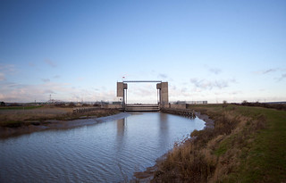
- On the bridge over the river you will find signs for the Darent Valley Walk which lead you straight ahead through a car park and then left on a road that passes under the railway. At the end of this road turn right across a busy road and then left almost immediately, down a road through an industrial estate.
- Take the first ungated turning on the left. This looks a bit like an entrance to an industrial unit, but if you continue you emerge again on the banks of the Darent. Turn right immediately before crossing the river. You have re-joined the Darent Valley Walk, which you will follow to the Thames. Up to the A206 your route is right beside the river.
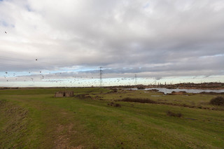
- [2] When you reach the A206 the legal right of way goes across the road, but unless the river is very high it is better to follow the river under the bridge. From now to the Thames the route runs on top of the flood defences, so twists and turns, but the way is clear and waymarked. This area is called Dartford Marshes.
- When this route was being checked there were cattle being grazed along the marshes and a bull in the field. There was also some shooting near the right of way.
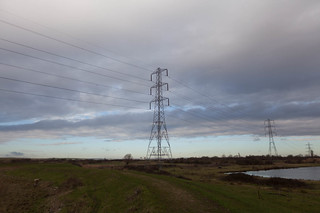
- [3] On reaching the Thames you are forced to turn right. A splendid vista opens up. On your left is the awesome Thames and ahead of you the Queen Elizabeth Bridge, a mighty piece of architecture. If you have had enough a track just after point 3 leads back to point 1 (Further up it can be heavily used by lorries) But if you want to continue, walk along the top of the flood defences. The right of way runs on the nearest one to the river, but you may get better views from the more southerly defence, which is a little higher.
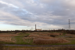
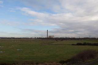
- A narrow path leads between the Thames and the semi derilect Littlebrook Power Station. Notice the injunctions to potential demonstrators on the wall. These are the result of protests at a nearby power station against continued use of coal for power. Littlebrook was never threatened. Across the river you may see ships manoeuvring at the container dock to the west of the bridge.
- Go under the bridge and continue along the river until your way is blocked by industry.
- [4] Follow the path to the right. This brings you out to the road. Turn left and walk for about 20 metres. Do not attempt to cross the forecourt of the Asda petrol station, but instead turn left, down a sunken path which runs alongside the petrol station and then behind Asda. Emerge into a new housing estate and keep straight ahead. You arrive at a square. Turn right here. You can see the pedestrian entrance to the Asda café and supermarket here.
- Leave the square by the exit road and turn right at the junction with the main road (The pubs of Greenhithe are off to the left). Walk ahead to the large roundabout and then left up a hill to Greenhithe station.