Dover to Deal walk
Easy cliff walk following the Saxon Shore Way along the 'White Cliffs of Dover' to historic Deal
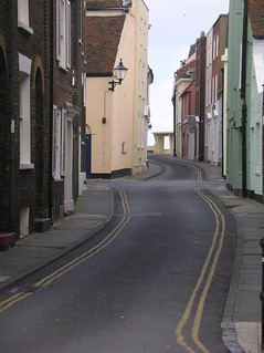
Book 2, Walk 30, Dover to Deal
Deal, Kent on a Saturday afternoon
book2 110306 walkicon swcwalks dovertodeal walk30 tocw230 279341411
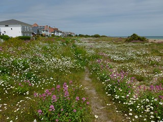
Walmer Beach
Jun-12 • Saturdaywalker on Flickr
book2 walkicon swcwalks walk30 dealtodover26612 7341926672

Looking back to St Margarets
Jun-12 • Saturdaywalker on Flickr
book2 walkicon swcwalks walk30 dealtodover26612 7156723895

Near Dover
Jun-12 • Saturdaywalker on Flickr
book2 walkicon swcwalks walk30 dealtodover26612 7341927452

Bench on clifftop
St Margaret's Bay, Dover to Deal walk
May-15 • Saturdaywalker on Flickr
book2 walkicon swcwalks walk30 17020359663

Port of Dover
Dover to Deal walk
May-15 • Saturdaywalker on Flickr
book2 walkicon swcwalks walk30 17640799621
Along the White Cliffs of Dover
| Length | Dover to Deal (or vice versa): 17.7km (11 miles). Taking a bus from St Margaret's Bay: 8.2km (5.1 miles) |
|---|---|
| Maps | OS Landranger Map 179 Explorer Map 138 (though the last mile or so is on 150) |
| Toughness | 3 out of 10 |
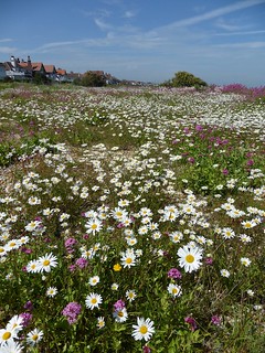
| Features | This simple walk (it should be impossible to get lost if you keep the sea on your right hand side) is nevertheless one of the finest coastal walks in England, taking you right along the top of the famous White Cliffs of Dover. On a clear day, you get stunning views of the English Channel, and the ferries buzzing in and out of Dover Harbour, and the French coast from Boulogne to Dunkerque. Surprisingly for a walk that seems to spend much of its time on the airy heights, not much exertion is involved. There are only two significant climbs, one out of Dover and the other out of St Margaret's Bay. Otherwise the terrain is level or gently undulating. The last quarter of the walk, indeed, is totally flat, along a tranquil coastpath behind the pebble beach of Deal. Though less dramatic than the White Cliffs, this section of the walk is full of historical and natural interest, passing Walmer and Deal castle, and – in late May and June – a stunning display of coastal flora on Deal’s shingle beach. Warning: From the outskirts of Dover to Kingsdown (the Zetland Arms) your mobile phone may switch to a French network. Depending on your contract, you may incur roaming charges, and your phone may also switch to French time (one hour ahead of the UK). |
| Walk Options | a) Taking a bus St Margaret’s Bay: You can cut the walk short by taking a bus back to Dover from St Margaret’s Bay, making a walk of 8.2km (5.1 miles). The bus passes right by Dover Castle, and buses from the same stop go to Deal, should you wish to have more time to explore that fascinating town. b) Deal to Dover: There is a lot to be said for doing this walk in the reverse direction, including getting the longest train journey over first, and the fact that scenery gets more and more dramatic as the day goes on, ending in the magnificent cliffs just before Dover. You then walk down into town of Dover which admittedly can seem a bit cheerless after such a lovely walk, but most of the walk through the town is on the seafront. In this direction you also have a choice of lunch pubs: you can have stop after just 4.6km/2.9 miles at the Zetland Arms, which has some outside tables right on the beach, or carry on for another 4.7km/2.9 miles to the Coastguards pub in St Margarets Bay, with its pleasant terrace overlooking the sea. Meanwhile there is a positive embarassment of tea options, starting with the Bluebirds tea room just before St Margaret's Bay (if it is still open: in 2022 it was operating Friday to Sunday 10-3pm only), the seasonal tea kiosk on St Margaret’s beach, tea and cakes served in the Coastguard pub which some report to be very good, the Pines Garden Tea Room, and Mrs Knotts’s Tea Room in the National Trust-owned South Foreland lighthouse. If none of those tempt you, the White Cliffs Visitor Centre on the cliffs overlooking the Port of Dover also serves tea, and in the town itself there is a Weatherspoons pub and a Costa Coffee open till 6pm Monday to Friday, 5.30pm Saturday and 4.30pm Sunday. |
| Transport | One train an hour runs from London St Pancras to Dover Priory (a high-speed supplement is payable, journey time 1hr 05 minutes), though you can also take a Canterbury-Margate train and change at Ashford for Dover (journey time 1hr 12 minutes). Alternatively, there is an hourly train from London Charing Cross (journey time 1hr 50 minutes) daily, and the same on Mondays to Fridays only from Victoria (journey time 1hr 58 minutes). Catch the first train after 9am from St Pancras to get to lunch in St Margaret’s in good time: ideally that would mean an 8am train from Charing Cross or Victoria, but a 9am one is OK if you do not dawdle too much. Buy a day return to Deal, valid on Southeastern high speed or not, as appropriate. If you purchase your ticket from a Southeastern ticket machine (eg the ones on the mezzanine where the high speed platforms are at St Pancras), you can often get a cheaper Super Off Peak ticket (not available before 9.30 Mondays to Fridays). Trains back from Deal go hourly. Usually these run straight through to St Pancras and take 1hr 26 minutes to St Pancras, but in peak hours Monday to Friday (and seemingly rather erratically at other times), they go to Charing Cross, taking 2hrs 13 minutes. At such times, changing at Ashford International gets you to St Pancras in 1hr 48 minutes, while if trains are running direct to St Pancras and you want to change at Ashford to avoid the high speed supplement, it can take anything from 2hrs 30 to 2hrs 45 to get back to Charing Cross.In such cases it might even be quicker to return to Victoria via Ramsgate and Margate. There are buses every hour till 7pm (Monday to Saturday) or every two hours till 6pm (Sundays) from St Margaret's Bay to both Dover and Deal. |
| Lunch and tea places | The White Cliffs Visitor Centre on the cliffs above Dover port has a coffee shop with a view of the sea and outside tables. It serves sandwiches and cakes from 10am-5pm daily March to October and 11am-4pm November to February Mrs Knott’s Tea Room, 6km (3.7 miles) into the walk is a period tea room in the National Trust-run South Foreland Lighthouse and is open at the same times as the lighthouse itself, 11am-5pm from late March to late October. The Pines Garden Tea Room and Museum in St Margaret's Bay, 7km (4.3 miles) into the walk, serves light lunches and cakes from 10am to 4pm Wednesday to Sunday year round. The Coastguard (01304 853 051) on the beach in in St Margaret's Bay, 7.7km (4.8 miles) into the walk, describes itself as Britain’s closes pub to France. It is open and serving food all afternoon (at least in the summer months) until 9pm Mondays to Saturdays and to 6pm on Sundays. It has a pleasant open-air terrace directly overlooking the beach. There is also a tea kiosk on the beach in St Margaret's Bay, open daily in the summer and at weekends in the winter, though possibly not if the weather is poor. As well as tea and cakes it offers sandwiches, pasties, chips and other delicacies until 5pm or 6pm in summer and presumably just before dusk in winter. The Bluebirds tea room in the former coastguard hut just beyond St Margaret's Bay had resumed opening on Fridays, Saturdays and Sundays from 10 to 3pm in May 2022, but I am not sure if it is still operating in 2023. If open, this is a charming place to have tea. Zetland Arms (01304 370114). Located at the start of Deal Beach, 12.4km (7.7 miles) into the walk, this pub has some outside tables right on the beach. It is open for drinks all afternoon daily and serves food from 12pm to 3pm Monday to Wednesday, to 8pm Thursday to Saturday and to 5.30pm on Sundays. Deal Pier Kitchen at the end of Deal Pier is recommended as a tea stop for its tremendous views of the town, but it currently closes at 4pm Monday to Thursday and 5pm Friday to Sunday. As well as hot food and cakes, it also has an external tea kiosk with outside tables overlooking the sea. Otherwise, the seafront opposite Deal Pier has various cafes, bars and pubs, too many to list here. The prominent Port Arms pub on the seafront has now been modernised but the adjacent Kings Arm still retains a traditional air. The optional detour through the old part of Deal at the end of the walk also takes you to a traditional back street pub, the Ship Inn. |
| Sea swimming | The best place to swim in the sea on this walk is at St Margaret's Bay, a pretty spot which has a good depth of water for swimming at all times, apart from very low tide when there is a shallow sea over rocks, and seems to be relatively sheltered from currents. Walmer and Deal beaches (especially the former) offer plenty of tranquility but you will find that the tidal currents are very strong here, running northwards parallel to the shore when the tide is coming in and southwards when it is going out. This means that you find yourself swimming in one direction only and making almost no headway relative to the beach (or even going backwards). This is definitely not a place to swim too far from the shore. A slightly more sheltered beach may be the one at Kingsdown just south of the Zetland Arms pub, but the tide goes out quite a way here at low tide. Dover harbour seems an unlikely place for a swim, but it does have beaches and a designated swimming area, and is used for training by cross-channel swimming clubs. As well as the main beach, there is a small one at the far northern end of the esplanade, just before the walk route turns off it, which actually makes a very tranquil swimming spot. The port and the castle make a scenic backdrop. |
| History | As a port, Dover is nothing like as busy as it was in pre-Brexit days, but it is still fascinating to pause on the cliffs for a while early in this walk and contemplate the complicated workings of its huge Eastern Docks, the main ferry terminal. The town's other star attraction is its large medieval castle, which is well worth a visit, but really needs a day out of its own: this is just one of several disused military forts which are dotted around the town. Just in front of the castle and to the left of the church, is the remains of a Roman Lighthouse, which is clearly visible from the sea front. The cliffs below the castle contain a World War II bunker, from where the evacuation of the British and French armies from Dunkerque in May 1940 was coordinated. It was later converted to a civilian command centre for us in the case of nuclear war, before prime minister Margaret Thatcher closed all such centres as a waste of money: it is now open to the public as part of Dover Castle. Dover was also the English town that suffered most during World War II, being under artillery bombardment from German forces in France for the whole war. The White Cliffs of Dover were formed 80 to 65 million years ago at the bottom of what was then a tropical ocean. The chalk is made up of the small shells of millions of sea creatures. It is estimated that it took 10,000 years to create 15 milimetres of chalk (that is a million years to make 15 metres). In places the chalk is 250 metres deep. The cliffs are the terminus of the North Downs, which run all the way from Farnham, just south west of London to this point. Originally the ridge stretched across to France, but was broken by the ice 26,000 years ago during one of the ice ages, separating the UK from Europe. Incidentally, there are no blue birds over the White Cliffs of Dover: the famous World War II song was written by Nat Burton, an American who had never been to England. South Foreland Lighthouse was built in 1843 to protect shipping from the Goodwin Sands, which at low tide can be seen just off shore in the later part of this walk. Guglielmo Marconi, the radio pioneer, made the first ship to shore transmissions to this point in 1898, and it was also home to the world's first international radio transmission, to Wimereux in France. Owned by the National Trust, the lighthouse is open to the public from 11.00am to 5.30pm, Friday to Monday, March to October. St Margarets had a population of 419 in 1801, when a wall was put up to prevent the bay being used by Napoleon's invasion forces. Its proximity to the Continent (it is the closest place in England to France, at 29km or 18 miles distance) and hidden cove made it a popular landing place for smugglers for much of its history. The St Margaret's Museum, passed on this walk, is open daily from late May to early October. Deal beach is popularly supposed to have been the landing site for the forces of Roman general Julius Caesar when he came to Britain in 55 BC to see if it was worth invading. He apparently decided that it wasn't, and it was not until 43 AD that the Romans returned, under the emperor Claudius to permanently occupy the island. The Romans later turned Richborough, just up the coast behind Sandwich (both of which places are now inland) into their main port of entry into Britain Walmer Castle and Deal Castle were built by Henry VIII in 1539-40 as artillery platforms to guard against a threatened French invasion. They were never permanently occupied and saw only minor military action. Walmer Castle later became the official residence of the Lord Warden of the Cinque Ports (the ancient association of port towns in the South East of England, which were given special privileges by the crown). The Duke of Wellington, victor of the Battle of Waterloo fame, died here in 1852, as much later did WH Smith, founder of the newsagents: both men were Lord Wardens. Both castles are owned by English Heritage http://www.english-heritage.org.uk/ and open daily April to October, but at weekends only in winter. Deal has a rather sleepy air these days, but was a major port in the days of sailing ships. Convoys of ships used to collect in the area just off its beach, which offered a protected anchorage due to the presence of the sand banks of the Goodwin Sands offshore, and cargo would be loaded or offloaded from them using rowing boats. Because of the sandbanks, the area was known among sailors as The Downs (Downs coming from the same Saxon word as the word dune). At times up to 1000 ships could apparently be seen in the bay. The centre of Deal still retains some fine buildings from this era, best seen by taking the short detour at the end of this walk, as well as many cosy nautical pubs. The town has many useful information boards explaining its history |
| Book |
This walk was originally published in Time Out Country Walks near London volume 2. We now recommend using this online version as the book is dated. |
|---|---|
| Profile | |
| Help Us! |
After the walk, please leave a comment, it really helps. Thanks! You can also upload photos to the SWC Group on Flickr (upload your photos) and videos to Youtube. This walk's tags are: |
| By Train |
Out (not a train station) Back (not a train station) |
| By Car |
Start CT17 9SB Map Directions Return to the start: Finish CT14 6HD Map Directions Travel to the start: |
| Amazon | |
| Help |
National Rail: 03457 48 49 50 • Traveline (bus times): 0871 200 22 33 (12p/min) • TFL (London) : 0343 222 1234 |
| Version |
Apr-24 Peter |
| Copyright | © Saturday Walkers Club. All Rights Reserved. No commercial use. No copying. No derivatives. Free with attribution for one time non-commercial use only. www.walkingclub.org.uk/site/license.shtml |


Walk Directions
Full directions for this walk are in a PDF file (link above) which you can print, or download on to a Kindle, tablet, or smartphone.
This is just the introduction. This walk's detailed directions are in a PDF available from wwww.walkingclub.org.uk