Lewes to Seaford via West Firle walk
Glorious ramble over the South Downs to the sea covering areas less frequently walked
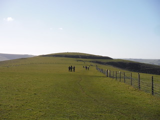
The Caburn (Iron Age Hill Fort) from route along Saxon Down
SWC Walk 181 - Lewes to Seaford via West Firle
Feb-18 • thomasgrabow on Flickr
swcwalks swcwalk181 banner 25486985877
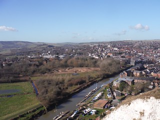
Lewes & River Ouse
SWC Walk 181 - Lewes to Seaford via West Firle
Feb-18 • thomasgrabow on Flickr
swcwalks swcwalk181 walkicon 40358732171
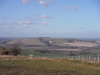
Mount Caburn from South Downs Ridge
SWC Walk 181 - Lewes to Seaford via West Firle
Feb-18 • thomasgrabow on Flickr
swcwalks swcwalk181 walkicon 38548787690

Easterly View along beach towards 7 Sisters
SWC Walk 181 - Lewes to Seaford via West Firle
Feb-18 • thomasgrabow on Flickr
swcwalks swcwalk181 walkicon 25486776217

Lewes, River Ouse and South Downs towards Ditchling Beacon
SWC Walk 181 - Lewes to Seaford via West Firle
Feb-18 • thomasgrabow on Flickr
swcwalks swcwalk181 39461736135
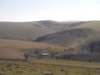
Oxteddle Bottom and Caburn Bottom towards Mount Caburn
SWC Walk 181 - Lewes to Seaford via West Firle
Feb-18 • thomasgrabow on Flickr
swcwalks swcwalk181 39461648475

Oxteddle Bottom
SWC Walk 181 - Lewes to Seaford via West Firle
Feb-18 • thomasgrabow on Flickr
swcwalks swcwalk181 25487091847
| Length | 22.3 km (13.9 miles); 544m of ascent and 545m of descent. You will need to allow at least 6 hours for the walk and for the full day out – trains and meals and drinks - 10 hours |
|---|---|
| Maps |
|
| Toughness | 7/10 - two major climbs; (but three if you opt for the valley route, rather than the circular ridge path in the Lewes to Glynde section). |
| Features |
This walk, along with the shorter options below, is mainly along ridges and offers superb downland views throughout with two excellent lunch-time pubs. The beauty of this walk is that you can see the way ahead so direction finding is fairly easy.
Author's Note: This is not the 15.4m Lewes to Seaford walk 24c in Time Book of Country Walks Volume 2 but a shorter, more direct variation which links sections of three different SWC walks to provide a glorious ramble over the South Downs covering areas less frequently walked. The shorter options from Glynde are suitable not just for summer but spring and autumn also and possibly in winter if done at a brisk pace and the weather is clear and fine. The main 13.9m walk is a companion walk to Book 1 Walk 31, Glynde to Seaford and Free Walk 47, Lewes circular via Glynde and Southease. |
| Walk options |
There are three options for shortening the walk
** There is no lunch-time pub on this short option. Unless you want to start with lunch in Glynde you need to take a picnic/snack lunch and have a meal in Seaford. You can also do a very short walk from Lewes to Glynde and from there catch a train back to Lewes or Brighton for connecting trains back to London. |
| Transport |
Trains These are from London Victoria and run direct to Lewes. You could also catch a train from London Victoria to Brighton and then take a connecting train to Lewes or Glynde. If you are starting the walk from Glynde then you can change at Lewes or catch a train to Brighton and take a connecting train. On a Sunday you have a better connection to Glynde via Brighton. Buy a day return to Seaford. This also covers you for journeys to and from Brighton If you end the walk in Glynde there are hourly trains from there to Brighton and Lewes. Bus You can take a leisurely bus-ride to the centre of Brighton from a bus-stop just 50m beyond Seaford Station. Car You can park in Lewes and catch a train from Seaford to Lewes or park in Brighton and again catch a train from Seaford to Brighton |
| Suggested train | If starting the walk at Lewes take the nearest train to 09.45. In British Summer Time for the shorter walks from Glynde you can take the nearest train to 10.45. |
| Lunch and Tea |
The Trevor Arms in Glynde has closed If you are following the route via West Firle your lunch-time pub is the Ram Inn at West Firle (01273 858222). This Pub and Bed and Breakfast is very popular in summer so you will need to ring ahead to book a table. There are no refreshment stops beyond West Firle until you have completed the 8.9m leg into Seaford so it is advisable to take some snacks and plenty of water with you on this long stretch. In Seaford the recommended tea stops are Papuchinos (at Seaford and Newhaven Sailing Club) and Salts Café in the recreation ground behind the sea-front road and about 400m from the station, which does soft drinks, tea and cakes and a range of excellent ice-creams. Open until about 6pm on weekends. If you did the short walk from Glynde to Seaford and want a meal there then Trawlers fish and chip shop is recommended. It is just a few yards from Seaford Station but is not open on a Sunday. There are other meal options in Seaford and it is worth googling “cafes in Seaford” to find some alternatives. Choice may be restricted on a Sunday when places tend to close early. |
| Profile | |
|---|---|
| Help Us! |
After the walk, please leave a comment, it really helps. Thanks! You can also upload photos to the SWC Group on Flickr (upload your photos) and videos to Youtube. This walk's tags are: |
| By Train |
Out (not a train station) Back (not a train station) |
| By Car |
Start BN7 2UP Map Directions Return to the start: Finish BN25 2AR Map Directions Travel to the start: |
| Amazon | |
| Help |
National Rail: 03457 48 49 50 • Traveline (bus times): 0871 200 22 33 (12p/min) • TFL (London) : 0343 222 1234 |
| Version | |
| Copyright | © Saturday Walkers Club. All Rights Reserved. No commercial use. No copying. No derivatives. Free with attribution for one time non-commercial use only. www.walkingclub.org.uk/site/license.shtml |


Walk Directions
It is best to use an OS map but as this is a “composite” walk using the instructions for three different SWC walks you can use these. You will need
- Time Out Country Walks Volume 2, preferably the latest 2011 edition, earlier editions will be fine but will mean you will have to follow alternative directions on the final leg of the walk ,
- paras 1 to 23 of the on-line download instructions for Book 1 Walk 31, Glynde to Seaford. The download instructions for Book, 1 can be found here.
Brief walk directions (use in conjunction with a map)
The main walk falls into 3 parts.
- Lewes Station to Glynde Station – Book 2 walk 25, pages 268-269 of the 2011 edition.
- Turn right out of Lewes station and head towards the centre of town
- Turn right on the main shopping street with its cafes and shops, and cross the bridge to continue straight on (on Cliffe High Street).
- Cross Malling Street and climb steeply up Chapel Hill to a golf club car park.
- At the end of the golf-club car park find a footpath sign and go through a wooden gate to follow the clear path away from the car-park .
- After 320m on this path the walk directions in the first para, column 2 on page 268 of the book suggest you veer slightly right to go downhill. However the suggested and much nicer route with superb views and which also saves you a stiff 700m climb is to continue ahead on the path at first walking below the golf course. After about a kilometre you go through a second gate and turn right to continue on a path making sure you stay on the top of the hill and not descending into the dips to your left and right. After about 400m the path goes down and up a small dip to cross a stile and you continue ahead for another 400m with a wire fence to your right after the first field, until you reach another stile just to your right. Here you pick up the directions in the penultimate paragraph, column 2 page 268 of the book, options (i) or (ii).
- Follow the path downhill all the way to Glynde. You go through a gate and turn left on a lane to pass the village shop.
- Turn right after the village shop and continue to Glynde Station.
- Glynde Station to the Ram Inn West Firle. Paras 1 to 23 of the download instructions for Book 1 Walk 31 Glynde to Seaford.
- Go past Glynde Station and the former Trevor Arms pub and continue along the road until you reach the busy A27. (It is not recommended you turn right just after the Trevor Arms to cross some fields as this adds nothing to the walk.)
- Cross the A27 and continue ahead along the lane until you reach a driveway to your left signposted to Preston Court. Here you can shorten the route – and not take lunch at the Ram Inn – by continuing ahead up the lane for almost 2km, climbing steadily until you reach the four-armed footpath sign, cattle grid and gate, marking the start of the Book 2 Walk 26 section of the walk.
- To continue to the Ram Inn at West Firle: turn left down the driveway , cross a stile just past a barn and continue ahead across a field
- Go through a swing gate and continue ahead, past a barn to then swing right on a lane past Preston House (on your left) to reach a cross-roads. Ignore all three roads here and go half-right through the entrance to Firle Park.
- Bear right across a grassy area to find a kissing gate 100m away and continue ahead across a field towards some tennis courts just visible ahead .
- Go through a gate with a cricket field ahead of you and bear right with a track to reach the Ram Inn in about 100m.
- Ram Inn, West Firle to Seaford
- Follow the download instructions from the Ram Inn (para 16) to near the top of the ridge (para 23) . Here do not turn left for the route to Alfriston – but climb a little further up the hill to find the clear ridge path and turn right to follow the path towards two tall radio masts in the distance ahead of you.
- Before the radio masts, you reach a small car park and a road descending to your right. Turn left here on the private road serving Blackcap Farm. After the farm the drive turns right towards the farm house, but you continue ahead through a wooden gate. Continue due South on a grassy path following the left edge of a field by a wire fence, soon passing a possibly dried up dew pond on your right. Go through another gate and continue more steeply downhill. You pass through a narrow belt of trees and after going through another gate the grassy path bottoms out. Go through a gate in to another field and continue through a lovely remote valley with no habitations in sight. The map names the hills on your right as Fore Hill and Snap Hill, on the left are Heighton Hill and Gardener's Hill and the valleys are Home Bottom and Snap Bottom. You reach a path junction where you follow the blue arrow to the right between hedgerows (not sharply right in to the next field).
- Shortly you reach the path junction at Point 5 of Book 2 Walk 26, Southease to Seaford (at the end of page 3 of the pdf on the SWC website). Turn left here (but note that a good alternative would be to continue ahead, following the directions for Walk 2/26).
- From the path junction descend to reach Poverty Bottom. This path becomes a car-wide track with a barbed-wire fence to your left and you soon pass buildings of the South East Water treatment works where the track becomes a tarmac lane. Continue along the lane to the hamlet of Norton.
- At Norton you come to a junction with a car-wide gravel track to the left and a house on the corner.
- Turn right through a gate at the junction and follow the car-wide cinder track for 700 metres. As you approach the top of the climb, the track turns to the right and you ignore a very faint path to the left. The map indicates several paths in this area, none of which are marked, but in practice you cannot go far wrong. In 70 metres, just before the top of the climb, you will see a concrete trough ahead, on the right of the path (this trough is also passed in 2/26). There are two grass paths to the left here; take the first path, just before an isolated bush (the second path, used by 2/26, is directly by the trough and they come together shortly). In 200 metres take a path to the left in to woods, rejoining Walk 2/26 on page 4 of the pdf at the kissing gate into the wood, marked 'In memory of Dick Dennis'.
- You pass Bishopstone station where you can pick up trains to Lewes or Brighton. Go under the railway bridge and past the entrance to Buckle Caravan Park, then follow the pavement round to the left. Go through the first gap in the barriers and turn left along the seafront, following signs for the Vanguard Way and the Sussex Ouse Valley Way, on a concrete path with the shingle beach on your right (or alternatively turn right instead for Seaford and Newhaven Sailing Club, which houses Papuchinos at the Galley, a convenient refreshment stop). Continue on concrete below the seawall, passing beach huts and a sign for Bönningstedt Promenade (in recognition of a twinning link with a German town). When the concrete comes to an end, leave the beach and cross the main road. After the houses on your left end, go through the first gap in the brick wall on your left and down a tarmac slope to enter The Salts (recreation ground). Cut diagonally across the grass, keeping to the left of a play area and cafe (another refreshment option), then cross the cricket field (unless play is in progress), towards a tarmac path (to the right of a cream coloured building and in the direction of the church). Once on the tarmac path, keep right of a car park in to Richmond Road, then turn left opposite Morrisons on Dane Road and left again for Seaford station.