Thames Path: Westminster to Greenwich via the south bank walk
The Thames path through central London, past Tower Bridge and the regenerating East End, to historic Greenwich.
| Length | 13 km (8.0 miles). If starting from London Bridge : 10 km (6.2 miles). No ascent |
|---|---|
| Toughness | 1/10, all on pavement, so wear trainers |
| Maps |
OS Explorers 161 (London South) and just a little bit of 173 (London North), a London A-Z, or TFL's Thames Path Leaflet (pdf) |
| Features |
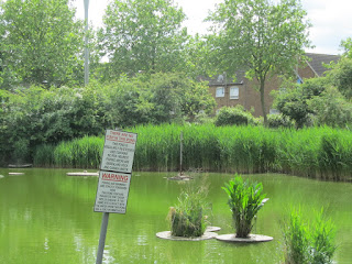
This walk along the Thames Path starts in central London and passes the London Eye, the Southbank Centre, Tate Modern, the Globe Theatre, London Bridge, Southwark Cathedral, HMS Belfast, Tower Bridge and riverside pubs and restaurants. It then changes, as you leave the touristy section, and becomes quieter in nature, passing through residential areas ('riverside living') with reminders of the areas industrial heritage, Dickensian in places. The contrast between the modern apartment blocks with riverside frontages, and the LCC 1920s blocks of flats on the other side of the road (away from the riverfront) is of interest to sociologists. 80% of the walk is along riverside path (with views back to the city), 20% is short detours around riverfront buildings. It ends in Royal Greenwich. Throughout there are views across the Thames. Take a camera! Navigation is easy - keep the river on your left-hand-side, and follow Thames Path finger post signs and Thames Path arrows in discs along the route. The directions which follow are not strictly necessary if you follow the waymarks; the directions are provided more for visitors to London wishing to go on a pleasant city walk, full of historic interest. The entire walk is on pavement or hard standings, so wear comfortable shoes, not walking boots. From the former County Hall the walk passes
|
| Walk Options |
|
| North Bank |
There is also a Thames Path on the north bank - you could add on SWC Walk 215 - Blackheath to Canary Wharf>, picking up the walk's directions from Greenwich, to walk through the Greenwich Foot Tunnel, then continue with the walk's directions to Canary Wharf or even back to Central London via the Thames Path, for a long circular walk (hard on the feet !). But note - on the north bank you have to detour frequently away from the river. |
| Mudlarking |
Mudlarking refers to the poor who used to scour the riverbed for things to sell. Nowadays, its undergoing a revival, and is quite popular, with its own reality TV series (Mud Men). There are steps down to the riverbed at many locations along the riverbank. So, at absolute low tide only, (and, as thay say, at your own risk only) you can go mudlarking yourself. You'll find clay pipes (smoking used to be done in displosable pipes), broken pottery, etc. Walking on the riverbed is allowed, as is searching by hand. But digging ('with any type of implement') requires a permit, and you have to report anything interesting. Don't do it alone. Wear mudproof shoes/boots. Be careful of Wells Desease (spread by rats urine through cuts in the skin), i.e. dont't touch your face and wash your hands afterwards. Links: Blog and About.com article |
| Swimming |
Swimming in the tidal Thames is not allowed. Prior permission (i.e. for organised events) is required. There are too many eddies and currents, not to mention a strong tide, and passenger boats. Matthew Paris' swim was the final straw! |
| Travel |
Westminster or Waterloo (for County Hall) and London Bridge are in Zone 1. Rotherhithe (London Overground), 2/3 of the way along, is in Zone 2 Cutty Sark (DLR) is Zone 2. Greenwich rail station is near by. If you have the time, the recommended means of returning from Greenwich to London Bridge or Westminster is on the Thames Clipper riverboat - for a comfortable, relaxing journey, with licensed bar on board. Travel cards are accepted to make the cost of the journey very reasonable. Journey time to Westminster 45 minutes. By Car: The whole area is residents parking. You might have a chance near Greenwich on a Sunday. Suggested Train: Start at 11am Suggested Meeting Place: Central London stations are very busy and have many exits. The meeting place for this walk is steps on the South Bank in front of the former County Hall building, opposite the Pret a Manger cafe, just before the London Aquarium. Its near both Westminster and Waterloo stations. |
| Links |
|
| Thames Path |
This walk is part of the Thames Path [wikipedia] [National Trails] - a 184 mile national long distance path - that follows the Thames from its source in Kemble to the Thames Barrier at Charlton in SE London. There is an unofficial 10 mile south bank extension on to Crayford Ness. It follows the river's historic towpath where possible. In a few places, nearby paths are used instead as towpath sections do not match up where former "horse ferry" crossing have been lost. Through London, and on to the sea, there are north and south bank paths. |
|---|---|
| Profile | |
| Help Us! |
After the walk, please leave a comment, it really helps. Thanks! You can also upload photos to the SWC Group on Flickr (upload your photos) and videos to Youtube. This walk's tags are: |
| By Car |
Start SW1A 2JR Map Directions Finish Greenwich Map Directions |
| Amazon | |
| Help |
National Rail: 03457 48 49 50 • Traveline (bus times): 0871 200 22 33 (12p/min) • TFL (London) : 0343 222 1234 |
| Version |
Apr-24 Andrew |
| Copyright | © Saturday Walkers Club. All Rights Reserved. No commercial use. No copying. No derivatives. Free with attribution for one time non-commercial use only. www.walkingclub.org.uk/site/license.shtml |


Walk Directions
Westminster (or Waterloo) to London Bridge via the southbank
- From Westminster tube station: Cross Westminster Bridge to the south bank, and turn left down some stairs (towards the London Eye/big wheel) onto the south bank riverside path.
- From London Waterloo station: Exit opposite the high number platforms, go through the glass doors, down the stairs, and turn left. Cross the road by the roundabout, and continue on in the same direction along pedestrianised street to the river. To reach the meeting point, turn left, towards the London Eye (big wheel). Just past it is the meeting point. Or, to start the walk, turn right
- Meeting Point: The suggested meeting place for groups is in front of the former County Hall, just below the steps down from Westminster Bridge on the south bank, opposite the Pret a Manger cafe, just before the London Aquarium.
- You now walk along the Embankment for 1.7 miles towards London Bridge, with the River Thames on your left-hand side.
- In more detail. You will pass the following landmarks and sites on your right [left (L) where noted]
- In 100 metres pass the London Eye (L).
- Keep ahead past Jubilee Gardens. Useful public WCs at far end of gardens (50 p)
- Pass the Southbank Centre
- Go under Waterloo Bridge. Waterloo railway station is over to your right
- Pass National Theatre complex
- Pass ITV studios
- Pass Oxo Tower, and Wharf (L)
- Pass Doggett's pub (popular with SWC walkers)
- Go under Blackfriars Bridges (road and railway). There is an entrance to the railway station just ahead of you
- Tate Modern (free entry) is soon on your right (recommended, walk through the large turbine hall)
- The Millenium Bridge is on your left
- Pass the Globe Theatre
- Pass Bankside Pier (L)
- Go under Southwark Bridge
- Pass the Anchor pub
- Go under Cannon Street Railway Bridge
- Head along the narrow Clink Street, passing the Prison Museum and Ruins of Winchester Palace
- You come to a replica of the Golden Hinde ahead of you. Turn right, then left past Southwark Cathedral
- Keep ahead to go under London Bridge, with London Bridge Hospital on your left
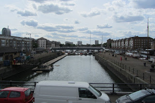
London Bridge to Rotherhithe via the southbank
- If starting from London Bridge station : Exit the station at the Tooley Street Exit. Cross the road, and walk through Hays Galleria to the Thames Paths. Turn right on Queen's Walk East (with the river on your left hand side), to join the main walk
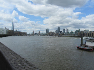
- Continue on Queen's Walk East - and walk past HMS Belfast, and City Hall to Tower Bridge (1 km)
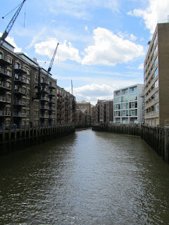
- Go under Tower Bridge and head along Shad Street, with its cobbles, and converted 19th century wharfs and warehouses to left and right, some connected at high level by enclosed footbridges. Continue to end of road to the Design Museum, where you turn left, then right to continue along the riverfront, to pass several riverside restaurants.
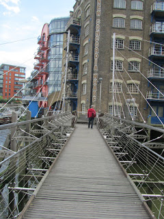
- At end of the riverfront, cross a pedestrian bridge with metal and wire sides, to access New Concordia Wharf. Head through a gate in the building (St Saviour Dock Bridge) and keep ahead on Bermondsey Wall West. Keep ahead again at the juncion (right) with George Row.
- At end of the road turn right into East Lane, then left into Chambers Street. You soon pass the Thames Tideway Tunnel (Super Sewer) site on your left. Follow waymarks into Fountain Green Square, to head along the riverfront. At its end, go down a ramp and turn left into Bermondsey Wall East.
- Turn right (inland) on Wilson Grove for Bermondsey tube station
- You pass, on your left, a memorial to and statue of Dr. Alfred Salter, and his wife and daughter.
- You now come to the riverside Angel Pub (recommended for those wanting an early lunch stop). Opposite the pub are the ruins of King Edward 111 Manor House in a green space. Now keep ahead for a short distance on the road, with Southwark Park to your right, and then follow waymarks back to the riverfront.
- At the end of this section of riverfront, return to the road (now Rotherhithe Street). You pass St Mary the Virgin Church on your right.
- You next come to the Mayflower Pub , another good lunch stop option. Just past the pub, on your right, is the Brunel Museum
- Turn right (inland) on Railway Avenue, for Rotherhithe tube station.
Rotherhithe to Greenwich via the southbank
- Turn left into Cumberland Wharf - the approximate site from where the Mayflower set sail for America - with a Pilgrims statue on the riverwalk. At end of walk, turn right down steps back to the road. You pass Rotherhithe Tunnel Shaft 2 on your left. Cross a swing bridge, and on your left is the Salt Quay Pub , a later lunch stop option - popular with families.
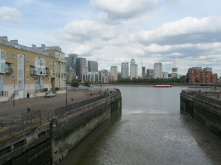
- Keep ahead on the road (Rotherhithe Street), passing a modern YHA hostel on your right, and Pacific Wharf on your left. On coming to King and Queen Wharf on your left, follow waymarks up steps for a riverwalk section. At its end, return to the road. You soon turn left for another riverwalk section, this time with heavily pollarded trees. Cross a metal bridge with metal railings and continue along another riverwalk. With the bend in the river, you now have Canary Wharf directly opposite you on the other side of the Thames.
- Your riverwalk is now called Pageant Crescent, and you pass a stone obelisk on your right (no indication to its purpose or what it is commemorating). At the end of the riverwalk go down two steps and return to Rotherhithe Street. You now pass the Blacksmiths pub on your left. Next turn left up steps into the Hilton Double Tree Hotel complex and follow Thames Path waymark signs to the right then left and back to the riverfront. On your next section of riverwalk, which passes through two locked-open metal gates, you have Durand's Wharf (pocket) park on your right.
- You go through another locked-open metal gate and then you pass through a set of tall, decorative metal gates into Surrey Docks Farm , with a tea room, and public WCs. Exit the farm through another set of tall, decorative metal gates and head along another section of riverwalk. At its end, turn right into Wyatt Close - a low rise residential development - and return to the main road. As this road swings to the right, turn left into Odessa Street and in 40 metres, turn right. Until the riverwalk ahead re-opens (when the New Pier Wharf flat development is completed) head along Odessa Street and at its end, turn left into Randall Rents, to rejoin the riverwalk.
- At Greenwich Dock, turn right, then left over a flat concrete road bridge (to the immediate right of a closed metal hump-back footbridge). Turn left to return to the riverfront.
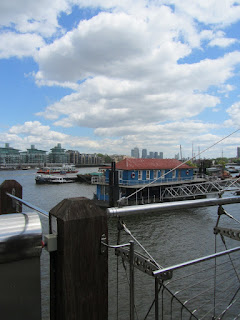
- Pass Greenland Pier (riverboat stop) on your left. Turn right, then left over Greenland Lock gates, then return to the riverfront, with a boatyard on your right. Keep ahead.
- You are now on the site of the former Royal Victoria Yard as you pass Deptford Wharf to enter the Pepys Estate. You pass the first of its three towerblocks (28 stories) on your right. There are a number of Napoleonic era cannons on the riverwalk. Pass the former Deptford munitions and provisions building (now residences) and at the end of the riverwalk, turn right, to head inland on what is the least interesting part of this walk - but it does not last too long.
- You are now on a gravel path as you head through Pepys (pocket) Park, passing a play and adventure area on your left. Go down steps and head through a grassy area in the estate, with another play area to your left. Exit onto Grove Street and turn left.
- In 200 metres, by a Thames Path sign, turn left into Sayes Court (another pocket park). In 40 metres by a waymark sign, turn right, to pass to the right of an ancient Mulberry Tree (believed to date from 1698 - planted to commemorate the visit of Czar Peter the Great - see later) - the tree is heavily propped up, in deference to its age. Pass to the left of a playground and exit the park through a decorative metal gate. In 70 metres, with a Coral bookmakers shop ahead of you, turn left into Prince Street.
- At a road junction with New King Street, keep ahead on Prince Street. You pass a closed pub on your right, and hoardings around a large vacant site on your right. At the end of the street, with the Dog and Bell pub on your right, turn left into Watergate Street. At the end of this street, turn right into Borthwick Street, to pass the quaintly named Twinkle Park on your right, and studios on your left. Folow the road around and where it turns sharply to the right, keep ahead, through barriers, and return to the riverwalk: on your left is the Ahoy Centre, a boatyard and training centre.
- In 200 metres you pass on your right the grand statue and memorial to Peter the Great . The Russian Czar visited England in 1698 for four months, to study shipbuilding.
- Cross a pedestrian swing pridge. Now continue on the riverwalk for 525 metres, passing new commercial and retail development on your right, until you come on your left to The Greenwich Foot Tunnel - and on your right-hand side the fully restored (post a fire) Cutty Sark tea clipper - worth a visit.
- Turn inland for 100m (signposted) to the Cutty Sark DLR (metro). There is a Wetherspoons pub (cheap) next to it. Its a further 300m for Greenwich station.
- Your other options at this point are as follows:
- A) for those who wish to continue their walk on the north side of the Thames (SWC Walk 215), take the foot tunnel (free) to Canary Wharf or beyond.
- B) continue along the riverside path to The Dome and North Greenwich tube (about 2 miles), or as far as the Thames Barrier (6 miles)
- C) explorer Greenwich (walk in to the Royal Park, and visit the Royal Observatory - about 1 mile return)
- D) catch the Thames Clipper river launch back to London Bridge or Westminster (recommended). The pier and booking office is some 65 metres beyond the Cutty Sark. £6.80 (in 2018) for Oyster/Contactless. Discounts from the ticket office for Travelcard (£6.40) and Freedom card (£3.40). Its the same price from The Dome (North Greenwich)
In Reverse: North Greenwich (the O2 Dome) to Central London via the southbank
- Leave North Greenwich tube station following signage to the O2, but keep straight and slightly to the right towards Wagamama.
- Turn right here and continue alongside some parkland on your right for about 160 metres until you reach Edmund Halley Way.
- Turn left here and pass the Emirates Airline (cable car) on the right until you reach Olympian Way.
- Turn left here keeping the river on your right.
- There are signs, and a few inland diversions along the way where there is no access to the riverfront, so the GPX would help