Macclesfield to Buxton walk
Tegg's Nose Country Park, Macclesfield Forest, lonely moorlands up to Shining Tor, and the wild Upper Goyt Valley to the historic Spa Town

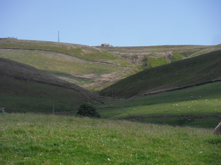
Emerging from Macclesfield Forest, The Cat & Fiddle on the distant ridge
SWC Walk 383 - Macclesfield to Buxton (via The Cat & Fiddle)
Jun-21 • thomasgrabow on Flickr
swcwalks swcwalk383 banner 51352173917
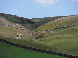
Approaching the Chest Hollow
SWC Walk 383 - Macclesfield to Buxton (via The Cat & Fiddle)
Jun-21 • thomasgrabow on Flickr
swcwalks swcwalk383 banner 51353651529
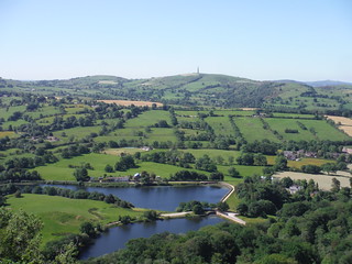
Croker Hill beyond Teggsnose and Bottoms Reservoirs, from Tegg's Nose
SWC Walk 383 - Macclesfield to Buxton (via The Cat & Fiddle)
Jun-21 • thomasgrabow on Flickr
swcwalks swcwalk383 walkicon 51353137503

Saddler's Way, Tegg's Nose Country Park
SWC Walk 383 - Macclesfield to Buxton (via The Cat & Fiddle)
Jun-21 • thomasgrabow on Flickr
swcwalks swcwalk383 walkicon 51352907681

Tegg's Nose, from near Lower Crooked Yard Farm
SWC Walk 383 - Macclesfield to Buxton (via The Cat & Fiddle)
Jun-21 • thomasgrabow on Flickr
swcwalks swcwalk383 walkicon 51353138798
In the Chest Hollow
SWC Walk 383 - Macclesfield to Buxton (via The Cat & Fiddle)
Jun-21 • thomasgrabow on Flickr
swcwalks swcwalk383 walkicon 51353140418
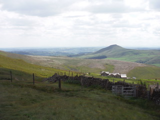
View from Stakeside, towards Shutlingsloe
SWC Walk 383 - Macclesfield to Buxton (via The Cat & Fiddle)
Jun-21 • thomasgrabow on Flickr
swcwalks swcwalk383 walkicon 51353652284
| Length |
25.0 km (15.5 mi), with 905/739m ascent/descent. For a shorter or longer walk see below Walk Options. |
|---|---|
| Toughness |
8 out of 10, with 7 hours walking time. |
| Walk Notes |
An exciting route from the fringes of the Dark Peak to the fringes of the White Peak, namely from the historic Silk Town of Macclesfield in Cheshire to the even more historic Spa Town of Buxton in Derbyshire. You climb steeply out of town along residential roads to quickly emerge amongst pastures and rolling hills and ascend further to Tegg’s Nose, a formerly quarried hill, with its handful of fine viewpoints, from where you descend through the Walker Barn Stream valley and rise again through Macclesfield Forest to the isolated Forest Chapel. Cross the Tor Brook valley and ascend along a road above the Clough Brook valley, lastly steeply up to the ridge separating Cheshire and Derbyshire.
Return by bus (faster) or train. The bus line also offers multiple ways of reducing the length of the walk. The latter parts of the walk are very lonely and exposed, in bad weather consider switching to the sister walk Macclesfield Circular via Tegg’s Nose and Kerridge Hill. |
| Walk Options |
Late Morning Shortcut from Forest Chapel, descend along Oven Lane to Bottom-of-the-Oven instead of routing down and up through the far north easterly corner of Macclesfield Forest (cut 1.5 km and 40m ascent).
Bus Line 58 (Macclesfield – Buxton via Cat & Fiddle), with an hourly service Monday-Saturday and five buses on Sundays and Bank Holidays, offers various stops on - or close to - the route toeither shorten the walk by cutting out a stretch at the start or by finishing the route early, and in any case of getting back faster from Buxton to Macclesfield (or London) than via the railway. Last return buses (as of 06/2021): Mon-Sat 18.06 Railway Station, 18.08 Market Place, Sun/Bank Holidays 17.10 Market Place. [See the route map for the location of the stops.]
|
| Maps |
OS Explorer: 268 (Wilmslow, Macclesfield & Congleton) – just for the urban start – andOL24 (The Peak District – White Peak Area)
|
| Travel |
Macclesfield Station, map reference SJ 919 736, is 237 km northwest of Charing Cross, 133m above sea level and in Cheshire East. Buxton Station, map reference SK 059 737, is 22km southeast of Manchester, 299m above sea level and in Derbyshire. It is on the Stafford to Manchester branch line off the West Coast Main Line from London Euston (hourly service). Travel time from London is from 101 minutes Mon-Sat (but 2 ¼ hours on Sun). Buxton Station is the terminus of the Buxton Line from Manchester, with two trains per hour Mon-Sat daytime and one per hour else. Journey time is an hour to Manchester, over three hours to London (chg. at Stockport). Saturday Walkers’ Club: The walk is doable as a daywalk from London with a train no later than 08.20 hours. |
| Elenvenses |
Tegg’s Nose Tea Room Tegg’s Nose Country Park, Buxton Old Road, Macclesfield, Cheshire, SK11 0AP (07955 532 703). The Tea Room is located 5.8 km (3.6 mi) into the walk. |
| Lunch |
The Forest Distillery Chambers Farm, Bottom-of-the-Oven, Macclesfield Forest, near Wildboarclough, Macclesfield, Cheshire SK1 0AR (01260 253 245). The distillery is located 11.3 km (7.0 mi) into the walk.
|
| Lunch or Tea |
Peak View Restaurant & Tea Room Buxton New Road, Macclesfield, Cheshire, SK11 0AR (01298 22103). The Peak View is located 13.8 km (8.6 mi) into the walk.
|
| Tea |
The Duke 123 St John's Road, Burbage,Buxton SK17 6UR (01298 78781). The Duke is located 2.2 km from the end of the walk.
|
| Profile | |
|---|---|
| Help Us! |
After the walk, please leave a comment, it really helps. Thanks! You can also upload photos to the SWC Group on Flickr (upload your photos) and videos to Youtube. This walk's tags are: |
| By Train |
Out (not a train station) Back (not a train station) |
| By Car |
Start SK11 6JP Map Directions Return to the start: Finish SK17 6AQ Map Directions Travel to the start: |
| Amazon | |
| Help |
National Rail: 03457 48 49 50 • Traveline (bus times): 0871 200 22 33 (12p/min) • TFL (London) : 0343 222 1234 |
| Version |
Apr-24 Thomas G |
| Copyright | © Saturday Walkers Club. All Rights Reserved. No commercial use. No copying. No derivatives. Free with attribution for one time non-commercial use only. www.walkingclub.org.uk/site/license.shtml |


Walk Directions
Full directions for this walk are in a PDF file (link above) which you can print, or download on to a Kindle, tablet, or smartphone.
This is just the introduction. This walk's detailed directions are in a PDF available from wwww.walkingclub.org.uk