Oxted Circular walk
The Greensand Hills on the Surrey/Kent border to Westerham, with an optional extension via Chartwell.

1007100005
Statue of Churchill, Westerham Green
Jul-10 • Sean O'Neill
banner, swcwalk63, swcwalks 5492593329237334930 P

CIMG2948
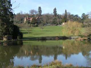
View from The Cearn
May-12 • Sean O'Neill
swcwalk63, swcwalks, walkicon 5744332270432753522 P

CIMG2883
Looking back down the Darent valley
Mar-16 • Sean O'Neill
swcwalk63, swcwalks, walkicon 6262278461609747378 P
CIMG4281
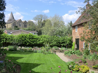
Quebec House garden and St Mary's Church
May-16 • Sean O'Neill
swcwalk63, swcwalks, walkicon 6387003613617427874 P

Beeches near Oxted
Oxted Circular walk
Nov-16 • Saturdaywalker on Flickr
swcwalks swcwalk63 walkicon 31107900386

| Length |
Main Walk: 19½ km (12.1 miles). Four hours 45 minutes walking time. For the whole excursion including trains, sights and meals, allow at least 9 hours. Long Circular Walk, via Chartwell: 22¾ km (14.1 miles). Five hours 40 minutes walking time. Short Circular Walk, omitting Westerham: 11½ km (7.2 miles). Two hours 50 minutes walking time. Alternative Walk, finishing at Westerham: 19 km (11.8 miles). Four hours 50 minutes walking time. Alternative Circular Walk, from Westerham: 10 km (6.2 miles). Two hours 35 minutes walking time. |
|---|---|
| OS Maps |
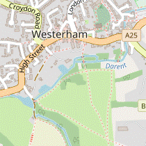
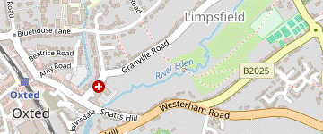
Explorer 147 & (for a small section at the start and finish) 146. Oxted, map reference TQ393529, is in Surrey, 15 km SE of Croydon. Westerham is in Kent. |
| Toughness |
5 out of 10 (7 for the Long Walk, 6 for the Alternative Walk, 3 for the shorter walks). |
| Features |
Much of this walk is on the wooded Greensand Ridge running parallel to and just south of the North Downs. At various points in the walk there are views across the valley to these downs, contrasting with far-reaching views out to the High Weald from the southern escarpment. The outward route is across the National Trust's Limpsfield Common, the High Chart (some of which is part of the Titsey Estate) and Squerryes Park. This brings you to Westerham, described by Daniel Defoe as a “neat, handsome, well-built market town”. Memorials in St Mary's Church and two statues on the Green honour two famous residents, General James Wolfe and Sir Winston Churchill. Wolfe was born in the town and his childhood home, named Quebec House after his famous victory in 1759, is owned by the National Trust. The house is open Wed–Sun afternoons from mid-March to October; admission is £7 (2024). The afternoon route starts with an attractive section up the open Darent valley and climbs onto the wooded Crockhamhill Common, from where an optional extension (see below) loops out to Churchill's family home Chartwell, also owned by the National Trust. The garden and restaurant are open throughout the year, but the house is only open from March to October; admission is £20 or £14 for the garden only (2024). The walk crosses over the outward route at Limpsfield Chart, continues through more parts of Limpsfield Common and returns to Oxted via the village of Limpsfield, which has retained many of its historic buildings. |
| Additional Notes |
This walk began as an attempt to extend the short Hurst Green to Oxted walk (2–16a) into Westerham but has evolved into a separate walk, almost as long as the main Walk 2–16. It was revised in 2018 to minimise overlaps with both its variations, in the process replacing a notoriously muddy stretch in the High Chart with a more appealing section via Ridlands Grove. The original start through Limpsfield has been transferred to the Oxted to Lingfield walk (#135). The sections of the walk around Chartwell had been revised earlier because the National Trust locked some back entrances into the estate in 2015. The revised version does a short loop from Crockhamhill Common to Chartwell via Mariners Hill, and drops the original Long Walk's different route back to Oxted (which still features in several other SWC walks). |
| Walk Options |
The revised walk's crossover design allows for several variations. Most simply, you can do a Short Circular Walk (similar in concept to Walk 2–16a) by only going out as far as Limpsfield Chart. A short extra loop via Moat Farm was added to this option in 2019, but you could simply turn back from the main route. The other variations all go via Chartwell. The Long Circular Walk loops out from Crockhamhill Common, taking in some fine views from Mariners Hill. It adds at least 3¼ km to the walk length; more if you also do the NT Estate Walk. This walk's original route to Chartwell is used here in the reverse direction to provide an Alternative Walk, looping back to Westerham. This would be useful if you spend time at Chartwell and want a shorter ending; Oxted is twice as far away. This design also means that you could do the second half as an Alternative Circular Walk from Westerham, although this is obviously easier for car drivers. Chartwell has a bus service on Sundays and Bank Holidays when the house is open, so you could finish the walk there on those days (details below). |
| Transport |
There is a half-hourly service from Victoria to Oxted, taking 40 minutes. There is also a faster hourly service (Mon–Sat) from London Bridge, taking 28 minutes. There is no station in Westerham but it is served by several bus routes for the walk options starting and/or finishing there. The most frequent service is London bus 246, which goes N to Hayes and Bromley (and starts from Chartwell on summer Sun & BH). There are three Metrobus services going W to Oxted (but none on Sun & BH), the 236 (Mon–Fri) and 594 / 595 (Mon–Sat). Go-Coach 1 (Mon–Sat) & 401 (Sun & BH) goes E to Sevenoaks. Although much of its route is outside the London boundary, Travelcards and Oyster PAYG can be used on the 246, even from Chartwell. If driving, Oxted station car park is free after 10am, but might be full on weekdays. Westerham has a large car park on the eastern edge of the town, free for the first three hours; street parking is possible away from the town centre. |
| Suggested Train |
Take the train nearest to 10:00 from London Bridge (or Victoria) to Oxted. A later train would be preferable for the Short Circular Walk. |
| Train Times |
|
| Timetables |
|
| Lunch |
There are three coaching inns in Westerham, about 9 km into the main walk variations: the Grasshopper on the Green (01959-562926), the Kings Arms Hotel (01959-562990), and the George & Dragon (01959-928414), now a Bel & The Dragon inn. There are also several cafés and tearooms in the town (see below). On the Short Circular Walk the suggested place is the Carpenters Arms (01883-722209) in Limpsfield Chart, after 6¾ km (or 5¼ km with the short cut). The only alternative pub is the Bull Inn (01883-713469) in Limpsfield, just 1½ km from the end of the walk. |
| Tea |
On the way into Oxted you could stop at Coffee at Kiwi House (01883-722785; open to 3pm Tue, 4pm Wed–Sat, closed Sun & Mon) on Limpsfield High Street. The route through Oxted on Station Road East passes many possible tea places, including a Costa at #62 (01883-712866; open to 5.30pm Mon–Sat, 4.30pm Sun) and an independent coffee shop at #85, Bru & Bear (01883-818390; open to 4pm Mon–Sat, 2pm Sun). There is also a Caffè Nero just past the station at #139 (01883-730220; open to 6pm Mon–Sat, 5pm Sun). Two places nearby on the other side of the station are Café Papillon at 54 Station Road West (01883-717031; nominally open to 5pm Mon–Sat but may stop serving earlier; closed Sun) and a JD Wetherspoon's pub, the Oxted Inn (01883-723440). In addition to its pubs there are many tea places in Westerham for the walk options ending there, including the Tudor Rose Tearooms (01959-562391; open to 3.45pm Mon–Fri, 4.30pm Sat–Sun) on the Green. There is a Costa (01959-565577) and Deli di Luca (01959-569726) up the A25 towards Market Square, and more places further along the main road. There are several places which function as mid-morning and/or mid-afternoon refreshment places. The Carpenters Arms (see Lunch above) is passed in both directions between Oxted and Westerham, and on the walk options via Chartwell you could visit its popular (and usually busy) Landemare café (01732-866368). |
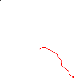
| Profile | |
|---|---|
| Help Us! |
After the walk, please leave a comment, it really helps. Thanks! You can also upload photos to the SWC Group on Flickr (upload your photos) and videos to Youtube. This walk's tags are: |
| By Train |
Out (not a train station) Back (not a train station) |
| By Car |
Start RH8 9EU Map Directions |
| Amazon | |
| Help |
National Rail: 03457 48 49 50 • Traveline (bus times): 0871 200 22 33 (12p/min) • TFL (London) : 0343 222 1234 |
| Version |
Jun-24 Sean |
| Copyright | © Saturday Walkers Club. All Rights Reserved. No commercial use. No copying. No derivatives. Free with attribution for one time non-commercial use only. www.walkingclub.org.uk/site/license.shtml |

Walk Directions
Click the heading below to show/hide the walk route for the selected option(s).


 Walk Map
©
Walk Options ( Short )
Click on any option to show only the sections making up that route, or the heading above to show all sections.
- Main Walk (19½ km)
Walk Directions
Click on any section heading to switch between detailed directions and an outline, or the heading above to switch all sections.
If you are doing the Alternative Circular Walk (from Westerham), start at §F.
- Oxted Station to Wolf's Road (2¼ km)
- Go down Station Road East, turn right into Johnsdale and keep left past a green to come to the A22. Cross over and go up a bridleway (Old Lane) parallel to the railway. Continue in the same direction on Rockfield Road and turn left onto the Greensand Way (GW). Head east across West Heath on a permissive path parallel to the GW, rejoining it by the former St Michael's school.
- Arriving from London, go down steps and turn right to go through a small parking area. Turn right again and go down Station Road East for 275m. At the end of the shops turn right into Johnsdale. Where this splits in front of a small green, fork left. At the end of the road keep left and go down an alleyway to the A25.
- Cross this busy main road with great care and take the bridleway opposite, to the left of a driveway. This old sunken lane climbs steadily and when you get to see the railway line on your right entering a tunnel, you are some way above it. 200m after crossing over a drive the track comes out onto Rockfield Road. Continue along it in the same direction.
-
In 100m turn left opposite a minor road (Icehouse Wood) into the left-hand of two driveways, signposted as a bridleway and briefly joining the Greensand Way? (GW). After passing a house this comes out onto West Heath (part of Limpsfield Common), with the GW continuing along the leftmost of several paths ahead.
The remainder of this section differs slightly from the Walk 2–16a route, taking a permissive path close to the GW until the two routes rejoin. If you prefer you could simply follow the GW all the way to Wolf's Road.
- Leave the GW by bearing right onto the sandy path curving gently away from it, with trees on the left and open heathland on the right. In about 150m fork left through the wooded common. Keep left through a small clearing and take a path into the trees parallel to the nearby lane on the left (the GW), avoiding paths into a depression on the right used by mountain bikers.
-
The woodland path gradually drifts away from the lane and gets closer to a road on the right, but eventually swings left and meets it in front of a large redbrick building, the former St Michael's school?. Turn right onto the lane to rejoin the GW and go past the building to come to Wolf's Road.
- If the woodland path is too muddy there are one or two places where you can veer left and join the lane before it reaches St Michael's.
- Wolf's Road to Tenchleys Wood (1¾ km)
- Follow the GW across Limpsfield Common to Brick Kiln Lane, then across Chapel Road. Turn left onto Pastens Road and go up to a path junction with Tenchley's Lane. Go via Headland's driveway onto a footpath going downhill alongside Tenchleys Wood.
- Cross the road carefully and continue on the bridleway opposite, heading E. In 200m this bends right towards another road (New Road). Cross over and go gently downhill on the continuation of the bridleway, now heading SE.
- Follow this bridleway through the wooded common for 500m, ignoring several permissive paths off to both sides. After going through a dip it climbs gently and eventually comes out onto a private road (Stoneswood Road) at its junction with Brick Kiln Lane.
- Cross Stoneswood Road and bear right to head S on Brick Kiln Lane. In 100m, just after a driveway on the left, bear left at a GW marker onto a path which leads to a golf tee. Cut across it onto a short path through the trees and turn left briefly onto a lane (Chapel Road). Immediately after passing Pains Hill Chapel? turn right onto a signposted footpath, which goes between fences for 200m.
- At the end turn left onto Pastens Road, joining the Walk 2–16 route from Hurst Green (1¾ km away). After the road bends right to head SE there are fine views over the Low Weald. The lane ends at a T-junction with a private road (Tenchley's Lane) in front of some houses, with a four-way footpath signpost.
- Leave the GW by taking the private driveway to “Headland” ahead on the left, which despite appearances is also a public footpath. In 40m, shortly before reaching a gate across the drive, go through a wooden gate on the left. Turn right and go all the way down a potentially muddy sunken path alongside Tenchleys Wood. At the end go through a new metal gate into the top corner of a large field.
- Tenchleys Wood to Limpsfield Chart direct (1¼ km)
- Turn left onto a new right of way below Tenchleys Wood. Join a bridleway coming up from Tenchleys Manor and turn sharp left onto a footpath going up a lane. Veer right onto a footpath heading north-east through a small wood and cross the B269 onto a small common at Limpsfield Chart.
- Do not take the obvious fenced path down the hillside, but instead turn left through another metal gate. This new right of way goes along the top of the field for 400m, although halfway along you will probably want to skirt around an overgrown stretch through a boggy area (as most walkers do).
- In the field corner go through two more gates, merging with a bridleway coming up the hill from Tenchleys Manor. Follow this round to the right, passing Tenchleys Cottage. Shortly afterwards there is a three-way signpost indicating a bridleway going steeply uphill to the left.
- You could take this rather gloomy path and turn half-right at the top onto the driveway to Quince House, but the suggested route is to carry on along the main drive and turn sharp left at the end onto a tarmac lane. In 100m bear right at a footpath signpost onto a narrow path along the grassy bank. At the end go up a few steps and past the entrance to Quince House.
- Follow the waymarked footpath uphill from the driveway, past a couple of houses. The right of way curves round to the right alongside a garden fence into a wood, then continues through a parking area and along a driveway to the B269.
- Cross this main road carefully and keep ahead on a short grassy path through some trees. Ahead on your right is the Carpenters Arms on Tally Road, the suggested lunch place on the Short Circular Walk.
- Limpsfield Chart to Goodley Stock Road (2 km)
- Head east alongside Tally Road and cross Moorhouse Road. Fork left off the GW and take a footpath heading north-east to Yalden Spring. Go past this onto a permissive ride heading north-east through the Titsey Estate. At a corner of the wood, continue eastwards on a path on the edge of the wood to Goodley Stock Road.
- Turn right in front of the pub to head E across the grassy area, staying close to Tally Road on your left. At the end go straight across a lane (Moorhouse Road) onto the signposted footpath opposite, with a GW waymarker. In 40m you pass a short wooden fence where another grassy path from Moorhouse Road merges from the right. In a further 30m fork left off the GW, also leaving the Walk 2–16 route.
- In 200m the path curves right and merges with one coming from High Chart car park on Moorhouse Road. In a further 100m, shortly after another path merges from the left and the main path bears right, go straight ahead on a narrow path. Keep ahead at path crossings? and follow the path into a hollow containing a large pond and some other pools of water, fed by Yalden Spring? under a sloping beech tree.
-
Go across the edge of the pond on a wooden footbridge and bear left onto a permissive ride into the Titsey Estate's High Chart (not the public footpath to its left), initially heading N.
If access through the High Chart is not possible (eg. because of forestry operations), use the Walk Map to devise an alternative route. One possibility would be to return to the Greensand Way, which includes a waymarked Link Route from Goodley Stock into Westerham. If you have to do this, continue the directions at [?] in §E.
- The broad track curves round to the right and later there is a large area of young trees on your right. Stay on the main track as it continues to bend right. It eventually comes to a T-junction where you turn left, briefly heading N. Almost immediately there are two paths off to the right, the first leading into a wood and the second into the corner of a large farm field.
- The simpler option is to turn right onto the first path, but the second would let you walk along the top edge of the field (parallel to the woodland path) with a fine view across the valley to the North Downs. Either way, keep ahead at a path crossing after 300m and continue to Goodley Stock Road at the far end of the wood / field.
- Goodley Stock Road to Westerham (1¾ km)
-
 Cross the road and keep left to come to a junction with a branch of the GW. Turn left and follow this towards Westerham. On the outskirts of the town, leave the GW and take a footpath which goes past the Kings Arms Hotel into Market Square. The George & Dragon is opposite and there are other places around the Green on the right.
- Cross the road carefully (the traffic can be quite fast) and take the left-hand path into the Squerryes Estate, heading NE. In 150m keep left where the path splits, staying near the edge of the wood. The path ends at a T-junction where you turn left, joining a Link Route for the GW.
-
On leaving the wood go across a track and through a metal kissing gate into Squerryes Park. Continue along a clear path in much the same direction, negotiating a few more gates and eventually going down a long slope between fences towards Westerham.
Squerryes Court? is in the valley down to the left, not visible from the public footpath.
-
At the bottom bear left onto a track which crosses the infant River Darent, just 2 km from its source. Opposite a large pond ignore a footpath on the right (the continuation of the GW and the return route after lunch), but immediately after the entrance to “Redwoods” fork right at another footpath signpost to go gently uphill on a track.
-
At the far end go across a lane (slightly to the right) onto an enclosed path, which leads into the car park for the Kings Arms Hotel. Turn left and go through it into Market Square on the A25, with the George & Dragon opposite. For other places turn right to find the Grasshopper on the Green and several cafés and tearooms.
- Westerham to Squerryes Park (1 km)
-
- If starting from Westerham, make your way to the Green.
- For a short cut take the GW Link Route from the Green, along Water Lane.
-
From any of the lunch places? (or if starting the walk here) make your way to the Green, with its statues of General James Wolfe and Sir Winston Churchill.
- The main route goes past the parish church and Quebec House on the way out of the town, but involves a slightly awkward crossing of the A25. For an easier route you can cross the main road below the centre of the Green and go along an alleyway (Water Lane), turning right at the far end onto a path running along the bottom of a field. If you take this short cut, skip to [?].
- For the suggested route leave the green in its top corner to go past St Mary's church?, which is worth visiting. Pass to the right of the war memorial and leave the churchyard by a kissing gate near Church Cottage. Go down a short alleyway to the A25 and turn left.
- Quebec House is on the left-hand side of this main road by its junction with the B2026 (Hosey Hill), but the walk route turns off the other side of the A25 opposite its entrance. If you are not visiting the house it is safer to cross the busy main road with great care well before the junction and then turn right into Mill Street, a private road which is also a public footpath.
- At a parking area at the end of this short lane, bear right up a path and go through a metal kissing gate into a meadow. Follow the path to the right, crossing a footbridge over the River Darent. Go through a gap in the hedge ahead and keep right to walk along the bottom of the meadow. In 150m you pass a wooden kissing gate on the right, the route of the short cut.
- Go all the way along the bottom of the meadow, with the river flowing through some large gardens behind the trees on your right. At the end cross the river on a footbridge and turn left onto a track. This leads into an open valley where you fork left through a gap beside a metal fieldgate onto a permissive path through Squerryes Park (the right-hand path up the slope is the outward route from Oxted).
- Squerryes Park to Crockhamhill Common (2¼ km)
- Follow the permissive path along the left-hand side of the Darent valley for 1 km, then veer right to join a public footpath on the other side. At the end of the valley head for Crockham House and go onto Crockhamhill Common. Take the footpath heading south across it for 500m, then turn right briefly onto a bridleway at a T-junction.
- Follow a clear path heading SE and later S along the valley floor for 1 km, going through a kissing gate along the way; on your left there is a steeply-wooded hillside behind the River Darent, interspersed with a number of old fish ponds. Eventually the path goes through a metal fieldgate and continues along a track between hedges (if the gate is locked there is a gap in the fence with the remains of an old stile 20m to its left).
- In 125m you come to a gate on the left leading to a broad grassy path into a valley, immediately followed by a crossing with a public footpath. In theory you should turn left at the path crossing and then go over a stile at the entrance to a wood? into the valley, but unless access is blocked it is simpler to turn left onto the broad grassy path.
- At the far end of the wood the valley path curves slightly left towards Crockham House, passing an isolated house tucked away in the trees away to the right. On the far side go through a metal kissing gate and continue in the same direction on the narrow footpath just off to the right, climbing quite steeply into the heart of the wooded Crockhamhill Common.
- Ignore temporary forest tracks or side paths and follow this woodland path for 500m, heading roughly S. The footpath eventually comes to a T-junction with a bridleway where you turn right. In 40m you come to another three-way path junction, with a footpath branching off to the left.
- Crockhamhill Common to Chartwell (1¾ km)
- At the next junction fork left onto the continuation of the footpath. Veer left past The Warren and leave the common in its south-east corner. Go across the B2026 onto Mariners Hill and take a permissive path looping round to the right (past a memorial) for the best views. Go back into the woodland and turn right down a bridleway. Before this comes out onto Mapleton Road turn left onto a permissive path parallel to the road, then veer right down the bank to come out opposite the visitor entrance to Chartwell.
- At this second path junction fork left to head S again on the footpath. In 150m you go past a clump of bamboo into a small open space in front of an isolated house, “The Warren”. Veer left across its parking area and take a path back into the wood, then in 20m turn right at a footpath marker post.
- Follow this narrow path gently downhill for 200m, heading SE, to come to a path junction at the edge of the wood. Immediately after merging with a bridleway from the left, turn left at a T-junction (essentially you are staying on the footpath as it crosses over the bridleway). After curving right the path straightens out to head E, with a large garden behind a hedge on your left.
- The path comes out onto a road (the B2026) on the inside of a sharp bend, with a private road (Froghole Lane) off to the right. Cross the main road with great care and climb a flight of stone steps near the start of the side road onto a wooded part of Mariners Hill.
- At the top of the steps turn right onto a woodland path, which soon comes to a bench at a viewpoint. Go through a new wooden gate, across a meadow and through another gate onto a path through a belt of trees, passing a memorial? stone.
- At the end of the trees go down a short flight of steps just off to the left and turn left onto a fenced path. Follow this path around the edge of another meadow, with more fine views off to the right. On the far side go back into the trees and turn right at a path crossing onto a bridleway going downhill, heading E.
- In 200m turn left at a path crossing (away from a new permissive path down to your right). After a short climb the path levels out, going along the top of a steep wooded bank; along the way there is a bench by a gap in the trees with a fine view of Chartwell and its grounds on the other side of Mapleton Road.
- The National Trust entrance to the property is 400m ahead. The path eventually meets the Greensand Way? (GW) and you turn right to go down a steep little bank onto Mapleton Road. The visitor entrance is opposite, while the GW continues on a footpath to its left.
- Chartwell to Hosey Common Lane (up to 2½ km)
-
Go through the car park for the NT Café. For the full walk, follow the signposted NT Estate Walk on a circuit around the woodland at the back of the grounds. Leave through a pedestrian exit onto Hosey Common Lane and turn left onto the lane.
- If Chartwell is closed, take the GW directly to Hosey Common Lane.
-
Unless Chartwell is closed to visitors, cross the road carefully into the grounds and immediately turn right onto a path down a grassy bank into the main visitor car park.
- If the grounds are closed you will have to take the Greensand Way uphill alongside them, starting from the left of the visitor entrance. At the top turn left onto Hosey Common Lane and continue the directions at §J.
-
If you are stopping here for refreshments, go through the car park to find the large NT Café on the right, opposite the NT ticket booth for the house and garden.
If you are not visiting the property, retrace your steps through the main car park.
- Visitors to Chartwell could join the Estate Walk en route by going through one of the gates at the back of the grounds and turning left onto it. If you do this, skip to [?].
- Make your way into the overflow car park. You can get onto the start of the Estate Walk directly from its top left-hand corner, or by going diagonally across the picnic area on the slope above it and leaving via a side gate beside a double wooden fieldgate.
-
Turn right onto the Estate Walk, uphill. About 40m beyond the picnic area it forks into two broad paths, both climbing steeply up the wooded hillside.
- If you want to cut out most of the Estate Walk (saving 1½ km), fork left. This leads directly to the exit onto Hosey Common Lane, where you can skip to [?].
-
Fork right and follow the path uphill and round to the right, then on an undulating stretch for about 500m to a signposted path crossing.
- If you want to cut out a loop of the Estate Walk (saving 1 km), turn left at this crossing and skip to [?].
- Keep ahead at the crossing. You will be looping back to this point on a parallel path down to the right and there are one or two short link paths, but for the full walk go all the way to the far side of the Chartwell Estate. Turn sharp right there to double back on this lower path running alongside a fence at the back of the grounds, with fine views across the lake to the house.
- Follow the path as it slopes up the hillside. Shortly after zig-zagging right and left it turns right again and climbs more steeply to return to the signposted path crossing on your outward route.
-
Take the path (signposted “Bomb Crater” and “Tree House”) up steps and round to the left. After briefly going alongside a field bear left onto a newly-laid path through the trees, leaving the main estate path.
- If this path is closed for repairs simply follow the main estate path to the exit onto Hosey Common Lane and skip to [?].
- On this path you pass the crater (with a distant view of the house) and then the recently-built tree house. The path swings right and goes through a coppiced area of woodland to a T-junction with the main estate path. Turn left to come to the exit in 60m.
- Leave the estate over a stile beside a wooden fieldgate and turn left onto Hosey Common Lane. In 200m you cross over the GW (the fall-back route from Mapleton Road when Chartwell is closed).
- Hosey Common Lane to Westerham (2½ km)
-
Head north-west along Hosey Common Lane. 100m before reaching the B2026, turn left onto a footpath to reach this road in front of Tower Wood. Follow a permissive track through the wood, which curves round to the right and goes past its folly.
- If Tower Wood is closed, take the public footpath running along its boundary.
-
Go along this quiet lane through the wooded Hosey Common for 500m. At the end of a fenced-off area on the left, turn left onto a signposted footpath. This brings you to the B2026 (Hosey Common Road) in 125m, with a fieldgate opposite guarding the entrance to Tower Wood?.
- If access through Tower Wood is no longer permitted, turn right and take the signposted public footpath running along its boundary, gently descending for 750m before curving left and coming out into the bottom corner of a field. If you have to take this route, skip to [?].
- For the main route, squeeze through a gap beside the fieldgate and take the left-hand of two tracks into Tower Wood, initially heading W. The track curves gradually round to the right and comes to a meeting of tracks around the ruins of a large brick watchtower, smothered in ivy.
- Go past this folly to continue in the same direction, gently descending on a long straight track heading N. In 600m it swings right and drops down more steeply. At the bottom of the wood turn sharp left onto the public footpath from Hosey Common Road, coming out into the corner of a large field.
-
Veer right to climb steeply uphill on a grassy path a little way out from the field edge. Go along the plateau for 200m, then take the left-hand of two grassy paths ahead (immediately after an oblique path crossing). In a further 150m go through a metal kissing gate and down a slope to the trees at the bottom.
-
Keep ahead through a wooden kissing gate onto a fenced path between gardens. After crossing the River Darent the alleyway (Water Lane) leads out onto the A25 opposite Westerham Green.
There are several tearooms and other refreshment places around the green. London bus 246 to Bromley leaves from the stop by Water Lane, and buses to Sevenoaks from the stop opposite. Buses to Oxted leave from the stop outside the Kings Arms Hotel (along the main road to the left, where there are more refreshment places).
- Chartwell to Crockhamhill Common (1½ • 3 km)
-
Retrace your steps through the car park.
- If you wish you can follow the signposted NT Estate Walk on a circuit around the woodland at the back of the grounds before leaving via the main visitor entrance.
-
…
…
Afterwards, retrace your steps through the main car park.
- If the grounds are closed or you do not want to do a circuit through the woodland outside the ticketed area, go back out through the main visitor entrance.
-
Optional Estate Walk (+1½ km)
- …
- …
- …
- Turn left at the crossing, going up steps and round to the left. Follow the main path around the back of the estate, ignoring an exit onto Hosey Common Lane.
- The path eventually veers left and drops steeply downhill. Go all the way down to the bottom and leave the grounds through the main visitor entrance.
- Go back across Mapleton Road and up the steps in the steep bank opposite the visitor entrance, briefly retracing your outward route on the GW. At the top of the bank ignore several paths off to the left, including the permissive path from Mariners Hill. Stay on the GW for 500m as it heads SW through the woodland, ignoring signposted footpaths off to both sides along the way.
- Towards the end of the wood go straight across a driveway and follow the path up to and then briefly alongside a high wooden fence. At the end of the fence bear right to go downhill on a sunken path which comes out onto the B2026 beside the drive you crossed earlier.
- Cross the road carefully and continue on the driveway opposite, still on the GW. After passing the entrance to April Cottage fork left to go gently uphill on a rutted track, heading W. In 100m (at a bridleway marker post) fork right off the GW onto another bridleway, a narrow path climbing through the trees.
- The path comes out into a more open area and curves slightly to the right. In 200m bear left at a path junction where the footpath from Westerham joins from the right. Retrace your earlier route for 40m to another three-way path junction.
- Crockhamhill Common to Limpsfield Chart (2½ km)
- At the next junction fork right, staying on the bridleway. In 250m keep ahead at a major path crossing, then fork left. After briefly merging with the GW veer left onto a narrow footpath which comes out onto the B269 near its junction with Goodley Stock Road. Head west along the B269 for a short distance and turn left up the driveway to Greystones. Bear right past the house onto a footpath which leads down to a lane. Turn right onto this, then fork left onto a footpath which goes along the side of Scearn Bank. At the end turn right onto Trevereux Hill and follow this lane up to the B269 at Limpsfield Chart. Go diagonally across a small common to the Carpenters Arms.
- At this second path junction fork right, staying on the bridleway and heading W. In 250m you come to a five-way path junction (with an oak tree at one corner) where you take the second path on the right, almost straight on. In 30m fork left at an unsignposted path junction.
- In 250m the path merges with the GW from the left. In a further 100m bear left onto a footpath just before a waymarker post showing that the GW veers right. Go straight across a signposted bridleway and follow the footpath as it makes its way through the trees towards the B269 (Kent Hatch Road); take care when you reach it as the traffic is quite fast and there is no pavement.
- Cross this busy road with great care, trying not to be distracted by the fine views ahead across the Weald. Turn right to walk alongside the main road; although the traffic is coming from behind there is slightly more room on this side. 100m past the junction with Goodley Stock Road, and just before the road sign welcoming you to Surrey, turn left into the driveway to Greystones, signposted as a public footpath.
- At the end of the driveway bear right onto a narrow path through the trees, heading SW. In 100m turn left at a T-junction onto an awkward little path which drops steeply downhill. At the bottom turn right onto another driveway.
-
Where the driveway starts to climb after 150m, bear left onto a signposted footpath. In 100m keep right and follow this broad woodland path for a further 500m as it climbs gently along the hillside (Scearn Bank).
- At the end of a semi-open area halfway along, a short out-and-back detour up a path on the right would take you to a bench with a view over the trees to the High Weald.
- The footpath eventually comes out onto a lane (Trevereux Hill) opposite “The Old School”. Turn right and follow it back to the B269. Cross the main road carefully (to the left of Moorhouse Road opposite), with St Andrew's church off to the right. Head NW across the common on a broad grassy ride to reach the Carpenters Arms on Tally Road, a possible mid-afternoon refreshment stop.
- Tenchleys Wood to Limpsfield Chart via Moat Farm (2¾ km)
- Go downhill on the footpath, past Tenchleys Manor to Itchingwood Common Road. Turn left and go along the lane to Moat Farm. Turn left onto a footpath heading north, then fork right onto one heading north-east. Turn left …
- Follow the fenced path down the right-hand side of the field. At the bottom go through another gate and continue on an enclosed path. On reaching a property turn right as indicated, crossing a ditch and going around two sides of its garden on a fenced path. At the end turn right onto a driveway, with a fine view of the picturesque Tenchleys Manor? behind a pond on your left.
-
After passing a few houses veer left at a footpath signpost, cutting across a patch of grass to the tree boundary. Cross a ditch on a wooden footbridge into a field and turn right to go along its edge. At the end go over a stile and turn left onto a lane (Itchingwood Common Road).
- If you miss the footpath from the driveway you could simply go all the way along it and turn left onto the lane at the end.
- The lane bends right at Moat Farm Cottages and then passes a cluster of buildings at Moat Farm, opposite a pond. Where it bends right again at the end of the buildings, turn left onto the grass verge and go through a small gap in the hedge (with an easily-missed footpath signpost leaning against the stone wall). Go up the left-hand side of a field and out through a metal kissing gate in the top corner.
- Ignore a footpath off to the right and keep ahead along the left-hand edge of a large field, heading back towards the Greensand Hills. Near the top of the field veer left to go through a kissing gate in the hedge and turn right along the top edge of the next field, climbing gently and ignoring another footpath sloping downhill.
- In the top right-hand corner go over a stile to continue in much the same direction on a woodland path, then out again into another field. Carry on along its right-hand edge, on a clear grassy path. Near the top of the field the path veers left up to a wooden fieldgate in the top corner. Go out along a short track and turn left onto a lane (Trevereux Hill).
- After climbing steadily for 300m the lane levels out, passes “The Old School” (where the Main Walk joins from the right) and comes to the B269. … …
- Limpsfield Chart to Ridlands Grove (1 km)
- Go past the pub into Post Office Row, round to the left. Go across Ridlands Rise onto a tarmac path through woodland to the B269. Turn right onto a bridleway going past Lombarden Farm and across a field. Turn left and go along Ridlands Lane for 100m, then turn right into Ridlands Grove.
- Go past the left-hand side of the pub into Post Office Row. Follow this lane round to the left, parallel to Tally Road. At the end cross over Ridlands Rise and continue on the tarmac path opposite, slightly to the left. This eventually reaches and runs alongside the B269, passing a side road (Caxton Lane) on the other side.
- Just past this junction turn right into a driveway, signposted as a public bridleway. This merges with another drive from the left and goes past the buildings of Lombarden Farm. At the far end go through a narrow gap in a hedge and turn left as indicated, along the edge of a field.
- Follow the field edge round to the right and keep ahead where the hedge ends, downhill on a grassy strip to a narrow road (Ridlands Lane). Ignore the signposted footpath opposite and turn left onto this quiet lane, taking care as there is no pavement. In 100m, where it bends right, turn right onto a bridleway into Ridlands Grove.
- Ridlands Grove to Limpsfield (2¼ km)
- Take any route to the opposite corner of the wood. Continue alongside a golf fairway and turn right onto a long straight bridleway leading to the club house. Go across the A25 and continue along the edge of the golf course, parallel to Grub Street. Cut across two golf fairways onto a footpath sloping down the hillside to Limpsfield's High Street. Turn right and go down this narrow street.
-
For the suggested route head N on the bridleway, turning right at a path junction after 100m to stay near the edge of the wood. The broad grassy path curves round to the left and goes gently downhill. At the bottom corner of the wood follow the path round to the left.
Shortly before reaching this corner you might see the remains of Hedgehog Hall, one of several whimsical creations? scattered around the wood. Peter Rabbit's Post Office is on the inside of the corner; on other routes you might come across Badger Barracks and Fox Villa.
- Continue on the path along the bottom of the wood, then in the same direction alongside a golf fairway. At the far end turn right at a major path junction onto a long straight tree-lined bridleway heading NW, with a string of properties behind a high wooden fence on your right.
- In 500m go past vehicle barriers and through Limpsfield Chart Golf Club's car park to the A25, with a lane (Grub Street) opposite. Cross the busy main road with great care to continue in much the same direction on a grassy path to the left of Grub Street, along the edge of the golf course.
- In 100m you cross a driveway, then in a similar distance come to a wooden seat carved out of a tree trunk, next to a Limpsfield Community Orchard Walk waymarker. When safe to do so (with golfers playing in both directions) veer left across two fairways, passing a clump of three trees in the middle.
- Go through a gap in the trees into a small clearing and turn left in front of a bench with a view of the North Downs (ignoring a footpath going down to the right in front of it). Follow a clear woodland path sloping gently downhill, heading WSW. In 100m keep right at a path junction to descend more steeply down the wooded hillside.
- The path eventually merges with a bridleway coming in from the right. Follow this out past a few houses and turn right to go down Limpsfield's traffic-choked High Street. Near the bottom you pass Coffee at Kiwi House and the Bull Inn on the right, two possible refreshment places.
- Limpsfield to Oxted Station (1½ km)
-
 Take the B2025 (Detillens Lane) from the mini-roundabout at the bottom of the High Street. In 300m turn right onto a footpath which goes across a meadow to Granville Road. Turn left and go along this road, Gresham Road and Station Road East to Oxted station.
-
At the mini-roundabout at the bottom of the High Street turn left onto the B2025 (Detillens Lane), passing a row of attractive half-timbered cottages on the left. In 300m (and 60m after passing a cul-de-sac, Padbrook, on the left) turn right onto a signposted footpath, a short path between garden fences. Go through a metal kissing gate and keep ahead on a grassy path across a meadow, heading W.
- This right of way across the meadow used to be clearly marked out, but if this is no longer the case you could take a grassy path on the left going around two sides of the meadow.
- If you have gone straight across the meadow follow the path round to the right in the corner. Cross a footbridge over the infant River Eden? and continue past some scrubland. Go through another metal kissing gate and along a narrow fenced path between houses to a residential street (Granville Road). Ignore the continuation of the footpath opposite and turn left onto the street.
- At the end of Granville Road keep left to go past Oxted Library on Gresham Road. At the T-junction by Tandridge Council offices turn right onto Station Road East. The station is on the left in 200m; you pass a Costa and several other refreshment places before reaching it, with Caffè Nero a little further along the road.
-
For trains to London from Platform 1 (and other refreshment places) go through the subway and up steps on the right to the station entrance. Café Papillon is the first place on Station Road West; the Oxted Inn is off to the left.
- The Greensand Way runs for 175 km from Haslemere in Surrey to Hamstreet in Kent, following the course of a sandstone ridge just to the south of the North Downs.
- St Michael's school closed in 2002 and is now a block of luxury apartments.
- Pains Hill Chapel is a small Independent Evangelical Church dating from the early 19thC.
- At about this point you cross over the course of the Roman Road from London to Lewes. Just to the north, the road ran through what is now Clacket Lane Services on today's equivalent form of highway, the M25. Some Roman artefacts from the area are rather appropriately displayed there.
- The small pool of water is Yalden Spring, said to be the uppermost source of the River Darent. This flows through Otford and Dartford into the River Thames.
- Squerryes Court is an attractive 17thC manor house, owned by the Warde family since 1731. It was used as Hartfield in a BBC production of Emma. Since 2012 it has no longer been open to the public.
- All three of Westerham's pubs were coaching inns. The George & Dragon took the private carriages and the Grasshopper Inn the public coaches.
- St Mary, Westerham dates from the 14thC, but was extensively restored in the mid 19thC. Its bell tower contains a medieval spiral staircase, highly unusual in that it turns to the left.
- This is the site of an Iron Age hill fort, although there is little to see as it is now completely overgrown.
- The Memorial on Mariners Hill commemorates the gift of this land to the National Trust in 1904.
- Tower Wood is part of the Squerryes estate and according to a Sevenoaks Council document “…has long been used by the public with the consent of the owner”.
- Tenchleys Manor is a 16thC house with 19thC extensions and alterations.
- The whimsical creations in Ridlands Grove were built by one of the National Trust volunteers with left-over timber after a woodland management day, but have suffered from neglect.
- The source of the River Eden is in the Titsey Estate, less than 2 km away on the slopes of the North Downs. It flows through Edenbridge and Hever and joins the River Medway near Penshurst.
This section is essentially the same as the ending of Walk 2–16a (in reverse).
If you are doing the Short Circular Walk without the short cut, go to §M.
If you are doing the Short Circular Walk, go to §N.
If you are doing the Main Walk (bypassing Chartwell), go to §L.
If you are doing the Long Circular Walk (returning to Oxted), go to §K.
The suggested route for this section is a complete circuit around the woodland at the back of the grounds on the NT's Estate Walk, but various suggestions are given for shortening it.
Continue the directions at §N.
The suggested route goes around the edge of this open access wood (part of the National Trust's Limpsfield Common), but there are many alternative paths you could take.
Walk Notes
» Last updated: June 21, 2024
Return to Top | Walk Map | Walk Options | Walk Directions.