Petersfield to Liss walk
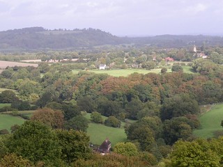
Shoulder of Mutton Hill (steep, fine view) and a very walker friendly pub


| Length |
16.6km (10.3 miles), five hours walking time. For the whole excursion including trains and meals allow 9 hours. Short circular walk of 10km (6.2 miles), three hours walking time. |
|---|---|
| Maps |
OS Landranger 197 & 185. OS Explorer OL33 (formerly 133). |
| Toughness |
5 out of 10 |
| Features |
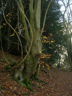
Much of this walk follows the Hangers Way, a long distance path which lies within an area of Outstanding Natural Beauty. The name Hanger derives from the old English "Hangra" meaning a wooded slope. Much of the walk is in unspoilt countryside which remains as it was several hundred years ago. The very steep ascent of Shoulder of Mutton Hill may be slippery in winter when the slightly longer alternative route is advised. Whichever route is taken the view at the top is spectacular. |
| History |
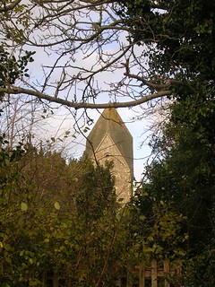
The ancient market town of Petersfield was founded in the early 12th century and later became a coaching centre on the main London to Portsmouth route. At the centre of the market square is a fine equestrian statue of King William III dating from 1753. The village of Steep was the home of first world war poet Edward Thomas who is commemorated by a memorial stone on Shoulder of Mutton Hill. He lived at 2 Yew Tree Cottages along the lane from All Saints' church. He enlisted in the Artists Rifles and was killed at Arras in 1917, aged 39. The clear windows in the south wall of the church were engraved in 1978 by Laurence Whistler in the poet's memory. The church dates back to 1140 and contains an impressive set of embroidered kneelers depicting the natural history of the area. |
| Walk Options |
The length of this walk can be reduced by 5.5km by taking a shortcut at point [6]. From the Hawkley Inn head east along Pococks Lane and continue on a footpath heading north-east to Upland Lane. Turn right onto this road to rejoin the main route between points [8] and [9]. This makes a shorter walk of 11.1km. Shoulder of Mutton Hill makes a fine objective in its own right. The short circular walk allows you to enjoy the spectacular views from its summit on a pleasant half-day stroll. The strenuous climb of Shoulder of Mutton Hill aside, this is a walk of gentle gradients apart from one short steep downhill section which may be slippery in winter. Note: There are no refreshment stops on the short circular walk. Do not take the detour to the Harrow Inn described in the book, as this is along a private road and pedestrian access is not now permitted. Longer option: Petersfield to Alton: the Petersfield to Selborne or Alton pdf link at the top of this page gives instructions to link this walk with Selborne, the lunch stop on Alton Circular walk, also on this website. It is 13.2km (8.2 miles) from Petersfield to Selborne and on Mondays to Fridays you can get bus no 38 from there to Petersfield. Otherwise it is another 10.7km (6.6 miles) to walk on from Selborne to Alton using the afternoon route of the Alton Circular walk, making a total walk from Petersfield of 23.9km (14.8 miles). |
| Saturday Walkers Club |
Two fast trains an hour run from London Waterloo to Petersfield, journey time one hour. Trains back from Liss run hourly. Take the train nearest to 9.45am and buy a day return to Petersfield. |
| By car |
Parking at Petersfield station. Liss is one stop further up the line. |
| Lunch |
The suggested lunch stop is the Hawkley Inn (tel 01730 827205), 6.6km into the walk. The pub has a garden and serves home cooked food until 2pm at weekends. Booking is advised. Short Walk: The suggested lunch stop is the Harrow Inn (tel 01730 262685). This pub with a garden has been described as one of the finest traditional country inns in England dating from the seventeenth century. Alternatively you could take a picnic (Shoulder of Mutton Hill is a good spot). |
| Tea |
In Liss the suggested tea stop is Wine Bar & Coffee House at 41-43 Station Road (tel 01730 892227) which serves cream teas (open to 5pm Monday-Thursday, 10pm Fridays and Saturdays, but closed Sundays). An alternative is the Whistle Stop pub (tel 01730 890464) at the bottom of Hill Brow Road, 150m past the station. At the end of the circular walk it is worth going past the station into Petersfield town centre. There is a good choice of refreshment places around the main square, for example Cloisters Café (open to 6pm Monday-Saturday, 5pm Sundays) and the Square Brewery pub (tel 01730 264291). |
| Book |
This walk was originally published in Time Out Country Walks near London volume 2. We now recommend using this online version as the book is dated. |
|---|---|
| Profile | |
| Help Us! |
After the walk, please leave a comment, it really helps. Thanks! You can also upload photos to the SWC Group on Flickr (upload your photos) and videos to Youtube. This walk's tags are: |
| By Train |
Out (not a train station) Back (not a train station) |
| By Car |
Start GU32 3EE Map Directions Return to the start: Finish GU33 7AA Map Directions Travel to the start: |
| Amazon | |
| Help |
National Rail: 03457 48 49 50 • Traveline (bus times): 0871 200 22 33 (12p/min) • TFL (London) : 0343 222 1234 |
| Version |
Apr-23 DAC |
| Copyright | © Saturday Walkers Club. All Rights Reserved. No commercial use. No copying. No derivatives. Free with attribution for one time non-commercial use only. www.walkingclub.org.uk/site/license.shtml |


Walk Directions
Full directions for this walk are in a PDF file (link above) which you can print, or download on to a Kindle, tablet, or smartphone.
This is just the introduction. This walk's detailed directions are in a PDF available from wwww.walkingclub.org.uk