Pewsey Circular Walk
North Wessex Downs and the Vale of Pewsey
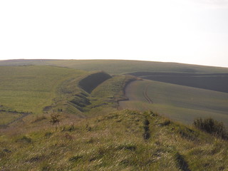
Wandsdyke in the evening sun
SWC Walk 127 Pewsey Circular
Sep-15 • thomasgrabow on Flickr
swcwalks swcwalk127 walkicon banner 21802743532

Westerly Views from Huish Hill
SWC Walk 127 Pewsey Circular
Aug-15 • thomasgrabow on Flickr
walkicon swcwalks swcwalk127 21209246692
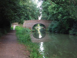
Bridge #115, Kennet & Avon Canal
SWC Walk 127 Pewsey Circular
Aug-15 • thomasgrabow on Flickr
walkicon swcwalks swcwalk127 21226806221

Oare Hill with Giant's Grave
SWC Walk 127 Pewsey Circular
Sep-15 • thomasgrabow on Flickr
walkicon swcwalks swcwalk127 21824188821
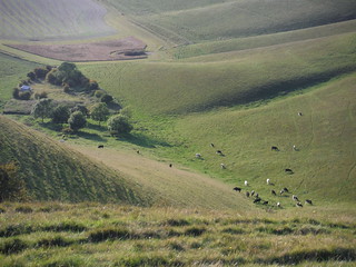
Cows at bottom of Milk Hill
SWC Walk 127 Pewsey Circular
Sep-15 • thomasgrabow on Flickr
walkicon swcwalks swcwalk127 21788356576
| Length | 27.0 km (16.8 miles) with 380m ascent/descent. For a shorter walk see below Walk Options. |
|---|---|
| Toughness | 6 out of 10, with 6 hours walking time. For the whole outing, including trains, sights and meals, allow at least 9 hours. |
| Walk Notes |
This is an exhilarating excursion through the solitude of the Vale of Pewsey, which separates the chalk upland of the North Wessex Downs to the north from that of the Salisbury Plain to the south, including an ascent up the southerly escarpment of the Pewsey Downs, from where there are stunning far views in all directions over this land of wave-like hills, with its scarps, ridges and valleys. It is a mysterious landscape, full of pre-historic earthworks and hillforts as well as barrows – burial mounds of kings and warriors.
Shortcuts reduce the rating of this walk to 4/10 or even 3/10. |
| Walk Options |
Two Shortcuts are possible: they reduce the walk by 3.5 km (2.1 mi) or by 3.4 km (2.1 mi) respectively, the ascent/descent by 73m or 67m respectively and the rating to 4/10 respectively; or to 3/10 when walking both Shortcuts (resulting in a 19.8 km/12.3 mi walk).
|
| Maps | OS Explorer: 157 (Marlborough & Savernake Forest)
|
| Travel |
Pewsey Station, map reference SU 161 603, is 25 km south of Swindon, 116 km west of Charing Cross, 116m above sea level, and in Wiltshire. Pewsey Station is on the Berkshire and Hampshire line, served by Intercity trains between London and the West Country. The journey time is from 59 minutes. Pewsey is outside the Network South East Area, necessitating split journey tickets at either Reading, Newbury or Hungerford if using the Network Railcard. Saturday Walkers' Club: Take any train up to 11.00 hours. |
| Lunch/Tea |
The Honeystreet Mill Café Honeystreet Mill, Pewsey Vale, SN9 5PS (01672 851 853). The Mill Café is located 19.6 km (12.2 mi) into the full walk.
More than a handful of tea options, just off-route in Wilcot and in Pewsey. For details see the walk directions pdf.
|
| Profile | |
|---|---|
| Help Us! |
After the walk, please leave a comment, it really helps. Thanks! You can also upload photos to the SWC Group on Flickr (upload your photos) and videos to Youtube. This walk's tags are: |
| By Train |
Out (not a train station) Back (not a train station) |
| By Car |
Start Map Directions |
| Amazon | |
| Help |
National Rail: 03457 48 49 50 • Traveline (bus times): 0871 200 22 33 (12p/min) • TFL (London) : 0343 222 1234 |
| Version |
Jul-24 Thomas G |
| Copyright | © Saturday Walkers Club. All Rights Reserved. No commercial use. No copying. No derivatives. Free with attribution for one time non-commercial use only. www.walkingclub.org.uk/site/license.shtml |

Walk Directions
Full directions for this walk are in a PDF file (link above) which you can print, or download on to a Kindle, tablet, or smartphone.
This is just the introduction. This walk's detailed directions are in a PDF available from wwww.walkingclub.org.uk