Saunderton via Bledlow Circular walk
The Chilterns: the Ridgeway Path over an open ridge, returning by peaceful and secluded valleys.

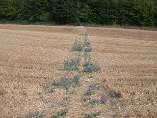
walk 02 Path Through Plouged Field
Aug-03 • Saturday Walkers Club (unknown) on Flickr
swcwalks book2 walk2 37134613376

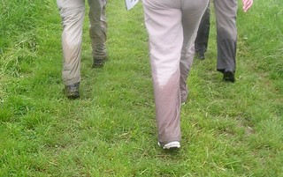
Bledlow Ridge Wet Trouser Competition: finalists
The wet vegetation takes effect. Saunderton circular via Bledlow Ridge
walk2 book2 swcwalks 2543730911
Chinnor Hill & Bledlow Ridge
| Length |
Standard walk: 17.3km (10.7miles), 5 hours 20 minutes. For the whole outing including trains, sights and meals allow 9 hours. Short walk: 9km (5.6miles), 3 hours. |
|---|---|
| Maps |
OS LandRanger Map No. 165. OS Explorer Map Nos. 171, 172 and 181. Chiltern Society Map Nos. 7 and 14. Saunderton (station), map reference SU813 982 is in Buckinghamshire, 16km south of Aylesbury. |
| Toughness |
6 out of 10 |
| Features |
This walk through a peaceful part of the rolling Chiltern Hills has one or two steep hills, but otherwise gradients are gentle and there are many fine views out over the valley and plain. The first part of the walk follows the valley bottom before following the Ridgeway to lunch at Bledlow. In the afternoon you pass through a series of secluded valleys before reaching Radnage and then over Bledlow Ridge and back along the valley to Saunderton. |
| Walk Options |
You may reduce the length of the standard walk by over 8km to 9km (5.6 miles) by following the standard walk directions given until [3].Then follow the short walk directions and then pick up the standard walk directions at [8]. Varying the walk You may combine the Saunderton North short walk with the Saunderton South short walk for a 18.3km (11.4 miles) walk. This walk takes the form of a figure of 8. With plenty of refreshment stops along the way, you may choose to start with the Saunderton North or the Saunderton South walk. Lengthening the walk You may increase the length of this walk by over 9km to 26.9km (16.7 miles) by combining it with the Saunderton South short walk. For the more ambitious, the walk may be lengthened by over 18km to 33.3km (20.7 miles) by combining it with the Saunderton South standard walk. Both of these longer walks take the form of a figure of 8. With plenty of refreshment stops along the way, you may choose to start with the Saunderton South or the Saunderton North walk. Directions for a Saunderton to Princes Risborough walk: 13km (8.1 miles). These directions in combination with a pre lunch section of the standard walk provide a linear walk from Saunderton to Princes Risborough. |
| History |
The Parish Church of Holy Trinity,Bledlow, dates from the 12th century. The nave is believed to be part of the original church, which probably once had transepts and a central tower. Of special interest are the nave arcades, which are fine examples of early 13th century work and also the 14th century windows. There are some interesting remains of medieval mural paintings in the north aisle, particularly that of St. Christopher. Lyde Gardens,Bledlow, are well worth a visit at any time of the year and may be entered through a gate on Church End immediately east of the churchyard. From the east side of the churchyard you can look down into the Lyde where water from eight springs emerge. The closeness of Holy Trinity Church to the steep banks of the coombe resulted in the local proverb: 'They that live and do abide shall see the church fall in the Lyde.' St Mary's Church, Radnage was built largely during the 13th century. The church tower is original and is about 3 metres square and of a style which has elements of the late Norman and early English periods. The nave probably dates from the late 13th century and is thus probably a later addition to the original building. It is decorated with wall paintings, which span six centuries. The porch was added in the 15th century and has a fine perpendicular arch above the door. |
| Saturday Walkers Club |
Take the train nearest to 10.10am (before or after) from Marylebone station to Saunderton. Journey time is 47 minutes. Trains back from Saunderton run once an hour. |
| By car |
There is a car park (currently free) at Saunderton Station. |
| Lunch |
Standard walk The suggested lunchtime place is the Lions (tel 01844 343345), Church End, Bledlow, 7km from the start of the walk, which serves good food from 12 to 2.30pm daily and has an extensive garden. Short walk (5.25km from the start of the walk) / Standard walk (4km from the end of the walk) late alternate. The Boot (tel 01494 481499), Chinnor Rd, Bledlow Ridge, which serves good food from 12 to 2pm daily. Picnic Virtually anywhere along the route would be a good picnic spot. |
| Tea |
The suggested tea place is the Golden Cross (tel 01494 565974), close to the Saunderton station which offers tea and coffee. It is open daily. |
| Book |
This walk was originally published in Time Out Country Walks near London volume 2. We now recommend using this online version as the book is dated. |
|---|---|
| Profile | |
| Help Us! |
After the walk, please leave a comment, it really helps. Thanks! You can also upload photos to the SWC Group on Flickr (upload your photos) and videos to Youtube. This walk's tags are: |
| By Train |
Out (not a train station) Back (not a train station) |
| By Car |
Start HP14 4LJ Map Directions |
| Amazon | |
| Help |
National Rail: 03457 48 49 50 • Traveline (bus times): 0871 200 22 33 (12p/min) • TFL (London) : 0343 222 1234 |
| Version |
Apr-24 DAC |
| Copyright | © Saturday Walkers Club. All Rights Reserved. No commercial use. No copying. No derivatives. Free with attribution for one time non-commercial use only. www.walkingclub.org.uk/site/license.shtml |


Walk Directions
Full directions for this walk are in a PDF file (link above) which you can print, or download on to a Kindle, tablet, or smartphone.
This is just the introduction. This walk's detailed directions are in a PDF available from wwww.walkingclub.org.uk