Shiplake to Henley Walk
The River Thames, Rotherfield Greys village, Greys Court (NT) and historic Henley

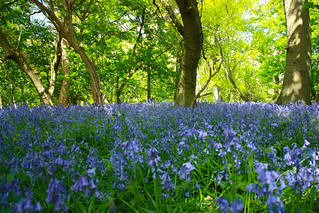
bluebells woods
bluebells flora book1 henley shiplake walk9 walkicon 450d swcwalks 3481640970
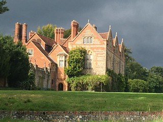
Grey's Court
Shiplake to Henley. It's Tudor, innit. The impending storm stayed away.
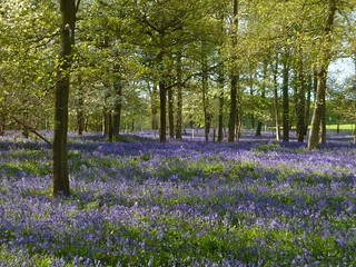
swcwalks book1 walk9 chilterns walkicon 50327130523

River Thames, Rotherfield Greys & Greys Court
| Length |
17.96km (11.16 miles), 5 hours. For the whole outing, including trains, sights and meals, allow 9 hours. |
|---|---|
| Toughness |
4 out of 10. |
| OS Maps |
Explorer 171 or Landranger 175. Shiplake, map reference SU 776 797, is in Oxfordshire, 9km north- east of Reading. |
| Features |
This walk has plenty of variety, with riverside legs and paths through bluebell woods and beech woods. In addition, as soon as you are more than a few feet up, you have magnificent views over the unspoilt Thames valley. From Shiplake Lock the route follows the Thames, then up to the church beside Shiplake College, and through bluebell woods beside Crowsley Park (the grandiose site for the BBC’s listening masts), to the church and pub in Rotherfield Greys. The cherry trees and cricket green in the hamlet of Greys Green lead on into the National Trust estate of Greys Court, and from there into the beech woods of Lambridge, and past Friar Park, with its splendidly over-opulent Gothic gatehouse, to a teahouse in Henley beside the river. Note that if there has been sustained heavy rain the river may be flooded and make the first stretch along the river in the main walk route impassable. |
| Walk Options |
During bluebell season, you can take an alternative route from Shiplake to High Wood, with its carpets of bluebells, to rejoin the main walk at Binfield Heath by the Bottle & Glass Inn. This shortens the length of the main walk by 3km. Also during bluebell season you can take an alternative route late morning which goes past a number of private bluebell woods to the Maltsters Arms pub and avoids some 400 metres of road walking into the village of Rotherfield Greys - directions are shown after the other walk options. This adds a few hundred metres to the walk length. Those that enjoy a leisurely amble along a riverside tow path can take the Lashbrook Thames tow path route shortly after the start of the walk (see History below) as a prelude to your riverside leg which starts at Shiplake Lock: the Lashbrook loop adds just over 1km to the length of the walk. After lunch at the Maltsters Arms pub in Rotherfield Greys, you could take a direct footpath to Henley (see the asterisk [*] in the book’s walk directions), and so avoid the extra 4km involved in visiting Greys Court; or you could call a taxi from either of the lunchtime pubs. You can extend the main walk at walk-end by returning to Shiplake from Henley, making this a circular walk, by following the Thames path: this pleasant leg (especially for those that take the High Wood option which misses out on a riverside leg) adds 3.5km to the length of your walk. But Note Marsh Head Horsebridge footbridge (just south of Henley) has been closed on safety grounds by the Environment Agency and is likely to remain closed for the remainder of 2023. A diversion inland is in place on a permissive path over private farmland before you return to the Thames path. |
| History |
Shiplake was as close as the Vikings could get their ships to their main encampment in Reading - hence, possibly, the name 'Ship lack'. There were vineyards on the riverside slopes during Tudor and Stuart times. Shiplake College was built in the 1890s by a stockbroker; it was used by the BBC in World War II; and became a school in 1959. Shiplake Church dates from the eleventh century and contains stained glass from the Abbey of St Omer in France. The poet Tennyson was married here in 1850 - he wrote: 'The Peace of God came into my life before the altar when I wedded her.' Four times a week Shiplake College uses the church for its assemblies. St Nicholas Church in Rotherfield Greys contains the ornate tomb of Robert Knollys, Elizabeth I's treasurer who took charge of Mary Queen of Scots during her imprisonment; and of Robert's wife Katherine, a first cousin to Elizabeth I; and the effigies of their 16 children. The church curate reported in 1738 that, so poor were his parishioners, of the 'Absenters from ye Church there are a great many yet come but seldom [for] want of clothes'. Whilst the church's Revd J Ingram wrote of his experiment in 1823 to create jobs by cultivating opium: 'From its purity it was found of superior efficacy to that bought from Turkey or the East Indies, and I obtained a high price for it from the Society of Apothecaries Hall.' Greys Court (tel 01491 628 529), owned by the National Trust, is a sixteenth-century house of brick, flint and stone, erected in the ruins of a vast mansion that was castellated by the first Lord Grey in 1347 - with a licence from Edward III, in recognition of loyal service at the Battle of Crecy. Until recently the house was the home of Lady Brunner, a granddaughter of the actor Sir Henry Irving. The estate has a maze, two possibly Tudor towers, ruins and a large donkey wheel and horse wheel that were used for pumping up water. Opening times vary during the year but in general, in winter the house is open 11am-3pm and the gardens and Tea Room (10am-4pm), and in summer the house is open 1pm-5pm, gardens and tea room 10am-5pm. Admission (free for NT Members) for 2023 is £14.00, with a free cup of tea for walkers and cyclists. Henley, with its 300 listed buildings, is said to be the oldest settlement in Oxfordshire. Lashbrook Loop. This section of the Thames Path, around a meander in the river, re-opened in 2012 after a 17 year legal battle with local land owners. The Ramblers Association was responsible for the re-opening of this riverside route and they encourage walkers to use it. |
| Travel |
For the main walk, with or without riverside options, and if planning to take lunch at the Maltsters Arms, take a train between 9am and 9.30am from Paddington Station to Shiplake, changing at Twyford. Journey time 1 hour. Otherwise, if planning to take lunch at the Bottle & Glass Inn on the main route (re-opened April 2017) or after following the High Wood route, take the train leaving Paddington nearest to 10-30am. Trains back from Henley Station are hourly. Journey time 65 minutes. Buy a day return to Henley-on-Thames. Consider taking an earlier train that the timetable suggests, its an hour wait if you miss the connection at Twyford. Rail ticket: Now that Elizabeth Line trains are running between Paddington and Reading, if you are one of our senior walkers who holds a Freedom Pass you can travel free of charge on these TFL trains (blue livery) as far as Twyford, leaving you to purchase a day return from Twyford to Henley. However , if you travel on a Great Western train (green livery) you will need an off-peak day return from the edge of your travel card (Zone 6) to Henley. |
| Lunch |
The suggested lunchtime pub on this walk is the Maltsters Arms (tel 01491 629974) in Rotherfield Greys. This lovely pub, which reopened after refurbishment and a with a new tenant in June 2022, has been a long term friend of SWC walkers. In addition to two comfy indoor areas it has a part-covered rear outside patio and rear open garden. Latest information on website on opening times etc is 2024: Lunch is served on Monday, Thursday and Friday from 12 noon until 2.30 pm, on Saturday until 3 pm and on Sunday until 4 pm (two separate sittings). No food is served at lunchtime on Tuesday and the pub is closed on Wednesdays. Booking ahead on Sundays is essential. The suggested alternative, 4km earlier in the walk is the thatched pub in Binfield Heath called the Bottle & Glass Inn (tel 01491 412625). As of 2025, the pub is closed on Mondays and Tuesdays. On Wednesday to Saturday, lunch is served in its inside restaurant and large, pleasant outdoor garden from 12 noon to 3 pm, and on Sundays from 12 noon to 4 pm. The pub's large barn is open for brunch on Wednesday to Friday from 9 am until 3 pm, and at weekends lunch is served between 12 noon and 4 pm. |
| Tea |
For an early tea, Greys Court NT (entrance fee for non-members), has a Tea Room with free cup of tea for walkers. The suggested tea place at walk end is the newly renamed cafe (since April 2025) Viv's [formerly the Chocolate Café and before that the Chocolate Theatre Cafe and before that the Henley Tea Rooms], same owners and same 'phone number (just a change of name) (tel 01491 411 412) on Thameside (Street), facing the river (open Monday to Friday to 5pm, weekends to 6pm). They have an outdoor sitting area beside the river which is pleasant in summer. The railway station is 5 minutes walk away. In summer the church of St Mary the Virgin serves teas on a Sunday. The Red Lion Hotel serves cream teas. There are also a large number of pubs in Henley for those in need of a stronger drink. For those returning along the Thames path to Shiplake, refreshments can be taken at the Baskerville pub-restaurant (0118 940 3332), very close to the railway station. |
| Updates |
Web version has several recent options (Bluebell wood, a riverside loop, return to Shiplake via the Thames Path). Pre 2011 editions - use the online version. Last book check and walk update (High Wood route) April 2024 and main route April 2025. Pub opening update April 2025. |
| Book |
This walk was originally published in Time Out Country Walks near London volume 1. We now recommend using this online version as the book is dated. The book contained 53 walks, 1 for every week of the year and 1 to spare. Here is our suggested schedule |
|---|---|
| Profile | |
| Help Us! |
After the walk, please leave a comment, it really helps. Thanks! You can also upload photos to the SWC Group on Flickr (upload your photos) and videos to Youtube. This walk's tags are: |
| By Train |
Out (not a train station) Back (not a train station) |
| By Car |
Start Map Directions Return to the start: Finish Map Directions Travel to the start: |
| Amazon | |
| Help |
National Rail: 03457 48 49 50 • Traveline (bus times): 0871 200 22 33 (12p/min) • TFL (London) : 0343 222 1234 |
| Version |
Apr-25 Marcus |
| Copyright | © Saturday Walkers Club. All Rights Reserved. No commercial use. No copying. No derivatives. Free with attribution for one time non-commercial use only. www.walkingclub.org.uk/site/license.shtml |


Walk Directions
- [1] At Shiplake Railway Station, you have a choice. Either follow the main route, or take the High Wood option (a shortcut through a pretty bluebell wood) that saves 3km.
- To follow the High Wood Option: Follow the directions below at the end of the Main Directions.
- For the main walk route, coming off the train at the single platform Shiplake Railway Station, you head left towards the end of the platform (away from Henley) and go down steps with yellow painted railings, your direction 250 °. In 3 metres go through a white painted wooden swing gate and keep straight ahead on a gravel path. In 85 metres turn left on a tarmac residential road (Mill Road), your direction 160°.
- Keep ahead along Mill Road and in 200 metres, just before you reach New Road on your right, you come on your right-hand side to a footpath sign “to the river” on a lamp post, and a two-armed wooden footpath sign "Thames Path", both pointing to your left.
- Here you have a choice, the Lashbrook Loop which follows a meander (loop) of the Thames Path, or the main route which cuts off the loop, and is shorter.
- To follow the Lashbrook Loop: Follow the directions below at the end of the main walk directions.
- For the main walk, continue ahead along Mill Road. In 225 metres, by a brick postbox, take a road to the left , marked Lashbrook House Care Home (with Crowsley Road going off to the right), your direction 120°. In 15 metres, go over a stream on a bridge with red brick walls and in a further 20 metres, turn right on a footpath signposted "To Shiplake Lock", your direction 165°, down earthen steps and through a metal kissing gate.
- Cross a grassy field and in 45 metres go through another metal kissing gate, pass through a field boundary and bear right onto a path along the right-hand edge of a field, with a post and wire fence on your right-hand side, your direction now 190°. In 150 metres cross a gravel track and keep ahead now on an enclosed path, with pine trees to your left and a post and 3 strand barbed wire fence on your right. In 50 metres you reach a gravel road, opposite Mill House, where you go right, your direction 250°.
- [1A] (The Lashbrook Loop option rejoins here) In 20 metres turn left onto a tarmac path, with a high flint wall to your left, following a two-armed footpath sign "Thames Path", your direction 195°.
- In 35 metres, just before a footbridge, and by a three-armed Thames Path sign, go through a metal kissing gate on your right-hand side, with Shiplake Lock and the River Thames on your left-hand side, your direction 245°, onto a grassy way, with a post and wire fence on your right with a grassy field beyond.
- In 230 metres go through a field boundary and continue ahead, still with the River Thames on your left-hand side. In a further 350 metres you go through a metal kissing gate in a field boundary and continue along the edge of the river, now with a tall hedge on the right-hand side. In 150 metres go over a wooden bridge made of six railway sleepers with wooden handrails.
- In 150 metres you come out to a grassy open space, with Shiplake College banner signs at either end and with a concrete footbridge with wooden handrails ahead [2]. Keep ahead over the grass and in 40 metres, just before the footbridge, [!] you bear right over the gravel forecourt to Shiplake College Rowing Club and bear left onto a gravel track, passing a boathouse building on your left, with a four bay brick boathouse with an upper storey on your right-hand side, your direction 240° (chalk cliffs are 50 metres away on your right-hand side).
- In 90 metres at a track junction, by a blue arrow on a post, [!] turn right uphill on a bridleway, your direction 10°. Head up this bridleway, quite steeply in places, in a woodland strip, soon with the occasional concrete step.
- In 150 metres, at the top of the slope, you enter the churchyard of Shiplake Church through a pair of wooden swing gates, with Shiplake College off to your right. After looking around the church turn right out of the church door, leaving the churchyard through a different pair of wooden swing gates beside a large cedar of Lebanon tree, coming out onto a lane.
- Turn right on the car lane (Church Lane), your direction 310°. In 250 metres cross the A4155, slightly to the left, to continue on Plough Lane, passing on your left-hand side The Plow, Shiplake pub (formerly the Plowden Arms pub ) in new ownership after a few years of closure, and newly refurbished. If open when you pass it can serve as an elevenses stop.
- In 200 metres go left on a signposted footpath, with sign to Shiplake Farm, your direction 230° (a concrete road).
- In 40 metres do not veer left with the concrete road but go straight on, past a redundant metal kissing gate with a metal vehicular barrier to its left, to cross a farm track and keep ahead, steadily uphill, on a grassy strip between agricultural fields, with a post and wire fence on your left-hand side, your direction 240°.
- In 350 metres at the end of the field, go through the field boundary, and by a round wooden post with yellow arrows, immediately turn right , now with the field fence on your right-hand side, your direction 305°.
- In 150 metres you come to the end of the field. There is a wooden marker post to your right. Turn left and follow the edge of the field for 75 metres, towards a small copse. At the entrance to the copse, by a footpath sign with a yellow arrow, turn right over the large open agricultural field now ahead of you on a diagonal in a northerly direction towards a cluster of three houses. Note After the harvest and ploughing the farmer does not always reinstate this path. At other times of the year he does. In 200 metres at the far side of the field, veer right along the field edge, keeping the fence on your left, until in 65 metres you reach a road [3]. On your left-hand side is Orwells restaurant (formerly the White Hart pub), but this is not the lunchtime stop.
- Cross the road, slightly to the right, and pick up the signposted footpath to the right of Waylands House, your direction 5°, and follow a line of telegraph poles, gently uphill, with a hedge on your left and an agricultural field to your right.
- In 170 metres you come to an earth car road (Kiln Lane) by a bungalow, where you go left, your direction 260°.
- Keep ahead along this lane, ignoring all turnings off, at times with woodland on either side, at times with fields. After you pass the turning to New Road on your left, the earth car road becomes tarmac. Some 760 metres along Kiln Lane from the start, you come to a car T-junction, at which you turn right, your direction 350°.
- In 650 metres you come to the Bottle & Glass Inn in Binfield Heath, your early lunchtime stop option with a pleasant pub garden: the later stop – the Maltsters Arms - is still 4km away.
- [3A] Go past the pub (on your right) over its gravel forecourt onto a car-wide gravel track. In 40 metres ignore a right-hand turn into a farmyard and take the lesser path, continuing straight on, your direction 290°. At times this path, between trees and bushes, has a wood chip surface, giving it a pleasant, soft footbed. Keep ahead on this path, gently uphill.
- In 350 metres the path swings in a gradual arc to the right. In a further 100 metres at a path junction [4], by a post on your left with a blue arrow left and a yellow arrow right [!], follow the blue bridleway arrow to the left, down into the wood, your direction 295°. Keep to the main path.
- Ignore all turnings off and follow occasional white arrows on trees pointing ahead as the bridleway descends in light woodland. In 350 metres you cross an earth car-wide track marked with a ‘No horses’ sign. The bridleway soon swings slightly to the right and it levels out before narrowing and starting to go steeply uphill, through woodland, your bearing now 300°. In 200 metres you reach the battered iron railings of the BBC’s Crowsley Park (with listening masts) on your left-hand side and you bear right, your direction now 345°.
- Ignoring ways off, with the vast grounds of Crowsley Park to your left and woodland to your right. In 300 metres you cross the drive to Keeper’s Cottage and you keep ahead, now downhill, through woodland. In a further 250 metres, the path comes down to a car road, where you turn left, your direction 255°.
- In 60 metres you pass a timber-framed mansion, Old Place (marked on the OS map), on your right-hand side, then take the tarmac road right at the end of the building, signed The Chiltern Way Extension, your direction 355°, uphill. In 85 metres, with the vehicular double gated entrance to Old Place on your right, bear left with the road, still steadily uphill, your direction 320°.
- Ignore all ways off and in 550 metres, by Kingsfield House, ignore a footpath sign off to the left. In a further 100 metres, with Kings Farm on your left [!] you have a choice of onward route . For the alternative route to the Maltsters Arms pub in Rotherfield Greys, see the directions after the other walk options. This route is slightly longer - by a few hundred metres - than the main route. Otherwise, the main route continues as follows: just before the road veers left, [!] take the path to the right of two cottages, following the footpath sign, and go over a stile (a metal fieldgate to its left), your direction 80°, on an earth car-wide road.
- [!] In 35 metres, by the back of a garage, by a concealed yellow arrow on a post, go left over a stile [5] and straight on, your direction 20°, on an enclosed path between fences.
- In 135 metres cross stiles on either side of a farm access road and keep ahead on a grassy way between fences. In a further 200 metres leave the paddocks up a slight bank and through a line of trees and go straight on across open fields, on a fenced-in grassy path.
- In 150 metres keep ahead, now with a wire fence only on your left-hand side. In a further 150 metres keep ahead now again between fences, with a new plantation of trees to your right. In 175 metres go through a gap where there was once a wooden fieldgate onto a worn tarmac road with Cowfields Farm (so marked on the OS map) on your right-hand side.
- In 75 metres, as the road swings to the right, [!] follow the yellow arrow half left, your direction 325°, on an earth way across the field (the right-hand of two paths across this field), heading slightly to the right of St Nicholas Church, which is just visible in the distance. In 350 metres exit the field through a new metal kissing gate to come out on to a small road. Cross it and in 10 metres you reach a larger road T-junction, where you turn left, your direction 290° (you can just see Greys Court House 1.5km ahead of you, at 340°).
- In 150 metres you pass on your left the entrance to a Woodland Natural Burial Ground. In a further 240 metres you come to St Nicholas Church in Rotherfield Greys and, 35 metres beyond the church, the Maltsters Arms, the suggested lunchtime stop.
- Coming out of the pub door after lunch, turn right and, a little beyond the church, just after a bus stop on the left , turn left through a wooden kissing gate.
- Here you have a choice. To take the short cut back to Henley mentioned in the introduction [*] take the right-hand footpath signposted to Henley, and follow the Shortcut from Rotherfield Greys to Henley directions below.
- For the main walk take the left-hand footpath, your direction 20°.
- In 135 metres go over a stile and straight on into a wood, following a clear path, downhill, your direction 35°.
- In 170 metres exit the wood over a stile and turn left, your direction 305°, and walk with the edge of the wood on your left-hand side, gently uphill.
- In 120 metres you pass a stile with an ex-vicarage on your left-hand side. In 80 metres go through a wooden kissing gate into woodland . The path winds uphill and in a further 120 metres you come out to a minor car road [6], where you turn left, due south, in 35 metres passing Green Place House on your right-hand side. 60 metres beyond the house’s driveway, at a T-junction, go right, your direction 295°.
- In 125 metres, by a war memorial, you join a more major road lined with cherry trees. Cross the road and bear left along the wide, tree-lined grassy verge, following the signpost direction to Nettlebed, your direction west.
- In 240 metres you pass Rotherfield Greys village hall on your left-hand side. 20 metres beyond the village hall turn right onto an earth car road, with a signpost to Greys Court, due north, with a cricket green on your left-hand side.
- In 70 metres, turn left in front of a row of cottages and at their further end pick up a signposted footpath The Chiltern Way Extension to the right, your direction 65°. In 80 metres you head down into a wood on a clear path.
- In 50 metres go through a wooden swing gate and descend steeply . In 60 metres exit the wood through a wooden swing gate and go straight on across a grassy field, downhill to a dip, then uphill, your direction 45°, towards Greys Court, in winter visible across the valley. In 80 metres go through a wooden kissing gate to leave the field. In 5 metres cross a tarmac lane and keep ahead and in 15 metres you go through a wooden swing gate to enter the Greys Court estate, your direction 55°.
- In 40 metres join a tarmac drive to go straight on, steadily uphill. In 160 metres, you pass the manor house on your left-hand side (with some of the medieval ruins visible to its right). In a further 140 metres you pass the visitor site hut and ticket kiosk.
- If you plan to visit the manor house and or its extensive bluebell paddock in season, check in at the ticket kiosk then return down the road to the main entrance to Greys Court. For the bluebells, head down the clear path within the estate, and after visiting the bluebells, return uphill to the main entrance. Note there is no longer access to the bluebell paddock from the public footpath beyond Johnnies Gate.
- Back at the ticket kiosk, [!]bear left off the entrance drive to go along the left-hand side of the visitor car park. At its far end go through two wooden bollards to head down the left-hand side of a field towards “Johnnies Gate”.
- In 110 metres go through this wooden gate and continue ahead. In season you now have a view on your left-hand side of Grey Court's magnificent bluebells - but no access to them, as noted above. In 60 metres go through another wooden swing gate on your left-hand side and continue ahead, in the same direction as before.
- In 25 metres go over a wooden bridge structure with a wooden railing and a pond on the right-hand side. In 70 metres go through a wooden swing gate and turn left, in 5 metres going through another wooden swing gate (with a metal fieldgate on its left-hand side and a farm shed ahead of it) to go right, and continue in your previous direction, 50°, with the fence on your right-hand side.
- In 130 metres you come to a tarmac lane and ignore the two sets of onward footpath arrows visible [7], then turn right downhill on a lane, your direction 105°.
- In 55 metres you come to a tarmac road T-junction by Broadplat Croft, where you turn left uphill and, in 10 metres, by a footpath sign for Lower Assenden, pass through a wooden kissing gate with a metal fieldgate on its right, on to a clear, broad path into the beech wood marked on the OS map as Lambridge Wood, a SSSI woodland, your direction 55°, gently downhill.
- Follow white arrows on the trees - repainted 2024, and marker posts with yellow arrows. In 290 metres you have the start of open fields visible off to your right-hand side (you remain in the wood, parallel to the fields ).
- In 200 metres, when you come to the end of these fields on your right-hand side, veer right, slightly downhill, on a path that keeps roughly along the right-hand edge of the woods, with the top edge of the fields 10 to 15 metres to your right, your direction 100 degrees.
- Follow this path down the wood edge, ignoring ways off, and when given a choice of paths, keep to the right-hand most path closest to the wood's edge. You no longer have helpful white arrows on trees on this leg, but so long as you keep the wood edge in sight on your right you should remain on the correct route.
- In 400 metres there is another field corner to your right. Bear right just beyond this onto a car-wide path going downhill, still with the wood edge a short distance to your right, your direction now 130°.
- Follow this down into a dip, where there is a marker post with yellow arrows, then up the other side, then along level ground on a way which meanders through the wood. The white arrows painted on trees return as do intermittent marker posts with yellow arrows, to keep you on route. In some 550 metres, exit the wood through a wooden swing gate onto a golf course. Go straight on across this, veering slightly right towards a line of trees, and then following them, with the trees on your right hand side.
- Follow the posts with yellow directional arrows across the golf course, latterly on a gravel path, for a total of some 500 metres. Just beyond Tee 16 on your right-hand side bear left and head towards a stile (with a wooden fieldgate to its right) and in 150 metres you cross it, to go straight on, along a tarmac lane with brick bands , your direction 105 °.
- In 60 metres pass a redundant stile, go through gate posts and keep straight on. In 45 metres you join a tarmac road coming in from the left, to go through open gates between pillars (or cross the stile to their right) and in 70 metres you pass the entrance to Lambridge House on the left-hand side.
- In a further 80 metres you pass a folly, (The Temple), screened by fences on your right-hand side. In a further 200 metres you come to the rebuilt Croft Cottage on your left-hand side [10], where you turn left as the road bends to the right, onto a signposted footpath, your direction 80°, downhill (The house where George Harrison used to live, Friar Park, is on the other side of the high fence topped with razor wire to your right.)
- In 200 metres you come down to a housing estate road (Crisp Road), where you turn right, your direction 120°. In 165 metres turn right uphill into Hop Gardens.
- In 400 metres you come almost to the main road T-junction. Just to your right is the Victorian Gothic splendour of Friar Park’s lodge house. Turn left onto the minor road, 5 metres before the main road (West Street), which has a one-way sign, your direction due east.
- In 120 metres you pass the Row Barge pub on your right-hand side, and keep on, downhill, heading for the church, crossing the main road junction with Kings Road, down the pedestrianised Market Place and crossing Bell Street. Just beyond the church of St Mary the Virgin, with the Red Lion Hotel on your left, turn right on Thameside along the riverfront. In 50 metres you reach Viv's Cafe (formerly known as The Chocolate Cafe, before that the Chocolate Theatre Café, and originally the Henley Tearooms) on your right-hand side, the suggested tea place. After tea, coming out of the café, turn right, pass Friday Street on your right-hand side and keep ahead along the riverfront, coming in 100 metres to the Boats for Hire office
- For the circular walk back to Shiplake Option: Follow the well signposted Thames Path back to Shiplake. It follows the river for 2.5 km, then veers inland along a quiet road for the last 1.2 km to Shiplake Station.
- To continue to the station, bend right with the road, taking the second left to Henley Station by the Imperial Hotel.
The Lashbrook Loop Option
- [!] Turn left if you are taking the Lashbrook Loop. Follow the signpost down a path beside Virginia Cottage, initially on a gravel drive, your direction due east. In 70 metres head down a path between fences, cross a 6 plank bridge with a wooden railing, and swing left with the path, through lightly wooded rough ground
- In 70 metres bear right to duck under the railway (clearance about 5 ft) to go through a metal kissing gate. Now head across an open field, your direction east, in 100 metres to bear left to cross a wooden footbridge with metal railings and with metal swing gates at either end. In 110 metres go through a metal swing gate to turn right on a grassy path beside the River Thames – the Thames Towpath. This is the site of the former Lashbrook Ferry.
- Follow the towpath in its loop beside the river, with open fields on your right-hand side. In 250 metres you cross a wood plank bridge. Continue past moorings. In a further 550 metres, just before the path swings more sharply to the right, and with steps down on your left to a river crossing with the George & Dragon pub on the opposite bank of the river, you come to a metal swing gate on your right-hand side.
- [!] Here you have a choice of route – the Inland Route, or the riverside Back Garden Route.
- To follow the riverside Back Garden Route: This route continues along the river tow path for a further 430 metres. Now go under the railway bridge (this time with ample head room of 3 metres) and shortly ahead you come to a high wooden gate, with a polite notice on behalf of the 12 property owners with gardens leading down to the river. The notice tries to discourage you from following the footpath through their back gardens, suggesting instead you take the path immediately to your right, parallel to the railway above you, to meet up with the Inland Route. However, the property owners do acknowledge the route beside the river and through their back gardens is a public right of way, and the public has the right to walk through their gardens if they choose to do so. The notice concludes by wishing you an enjoyable days walking, whichever route you take! If you opt to continue on this route, go through the high gate, and now cross the bottom of the gardens of the 12 properties, going through a series of wooden gates in the boundary fences of the respective properties. When walking along the bottom of the gardens please respect the privacy of the owners by not lingering en-route or stopping to take photographs and please do not diverge from the official path. You will know when you enter the garden of the twelfth, and final property – No 1 Rivermead Cottages – by the sign on its gate with a green arrow pointing you to the right. Here turn right up the right-hand boundary fence of this garden, to exit the property through a gate to come out on to a private road. Turn left on this road, and in 70 metres you rejoin the main walk route near Mill House by Shiplake Lock, at point 1A.
- To follow the The Inland Route: Turn right through the metal swing gate on a Byway and continue across a field, heading away from the river, your direction due west, with a wire fence on your right-hand side. In 400 metres, at the far side of the field, bear left down a gravel drive to pass to the right of a metal fieldgate. Now go under the railway (again with ample headroom) and keep ahead along a private road, which passes the fronts of the 12 properties whose back gardens extend down to the river. In 300 metres rejoin the main walk route near Mill House by Shiplake Lock, at point 1A.
The High Wood Option
- Coming off the train, turn right towards the end of the platform, to go down steps to walk through the station car park, turning left on Station Road.
- On Station Road, in 45 metres you pass the Baskerville pub-restaurant on your left-hand side. In a further 20 metres, with a corner shop and Post Office on your right-hand side, turn right on Northfield Avenue, in the direction of the footpath sign.
- Keep ahead along Northfield Avenue, passing large residential properties on either side, and in 400 metres, at the end of this road, keep ahead through a metal kissing gate onto a fenced-in footpath between horse paddocks.
- In 250 metres go through another metal kissing gate and cross a main road (the A 4155) to take the path ahead, your direction 260°, along a quiet lane.
- In 600 metres you cross a lane (Woodlands Road) and keep ahead, in a westerly direction, along a quiet private road on a bridleway towards Mays Green.
- In 600 metres the lane dog-legs right around Upper Bolney House and continues ahead, in your previous direction. Pass a large wooden barn and ignore a footpath and stile on your right-hand side.
- In 100 metres ignore a track which veers off to your right and keep ahead, to pass High Wood house on your left-hand side.
- On entering High Wood, you come to a pole in front of you, with three arrows – white, yellow and blue. Bear to the right in the direction south-west of the blue Chiltern Way arrow, and continue ahead on this path in a south-westerly direction through the Wood, with its carpets of bluebells on either side: the bluebell display to your right is particularly stunning.
- In 585 metres you exit High Wood onto a car road, where you turn left , to follow the road gently downhill for 475 metres until you come to the Bottle & Glass Inn on your right-hand side, where you rejoin the main walk route at point 3A.
Shortcut from Rotherfield Greys to Henley Option
- Take the right-hand path on a grassy way, signposted "Henley 2.50 (miles)", your initial direction 65 degrees.
- In 130 metres go through a field boundary, with the edge of a wood on your left and a fenceline to your right. The grassy path soon descends as the hillside slopes down to your left.
- In 310 metres at the bottom of the slope the path swings to the right , and in a further 70 metres, with a fieldgate ahead, turn left through a treeline and descend to cross a stile, where you turn right , your direction 100 degrees.
- In 45 metres cross a stile to the right of a metal fieldgate and keep ahead, in a valley, on a grassy way, along the right-hand edge of a field.
- In 250 metres cross a stile, descend to a track and turn left , your direction 85 degrees, along the left-hand edge of a field with a tree line and bushes on your left. In 115 metres the tree line ends and you keep ahead along the valley bottom, on a grassy way.
- In 260 metres cross an earth track and keep ahead, slightly left, now on a little used earth farm track, with light woodland to your left. In a further 200 metres, as the track swings to the left into Hernes Farm, keep ahead , cross a stile to the right of a metal fieldgate and keep ahead over an often muddy section which meanders through trees.
- In 85 metres cross a stile in the fenceline to follow a fenced-in path, your direction 85 degrees, along a valley bottom. In 600 metres pass to the right of a redundant stile in a field boundary, cross over a path and keep ahead, slightly left, your direction 140 degrees, with a picnic area and Henley Woodland Memorial Ground to your right.
- Follow the fenced-in path, with woodland to your left, and a fence then an open field to your right. In 100 metres you reach the start of Henley College’s sports fields on your left-hand side and in a further 325 metres the path swings to the left to pass tennis courts over to your left.
- In 55 metres go through a rusty metal swing gate and in 70 metres cross a residential road to take a tarmac path ahead, gently uphill, your direction 60 degrees.
- In 250 metres, on reaching concrete steps up into the grounds of Henley College [!] take the dirt path ahead (right of the steps), uphill, with a high wooden fence to your right.
- In 160 metres you come out at a T-junction with a surfaced road, with Lower Lodge House on your left-hand side. Keep ahead on the pavement and in 150 metres, at another T-junction, bear left on Paradise Road and in 65 metres, opposite Friar Park, turn right down Gravel Hill into the centre of Henley . Now refer to paras 59 to 62 in the Main Directions.
Alternative route to the Maltsters Arms pub
- With Kings Farm on your left, swing left with the road, which is now a gravel car-wide track, your direction 330°,initially uphill. Pass Flowercroft Farm on your left. You soon have a bush and treeline strip on your right and a timber fence to your left.
- In 375 metres pass a permitted access gate to Flowercroft Wood on your left. In a further 100 metres your way swings to the left. There are now open fields to your right beyond the treeline, with bluebell woods to your left.
- In 200 metres you pass a "Private Woodland" sign and metal fieldgate to your left. In a further 220 metres you pass Cross Lanes farm on your right and in 50 metres a farmhouse on your left.
- Keep ahead, now on a tarmac farm lane. In 190 metres, as the lane swings to the right, cross over Dog Lane at a major path crossing and take the path immediately ahead, marked "The Chiltern Way bridleway", going past a wooden gate, into a pleasant woodland strip, with open fields beyond on either side, your direction 10°.
- In 180 metres [!] turn right through a metal kissing gate on a path over a grassy field, your direction east. In 120 metres go through a gap in the boundary treeline ahead to pass through "Clares Gate" to keep ahead on a narrow path with a hedgerow on your left and a post and mesh fence on your right.
- In 205 metres exit the path to cross a 20 metre wide grassy strip with wooden swing gates on either side. Walk down a path with a flint wall to the churchyard on your right and a hedge on your left. In 75 metres you come out to the road through the village of Rotherfield Greys, with its church on your right and The Maltsters Arms pub over to your left.