Snowdon Walk
A beginners guide to safely climbing the highest mountain in England and Wales.


| Length | 11 km / 7 miles | ||||||||||||||||||||||||||||||||||||||||||||||||||||||||||||
|---|---|---|---|---|---|---|---|---|---|---|---|---|---|---|---|---|---|---|---|---|---|---|---|---|---|---|---|---|---|---|---|---|---|---|---|---|---|---|---|---|---|---|---|---|---|---|---|---|---|---|---|---|---|---|---|---|---|---|---|---|---|
| Toughness | 7 out of 10 (9/10 for the non Pen-y-Pass routes) | ||||||||||||||||||||||||||||||||||||||||||||||||||||||||||||
| Maps | OS Explorer OL17 (Snowdon) | ||||||||||||||||||||||||||||||||||||||||||||||||||||||||||||
| Features |
Snowdon (3,560 feet / 1,085 m) is the highest mountain in England and Wales. It is also the country's most climbed hill. There are several footpaths, and a narrow gauge steam railway to the summit, and a cafe when you get there. In clear weather, you can see all of Snowdonia, Anglesy laid out like a map, and even as far as the Lake District and Ireland. However there are many days when the summit is covered in low cloud when you will see nothing! This advice is aimed at the thousands of people with little mountain experience (together with their young children and dogs) who climb Snowdon every year. Experienced hill walkers can skip most of the safety advice, and skip to the practical details about buses and car parks. Snowdon is a 'star fish shaped' mountain with several glacial ridges (arêtes) leading to a central summit, many of which have a path, and all of which involve at least 2,400 feet / 800 metres of ascent and descent. However, this is still achievable, albeit with a lot of effort, even by the less fit. The only exception is the Snowdon Horseshoe / Crib Goch path, which involves scrambling (i.e. using your hands) on an exposed (i.e. steep drops on both sides) ridge - one for the experienced hiker in good conditions only. It is essential that you check the Snowdonia weather forecast before you leave home.
Walking up Snowdon had becomes very popular - especially with social media and after covid - there will be queues to get to the summit "trig point" (a pillar placed by the Ordnance Survey) on sunny summer weekends and Bank Holidays.
Finally, Snowdon is the most popular mountain in the country for good reasons - getting to the top is an achievement and the views are amazing | ||||||||||||||||||||||||||||||||||||||||||||||||||||||||||||
| Walk Options |
There are several paths to the top of Snowdon. Choose a route to go up, and another to go down. Distances below are one way. For inexperienced hill walkers, the following are recommended. They have well maintained easy to follow paths.
The classic Snowdon Horseshoe, for experienced walkers only, is the Miners Track + Crib Gosh up, and Y Lliwedd down.
| ||||||||||||||||||||||||||||||||||||||||||||||||||||||||||||
| Tips for New Walkers |
Snowdon is a climb, but even the less fit can still manage it - thousands of people, including many young children do it each year. None of the routes up involve climbing except Crib Goch - you should know what you're doing to attempt that route. Wear sensible shoes. Waterproof boots with ankle support are best (this helps when you are tired on the way down), but trainers are OK as the paths are well maintained). Take a waterproof (on a mountain, cold plus wet equals dead!), spare warm clothes, a torch, and some sugary snack and lots of water. Bring and drink lots of water, especially in summer - you will feel better the next day if you do. Take lots of short breaks, on the way up, and especially on the way down. This gives your leg muscles (on the way up) and knees/ankles (on the way down) a rest. Resting on the way down is especially important as you knees absorb all the energy you used to climb the mountain. Take breaks before you need them! Snowdon is a much harder climb than low level walks, even with similar ascent. For example, the 7 Sisters walk in the southeast has severals short climbs and descents, but each one is quite short, so the muscles/knees aren't worked for too long before they get a rest. Here your leg muscles will work solidly for several hours in a row, then your knees on the way down. If you don't want them to ache too much the next day - take lots of short rests. Walking up is easier than walking down, especially if there is snow or ice, walking pole's / a stick might help. Fortunately, the rocks aren't slippery when wet. Check the summits before you start - if there are covered in cloud, you may not see a thing, but if you are here only for a few days you may wish to climb anyway. If your kegs are hurting when you get to the top (and the train is full), or it is icy, take the Llanberis path down (it follows the railway line) which is the easiest of the paths. Do take water and waterproofs. In summer take extra water, and a hat / sun lotion (you'll be outside for several hours) In winter start early and take extra warm clothes and a torch. If not doing the Miners/Pyg/Llanberis track, you must take a map and compass Do not attempt if there is ice on the summit - check the freezing level is well above 900m Start from Pen-y-pass (up the Pyg track, and down the Miners track) or Llanberis. For any other path you should have a map, compass, and know how to use them. | ||||||||||||||||||||||||||||||||||||||||||||||||||||||||||||
| Safety | In a typical year, there are about 100 incidents and several fatalities on Snowdon. Many incidents are climbers, but some are walkers. The list is headed by crag-fast (too scared to move, usually on Crib Goch), benighted (dark and no torch), false alarms (party separated or someone was late home), hypothermia (cold and no waterproof or warm clothing), tired/exhausted (often people doing the 3 peaks challenge), trips and falls, and heart attacks | ||||||||||||||||||||||||||||||||||||||||||||||||||||||||||||
| Winter |
Winter safety - adapted from the Llanberis Mountain Rescue website
| ||||||||||||||||||||||||||||||||||||||||||||||||||||||||||||
| Peak Bagging | Snowdon has 3 peaks, All are over 3,000 feet.
| ||||||||||||||||||||||||||||||||||||||||||||||||||||||||||||
| Dogs | Many people walk with their dogs, but keep them on leads at all times - there are sheep about, and accidents have been caused by them knocking people off balance / running between people's feet who then fall | ||||||||||||||||||||||||||||||||||||||||||||||||||||||||||||
| Snowdon Train |
The Snowdon trains are quite small, expensive, and on school holiday / weekends, usually full. You can book a single up in advance (2025: £35 single + parking, £5 cheaper before 9am) and walk down. Book in advance otherwise you may have a long wait. However, they are also usually full on the way down - so if you walk up on a busy day, you will probably have to walk down as well. Note that return tickets give you 30 mins on the summit (or you miss your way down slot), so aren't suitable (again, on busy days) for people in your party who don't want to walk, but want to take the train instead and meet you at the top. | ||||||||||||||||||||||||||||||||||||||||||||||||||||||||||||
| Lunch | Snowdon Summit Cafe - reasonably priced given the location (snacks only e.g. Tea £3.20, hot dog £5.50). Bottled water only (no tap water). It gets crowded inside when the weather outside is miserable! It has toilets. | ||||||||||||||||||||||||||||||||||||||||||||||||||||||||||||
| Getting There |
Car: The A55 along the North Wales coast is a motorway - even from London / the south, its the quickest way (M6 - M62 - A55) Train: Bangor then regular Snowdon Sherpa buses to Llanberis. Betws-y-Coed and Porthmadog (on the Cambrian coast line) are also on Snowdon Sherpa bus routes. | ||||||||||||||||||||||||||||||||||||||||||||||||||||||||||||
| Getting Around |
Snowdon Sherpa Bus Service
| ||||||||||||||||||||||||||||||||||||||||||||||||||||||||||||
| Parking |
Plan Ahead! The Snowdon Park Authority is in to net stupidity, pro public transport, and very anti car
Each trailhead has ample parking. The only exception is Pen-y-Pass which only has a small car park - most people have have to park in Llanberis (after dropping off their passengers) and take the bus LlanberisSeveral car parks. Perfect for the Llanberis path, but for the Pen-y-Pass paths, you'll need to catch the bus. Pay for enough time (and keep/photograph your receipt), 10 hours recommended. 1 minute over and you'll be fined!
And south of town towards Pen-y-Pass
Bus times (Llanberis and Nant Peris to/from Pen-y-Pass)
Pen-y-Pass (Miners, Pyg, Crib Gosh)LL55 4NY, on A4086, South of Nant Peris / Llanberis / Bangor / North Wales Coast: LL55 4NY. There is a pub a mile to the south east at the A4086/A498 junction. The car park here is pre-book only in summer, and is £20 (8 hrs) / £30 (12 hrs) / £40 (24 hrs). 8 hours should be enough. No overnight parking, but its 24 hrs, so you can arrive early to summit at dawn. Your best bet might be to drop people at Pen-y-pass, and head back down to Llanberis to use the park and ride. There are some laybys (£6) by the A4086/A498 junction, LL55 4NT, and a path parallel to the road back up to Pen-y-Pass. Bethania (Watkin Path)LL55 4NL on the A496, south of Snowdon Limited parking, so get here early on busy days. Some free parking by the Nant Gwynant Cafe and a small national park car park by the bridge £6 Rhyd DuLL54 6TL on A4085, west of Snowdon. National Park car park £6, some on street parking in the village Snowdon RangerLL54 7YS on A4085, west of Snowdon. By the Youth Hostel opposite Llyn (Lake) Cwellyn. Large National Park car park £6 | ||||||||||||||||||||||||||||||||||||||||||||||||||||||||||||
| Stay | Llanberis or the North Wales coast. Snowdon Ranger and Pen-y-Pass have youth hostels | ||||||||||||||||||||||||||||||||||||||||||||||||||||||||||||
| Links |
|
| Mountain Safety |
This is a challenging but achievable walk in good weather, even for young children, but it is in remote exposed mountain areas. It is possible to twist an ankle on any walk, and it will take hours for mountain rescue to drive to the trailhead, then climb the mountain, to reach you. So:
|
|---|---|
| Profile | |
| Help Us! |
After the walk, please leave a comment, it really helps. Thanks! You can also upload photos to the SWC Group on Flickr (upload your photos) and videos to Youtube. This walk's tags are: |
| By Car |
Start Map Directions |
| Map Walk | This walk requires an OS map and a compass or GPS for navigation. You can print out OS maps using the link above. |
| Amazon | |
| Help |
National Rail: 03457 48 49 50 • Traveline (bus times): 0871 200 22 33 (12p/min) • TFL (London) : 0343 222 1234 |
| Version |
Apr-25 Andrew |
| Copyright | © Saturday Walkers Club. All Rights Reserved. No commercial use. No copying. No derivatives. Free with attribution for one time non-commercial use only. www.walkingclub.org.uk/site/license.shtml |

Walk Directions
Paths to/from the Peny-y-Pass car park (East of Snowdon)
Pen-y-pass has an expensive (£5) car park, which fills up very early at summer/weekends/school holidays/good weather so get there early - before 8am on a sunny Saturday in August. Just north of here (about 1 km down towards the coast) is a spot where you can park completely off the road (free, £1 by bus back to the start). There is a park-and-ride in Nant Peris (about 2km north down the pass towards the coast, £4 plus £1 each way on the bus, every 20 mins summer, weekends, and school holidays. Or south of Pen-y-pass, at the A4086/A498 junction, you can park completely off the road, but a walk or less frequent buses
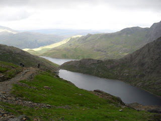
Miners Track
This is the easiest of the paths. It is very well maintained. Route finding is very easy, even in fog. Suitable for children
- This walk starts at the Pen-y-Pass car park.
- Take the car wide path on the left (lower of the 2 car park levels) that slowely heads up to, then around some lakes.
- On the far side of the lakes, the path climbs steeply (some steps) to meet the Pyg Path (note the post at the top for the way down)
- Carry on climbing steeply until the rim, to meet the Lanbaris Path (note the post at the top for the way down).
- Carry on along the Lanbaris Path, alongside but just above the railway tracks, to the summit.
To descend this way from the summit, follow the railway line, after 600m, at the first post/monolith, descend steeply downhill. Turn steeply downhill at a second post/monolith towards the lakes
Pyg Track
This is a shorter but steeper than the Miner's Path.
- This walk starts at the Pen-y-Pass car park.
- Take the path on the right (upper of the 2 car park levels) that climbs slowely but surely to the top.
- Ignore the Crib Cosh path (up to the right) and later, the Miners track joining from below on the left by a post.
- Carry on climbing steeply until the rim, to meet the Lanbaris Path (note the post, for the way down).
- Carry on along the Lanbaris Path, alongside but just above the railway tracks, to the summit.
To descend this way from the summit, follow the railway line, after 600m, at the first post, descend steeply downhill. Carry straight on at the second post.
Crib Gosh Path / Snowdon Horseshoe
The Snowdon Horseshoe is regarded as one of the finest walks in the country. Be warned, that this involves scrambling, i.e. not climbing but you will need to use your hands. Crib Gosh is a knife wide arête, and there are steep drops on both sides. Even experienced walkers have died here, or become cragfast (i.e. so frightened they cannot move). People are rescued here every year - do not attempt if you are afraid of heights, in snow or ice, in rain, in high winds, or with children, or are tierd at the end of a 3 peaks challenge. Do not go down this route - the arête is 'one way'. Do not under estimate this route, especially in not perfect weather. Having said that, its so popular you will have to queue at the start of the rudge at busy times. Do not stress or hurry the person in front of you - after all, there's no hurry, you have a fantastic view to enjoy.
- This walk starts at the Pen-y-Pass car park.
- Take the Pyg path on the right (upper of the 2 car park levels).
- Take the right hand path up to Crib Gosh
- Cross the arret to the minor summit of Garnedd Ugain (1065m)
- Continue on to meet the Llanbaris path, follow it and the railway to the summit.
- The second part of the Horseshoe is taking the Watkins path down.
Y Liwedd /Watkins Path
This is the 'down' leg of the Snowdon Horseshoe, but you can go up this way - it has a non-scary ridge to traverse.
Up : Follow the Miners track, pass the first lake, but turn left just before the causeway over the large lake
Down : Head SW from the summit trig point, then descend steeply SE. At the junction go straight on around the rim (not steeply down)
Lanbaris Path (North of Snowdon)
The most popular single path, though more people start at Pen-y-pass with its 3 paths. Longer but less steep than the above, it basically follows the railway line the whole way..
- This walk starts in Llanbaris.
- Walk along Victoria Terrace, opposite the Royal Victoria Hotel, near the train station.
- The road becomes a path
- Pass Halfway House Cafe / Station
- Pass Clogwyn Station
- Continue to the summit
The national park authority advise people not to follow the railway track down - it can be slippery in snow/ice and there have been accidents
Down: Follow the path just above the railway line. The first post/monolith marks the start of the Pyg/Miners tracks. At the next junction, go left (right is the dangerous Crib Gosh route - If the path starts to climb again to a summit - go back - it is the wrong way
Snowdon Ranger Path (West of Snowdon)
This path starts on the A4085 by the Snowdon Ranger Youth Hostel and Welsh Highland Railway station.