The Broomway and Foulness Island walk
Fabled tidal road off the coast off Essex across Maplin Sands to Foulness Island.
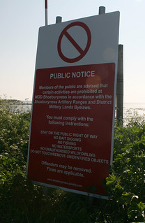
The Broomway warning notice
The Broomway is a tidal byway out to Foulness Island over Maplin Sands at the mouth of the Thames estuary. The route is so called because it used to be marked by branches of Broom placed at regular intervals on the route. However these have long since gone and the path is now unmarked. The path is dangerous because the tide comes in as fast as you can run and there are quick sands and mud in places if you stray off the route. Foulness Island itself is part of a firing range and most of it is "out of bounds" to the public with the exception of the south east corner of the island, which has a couple of villages and farms. The only road to the island can only be used by MOD permit holders, so the only way for the public to reach the island is by boat or by walking the Broomway.
foulness essex coast island swcwalks freewalks walk166 coastwalk170 14240103575
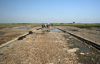
The Broomway at Wakering Stairs
The start of the Broomway as it heads out onto Maplin Sands.
foulness essex coast island swcwalks freewalks walk166 coastwalk170 14053460188
The Broomway at Wakering Stairs
Heading out onto the Broomway at Wakering Stairs over the mud flats of Mapin Sands.
foulness essex coast island swcwalks freewalks walk166 coastwalk170 14053469359

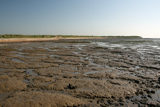
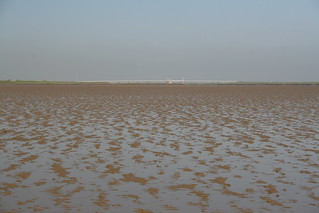
The Broomway on Maplin Sands
View out over the vast expanse of mud and sand of the Thames estuary at low tide from the Broomway. The object on the horizon is a wrecked boat.
foulness essex coast island swcwalks freewalks walk166 coastwalk170 14053531117
The Broomway on Maplin Sands
foulness essex coast island swcwalks freewalks walk166 coastwalk170 14053518230
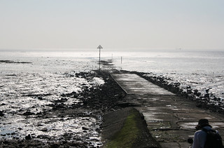
Asplins Head
The jetty onto Foulness Island at Asplins Head.
foulness essex coast island swcwalks freewalks walk166 coastwalk170 14053499009
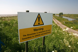
Broomway warning sign on Foulness Island
foulness essex coast island swcwalks freewalks walk166 coastwalk170 14236841471
| Dangerous Tides |
Danger of death by drowning or exposure - do not do this walk without understanding the very real dangers! There is no official 'safe' time of the tide when it is safe to walk The Broomway. The local Public Right of Way Officer's (PROW) advice is that it should ONLY be walked with a local guide. | ||||||
|---|---|---|---|---|---|---|---|
| Length | 10 miles (16 km) out and back. | ||||||
| Maps | OS Explorer Map: 176 (Blackwater Estuary, Maldon, Burnham-on-Crouch & Southend-on-Sea) | ||||||
| Toughness | 3 (flat - depends on mud and depth of water) | ||||||
| Features |
"The Broomway" is the historic route to Foulness Island, dating back to Roman times. It is a public right of way which starts at "Wakering Stairs" on the coast of Essex near Shoeburyness, and heads 300 metres out to sea onto the tidal flats of Maplin Sands. It then runs for several miles parallel to the coasts of Havengore, New England and Foulness Islands. There are several spurs back to farms (and public footpaths) on the islands. There is quicksand, and the sea comes in faster than you can run. Its easy to get disorientated if a sea fog comes in, and a strong wind can significantly reduce the 'low tide' inter-tidal window. The Broomway was the original route to the island before the advent of a road bridge in the 1930's. Historically, the route was marked by brooms stuck in the sand, but they have long since gone. Foulness Island is owned by the Ministry of Defence, and operated for them by a private company (QinetiQ) as a missile firing range. There is a road bridge to the Island, but it is closed to the public. There is a village on the island (Churchend), but the road to it has a Police checkpoint and is only open to residents. The only way to get to the Island (and its extensive network of public footpaths) is via the tidal Broomway. However, you have to go out and back via The Broomway during the intertidal 'low tide' window when it is safe to do so. There is public access to Foulness Island from 12pm-4pm on the first Sunday of the month from April to October (providing you say you wish to visit the Heritage Centre). In theory, if the tide times were right, you could be dropped off at the centre, and walk back via public footpaths to the coast, then The Broomway. Note that the Island's pub is long since closed. One problem with any potential walk is that out and back along The Broomway is too long. Ideally, it would be a linear walk to Foulness Island finishing in the village of Churchend, then a bus back to your car. While there is a bus to the Island, you must be a resident to use it - they check at the entrance to the firing range. Also, the bus does not run on Sunday, when the Heritage centre is open. QinetiQ/MOD are quite clear - you must go out and back via The Broomway. Note also that you cannot walk along the coast from Shoeburyness Station to Wakering Stairs - there is another MOD Range (Pig Bay) with no public access. The best public transport access is bus #14 to Great Wakering. The #14 route is: Southend-on-Sea - Great Wakering - Shoeburyness or (rarely) Foulness (Churchend). [Mar-24] Essex Council's Public Right of Way Office have again declined to give advice on 'safe' tide times to use the Broomway Path. They advise that it should only be used with a guide. Due to the above restrictions I have not done this walk. Until the local PROW Officer provide definitive advice on tide times, we do not recommend you do either. Other than a short walk out on to the sands from Wakering Stairs (on a falling tide!), this walk is only possible if you have local knowledge, or with the 'Nature Break' tours referenced below. Note that Wakering Stairs (and the road to it) is also inside a MOD range, and access to it is sometimes restricted for firing. Contact the range officer ( 01702 383211, 0730-1630 Mon-Thu, 0730-1230 Fri) before hand MOD/Qinetiq's advice
Other than by walking
|
| Tides |
27-Jul :
high: 05:20
low: 11:21
high: 17:37
28-Jul :
low: 00:04
high: 06:11
low: 12:09
high: 18:26
29-Jul :
low: 00:56
high: 07:07
low: 13:09
high: 19:24
30-Jul :
low: 01:59
high: 08:13
low: 14:22
high: 20:37
31-Jul :
low: 03:12
high: 09:28
low: 15:42
high: 21:54
01-Aug :
low: 04:32
high: 10:43
low: 17:09
high: 23:05
02-Aug :
low: 05:47
high: 11:44
low: 18:24
Times for . Corrected for BST if appropriate. Contains ADMIRALTY® tidal data: © Crown Copyright and database right.
|
|---|---|
| Profile | |
| Help Us! |
After the walk, please leave a comment, it really helps. Thanks! You can also upload photos to the SWC Group on Flickr (upload your photos) and videos to Youtube. This walk's tags are: |
| By Car |
Start Stairs Road, Great Wakering, Essex, SS3 9XE Map Directions |
| Amazon | |
| Help |
National Rail: 03457 48 49 50 • Traveline (bus times): 0871 200 22 33 (12p/min) • TFL (London) : 0343 222 1234 |
| Version |
Apr-24 Andrew |
| Copyright | © Saturday Walkers Club. All Rights Reserved. No commercial use. No copying. No derivatives. Free with attribution for one time non-commercial use only. www.walkingclub.org.uk/site/license.shtml |

