Wadhurst to Tunbridge Wells walk
Plenty of fine views on this short High Weald walk to the spa town of Royal Tunbridge Wells.

CIMG9606
Permissive path through Eridge Old Park
Nov-13 • Sean O'Neill
banner, swcwalk196, swcwalks 5963245083260721986 P

CIMG9045
The Nevill Crest at the golf club
Oct-13 • Sean O'Neill
swcwalk19, swcwalk196, swcwalks, walkicon 5963245667981105490 P

CIMG9045
The Nevill Crest at the golf club
Oct-13 • Sean O'Neill
swcwalk19, swcwalk196, swcwalks, walkicon 5953964414343486082 P

CIMG9502
Sussex Border Path near Buckhurst Place
Nov-13 • Sean O'Neill
swcwalk196, swcwalks, walkicon 5963244312239221426 P

CIMG9577
View across Eridge Old Park
Nov-13 • Sean O'Neill
swcwalk196, swcwalks, walkicon 5963244690843802114 P


DSCF7451
St Alban's Church, Frant
Apr-11 • Sean O'Neill
swcwalk19, swcwalk196, swcwalks 5599908296529166226 P
| Length |
Main Walk: 13¼ km (8.2 miles). Three hours 20 minutes walking time. For the whole excursion including trains, sights and meals, allow at least 8 hours. Main Walk, with longer ending: 16 km (9.9 miles). Four hours walking time. Short Walk, finishing at Frant station: 11 km (6.8 miles). Two hours 45 minutes walking time. |
|---|---|
| OS Map |
Explorer 136. Wadhurst, map reference TQ621330, is in East Sussex, 7 km SE of Tunbridge Wells, which is in Kent. |
| Toughness |
4 out of 10 (5 with the longer ending, 3 for the Short Walk). |
| Features |
This short walk near the border of East Sussex and Kent takes in similar territory to the Wealden walks from Book 2, with the first 1 km being the same as the Wadhurst Circular walk (2–18). It starts along the Sussex Border Path, a long-distance east-west route which here includes open ridges with fine views, interspersed with short sections across streams in wooded valleys. The latter provided the water power for the Wealden iron industry, Britain's ‘first industrial revolution’; in the 16th & 17thC this would have been a busy industrial area but today only traces remain in names like Furnace Wood. Across the A267 the scene changes to the landscaped parkland of the Nevill Estate's Eridge Old Park, where the colours on the mature beech trees are particularly attractive in late autumn. A permissive path along its eastern boundary (see Warning below) takes you to a lunch stop in the elegant hill-top village of Frant, dominated by its large triangular green. The afternoon section heads northwards across a valley and soon reaches the outskirts of Tunbridge Wells. Unless you choose a new longer ending there is then a relatively traffic-free route along back streets and alleyways to its High Street. No directions are given here for a longer exploration of this attractive spa town, but the Leigh to Tunbridge Wells walk (1–15) and the Tunbridge Wells Circular walk (#19) both enter the town via the large Common and go through the Pantiles and High Street to the station. |
| Warning |
The original walk route in §C made use of one of the permissive paths through Eridge Old Park established under the Environmental Stewardship Scheme. All financial support for this scheme ended in 2020 and there is no longer any incentive for the Nevill Estate to maintain these paths for public use. The Permissive Access notices and a few “DEFRA Conservation Walks” waymarkers were still in place when last checked, but the path has become unpleasantly boggy in places. An alternative (but all-road) route has been added to §C, but you would have to switch to this well before the start of the permissive path. |
| Walk Options |
As mentioned above you could take a longer ending into Tunbridge Wells, which takes in the “spacious and elegant” Dunorlan Park, originally the private grounds of a Victorian mansion. A drawback of this option is that much of the final section is along main roads – rather too many of the town's quieter streets have “No Public Right of Way” signs to shield their desirable properties from the public gaze. However, there is a short stretch near the end through another public park, Calverley Grounds. For a very short afternoon you could head for Frant's station, which is in the neighbouring village of Bells Yew Green. However, this Short Walk should be used with caution: although it includes some fine views and a pleasant descent through a wood, the final ten minutes are along a busy road with no pavement. |
| Transport |
There is a half-hourly off-peak service from Charing Cross to Tunbridge Wells and Wadhurst, taking just over an hour to Wadhurst. If you finish at Frant station (the one between these two), it only has an hourly service. Buy a return to Wadhurst. If you want to finish the walk after lunch in Frant, an alternative to walking to its remote station is to take one of the regular buses from the stop opposite the Abergavenny Arms to Tunbridge Wells; in the other direction the 1066 (to Hastings!) would also take you back to Wadhurst station. If driving, Wadhurst station car park costs around £6 Mon–Fri, £5 Sat, £3.50 Sun & BH (2024). You could instead try parking at the end of the walk in Tunbridge Wells, but parking anywhere near the centre of the town is difficult and/or relatively expensive. |
| Suggested Train |
Take the train nearest to 09:45 from Charing Cross to Wadhurst. |
| Train Times |
|
| Timetables |
|
| Lunch |
The village of Frant (after 8¼ km) has two good pubs as well as a convenience store, open daily. The suggested lunch pub is the popular George Inn (01892-750350; closed Mon lunchtime) on a quiet street by the church; it has a beer garden and serves good food, up to 2.30pm. The equally good alternative is the Abergavenny Arms (01892-750233; closed Mon) on the main road; it has a patio area at the front and also serves good food to 2.30pm, later on Sundays. |
| Tea |
On the main ending you pass several cafés, delicatessens and coffee shops on the High Street, such as Juliets at #54 (01892-522931; open Tue–Fri & Sun to 4pm; Sat to 5pm). On the longer ending the most convenient places are two park cafés, both of which are usually open daily to 5pm: the Dunorlan Park Café is about 2 km before the finish, while the Tea House in Calverley Grounds is just 250m from the station. There are also plenty of pubs in the town, with the most unusual being the Opera House, a splendid building which more recently was a cinema and bingo hall and is now a JD Wetherspoon pub; it is a five-minute walk up Mount Pleasant Road from the station. If you have to wait for a train on the alternative ending, the convenience store near Frant station serves hot drinks. Just up the road in the centre of Bells Yew Green, the Brecknock Arms (01892-750237) is normally open all day. |
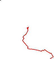
| Profile | |
|---|---|
| Help Us! |
After the walk, please leave a comment, it really helps. Thanks! You can also upload photos to the SWC Group on Flickr (upload your photos) and videos to Youtube. This walk's tags are: |
| By Train |
Out (not a train station) Back (not a train station) |
| By Car |
Start TN5 6RZ Map Directions Return to the start: Finish TN1 1BT Map Directions Travel to the start: |
| Amazon | |
| Help |
National Rail: 03457 48 49 50 • Traveline (bus times): 0871 200 22 33 (12p/min) • TFL (London) : 0343 222 1234 |
| Version |
Apr-24 Sean |
| Copyright | © Saturday Walkers Club. All Rights Reserved. No commercial use. No copying. No derivatives. Free with attribution for one time non-commercial use only. www.walkingclub.org.uk/site/license.shtml |


Walk Directions
Click the heading below to show/hide the walk route for the selected option(s).
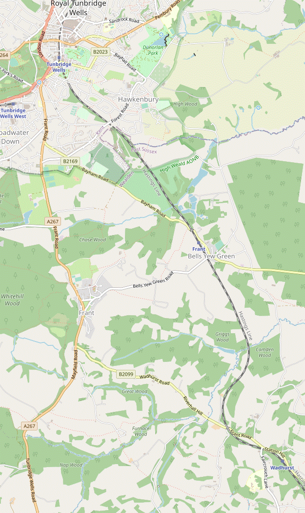


 Walk Map
©
Walk Options
Click on any option to show only the sections making up that route, or the heading above to show all sections.
- Main Walk (13¼ km)
Walk Directions
Click on any section heading to switch between detailed directions and an outline, or the heading above to switch all sections.
- Wadhurst Station to Buckhurst Lane (2¼ km)
- Outside the station turn right through its car park and go uphill on the B2099. In 150m turn right onto the Sussex Border Path (SBP). Follow it across the railway and then along a farm drive to Tapsells Lane. Turn right onto the lane and go straight across Faircrouch Lane onto the driveway to Ravensdale Farm. Turn right in front of the farm buildings and follow the footpath along field edges, across a woodland stream and up another field. At the top turn left onto Buckhurst Lane.
- Outside the station turn right, go through its car park and continue uphill on the B2099 for 150m. Opposite a small development called “The Keys” veer right off the road onto an easily-missed public footpath, joining the Sussex Border Path? (SBP). Go down a slope towards the railway and cross the tracks carefully.
- On the other side follow the footpath waymarkers to head S across a field, then through a small wood. Go through a wooden gate onto a narrow enclosed path past farm buildings and out along its drive. At the end turn right onto a lane, soon ignoring a footpath off to the left (the Walk 2–18 route) to reach a T-junction with a minor road.
-
Go straight across this road onto a driveway to the right of a garage. Follow this public footpath past a few houses and downhill through a wood, curving left around a pond at the bottom. As the drive approaches the buildings of Ravensdale Farm turn right as indicated through a wooden gate and follow a grassy path down the left-hand side of a field, heading NW.
- There might be a minor footpath diversion here, but the new route should be easy enough to follow.
- Near the bottom follow the path round to the left and into the trees. Cross a stream on a wooden footbridge and go up a potentially muddy sunken path, through a gate and along the right-hand edge of two fields. After curving round to the left in the second field, follow the path down into the trees on your right.
- At the bottom cross a stream on a wooden footbridge and follow the path up and round to the left. Go through a metal gate into a large field and make your way up to its top left-hand corner, where you will be able to see an imposing building on the hill behind you, The Mount?. At the top go through a metal side gate and turn left onto a minor road (Buckhurst Lane).
- Buckhurst Lane to Lightlands (2¼ km)
- Go along Buckhurst Lane for 100m and turn right onto a footpath, staying on the SBP. Head west along field edges, then across a wooded valley to Partridges Lane. Turn right onto the lane, cross another stream and turn left onto a footpath, still on the SBP. Go up a field edge and follow the waymarkers between the buildings of Earlye Farm. Head north-west down across a field to a strip of woodland. Cross a stream and climb steeply up the next field to reach a footpath crossing at Lightlands.
- Go along the lane for 100m and then turn right onto a car-wide track, with a footpath signpost half-hidden in the hedge. Go through a couple of side gates and then turn half-left as indicated to stay alongside a wire fence. At the end go through another wooden side gate in a belt of trees and bear right to go alongside them.
- Continue along the right-hand edge of two large sloping fields for 600m, still on the SBP and with fine views off to your left. At the end of the second field go through a wooden side gate on the right and turn left as indicated.
- Go along the left-hand edge of this field and through a kissing gate in the bottom corner. Follow a slightly awkward path going steeply downhill through a wood, crossing a stream at the bottom. The path comes out onto a minor road (Partridges Lane).
- Turn right and go along the lane for 175m, curving round to the left and then going across a semi-cleared valley. As the lane swings back to the right turn left onto a signposted footpath going steeply up the wooded valley. At the end of the trees go through a wooden gate and continue up the right-hand edge of a large field.
- In the corner go through a metal fieldgate onto a farm track, passing a converted oast house on your left. At a T-junction turn left onto a track towards the buildings of Earlye Farm. After passing the farmhouse follow the yellow waymarkers (slightly to the left) between barns and sheds to a wooden gate leading into a field.
- Go straight across the field, roughly parallel to the hedge on your left; as the ground dips away towards a wooded valley aim for a wooden gate near the bottom left-hand corner. Go through this and down an awkward slope (with a helpful handrail), then across a stream on a wooden footbridge. Go up to a wooden gate leading into another field and climb steeply up its right-hand edge.
- In the top corner go through a gap and bear right across the next field to a gate in the far right-hand corner, which takes you onto a narrow path between hedges. This comes out onto the driveway to “Lightlands” by a four-way footpath signpost.
- Lightlands to Frant (Shernfold Park) (3¼ • 2 km)
-
For the main route turn left and head west along field edges to Pococksgate Farm. Go out along its driveway to the A267 and turn right briefly onto the main road, leaving the SBP. Take a track heading towards Eridge Old Park, but almost immediately turn right onto the start of a permissive path. Follow this (problematic) path through a belt of woodland between Eridge Old Park and the A267 for over 1½ km. At the end join both the High Weald Landscape Trail (HWLT) and the Tunbridge Wells Circular Walk (TWCW), coming in from a public footpath across the parkland. Return to the A267 and turn left into Frant.
- For a shorter route avoiding the permissive path, keep ahead on Down Lane (leaving the SBP). At the far end turn right onto the A267 and follow it into Frant.
-
Original route, via Eridge Old Park (3¼ km)
- Turn left through a gate and follow a faint grassy path straight ahead across a meadow, staying on the SBP. On the far side go through a metal fieldgate and continue along the right-hand edge of the next field. In the corner a small metal gate takes you into another field.
- Veer right to follow a faint path uphill, initially alongside the tree boundary and then heading across the grass towards a wide gap into the next field. A waymarker on a post here points towards its far right-hand corner, although if there is no clear path you might find it easier to walk around the broad grassy margin.
-
Either way, go through the fieldgate on the far side (not the one in the hedge on your right). Continue in much the same direction along the top edge of several more fields towards some large barns 400m away, going through more fieldgates as necessary.
- Across the valley on your left you might be able to see the top of Saxonbury Hill Tower? poking out above the trees of Nap Wood.
- In the last field aim for the left-hand side of these barns. Go through a double metal fieldgate and bear left across the farmyard. In the corner go through a gate onto a track going downhill. At the bottom turn right in front of the buildings of Pococksgate Farm and follow its driveway out to the A267.
- Turn right briefly onto the main road, crossing over with great care at some point. Ignore a footpath signpost pointing to a narrow path through the bracken (the continuation of the SBP) but shortly afterwards turn left briefly onto a car-wide track, a private entrance into Eridge Old Park?.
- The continuation of the walk (as originally devised) is an inconspicuous path into the undergrowth on the right of the track, just a few metres from the road. There should be an information panel confirming that this was established as a permissive route through the Nevill Estate.
-
Follow the path through the trees and bracken, gradually moving away from the noisy main road. In 400m go straight across a driveway to continue through the woodland.
- This path soon becomes quite faint and it appears that some walkers take the broad grassy path along the edge of the narrow field to the left of the wood. If you do this, follow the path back into the trees after 200m.
- Where these two routes rejoin a waymarker on a tree trunk confirms that you continue in much the same direction. After scrambling across a small stream follow the path uphill and veer left at a path junction.
- You are now essentially following the course of a high deer fence, just off to the left on the edge of the parkland. If the path forks take either route: the paths seem to change slightly over time as attempts are made to skirt around some awkward stretches, but they always rejoin.
- In around 400m you pass Saxonbury House? off to the right. In the remaining 400m you might have to negotiate (with increasing difficulty) some unpleasantly boggy patches where the path dips down across seasonal streams.
-
Eventually you reach a pedestrian gate in the deer fence with waymarkers on a nearby footpath signpost for both the High Weald Landscape Trail? (HWLT) and the Tunbridge Wells Circular Walk? (TWCW). Do not go through this gate but in 20m turn right at another footpath signpost.
The route to Tunbridge Wells follows these two waymarked trails for the next 3 km, as well as (in reverse) the Walk #19 route.
- Follow the fenced path uphill. It curves left and right, narrows and comes out between buildings onto the A267. Cross this main road carefully and turn left onto the pavement. In 75m you cross over the driveway to Shernfold Park and enter the village of Frant.
-
Alternative route, via Down Lane (2 km)
- At the path crossing go straight ahead onto a narrow lane (Down Lane), leaving the SBP. You now simply follow this long and winding lane all the way to its T-junction with the A267 (Mayfield Road).
- Turn right onto the pavement beside the main road, the start of 700m of unappealing roadside walking. In 250m keep ahead at the junction with the B2099 (Wadhurst Road). Eventually …
- Shernfold Park to Frant Church (½ • ¾ km)
-
Go alongside the A267 to the triangular village green. For the main route, go up its right-hand side and continue along the High Street to find the George Inn by the junction with Church Lane.
- Alternatively, go across the bottom of the green to find the Abergavenny Arms on the A267. In a further 100m turn right into Church Lane and go up to its junction with the High Street.
- Bear right onto a patch of grassland beside the road, soon crossing another driveway and then a side road (The Green) to come to the main part of the sloping village green.
-
Main route (½ km)
- Bear right to go gently uphill between the cricket pitch and The Green, heading towards a small building with a pyramidal tiled roof (an old well). In the top corner of the main green cross a side road (The Green again) and go past the well.
- Continue along Frant's picturesque High Street, heading towards the church. At the end you come to the George Inn on the right, opposite the Old School?.
-
Alternative route (¾ km)
-
The Abergavenny Arms is on the right-hand side of the main road just beyond the green. If you walk across the green you can go past the right-hand side of a house on the corner and down a few steps onto a side road (The Green again) in order to return to the main road.
- There is also a convenience store in the Post Office at the bottom of The Green.
- To resume the walk turn right out of the pub to go along the A267 for a further 100m. Turn right into Church Lane and follow this narrow lane uphill for 200m to its junction with the High Street.
- Frant Church to Forest Road (3 km)
- Go through the churchyard and follow the HWLT and TWCW north along field edges, down through Chase Wood and past Brickhouse Farm to Bayham Road. Continue along the edge of Nevill Golf Course and turn left onto Benhall Mill Road, leaving both the HWLT & TWCW. In 400m take a footpath on the right through woodland. At the far end turn right onto Forest Road.
- Go through the lychgate and up to the church of St Alban?, which is worth visiting. Follow the path round to the right of the church and all the way to the far corner of the churchyard. Make your way into the top of a large field and continue in the same direction, with a hedge on your right. In 100m there is a three-way footpath signpost by a gap in the hedge.
- Carry on down the field edge and go through a gap in the trees in the bottom corner. Bear right to go down another field edge to the bottom corner, crossing over a track along the way. Go through a wicket gate and follow a path on a long steady descent through Chase Wood.
- Towards the bottom stay on the main path as it curves round to the left. Immediately after crossing a small stream fork right as indicated, then keep right at the next path junction. After crossing a footbridge over another stream at the edge of the wood, ignore a stile leading into a field on the right and continue on a tree-lined path between fields, heading N.
- In 200m the path comes out in front of Brickhouse Farm. Turn left briefly onto a farm track, then in 25m turn right into its farmyard. Go along its left-hand side and continue on the farm's long drive to reach a road (the B2169). Cross over carefully and go through a wicket gate opposite (slightly to the left) onto a corner of Nevill Golf Course.
- Follow the right of way alongside the brick wall on your left. At the top of a practice area continue through a small car park, then keep left of the club house. After a final section alongside the main car park you come out onto a lane (Benhall Mill Road) by the Golf Club entrance, with the Nevill Crest? on top of each of the brick pillars. Turn left onto the road, leaving both the HWLT & TWCW.
- Go along the road for 400m, with a new housing estate on the right. Where the road briefly widens at the end of these houses turn right onto an inconspicuous path into some trees, signposted as a public footpath. Follow it round to the left and past the last of the new houses, then through a wood for 300m. At the end turn right onto Forest Road.
- Forest Road to Tunbridge Wells Station (2 km)
-
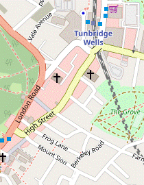 Go along Forest Road for 100m, then go down through Farmcombe Road Open Space. Turn left onto Delves Avenue and follow it to Cavendish Drive. Turn left and go along Upper Cumberland Walk to Rodmell Road. Turn right briefly onto this road, then turn left into Cumberland Walk. Shortly before this comes out onto the A267, cut through Cumberland Gardens and Mount Sion to the High Street. Go up this street and across Vale Road to the station.
- Go along Forest Road for 100m, crossing over at some point. By the Forest Way bus stop go down steps on the left and through a gate into Farmcombe Road Open Space. Go down the slope, with a line of trees on your right, to leave the recreation ground via another gate at the bottom. Go out to a residential street (Delves Avenue) and turn left.
- Follow the street round to the right. In 250m keep left where it merges with Cavendish Drive and then turn left onto a signposted footpath (Upper Cumberland Walk). This goes over the railway line and continues as a tree-lined path, then a lane. Where the lane turns half-left (and becomes Blatchington Road) keep ahead, still on Upper Cumberland Walk.
- The track goes over an old railway bridge?, bends right and comes out onto a residential street (Rodmell Road). Turn right briefly onto this street, then turn left at a footpath signpost into an alleyway (Cumberland Walk).
-
In 200m you pass a parking area and garages down to the left. In a further 100m, by an old lamppost, turn right up a few steps into Cumberland Gardens. Follow this passageway out to a street (Mount Sion) and turn left.
- In 50m you reach the town's High Street and turn right onto it. There are plenty of cafés, coffee shops and delis along this street: Juliets is on the left about halfway along, at #54.
-
At the far end of the High Street the main station entrance and ticket office is down to the left on the other side of Vale Road, along Station Approach. Most trains to London depart from Platform 1, on that side.
-
If you do not want to dodge the traffic on Vale Road you can reach the alternative station entrance in Mount Pleasant Road (straight ahead) via two sets of pedestrian traffic lights. There is an overhead walkway linking the two platforms.
-
If you do not want to dodge the traffic on Vale Road you can reach the alternative station entrance in Mount Pleasant Road (straight ahead) via two sets of pedestrian traffic lights. There is an overhead walkway linking the two platforms.
- Forest Road to Dunorlan Park Café (2¾ km)
-
 Go along Forest Road for 100m, then take a parallel route on the left through Farmcombe Road Open Space. At the far end return to Forest Road, then go along Westbrook Terrace to Hawkenbury Road. Go diagonally through Hawkenbury Recreation Ground and continue along Dorset Road. Turn right into Forest Road and follow it round to the left at a junction, then turn right into Dunorlan Park. The suggested route is to go around the right-hand side of the lake, up the avenue on the far side and back along the terrace to the Park Café.
- … Veer right through a belt of trees and make your way across the grass to leave via another gate in the middle of the far side, 150m away. Go out to a residential street (Farmcombe Road) and turn right to return to Forest Road.
- Turn left onto the main road, cross over at the traffic island and then turn right into an alleyway (Westbrook Terrace), signposted as a footpath. This goes past a row of terraced houses and veers left to emerge into a small parking area off Hawkenbury Road. Bear right to go along this road, crossing over a side street (Maryland Road), then cross the main road and go through a gate into Hawkenbury Recreation Ground.
- Take the tree-lined tarmac path straight ahead. After passing some astro-turf pitches you can either follow the path all the way round to the far right-hand corner, or take a short cut across the grass. Leave the recreation ground and bear left onto a residential street (Sherborne Close, which becomes Dorset Road). Follow this out to Forest Road (again).
-
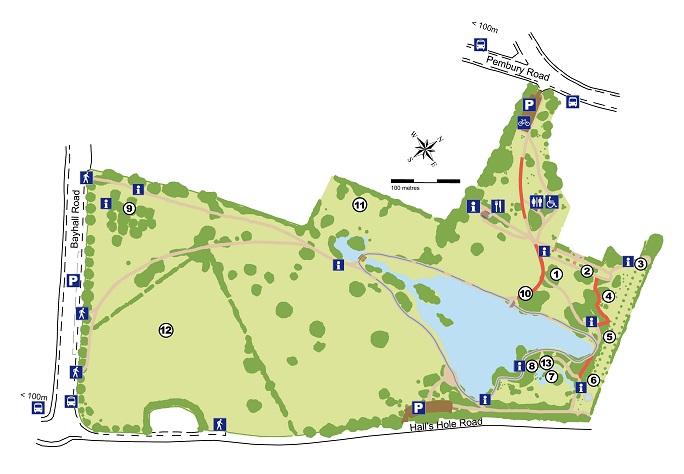
Turn right onto the main road and go along its right-hand pavement. Follow it round a sharp left-hand bend at a junction, crossing Hall's Hole Road. After passing the Rookley Close bus stop turn right through a black metal gate in the hedge, a pedestrian entrance into Dunorlan Park?.
The route described below reaches its café via a loop around the lake, but you could use the map to devise a more direct route.
-
For the suggested route bear slightly right across the grass, skirting a protruding clump of trees on the right and passing another pedestrian entrance (from Hall's Hole Road) off to the right. Near the far right-hand corner go through a gap in the trees and carry on near the edge of the park.
- When the lake comes into view, take any route down the slope and bear right to go alongside it. Follow the winding perimeter path until you come to some black metal railings on the right over the Cascade.
- Go down a flight of steps beside the waterfall and continue past the Summerhouse in the small Water Garden. Go over some stepping stones and keep ahead through a gap in the trees to come to the bottom of the Avenue, with the (restored) Statue of Hebe on the Fountain.
-
Go all the way up this broad grassy strip between cedars to the Grecian Temple. At the top take the level path on the left, which leads into the Terrace. At the far end keep ahead to come to the Park Café, the suggested tea stop.
- Dunorlan Park Café to Tunbridge Wells Station (2 km)
-
 Leave the park by the main exit and turn left onto the A264, crossing over onto the adjacent cycleway. In 500m fork right into Calverley Park Gardens and follow this downhill to a major road junction. Continue along Crescent Road for 150m, then turn sharp left through an archway into Calverley Park. Take the path on the right into Calverley Grounds, where there is a café. Leave the gardens by the main exit and go across Mount Pleasant Road to the station.
- From the café go up the grassy slope, away from the lake. At the top take the path to the right of the car park to leave Dunorlan Park by a side gate. Turn left onto the A264 (Pembury Road) and cross it at the nearby pedestrian lights to continue on the combined pedestrian and cycleway.
- You have to put up with the traffic on this busy road for 500m before you can fork right into Calverley Park Gardens. Follow this much quieter road as it curves down to the left, soon with glimpses of the large Spa Hotel ahead on the horizon, 1¾ km away. The road ends at a T-junction with Calverley Road.
- The nicest (and shortest) continuation would be one of the private roads opposite, but in deference to the “No Public Right of Way” notices you should take the main road ahead on the right (Crescent Road), alongside the back of Calverley Crescent.
-
After passing the other end of the private road for this building turn sharp left through an imposing carriage archway with a sign for Calverley Park?. Before reaching the stone pillars at the entrance to the park turn right onto a tarmac path, passing an information panel for Calverley Grounds?.
The panel confirms that public access into Calverley Grounds is permitted through the archway, despite the “Private” notices.
-
Follow the path downhill between hedges and then past a basketball court. Keep ahead at a path junction, then go down steps on the right and turn right at the bottom to come to a possible refreshment stop, the Tea House? café.
- For a small detour you could carry on past the steps and double back through the small Sunken Garden on the right.
- To complete the walk, turn right out of the café and follow the path as it curves down to the main entrance. Keep ahead along a short street to reach Mount Pleasant Road and cross this main road carefully.
-
The suggested route is to turn left to come to the Mount Pleasant Road station entrance, 50m away. Most trains to London depart from Platform 1, which you reach via the overhead walkway.
-
After crossing Mount Pleasant Road you could also take a path just off to the right, behind Bus Stop B. This takes you over the railway and down to the ticket office, which leads onto Platform 1.
-
After crossing Mount Pleasant Road you could also take a path just off to the right, behind Bus Stop B. This takes you over the railway and down to the ticket office, which leads onto Platform 1.
- Frant Church to Frant Station (2¾ km)
- Go through the churchyard and follow the HWLT and TWCW north for 100m, then turn right onto a footpath going via Ely Grange to the B2169. Turn right and go along the road to Frant station.
- …
- To head for Frant station turn right through this gap, leaving both the HWLT & TWCW. Follow a faint grassy path across a sloping field for 500m, roughly parallel to a track below and with fine views off to the left.
- At the end of the field go through a wicket gate and bear left across a driveway as indicated. Go along a short grassy strip and over a stile onto a track between tall hedges. Follow this round to the left, passing a paddock and stables on the right. Go over a stile to the left of a wooden gate and follow the track round to the right, heading NE on the edge of a wood.
- The right of way stays close to the fence on the right, but if this main track is too muddy there is an alternative path on the left which rejoins it near the entrance to a water treatment plant (a wooden fieldgate with a prominent “Keep Out” notice). Keep ahead on a woodland path going gently downhill through the trees for 500m, staying fairly close to the left-hand edge of the wood.
- The footpath eventually comes out abruptly onto the B2169. Turn right onto this busy road, taking great care as there is no pavement. You have to negotiate this awkward stretch of road for 800m, with a particularly tricky spot two-thirds of the way along where it bends left and right under a railway bridge, with limited visibility.
-
As you reach the small village of Bells Yew Green? the entrance to Frant station is on your right. Cross the footbridge to Platform 1 for trains to London.
- The only refreshment places in the vicinity are a convenience store (serving hot drinks) just past the station entrance and the Brecknock Arms in the village centre, 250m further along the road.
- The Sussex Border Path runs for 240 km along the length of West & East Sussex, from Thorney Island on the Hampshire border to Rye.
- The Mount was originally a Victorian monastery. Since 1970 it has been The Mount Camphill Community, a residential centre for students with learning difficulties.
- Saxonbury Hill Tower is a gothic folly on the Eridge Park estate, built in 1828.
- The spacious parkland of Eridge Old Park was landscaped in the late 18thC by Henry Nevill, the 2nd Earl of Abergavenny, who built Eridge Castle in Strawberry Hill Gothic style (replaced in the 1930s by a Georgian style mansion, Eridge Park).
- Saxonbury House looks historic but was built in the 1950s, in the style of a Queen Anne house.
- The High Weald Landscape Trail runs for 145 km across the length of the High Weald, mostly near its northern edge, from Horsham in West Sussex to Rye.
- The 44 km Tunbridge Wells Circular Walk (formerly the High Weald Walk) was established by the Borough Council as one of its centenary events in 1989.
- On Frant's Old School, the inscription Train up a child in the way he should go: and when he is old, he will not depart from it is from Proverbs 22:6.
- St Alban, Frant was almost completely rebuilt in 1822 when the medieval church became uneconomic to repair. It has a particuarly fine August Gern organ.
- The Nevill Crest is a bull with a crown around its neck. The family motto Ne vile Velis (‘never have evil thoughts’) incorporates their name, then spelt Nevile.
- The railway bridge in Upper Cumberland Walk crosses a disused spur which linked the main Hastings line with Tunbridge Wells West station, now the terminus of the Spa Valley Railway.
- Dunorlan Park was originally the private grounds of a Victorian mansion built for Henry Reed, who made his fortune in Tasmania. The gardens were laid out by the renowned Victorian gardener Robert Marnock in the mid-19thC. The estate was purchased for the town in 1945 and the park opened to the public, but soon afterwards the large Italianate mansion was badly damaged by fire and later demolished.
- The Calverley Park estate was laid out in the 1830s by Decimus Burton, as commemorated on a plaque on the carriage archway at the Crescent Road entrance. The estate included the large Mount Pleasant House, Calverley Park Crescent and the villas in Calverley Park, together with extensive grounds.
- Calverley Grounds were originally the pleasure grounds of Mount Pleasant House, later the Calverley Hotel. They were purchased for the town in 1920. Near the main entrance there is a memorial to Lord Dowding, the commander of RAF Fighter Command during the Battle of Britain (1940).
- The present Tea House is a replica of one which burnt down in 1997. A concert pavilion and bandstand on the site were destroyed by an air raid in 1940.
- The unusual name Bells Yew Green is derived from the medieval French Bels Lieux, the ‘beautiful place’ being the nearby Bayham Abbey.
As noted in the Introduction, the original route for this section includes a poorly-maintained permissive path. If you carried on for 1½ km to the start of this path and then found that access had been withdrawn you would have to endure a very long stretch along the busy A267, so there is an option to switch here. The alternative route in [?] is all along roads but Down Lane has hardly any traffic, and it would cut out 1 km of the A267 stretch.
The main route takes you past the George Inn on the village's High Street, but if you want to visit the Abergavenny Arms follow the directions in [?].
If you are doing the Short Walk (to Frant station), go to §I.
If you are doing the longer ending (via Dunorlan Park), go to §G.
Walk Notes
» Last updated: April 8, 2024
Return to Top | Walk Map | Walk Options | Walk Directions.