Westbury to Warminster via Imber Range walk
Westbury White Horse, 5 hills (3 of which Iron Age Camps), pristine chalk downland on Salisbury Plain, an abandoned village on the rarely open Imber Range

Westbury Hill, with White Horse
SWC Walk 286 Westbury to Warminster (via Imber Range)
Jan-17 • thomasgrabow on Flickr
banner walkicon swcwalks swcwalk286 33226099910

Imber Village, Traffic Sign
SWC Walk 286 Westbury to Warminster (via Imber Range)
Jan-17 • thomasgrabow on Flickr
walkicon swcwalks swcwalk286 33452580262
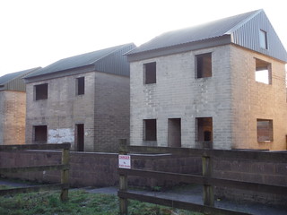
Imber Village, Shells of Houses used for combat training
SWC Walk 286 Westbury to Warminster (via Imber Range)
Jan-17 • thomasgrabow on Flickr
walkicon swcwalks swcwalk286 33225814260
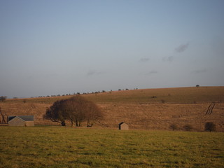
Ruined Farm Buildings on Salisbury Plain, off American Road
SWC Walk 286 Westbury to Warminster (via Imber Range)
Jan-17 • thomasgrabow on Flickr
walkicon swcwalks swcwalk286 33479864601

Young green growth on red soil, near Reeves Farm
SWC Walk 286 Westbury to Warminster (via Imber Range)
Apr-17 • thomasgrabow on Flickr
walkicon swcwalks swcwalk286 33736240130
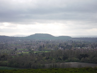
Cley Hill beyond Warminster
SWC Walk 286 Westbury to Warminster (via Imber Range)
Apr-17 • thomasgrabow on Flickr
walkicon swcwalks swcwalk286 33736198250

Battlesbury Camp
SWC Walk 286 Westbury to Warminster (via Imber Range)
Apr-17 • thomasgrabow on Flickr
swcwalks swcwalk286 walkicon 34121036225
| Danger Area |
You must check the Imber (Salisbury Plain) firing range is open before doing this walk.
|
|---|---|
| Length |
30.3 km (18.8 mi), with 553/494m ascent/descent. For a shorter walk see below Walk Options. |
| Toughness |
8 out of 10, with 7 hours walking time. For the whole outing, including trains, sights and meals, allow at least 12 hours. |
| Walk Notes |
Bookended by urban stretches through Westbury and Warminster, this walk is a fascinating journey across the Imber Live Firing Range on Salisbury Plain to the abandoned village of Imber, nestled in a secluded wooded downland valley. The Plain is full of pre-historic sites and the Range an accidental wilderness as it’s been MoD property since 1898, out-of-bounds for most of the year apart from short stand downs over Christmas and Easter and for some weeks in August (most years). Either side of the Plain the route crosses five hills, three of which with notable remnants of Iron Age hillfort sites: Bratton, Scratchbury and Battlesbury Camps, and it also passes Wiltshire’s largest White Horse, at Westbury.
Shorter walks, starting from Bratton or Edington, or finishing in Heytesbury, involve short bus journeys. Note: Before embarking on this walk, please read below chapters on Public Safety and Access Rights on Salisbury Plain/Imber Range and on General Health & Safety Rules for military areas and ranges |
| Walk Options | Alternative Start from Bratton, a 12-minute bus journey from Westbury on line 87/87A (Trowbridge – Devizes) with 5 buses on weekdays and 7 on Saturdays (01/17 price: £1.90), cuts 5.5 km/3.4 mi and 67m ascent. This cuts Westbury, the White Horse and the Bratton Camp Iron Age hillfort site. Rated 7/10.
|
| Maps |
OS Explorer: 143 (Warminster & Trowbridge)
|
| Travel |
Westbury Station is a stop on the Paddington to Taunton Great Western Main Line, the Bristol to Weymouth Heart of Wessex Line (via Bath Spa) and the occasional service from Waterloo via Salisbury, journey time from 77 mins Mon-Fri, 74 mins Sat and 70 mins Sun. Warminster is a stop on the Bristol to Portsmouth Wessex Main Line (via Bath, Westbury and Salisbury) and also served by occasional direct services to Waterloo, journey time to London from 109 mins Mon-Fri, 97 mins Sat and 123 minutes Sun. Saturday Walkers’ Club: Both stations are outside the Network Southeast. Singles or split tickets may be cheaper than a simple return, advance booking is recommended. Take the train closest to 08.00 hours. |
| Lunch |
Picnic
|
| Tea |
Heytesbury
Warminster
|
| Imber Range |
Public Safety and Access Rights on Salisbury Plain/Imber RangeThe current status of access rights on Salisbury Plain should be checked at https://www.gov.uk/guidance/public-access-to-military-areas#contents [under ‘Locations in South West England – Salisbury Plain] At time of writing the rules relevant for this walk are as follows:
The main points:
General Health & Safety Rules for military areas and ranges
|
| Profile | |
|---|---|
| Help Us! |
After the walk, please leave a comment, it really helps. Thanks! You can also upload photos to the SWC Group on Flickr (upload your photos) and videos to Youtube. This walk's tags are: |
| By Train |
Out (not a train station) Back (not a train station) |
| By Car |
Start BA13 4HP Map Directions Return to the start: Finish BA12 9BP Map Directions Travel to the start: |
| Amazon | |
| Help |
National Rail: 03457 48 49 50 • Traveline (bus times): 0871 200 22 33 (12p/min) • TFL (London) : 0343 222 1234 |
| Version |
Apr-24 Thomas G |
| Copyright | © Saturday Walkers Club. All Rights Reserved. No commercial use. No copying. No derivatives. Free with attribution for one time non-commercial use only. www.walkingclub.org.uk/site/license.shtml |

Walk Directions
Full directions for this walk are in a PDF file (link above) which you can print, or download on to a Kindle, tablet, or smartphone.
This is just the introduction. This walk's detailed directions are in a PDF available from wwww.walkingclub.org.uk