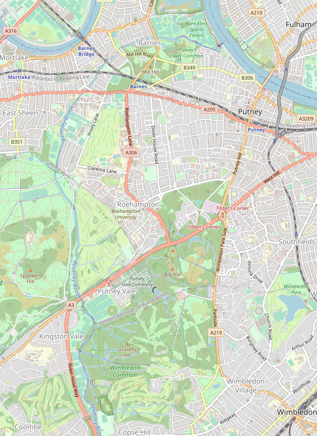
Wimbledon to Putney walk
Through Cannizaro Park, Wimbledon Common, Richmond Park and Barnes Common to the Thames.
| Length |
Main Walk: 15½ km (9.6 miles). Three hours 25 minutes walking time. For the whole excursion including trains, sights and meals, allow at least 6½ hours. Short Walk, finishing at Barnes Bridge: 11½ km (7.1 miles). Two hours 30 minutes walking time. |
|---|---|
| OS Map |
Explorer 161. Wimbledon is in south-west London, 10 km SW of Westminster. |
| Toughness |
2 out of 10 (1 for the Short Walk). |
| Features |
This walk was inspired by the Beverley Brook Walk (BBW), which follows the course of the river for 11½ km from New Malden station to the River Thames. However, the BBW starts with a fairly long suburban stretch within earshot of the noisy A3, which is less of a problem with this walk's alternative start from Wimbledon station. Although its first 1¼ km is also along residential streets, the rest of this link route is across Wimbledon Common with the bonus of an attractive section through the landscaped Cannizaro Park. The walk joins the BBW in the south-western corner of Wimbledon Common for a 2 km woodland stretch (which can be muddy) alongside the river, where the traffic noise is at least partly shielded by trees. After crossing the A3 the walk goes through Robin Hood Gate into Richmond Park, the largest of London's Royal Parks and home to over 600 Red and Fallow deer. A rather more appealing 2 km parkland stretch alongside the river leads to a possible refreshment stop at the park café near the Roehampton Gate exit. A suburban stretch through Roehampton leads into Barnes, where the walk again deviates from the BBW to offer a choice of refreshment places on its way through the village on the river. You could finish here, but the full walk rejoins the BBW to go via Barnes Common (with its abandoned old cemetery) and the adjacent Lower Putney Common to the River Thames. It concludes with a riverside stretch past a long string of boathouses on Putney Embankment, with a choice of stations on either side of Putney Bridge for the return journey. |
| Boat Race |
The 4¼ miles from Putney Bridge to Chiswick Bridge are the traditional venue for the annual Oxford and Cambridge Boat Race, held in spring. This event attracts large crowds and the pubs might be rather busier than usual that afternoon. |
| Walk Options |
Near the start of the walk some short cuts (and an optional extension) are described for the section through Cannizaro Park. After the lunch stop in Barnes there are many alternatives to the route described here. You could simply complete a Short Walk by returning from Barnes Bridge station; switch there to the Norbiton to Hammersmith or Putney walk (#261); stay on the Thames Path from Barnes to Putney; or follow it in the opposite direction towards Kew and Richmond. The Thames Path alternatives are described in the Putney to Richmond walk (#390). At Barnes Green you could divert to the London Wetland Centre, 1 km away along Church Road and Queen Elizabeth Walk (continuing along this cycle route afterwards to rejoin the Thames Path). No directions are given here but it is easy to work out the route from the map. At Putney Bridge you could extend the walk by continuing downstream on the Thames Path towards Wandsworth and Westminster, as described in the Tower Hill to Putney walk (#282). |
| Transport |
There are frequent trains from Waterloo to Wimbledon, plus a half-hourly Thameslink service via Blackfriars and Elephant & Castle. The station (in TfL Zone 3) is also the terminus of one of the branches of the District line. Putney has a mainline station (Zones 2/3) with frequent trains to Waterloo, plus a separate underground station (Putney Bridge, Zone 2) on the Wimbledon branch of the District line. At the end of the Short Walk, Barnes Bridge station (Zone 3) is on the Hounslow Loop line with half-hourly trains to Waterloo. |
| Suggested Train |
If you want a pub lunch it would be advisable to start no later than 10:30am, as the places in Barnes are nearly three-quarters of the way through the walk. With a later start you could break at the café and picnic tables in Richmond Park. |
| Train Times |
|
| River Levels |
|
| Lunch |
After leaving the Wimbledon area there are no refreshment places until you reach the Roehampton Gate café in Richmond Park, after 8¾ km. However, about 40 minutes later you will find a wide choice of pubs and other eateries in Barnes village, after 11–12 km. In the order in which you pass them the pubs are The Crossing (020-8251 1244), Ye White Hart (020-8876 5177), the Watermans Arms (020-8878 8800), the Bulls Head (020-8876 5241), the Coach & Horses (020-8876 2695) and the Sun Inn (020-8876 5256). |
| Tea |
The route along Putney Embankment passes a park café and two large riverside pubs, the Duke's Head (020-8788 2552) and the Star and Garter (020-8788 0345). The suggested refreshment places are on the riverside terrace on the other side of the A219 at Putney Bridge. If you get there in time the Putney Pantry (020-8789 1137; open to 4pm Mon–Fri, 5pm Sat–Sun) is in the grounds of St Mary's church. For stronger fare The Rocket (020-8780 8970) is a JD Wetherspoon's pub in the remodelled Putney Wharf Tower, with The Boathouse (020-8789 0476) just beyond it. There are more pubs and cafés along the High Street on the way to the mainline station and also around the underground station. |
| Profile | |
|---|---|
| Help Us! |
After the walk, please leave a comment, it really helps. Thanks! You can also upload photos to the SWC Group on Flickr (upload your photos) and videos to Youtube. This walk's tags are: |
| By Train |
Back (not a train station) |
| By Car |
Start Wimbledon Map Directions Finish SW15 1RT Map Directions |
| Amazon | |
| Help |
National Rail: 03457 48 49 50 • Traveline (bus times): 0871 200 22 33 (12p/min) • TFL (London) : 0343 222 1234 |
| Version |
Apr-24 Sean |
| Copyright | © Saturday Walkers Club. All Rights Reserved. No commercial use. No copying. No derivatives. Free with attribution for one time non-commercial use only. www.walkingclub.org.uk/site/license.shtml |

Walk Directions
Click the heading below to show/hide the walk route for the selected option(s).


 Walk Map
©
Walk Options
Click on any option to show only the sections making up that route, or the heading above to show all sections.
- Main Walk (15½ km)
Walk Directions
-
Wimbledon Station to Cannizaro Park (2 km)
- Leave the station through the main ticket hall (opposite the underground platforms) and go across the plaza towards the main road. Cross the A219 at the pedestrian lights and take the passageway ahead between tall buildings.
-
You are walking parallel to the railway which soon comes into view on your left. After the path drops down to ground level continue for a further 125m and then turn right into a road (Alt Grove), away from a footbridge over the tracks.
For the next 1 km you will be following a waymarked Cycle Route up to Wimbledon Common.
- At the top of Alt Grove zig-zag left and right to reach the B235 (Worple Road) via Tabor Grove. Cross the main road at the pedestrian lights on the left and go all the way up the next side street, Ridgway Place. At a crossroads go straight across Ridgway to continue along The Grange.
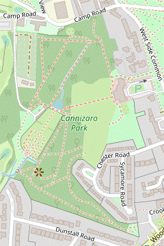
- At the far end cross a road (Southside Common) onto Wimbledon Common. Turn left onto the second of two broad sandy paths to go along the southern side of Rushmere Pond. After passing the pond bear right to reach the B281 (Cannizaro Road).
-
Cross the road and take either of two paths branching off to the left. Cross a road (West Side Common) and go through the right-hand of two entrance gates onto an enclosed path between flower beds into Cannizaro Park.
The left-hand entrance gate is for Cannizaro House, now the Hotel du Vin & Bistro.
-
Through Cannizaro Park (1¼ • 1¾ km)
-
Go past the Millennium Fountain into the main part of the park, where there is a small Gothic-style building (an Aviary) ahead on your right.
The fountain sculpture (by Richard Rome) is affectionately known as ‘The Teapot’. The aviary was based on the design of Turin Cathedral, but in May 2022 its condition had deteriorated and the birds have been rehoused elsewhere until a decision is made about its future.
-
Turn left and follow the path round to the dining area in the conservatory at the back of Cannizaro House, where there is a path going down the centre of the lawn.
- For a direct route through the park you can take this path directly away from the house, into trees at the bottom and past a pond on the right. If you take this direct route (saving 750m), resume the directions at [?].
-
For the suggested route carry on past the house. On the left is a formal Sunken Garden (with a small Herb Garden beyond its far corner). Follow the path round to the right and then veer left across a lawn to the opposite corner. Take the left-hand of two paths into Lady Jane's Wood.
This wood has been planted with rhododendrons, azaleas and camellias, so is particularly colourful in spring.
- For a small short cut (saving 300m) you can fork right at the first path junction inside the wood and resume the directions at [?].
-
For the full route fork left to go through the Mediterranean Garden, which leads to a Belvedere (with a small secluded area beyond it, The Retreat). Loop round behind the belvedere to return on a parallel and slightly lower path, which the short cut later rejoins from the right.
The belvedere (designed by James Berry of Merton Council) no longer has much of a ‘beautiful view’.
- After the main route merges with the short cut keep left at subsequent path junctions to stay near the southern edge of the wood. In the south-western corner you cross a small stone bridge over a stream in the Water Garden.
-
Follow the path round to the right to walk alongside the stream. The path leads to a gate into the Italian Garden.
This walled garden was originally the kitchen garden for the house.
- Unless it is closed for an event (when you would have to skirt around it), make your way through this walled garden. Leave through a gate on the far side and turn left in front of a pond, joining the direct route from the house.
- At the corner of the pond there is a path junction, with Cannizaro Studios ahead on the left. Unless you want to explore the northern part of the park, keep ahead and join a stony track curving round to the right to the park's back gate.
-
Optional Extension (+500m)
- For the extension turn right at the path junction by the corner of the pond and follow the path gently uphill along Chestnut Avenue.
-
At the top cross over a path and veer left in front of a neo-gothic building to come to a small Rose Garden.
This area (including the Rose Garden) was once part of a neighbouring property, with the neo-gothic building being the home of a priest.
-
Leave the Rose Garden through an opening on the left and turn right to come to a statue of Diana and the Fawn.
The statue was created in 1841 for a Sicilian villa.
- Turn left and follow a path back downhill towards the Studio area, merging with Maple Avenue from the Rose Garden. Towards the bottom you can veer right across a patch of grass to the park's back gate.
-
Cannizaro Park to Beverley Brook (1½ km)
-
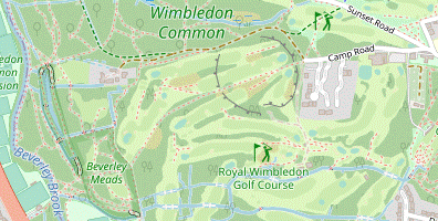
Leave Cannizaro Park and follow the track past allotments to a T-junction with Camp Road. Turn left and follow this lane for 350m, passing the clubhouse of the Royal Wimbledon Golf Club on the left and later the entrance gates to several large properties.
There is a different golf course (Wimbledon Common & London Scottish) off to the right of Camp Road. This is on open-access land and their players are required to wear “pillar-box red” shirts so that the Rangers who patrol Wimbledon Common can distinguish golfers from the general public.
-
Where the lane turns sharply right towards Warren Farm keep ahead on a narrow fenced footpath (known as the ‘Toast Rack’) to the right of a locked fieldgate, through an area shown on maps as Caesar's Camp.
A large plaque on the right of the path indicates that this is a misnomer, since you are actually crossing the site of an Iron Age hill fort dating from around 700 BC.
- Follow this public footpath all the way through the Royal Wimbledon Golf Course for 750m, gently downhill and with a few slight left turns along the way. At a four-way junction go through a gap in the chainlink fence ahead onto a narrow path through a wooded part of Wimbledon Common, slightly to the right of your previous direction.
-
The suggested route is to stay on this path (which is the continuation of the public footpath) as it goes gently downhill for 250m, heading towards an all-too-audible main road (the A3).
- If you are feeling adventurous you could explore one of the side paths off to the right of the public footpath, either through Beverley Meads or a boardwalk through Fishpond Wood. There is a maze of paths to negotiate but if you keep left at subsequent junctions you will eventually meet the riverside path further along.
-
On the suggested route the footpath comes to a semi-open area in front of a substantial footbridge over Beverley Brook, with playing fields off to the left and the A3 less than 200m ahead.
Beverley Brook is a short river, flowing from Worcester Park into the River Thames between Hammersmith and Putney. In medieval times there were beavers in the river and the name means ‘beaver-meadow stream’.
-
Beverley Brook to Roehampton Gate Café (4 km)
-
Whichever route you took down to the river turn right onto the Beverley Brook Walk (BBW) on its eastern bank.
This walk follows the BBW for the next 6 km, but then takes a different route across Barnes Common and Lower Putney Common.
-
Follow the riverside path for (up to) 1¾ km, skirting around any waterlogged patches as best you can and ignoring a couple of bridges across the river. There is woodland on your right until the final 300m, where you go alongside a large playing field and briefly join the Capital Ring.
The Capital Ring is a circular walking route around inner London. It was completed in 2005.
-
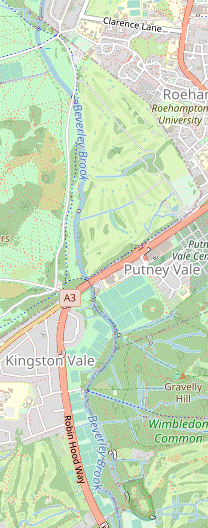
With a sports pavilion (and toilets) ahead, turn left to cross the river. Follow the waymarked path curving slightly to the right across a small open area to the A3 and cross this busy dual carriageway via the pedestrian lights.
The BBW is actually signposted across a high footbridge off to the left, presumably because the lights were installed after the route was devised.
-
Take the short link road ahead (now closed to traffic) through Robin Hood Gate into Richmond Park. Inside the park keep right, leaving the Capital Ring and curving round in front of a car park. At a signposted path junction the suggested route is to turn right towards Chohole Gate, staying on the BBW.
- The Tasmin Trail ahead is a slightly more direct route, but this 12 km perimeter track around Richmond Park is popular with cyclists and runners.
-
Before reaching a footbridge over Beverley Brook veer left across the grass to join the riverside path for an attractive section through open parkland, interspersed with a few lightly-wooded stretches. The Tasmin Trail is never far away on the left and in 1 km the two routes finally merge.
- A parallel grassy path alongside a wooden fence would let you delay joining the perimeter track until it crosses the river.
-
In 250m follow the Tasmin Trail across the river and continue along it for a further 400m, keeping to the left of a large car park. Just past its entrance you come to an area laid out with picnic tables in front of the Roehampton Gate café, a possible refreshment stop.
If you want a quieter spot there is a small fenced garden with a few benches 150m further along the walk route.
-
Roehampton Gate Café to Barnes Bridge Station (2¾ km)
- From the café return to the Tasmin Trail, soon going alongside the small garden mentioned above (with its entrance gate halfway along). Cross the road ahead carefully, turn right and leave Richmond Park through Roehampton Gate.
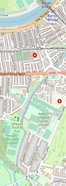
- Outside the park immediately turn left onto an enclosed footpath running alongside its boundary wall, staying on the BBW. After crossing the river turn right onto the riverside path (or walk along the edge of the adjacent Palewell Common & Fields).
- In 400m ignore a footbridge over the river and follow the path round to the left. At a Y-junction fork right to stay alongside the river. After passing another footbridge the path swings left and goes out between allotments to a residential street (Hertford Avenue).
- Turn right onto the road and go all the way along it, passing a school on the left. At the far end turn right onto the A205 (the South Circular Road). Cross over this main road at the first or second set of pedestrian lights and then fork left into Priests Bridge. Almost immediately turn left into Fitzgerald Avenue, leaving the BBW.
-
In 125m turn half-right to stay on this road, avoiding the cul-de-sac ahead (Buxton Road). At the end of Fitzgerald Avenue turn left onto White Hart Lane, soon crossing the railway at a level crossing.
- This is a busy line and the road crossing sometimes remains closed for several trains to pass, but there is a footbridge which you can use.
- On the right you pass the first of several pubs in the area, The Crossing. At the end of the road bear right at a mini-roundabout and cross The Terrace in front of Ye White Hart on the south bank of the River Thames.
-
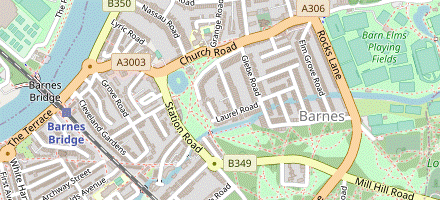
From the pub join the Thames Path, with the river on your left. Follow the path under Barnes Railway Bridge, with Barnes Bridge station on the right.
The three spans of wrought iron girders were constructed in the 1890s to replace a cast iron bridge. Doubts had been raised about the stability of those structures after several had collapsed, including one on the Brighton main line in 1891. As you walk under it you can see part of the original 1849 bridge which was left in place alongside the new one; there are plans to convert it into a garden walkway.
-
Finishing at Barnes Bridge Station
- To complete the Short Walk go up the steps on the far side of the bridge, signposted to Platform 1 for trains to Waterloo.
-
Barnes Bridge Station to the Old Cemetery (1½ km)
-
Carry on past the railway bridge, either along the raised walkway overlooking the river or The Terrace's pavement.
There is a blue plaque at #12 to the composer Gustav Holst (1874-1934), best known for his orchestral suite “The Planets”.
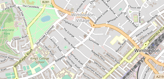
- At the next mini-roundabout two more riverside pubs are directly ahead (the Watermans Arms and the Bulls Head), but to continue the walk turn right into Barnes High Street. The refreshment choices along this street include the Coach & Horses pub, a Caffè Nero and a Pizza Express (all on the right-hand side).
- The High Street ends at a roundabout, with the Sun Inn the first building on Church Road to the left, and Station Road ahead on the right. To continue the walk cross the road and take the broad path between the village pond and Station Road.
-
At the corner of the pond bear slightly left onto a tarmac path going straight across Barnes Green. On the far side cross a footbridge over Beverley Brook and turn half-left onto another long straight path across Barnes Common, rejoining the BBW.
Barnes Common has become dissected by roads and the railway. The 100-acre site of rough grassland and woodland was designated as a Local Nature Reserve in 1992.
- The path gradually approaches Mill Hill Road on the right, but 60m before reaching it turn half-left again at an oblique path crossing. Follow this path for a further 300m to the far side of the common. Go out through the tree boundary onto the A306 (Rocks Lane), with a Sports Centre opposite.
-
Your onward route is to the right of this centre, but it is advisable to cross the road at the pedestrian lights on the left and take the tarmac path coming back alongside a tree-lined lane, passing the centre's car park on your left. At the end of its fence veer left through a small car park to come to an information panel in front of a wooded area.
After Barnes Common Old Cemetery closed for burials in 1954 it became increasingly neglected and is now completely overgrown. It was designated as part of the Local Nature Reserve in 1980 and is maintained by the Friends of Barnes Common.
-
The Old Cemetery to Putney Stations (2½ km)
- Take the narrow path ahead into this gloomy cemetery. You should aim to leave near its far right-hand corner, and if you zig-zag right and left at the first opportunity you will join the central aisle through the site of the Mortuary Chapel and past the Hedgman Memorial.
-
Leave the cemetery via one of the narrow paths near its south-eastern corner and head E through a wide gap in the trees ahead, passing a wooden post indicating that you are going from Barnes Common onto Putney Lower Common.
There is no clear division between these two commons but they are in different London Boroughs. Although widely separated from them, Putney Lower Common is managed with Wimbledon Common and Putney Heath.
- Continue to head E for around 150m. On emerging into a large open space bear left onto a faint grassy path heading ENE towards a gap in the tree boundary, 125m away. Go through this and join a tarmac path heading NNE across a patch of scrubland.
- On the far side go back across Beverley Brook on a bridge. Turn right onto a broad path, with the tree-lined river on your right and the extensive playing fields of Barn Elms Sports Centre on your left.
- In 350m the path swings left and right to skirt around Ashlone Wharf. The Beverley Brook Walk ends on the Thames embankment, with a view across the river to Fulham's football ground, Craven Cottage.
-
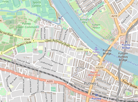
Turn right onto the Thames Path, crossing the outflow of the tributary whose course you have been following. Follow Putney Embankment all the way to Putney Bridge, passing Leader's Gardens (a small urban park with a café) and later a string of boathouses.
For the Boat Race the Oxford crews use Imperial College (women) and Westminster School (men); the Cambridge crews use Thames Rowing Club (women) and King's College School (men).
-
Shortly before reaching the bridge you pass Putney Pier and the back of two large pubs on Lower Richmond Road, the Duke's Head and the Star and Garter.
- The suggested refreshment places are on the other side of the A219 at Putney Bridge: the Putney Pantry is in the grounds of St Mary's church, with The Rocket and The Boathouse pubs just beyond it.
-
Finishing at Putney Station
- Go up Putney High Street, away from the river. The entrance to the mainline station is on the left-hand side of this traffic-clogged main road, just before the major junction with the South Circular Road.
-
Finishing at Putney Bridge Station
- Cross the river on Putney Bridge. At the pedestrian lights by All Saints church turn right into Gonville Street, which leads directly to the underground station.
The suggested route is a loop through the southern half of this small park, with an optional extension around the other half. You could of course devise your own route from the detailed map displayed at the entrance.
⬅ North (map rotated 90°)
⬅ North (map rotated 90°)
Complete the walk at [?] for trains to Waterloo, or [?] for the District line.
» Last updated: May 2, 2023
Return to Top | Walk Map | Walk Options | Walk Directions.