Arlesey to Letchworth Garden City walk
Achalk stream, the Greensand Ridge, the ‘Cathedral of the Chilterns’, a motte-and-bailey and abandoned medieval village, the Icknield Way past a lavender farm to a Garden City.

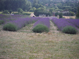
Main Field, Hitchin Lavender (Cadwell Farm), from bridleway north of farm
SWC Walk 233 - Arlesey to Letchworth Garden City
Jul-17 • thomasgrabow on Flickr
swcwalks swcwalk233 banner 35597084090

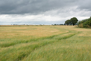
Big Skies and Long Views in Hertfordshire
SWC Walk 233 - Arlesey to Letchworth Garden City
Jul-17 • thomasgrabow on Flickr
swcwalks swcwalk233 walkicon 35815719952

Meppershall Manor House
SWC Walk 233 - Arlesey to Letchworth Garden City
Jul-17 • thomasgrabow on Flickr
swcwalks swcwalk233 walkicon 35853999031

All Saints' Church, Shillington, from footpath
SWC Walk 233 - Arlesey to Letchworth Garden City
Jul-17 • thomasgrabow on Flickr
swcwalks swcwalk233 walkicon 35815549642

Thatched House, Pirton
SWC Walk 233 - Arlesey to Letchworth Garden City
Jul-17 • thomasgrabow on Flickr
swcwalks swcwalk233 walkicon 35175911823

Near Arlesey
Arlesey to Letchworth Garden City
Jul-16 • Cymbidium Clarisse on Flickr
nikon hiking walk hike letchworth nikondigital englishcountryside countrywalk swc arlesey countrysidewalk nikon1 swcwalks nikon1j2 swcwalk233 saturdaywalkersclub 27635081484

Near Arlesey
Arlesey to Letchworth Garden City
Jul-16 • Cymbidium Clarisse on Flickr
city club garden nikon hiking walk saturday hike letchworth walkers nikondigital englishcountryside countrywalk swc 233 arlesey countrysidewalk nikon1 swcwalks nikon1j2 swcwalk233 saturdaywalkersclub 28216320626
| Length | 25.4 km (15.8 mi), with 200/156m ascent/descent. For a shorter or longer walk see below Walk Options. |
|---|---|
| Toughness | 4 out of 10, with 5 hours 30 minutes walking time. For the whole outing allow at least 8 hours. |
| Walk Notes | This not too challenging walk in the Bedfordshire/Hertfordshire borders leads straight from the platform into the wildlife-rich riverside meadows of the Hiz River, a meandering high quality chalk stream, followed for a few km. It then leads west along field boundaries and through RAF Henlow Camp to the linear hilltop village of Meppershall, past its manor house and a motte-and-double bailey. The following stretch offers far views south to the Chilterns and north to the Greensand Ridge, before heading to the imposing hilltop church in Shillington, dubbed the ‘Cathedral of the Chilterns’ by John Betjeman. After lunch green lanes lead to the pretty village of Pirton, with more impressive remains of a motte-and-double bailey and traces of an abandoned medieval village.
The Icknield Way leads you to one of the very few British lavender farms and then to the World’s first and Britain’s best Garden City: Letchworth. |
| Walk Options | An optional – flat – Extension right at the start adds 2.2 km.
Mutually exclusive Shortcuts around lunch reduce the length of the walk by either 3.0 or 1.4 km. An infrequent bus service (lines 79 and 89, Mon-Sat only) gets you from Meppershall, Shillington and Pirton to Henlow Camp, where you can connect to the more frequent service to Hitchin. That bus can also be caught 5 km from the end, on the A600. < |
| Maps | OS Explorer: 193 (Luton & Stevenage)
OS Landranger: 153 (Bedford & Huntingdon) and 166 (Luton & Hertford) |
| Travel | Arlesey station, map reference TL 190 378, is 8 km north of Hitchin, 39m above sea level and in Bedfordshire. Letchworth station, map reference TL 217 328, is 5 km north east of Hitchin, 84m above sea level and in Hertfordshire. It is on the London Kings Cross to Peterborough East Coast Main Line but is also served by Thameslink trains via St. Pancras International. Trains usually call at Finsbury Park. Journey times are 40 minutes Mondays to Saturdays (two Thameslink trains per hour), and 37 minutes on Sundays (hourly King’s Cross service). Letchworth Garden City is on the London Kings Cross to Cambridge Main Line, the first stop after branching off from the East Coast Main Line at Hitchin, but also served by Thameslink trains from Cambridge. Journey times are 37 to 51 minutes (two to four trains per hour). Buy a return to Letchworth Garden City. You may then have to buy a Hitchin-Arlesey ticket on board the train.
Saturday Walkers’ Club: Take the train closest to 9.30 hours (assuming travel from St. Pancras). |
| Lunch | The Crown 104 High Road, Shillington, Hitchin, Bedfordshire, SG5 3LP (01462 711 667). The Crown is located 11.3 km (7.0 mi) into the main walk and is a family run country pub and restaurant with log fires in winter and a large garden in summer.
|
| Tea | Plenty of tea options in Pirton, in Ickleford and at the Lavender Farm, and then in Letchworth. See the pdf for details. |
| Profile | |
|---|---|
| Help Us! |
After the walk, please leave a comment, it really helps. Thanks! You can also upload photos to the SWC Group on Flickr (upload your photos) and videos to Youtube. This walk's tags are: |
| By Train |
Out (not a train station) Back (not a train station) |
| By Car |
Start SG15 6XA Map Directions Return to the start: Finish SG6 3AN Map Directions Travel to the start: |
| Amazon | |
| Help |
National Rail: 03457 48 49 50 • Traveline (bus times): 0871 200 22 33 (12p/min) • TFL (London) : 0343 222 1234 |
| Version |
Apr-24 Thomas G |
| Copyright | © Saturday Walkers Club. All Rights Reserved. No commercial use. No copying. No derivatives. Free with attribution for one time non-commercial use only. www.walkingclub.org.uk/site/license.shtml |
Walk Directions
Full directions for this walk are in a PDF file (link above) which you can print, or download on to a Kindle, tablet, or smartphone.
This is just the introduction. This walk's detailed directions are in a PDF available from wwww.walkingclub.org.uk
