Brockenhurst to Lymington Walk
A varied walk on the southern edge of the New Forest through parkland, woods, open heaths and pasture before a contrasting finish past coastal marshes.


CIMG4335
Heathland near Shirley Holms
Aug-14 • Sean O'Neill
swcwalk226, swcwalks, walkicon 6057752912397860690 P
CIMG4507
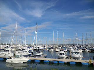
Lymington Yacht Haven
Aug-14 • Sean O'Neill
swcwalk226, swcwalks, walkicon 6057754518255704578 P
CIMG4262
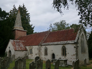
St Nicholas church, Brockenhurst
Aug-14 • Sean O'Neill
swcwalk226, swcwalks 6057752056092039858 P
| Length |
Main Walk, to Lymington Town: 20¼ km† (12.6 miles). Four hours 35 minutes walking time. For the whole excursion including trains, sights and meals, allow at least 10 hours. Longer Walk, via Keyhaven: 25 km† (15.5 miles). Five hours 40 minutes walking time. Shorter Walk, from Lymington Pier: 16½ km†‡ (10.3 miles). Three hours 35 minutes walking time. Alternative Walk, from Lymington via Keyhaven: 21¼ km†‡ (13.2 miles). Four hours 40 minutes walking time.
† Add 1½ km (1 mile; 25 minutes) if returning from the Pier station. See Walk Options below.
|
|---|---|
| OS Map |
Explorer OL22 (or OL29). Brockenhurst, map reference SU301020, is in Hampshire, 15 km SW of Southampton. |
| Toughness |
3 out of 10 (4 for the Longer Walk, 2 for the Shorter Walk). |
| Features |
Although a good part of this walk is within the New Forest National Park, there are only occasional encounters with the remote heathland or dense woodland which you might expect. Some of the walk's first section is in fact through the landscaped parkland of a now-demolished country house, Brockenhurst Park, and it continues along pleasant broad tracks through Roydon Woods. Shortly after leaving this nature reserve you come to a possible early refreshment stop on the main road between Setley and Battramsley. The next section includes the walk's one stretch across wide open heathland at Shirley Holms, with fine views across the gorse and heather. The walk then becomes less distinctive for a while as it leaves the National Park to continue past farms and stables with occasional glimpses of the Isle of Wight. After crossing the A337 at Efford Bridge the Main Walk heads south-east to the suggested lunch pub in Chequers Green. The final section to the attractive sailing resort of Lymington is quite different in character. You walk along embankments past the extensive saltmarsh and mudflats of Lymington–Keyhaven Marshes, with magnificent views of the Isle of Wight across the Solent. This nature reserve is now a haven for wildlife but in the 18thC it was the site of the Lymington Saltworks, the country's leading supplier of sea salt. This profitable industry only ceased (in 1865) when salt could be obtained more cheaply from mines in Cheshire. There are no opportunities for swimming in the sea but the route goes past Lymington's open-air Sea Water Baths which are open daily in summer to 6pm; admission (2024) is £4.50. At the end of the walk a lucky few might be allowed to sip pink gins at one of the town's exclusive yacht clubs, but there are plenty of other places willing to serve hoi polloi before the longish journey home. |
| Walk Options |
Two options were added to this walk in 2024. From Efford Bridge the Longer Walk heads south through a large wood and across farm fields to Keyhaven, which allows for an extended stretch alongside the coastal marshes which are its most distinctive feature. Although not included in the directions, you could also make an out-and-back extension along the shingle spit to Hurst Castle (or use the summer ferry link in one or both directions). The Shorter Walk is a (near) circular walk from Lymington. If you take the longer start from the Pier station it goes past the impressive Walhampton Monument in the style of an Egyptian obelisk, then crosses the wide Lymington River to join the short link route from the Town station. It continues through a long (and potentially awkward) stretch of wet woodland in Lymington Reedbeds and crosses the site of a small Iron Age hill fort called Buckland Rings before joining the Main Walk route. These two options can be combined to make an Alternative Walk, which only has 6¼ km in common with the Main Walk. The directions from Lymington Pier are described in reverse to provide a small optional extension at the end of the walk, and some minor short cuts are available in all the walk options. |
| Transport |
Brockenhurst has a half-hourly semi-fast service from Waterloo (hourly Sun) taking about 1 hour 30 minutes. Lymington is on a short branch off the main line at Brockenhurst, with a station in the town and another across the river at the ferry terminal. The half-hourly service generally connects well with the Waterloo trains, but the return journey is still at least 20 minutes longer. Buy a return to Lymington Pier (or Town; the fare is the same). If you want to abandon the walk Bluestar 6 runs hourly (two-hourly Sun) along the A337 between Brockenhurst and Lymington; you could also use it to start the walk from Battramsley. Further on there are more bus routes along some of the other roads into Lymington, but none once you have gone beyond Efford Bridge. |
| Suggested Train |
Take the train nearest to 09:00 from Waterloo to Brockenhurst (or 10:00 if you are planning an early lunch stop; see below). |
| Train Times |
|
| Timetables |
|
| River Levels |
|
| Lunch |
The suggested lunch pubs on the Main & Longer Walks are a long way from Brockenhurst, but you could have a mid-morning refreshment stop – or a very early lunch – in Battramsley (after 4¼ km), where the Hobler Inn has been transformed into Rosie Lea House (01590-622908). This “rustic restaurant” has an attractive garden and serves breakfast to 11.30am, lunch from noon to 5pm. The suggested pub on the Main Walk (after 13¼ km) and Shorter Walk (9½ km from Lymington Pier) is the Chequers Inn (01590-673415) in Chequers Green. This is a friendly pub with food served to 2.15pm on weekdays, all afternoon at weekends. The suggested pub on the Longer Walk (after 15 km) and Alternative Walk (11¼ km from Lymington Pier) is The Gun Inn (01590-642391) in Keyhaven. On the coast path near the harbour, this equally good pub serves food to 4.30pm. As there is a long gap after Battramsley directions are given for a 1¼ km detour to the New Wheel Inn (01590-688953) in Gordleton (8¼ km from Brockenhurst), although this has not been tried since it was taken over and completely refurbished in 2020. Previous versions of this walk included a detour to The Musketeer in Pennington, but this has closed. However, the nearby common is a possible picnic spot. |
| Tea |
If you have an early lunch stop the Chequers Inn or The Gun Inn (see above) would make convenient mid-afternoon tea stops. At the end of the walk there are plenty of refreshment places in Lymington, including cafés and kiosks as you enter the town. The Ship Inn (01590-676903) has a prominent location on Town Quay and the Kings Head (01590-672709) is a little way back from the river, in Quay Hill. You won't have any difficulty sniffing out the local chippie if you want a traditional seaside meal before the journey home. If you have to wait for a train the nearest pub to the Town station is the Bosun's Chair (01590-675140) in Station Street. On the extension the Curlew Café (0333-999 7333) in the Ferry Terminal next to the Pier station is normally open daily to 6pm. |
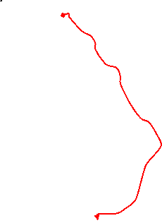
| Profile | |
|---|---|
| Help Us! |
After the walk, please leave a comment, it really helps. Thanks! You can also upload photos to the SWC Group on Flickr (upload your photos) and videos to Youtube. This walk's tags are: |
| By Train |
Out (not a train station) Back (not a train station) |
| By Car |
Start Map Directions Return to the start: Finish Map Directions Travel to the start: |
| Amazon | |
| Help |
National Rail: 03457 48 49 50 • Traveline (bus times): 0871 200 22 33 (12p/min) • TFL (London) : 0343 222 1234 |
| Version |
Sep-24 Sean |
| Copyright | © Saturday Walkers Club. All Rights Reserved. No commercial use. No copying. No derivatives. Free with attribution for one time non-commercial use only. www.walkingclub.org.uk/site/license.shtml |


Walk Directions
Click the heading below to show/hide the walk route.


 Walk Maps
©
Walk Options
Click on any option to show only the sections making up that route, or the heading above to show all sections.
- Main Walk (20¼ km)
Walk Directions
Click on any section heading to switch between detailed directions and an outline, or the heading above to switch all sections.
If you are doing the Shorter or Alternative Walk (from Lymington), start at §C.
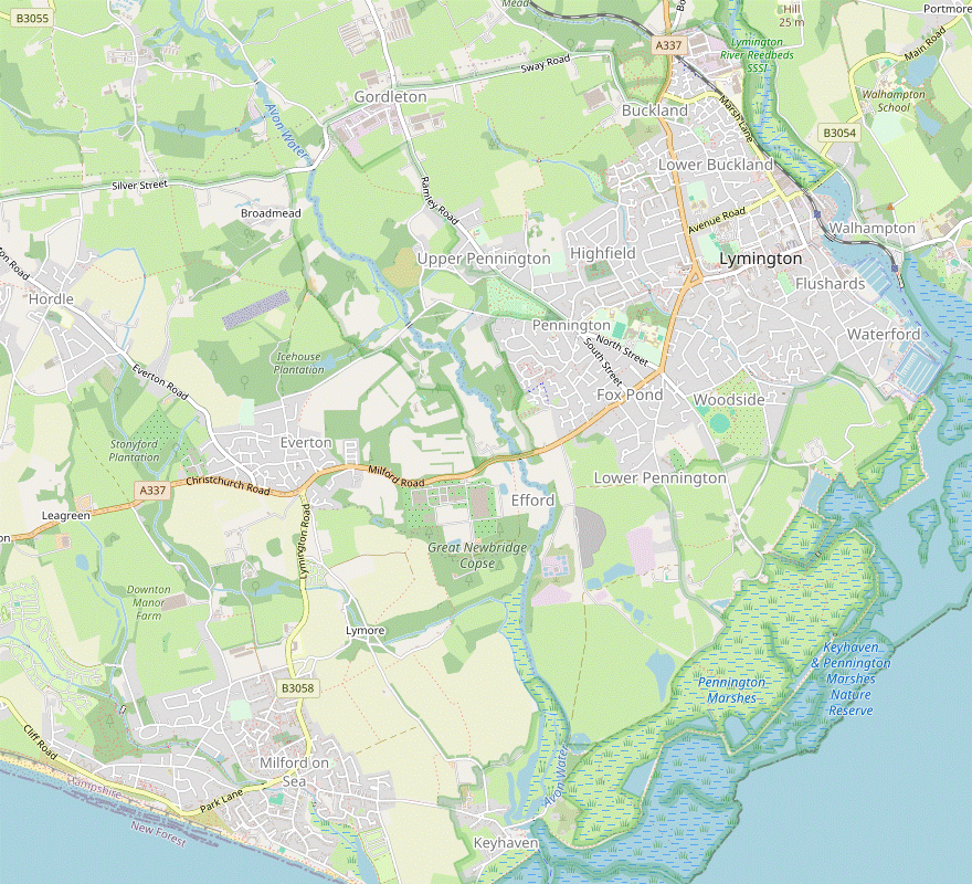
- Brockenhurst Station to Battramsley (4¼ km)
- Leave the station and turn right onto the A337, then fork left onto Church Lane. 200m after passing St Nicholas church turn left onto a bridleway and follow this through Brockenhurst Park and Roydon Woods. After passing Roydon Manor fork right onto a bridleway to Sandy Down. Keep ahead on a footpath crossing several minor roads to come to Rosie Lea House on the A337.
- From the platform go up steps to the overhead bridge and turn right to leave the station through the car park on its south side, coming to the A337 with Mill Lane opposite. Turn right onto the main road, heading S (away from the town) and crossing over carefully at some point.
- In 50m fork left onto Church Lane, signposted to St Nicholas Parish Church and soon climbing gently. In 200m you pass the New Zealand Cemetery? on the left, with an information panel “Brockenhurst – A First World War Hospital Village”.
- After a further 150m you come to St Nicholas? church, and the suggested route is to go through its churchyard. On the way out through its main gate you pass another information panel, “New Zealand in the UK during World War Ⅰ”.
- Continue along the lane for another 200m, round some right-hand bends, then turn left onto a signposted bridleway. Follow this broad path between hedges with the parkland of Brockenhurst Park? on both sides.
- In 200m go through a gate into Roydon Woods? and continue along the main path, initially still with the parkland on your left and later veering into the wood, crossing a few streams along the way.
-
In 1 km you pass a patch of parkland on your left, then the path joins another bridleway coming in from the right. After passing an isolated cottage ignore the driveway to Roydon Manor? on the left. In 200m another bridleway branches off to the left.
- A 200m detour down this bridleway would give you a nice view of Roydon Manor and the Lymington River.
- Stay on the main bridleway for a further 200m, round a bend to the right. As the path curves back to the left turn right onto a signposted bridleway, heading SW and soon climbing gently.
- At the top of the slope follow the main path past a conifer plantation and out through a wooden side gate. Keep ahead across a patch of grassland to come out onto a lane, leaving the nature reserve.
- Cross over and take the footpath opposite, between high garden hedges and then down through a wood to another lane. Again take the footpath opposite, gently downhill through trees. At the bottom cross a stream on a wooden footbridge and continue up the left-hand side of two fields.
- In the top corner go over a stile onto an enclosed path along the edge of a wood and follow this for 300m (veering left along the way to avoid a private garden ahead). At the end you pass the garden of Rosie Lea House and come out onto the A337. Turn left onto the road to go past the front of the restaurant, an early refreshment stop.
- Battramsley to Yaldhurst Stream (4¼ km)
- Take the footpath opposite the restaurant which leads to a corner of heathland. Keep ahead to cross over the branch line and make a long curve round to the left to Shirley Holms. Head for a footpath in the south-east corner of this piece of heathland and follow this past Mount Pleasant Farm. Cross Mount Pleasant Lane and continue on a footpath past Setters Farm. Cross Sway Road onto the continuation of the footpath. Shortly after passing Yaldhurst Copse turn right towards a footbridge across Yaldhurst Stream.
- To continue the walk cross the A337 carefully and take the footpath opposite the restaurant's car park, going over a stile to the right of a house. The path goes between hedges for 350m, then another stile takes you onto the corner of open heathland.
- Continue in the same direction alongside a hedge. At the end pass to the right of a house and then keep left at a triangle of tracks. You pass another large house “The Hob” on your right, then fork right down a gravel track which takes you across a bridge over the Lymington branch line?.
- Go past a row of cottages on your left, on the grass to the right of the track if you prefer. Where the track turns left by the last cottage, keep ahead across the grass to join a broad track climbing up through the heath. Follow this round a gentle left-hand curve to reach a lane by a Forestry Commission sign for Shirley Holms?.
- Cross the lane and keep ahead on the heath to the right of the car park entrance. Continue on a grassy track alongside the wood on your left for 600m, gradually curving round to the left and with views across a valley on the right.
- You eventually come to a cluster of houses at a corner of the heath where you turn right onto a gravel driveway heading S. In 150m the drive swings right in front of some more houses, but you bear left to find a stile in the corner, to the left of a thatched house “Widden”.
- Follow the footpath between fences, over a stream on a wooden footbridge and along the side of a field. In the far corner go over a stile and turn half-right as indicated to go up a wide strip of grass, alongside a fence on your left.
- Ignore a track off to the left and go up to the top to find a stile in the fence, which takes you past a garden and its house to a lane. Follow the path past a row of cottages to reach Mount Pleasant Lane.
- Turn left briefly onto the lane. In 25m turn right onto a signposted footpath, along a driveway. At the end keep left to continue through a belt of trees. Follow this slightly awkward footpath for 250m past some new houses, ignoring another footpath off to the right along the way.
- The path then turns left and you will be heading in this direction for 600m, initially on a fenced gravel track between paddocks. Where the track turns left after 200m, keep ahead through a small wicket gate to continue on a grassy track.
- As you approach another new house the path goes up a small bank and continues through a belt of trees. For the last part of this stretch keep left (where a gap on the right leads into a private garden) to go along a driveway to Sway Road. Unless you want to detour to the pub in Gordleton, cross the road carefully onto the continuation of the footpath.
-
Detour to the New Wheel Inn (+1¼ km)
- Turn right and go along Sway Road for 600m. The pub is on the far side of the crossroads with Ramley Road. Return the same way and turn right onto the footpath.
- After a few turns to get around gardens the footpath emerges into more open countryside. Follow this narrow (and potentially overgrown) fenced path for a further 600m, soon with a long belt of trees (Yaldhurst Copse) on the right. Shortly after the end of these trees turn right at a footpath signpost, towards a wooden footbridge.
- Lymington Pier • Town Station to Bridge Road (1¼ • ¼ km)
-
From the Pier station, go through the car park and up Monument Lane. Go past the Walhampton Monument and take the footpath going back downhill. Turn right onto Undershore Road, then turn left onto the B3054 to cross the Lymington River. Turn right onto the footpath just before the level crossing.
- From the Town station, turn right onto Waterloo Road to reach the B3054. Go over the level crossing and turn left onto the footpath.
-
Starting from Lymington Pier Station (1¼ km)
- Leave the station from the front of the platform and turn sharp left to go back past the side of the Ferry Terminal building (with its Curlew Café). Make your way onto the walkway along the right-hand side of the car park and go out onto Undershore Road.
- Cross the road to go up Monument Lane opposite, joining the Solent Way? (SW) from a footpath on the right halfway up the hill. At the top turn left through a gap in the fence onto a small clearing containing the Walhampton Monument?.
- On the far side of the monument take the footpath going back down the wooded hillside. At the bottom bear right to continue along Undershore Road, with a view of the town across the wide Lymington River.
- In 300m turn left onto the B3054 (Bridge Road) to cross the river. Just before reaching the level crossing turn right onto a signposted footpath, leaving the SW.
-
Starting from Lymington Town Station (¼ km)
- Go out through the station forecourt to a crossroads and turn right, into Waterloo Road. At the end turn right onto the B3054 (Bridge Road) to go over the level crossing, then immediately turn left onto a signposted footpath.
- Bridge Road to Yaldhurst Stream (3½ km)
-
 Follow the footpath for 1½ km: alongside Lymington Reedbeds, past the back of a hospital and round an industrial estate. At the far end turn left onto Boldre Lane to come to a T-junction with the A337. Turn left and cross the main road at the roundbaout. Immediately after going under the railway bridge turn right onto a footpath going up steps into the north-eastern corner of Buckland Rings. Take any route through this Iron Age hill fort to leave in its south-western corner. Take the footpath opposite heading south-west for 800m, then turn left towards a footbridge across Yaldhurst Stream.
-
For the main route, go over some metal steps onto the long straight footpath, hemmed in between an ugly iron structure protecting the railway and a belt of trees affording only occasional glimpses of Lymington Reedbeds?. In 500m there are some more steps to negotiate and the path starts to curve away from the railway.
The right of way used to come in across the tracks here from Marsh Lane, but Network Rail closed the level crossing and substituted the 500m stretch from Bridge Road.
-
In the next 750m the path goes through a potentially waterlogged stretch of wet woodland, past the back of Lymington New Forest Hospital and then gradually curving to the left around Ampress industrial estate. It eventually comes out onto a water company site's access road at a bend.
You might be tempted to cut through the industrial estate to the left, but you would have to hurdle a padlocked fieldgate to escape and in any case the final 500m of this right of way is less problematic.
- Turn right onto the road and go up to the metal gates in front of the site. Take the fenced path to their left and follow it around the northern part of the industrial estate, crossing a stream on a footbridge along the way. The path eventually emerges onto Boldre Lane where you turn left to come to its T-junction with the A337, with a roundabout on the left and a railway bridge beyond it.
- If you stay on this side of the A337 (crossing Wellworthy Road at the roundabout) there is a pavement the whole way, but crossing the busy main road by the railway bridge is very awkward, with a restricted view of traffic coming from the roundabout. It is not much better, but the suggested route is to cross the A337 at the roundabout and make your way carefully along the right-hand side of the main road.
-
Immediately after going under the bridge go past a safety barrier onto the signposted public footpath, climbing steps cut into the steep bank. Where the path levels out turn left up a short flight of wooden steps, entering Buckland Rings?.
The meandering route through this Iron Age hill fort takes in both the open interior and its double-ditched defensive ramparts.
- For the suggested route bear right from the top of the steps to go along a wooded ridge between two large pits, with the one on the right now used by BMX riders. Ignore a gate into the meadow on the left and follow a path along the edge of the woodland, soon curving away from the meadow.
- Keep left at path junctions to go back towards the meadow, but in front of the remaining part of the site's eastern rampart turn right onto a path running along its upper ditch. Follow the path round to the left to continue alongside the northern rampart. At the end turn left up a short flight of wooden steps.
-
Go through a gate into the north-western corner of the site's interior and take the grassy path going diagonally across the meadow, heading SE. On the far side go through another gate and down the slope of the wooded southern rampart.
- There are paths off to the left along the upper and lower ditches, which connect at the far end. For a short extension (+250m) you could go out along the upper path and return on the lower path.
- At the bottom go out through a gate into another meadow. Turn half-right and take the grassy path heading SW to a gate in the corner, 125m away. You emerge onto a fairly busy road (Sway Road) on the inside of a bend, so cross the road carefully and take the right-hand of two driveways opposite, signposted as a footpath.
-
In 100m bear left and then right to stay on the right of way, as indicated by some inconspicuous footpath waymarkers in this new development. After the houses keep ahead past the right-hand side of a large corrugated-iron shed onto a fenced path between fields, ignoring another footpath branching off to the left. In 450m turn left at a footpath signpost, towards a wooden footbridge.
- Yaldhurst Stream to Efford Bridge (2½ km)
- Cross the stream and follow the footpath around field edges, then continue in the same direction on Yaldhurst Lane. At the end of this lane bear right and cross over Ramley Road onto Pennington Common. Head south-west across the common and take a footpath alongside a housing estate to the A337. Turn right briefly onto the main road, towards Efford Bridge across Avon Water.
- Cross Yaldhurst Stream and follow a wide fenced path around the edges of some large fields, turning right and then left along the way. After going through a metal kissing gate keep ahead along one more field edge, ignoring another footpath off to the right. Near the end go through a kissing gate on the left to continue on the tarmac lane you have been walking alongside, away from the entrance to Waldhurst Farm House.
- You now simply follow this lane for 400m. There are fields and later a recreation ground behind trees on your left, and houses on the right. At the end you come to a small green and bear right to reach Ramley Road.
- Cross the road carefully and take any convenient route across Pennington Common, aiming for the right-hand end of the row of houses opposite. On the far side cross a lane and take the driveway to the right of these houses, signposted as a footpath.
- Follow the path as it curves round to the right, then makes a sharp turn to the left. 200m further on, veer left in front of the gate for Furzey House onto a woodland path. Continue near the left-hand edge of this belt of trees for 200m, ignoring exits into the housing estate on your left.
- Shortly before one of these exits, with only a narrow path continuing ahead through the trees, turn right onto a path with some low wooden supports on its right-hand side. On the other side of the copse follow the path round to the left, with a fence on your right.
- In 200m the right of way is to keep right and go over a stile onto an enclosed path past some allotments, although as an alternative there is a broad strip of grass between the allotments and the footpath with an exit at the far end. Either way, continue on the fenced path for a further 250m to come out onto the A337 (Milford Road).
- Turn right and go alongside the busy main road, crossing over carefully as soon as you can to the footway on the far side. In 60m, shortly before the road crosses Avon Water on Efford Bridge, the driveway to “Eden” on the left is signposted as a footpath.
- Efford Bridge to Chequers Green (2¼ km)
- Take the first footpath on the left, before Efford Bridge. Follow it south and eastwards and go straight across a lane (Milford Road) to continue eastwards, joining Lower Pennington Lane at Sadlers Farm. Head south along the lane through the hamlet, then take the footpath on the left along field edges to the Chequers Inn on Ridgeway Lane.
- For the Main & Shorter Walks turn left onto the driveway, going through a side gate to the right of a metal fieldgate. After it curves round to the left go past the property's entrance gate and straight ahead into a meadow.
- Follow a faint grassy path across the meadow and through a gap in the tree boundary on the far side. Go over a stile into the corner of a field, turn right and go around two edges. In the far corner go over another stile and across a ditch onto a lane.
- The onward route is along the farm drive just off to the right, but the right of way (avoiding the fieldgate which is usually locked) is the short path opposite. This immediately turns right and crosses a footbridge to join the driveway behind the gate.
- After going along the drive for 200m fork left onto a shingle track, soon passing a wooden vehicle barrier. Later this becomes a green lane which leads onto a tarmac drive. Bear right as indicated and follow the driveway out to a minor road (Lower Pennington Lane), with Sadlers Farm opposite.
- Turn right onto the lane. In 200m you pass the entrance to Lower Pennington Farm House on the right. In a further 40m, just before the next driveway, turn left through a narrow gap in the hedge onto a signposted footpath.
- Go along the right-hand edge of a field for 100m. The path swings round to the right in the corner and you have to make your way across a potentially muddy patch in the tree boundary. Go over a stile to continue along a narrow and slightly awkward fenced path for 200m, with a right and left zig-zag along the way.
- At the far end go over another stile and across a driveway onto the triangular Chequers Green. Follow the lane on its left-hand side to come to the Chequers Inn on Ridgeway Lane.
- Chequers Green to Eight Acre Pond (3¼ • 1¼ km)
-
 Head south along Ridgeway Lane and Lower Woodside for 250m, then turn left into Lymington–Keyhaven Marshes. Turn right in front of Moses Dock onto the Solent Way (SW) and follow it alongside the inlet to a large sluice gate.
- For the full walk carry on past the gate for a 2 km loop around Oxey Marsh: following the SW for two-thirds of the way, turning right onto a footpath across the marsh and turning right again to return to the sluice gate.
-
Turn right out of the pub to head S on Ridgeway Lane (which becomes Lower Woodside). In 250m turn left into the second of two driveways (the one after Greek Cottage), as indicated by a footpath signpost across the road, and entering the area known as Lymington–Keyhaven Marshes?.
- It is unclear whether the signpost is pointing to the driveway or a parallel path in the adjoining belt of trees, but waymarkers further along the drive imply that it is a right of way.
- In 50m turn right off the driveway through a narrow gap with footpath waymarkers, joining the Solent Way? (SW). The path goes alongside Moses Dock?, with two derelict salt boiling houses? on the far side.
- Where the inlet turns sharply left go through a wooden gate and turn left to stay alongside it, with Oxey Marsh off to the right. Follow the path up to a large sluice gate across the inlet, which is the onward route to Lymington.
-
Loop around Oxey Marsh (+2 km)
-
Go past the sluice gate to continue along the embankment path, initially with the inlet on your left and then making several turns to the right. In 600m ignore steps off the embankment at a left-hand bend.
- Carry on along the sea wall for a further 700m, soon passing Oxey Lagoon on the right. Where the sea wall swings left there is a track off the embankment to the right.
- Leave the coastal path by going down the slope. Follow the track through Oxey Marsh, curving right and then left along the way. In 400m it merges with a broad grassy path from the right.
- In a further 100m turn right at a path junction in front of some sheep pens. Follow the track along the edge of the marsh for 125m, where it zig-zags left and right to cross a ditch.
- Make your way back to the sluice gate which you can see ahead (to avoid repeating the short stretch along the embankment you could stay on the grassy track and climb up to the gate at the end).
- Cross the inlet on the sluice gate and turn right by a “Saltworkings of Lymington” information panel. Follow the embankment path around a corner of Salterns Marsh to come to the southern corner of Eight Acre Pond. Turn right by an information panel about the nature reserve.
- Efford Bridge to Keyhaven (4 km)
- Take the second footpath on the left, after crossing Efford Bridge. Go along a farm drive and follow the footpath through Great Newbridge Copse, swinging round to the right. Turn left at a footpath junction to go along the western edge of the wood to Agarton Lane. Turn left off the lane to head south-east across fields and then along Lymore Lane. At the War Memorial turn sharp left onto Keyhaven Road to reach The Gun Inn by the harbour.
- For the Longer & Alternative Walks ignore the first footpath and cross Avon Water. The onward route is the long straight farm drive off to the left, but the right of way (avoiding the fieldgate which is usually locked) is a metal kissing gate concealed in the hedge just past the driveway.
- At the far end of the drive keep to the right of a farmyard on a grassy track and go through a metal kissing gate into Great Newbridge Copse. The right of way through this large wood is well signposted and easy to follow.
- After going straight ahead through a glade the path becomes a broad grassy track and swings round to the right, heading roughly W. In 500m the track ends at a T-junction where you go straight ahead onto a narrow woodland path, passing a large industrial area off to the right behind a high fence.
- In 200m the path curves to the right at the corner of this area, so that you are briefly heading away from the coast, but in 75m you turn left at a three-way footpath signpost. The path crosses a small stream on a wooden footbridge and climbs gently through a potentially muddy area, then turns sharply left at the edge of the wood to head S.
- Follow the path along the western edge of the wood, gently downhill. In 250m it zig-zags left and right to continue along the woodland edge, later with a wood on both sides. The path then swings right and drops down to cross a stream in another muddy area, and climbs past a house. Follow the right of way round to the right along its driveway and continue on Agarton Lane.
- The next turning is easy to miss. In 250m you pass two large houses on the right, the second with a thatched roof (Agarton Cottage). Opposite this house turn left through a small gap in the hedge onto an inconspicuous footpath. As you go up a small slope you finally get a clear view of the Isle of Wight, 5 km away.
- You now simply follow the right of way along the edges of some large farm fields for 500m, heading SE with a small left and right zig-zag along the way. Another left and right manoeuvre then takes you onto a surfaced farm drive for a further 400m. At the far end go over a stile to the right of two fieldgates and turn left onto a minor road (Lymore Lane).
-
The lane curves round to the right and goes past a row of cottages. After it turns right again by the junction with Harewood Green, turn sharp left in front of a small village green (with a War Memorial) to go along Keyhaven Road. In 200m the The Gun Inn is on its right-hand side opposite a car park, just past a No Through Road on the left (Lower Pennington Lane, the onward route to Lymington).
If you are not having a pub lunch there are plenty of benches overlooking the harbour at the start of the next section, both on the harbour loop and on the lane out of the village.
- Keyhaven to Oxey Marsh (4 • 3½ km)
- Before crossing Avon Water and heading towards Lymington the suggested route includes a short optional loop around Keyhaven Harbour, passing the boarding point for the Hurst Castle Ferry. The rest of this section then simply follows the Solent Way along the sea wall to the south-western corner of Oxey Marsh, passing a series of lagoons in Lymington–Keyhaven Marshes.
-
Loop around Keyhaven Harbour (+½ km)
- For the full walk turn right out of the pub to continue along Keyhaven Road for 100m. Where it turns right by Hurst Castle Sailing Club keep ahead past a vehicle barrier onto a shingle track.
- Follow the track up to the sea wall. There is a bench to admire the view across the Solent to Hurst Point Lighthouse? and Hurst Castle? at the end of a long spit, with the blockhouse of Fort Albert? beyond them on the Isle of Wight.
- Unless you decide to walk out across the shingle spit to Hurst Castle (3 km away) turn left onto the sea wall. After turning left again at the corner you pass the boarding point for the Hurst Castle Ferry and later some more benches overlooking Keyhaven Harbour.
- Cross a lane in front of Keyhaven Yacht Club and turn right onto the enclosed path skirting around the harbour buildings and the back of the car park. Unless you want to revisit The Gun Inn, turn sharp right at the far end onto Lower Pennington Lane.
- Follow the lane out of the village, joining the Solent Way? (SW) and passing a small hut housing Keyhaven Bird Observatory, overlooking The Pans & Avon Water Wetlands?. The lane crosses the river at a sluice gate and goes past a row of benches overlooking the harbour.
- On the far side of the causeway turn right through a wooden gate onto the sea wall, staying on the SW and passing a “Running & Walking Trails” information panel. You are now in the area known as Lymington–Keyhaven Marshes?; after passing the grounds of a couple of private properties Keyhaven Marsh is on your left.
- In 1 km you go through a gate and pass an information panel about the nature reserve, now with Keyhaven Lagoon on your left. Later the coastal path goes alongside Fishtail Lagoon and makes several right turns, followed by a sharp left turn.
- After going between Butts Lagoon and the sea for 500m you pass an old concrete jetty and continue along the sea wall, now alongside Pennington Lagoon in Pennington Marsh. In 650m there is a track off to the left through Oxey Marsh where the coastal path swings right.
- Oxey Marsh to Eight Acre Pond (2¼ • 1¼ km)
-
For the main route, stay on the sea wall to loop around Oxey Marsh, eventually coming to a sluice gate across Moses Dock. Cross the inlet and turn left to go around three sides of Salterns Marsh to the southern corner of Eight Acre Pond.
-
For a short cut, take the footpath across Oxey Marsh and turn right to reach the sluice gate from the other side. Cross the inlet and turn right to go directly to Eight Acre Pond.
-
For a short cut, take the footpath across Oxey Marsh and turn right to reach the sluice gate from the other side. Cross the inlet and turn right to go directly to Eight Acre Pond.
-
Main route (2¼ km)
-
Keep right to stay on the sea wall, now with Oxey Lagoon on the left. The path then gradually curves round to the left.
- Ignore steps down to another path across the marsh after 700m. Carry on along the sea wall for a further 600m, around more left-hand bends and eventually heading SW alongside an inlet.
- Follow the path up to a large sluice gate across the inlet, where you could switch to the other route at [?·d] below.
- … turn left … and alongside Moses Dock?.
- As you approach the end of the inlet the path veers right to skirt around two derelict salt boiling houses?, hidden behind a tall hedge.
- The path comes to a T-junction where the walk continues to the right (but a short detour to the left would let you view these historic buildings, opposite some new properties at the head of the dock).
- To resume the walk follow the tree-lined path for 300m, heading NE and later skirting around some more new properties. Alongside a high brick wall turn right through a gate onto a path alongside Eight Acre Pond.
- At its southern corner the lakeside path goes up a short rise. Turn left by an information panel about the nature reserve to stay alongside the lake.
-
Short cut (1¼ km)
- Eight Acre Pond to the Sea Water Baths (2½ km)
- Head north along the eastern edge of the lake, then follow the Solent Way around Normandy Marsh to Lymington Yacht Haven. Go past the marina to come to the sea water baths by Lymington River.
- Follow the raised path between Eight Acre Pond and the sea, initially heading N. At the far end of the lake keep the sea on your right at path junctions, soon rejoining the Solent Way (SW). Carry on along the embankment as it zig-zags around the lagoons of Normandy Marsh for 1¼ km.
-
After you have been heading directly towards the marina for 300m the suggested route is to bear left down steps onto a sandy path, briefly leaving the SW. After going through the coastal scrubland for 150m the path goes up a short rise, where you turn left to rejoin the SW.
- Alternatively you could stay on the SW as it goes around three sides of this final marshy area (an extra 400m).
- In 200m the path comes out into a large boatyard. As directed, keep ahead between white bollards on the waymarked SW and turn right on the far side. Make your way along the side of the boatyard onto a gravel path heading NE.
- For the next 250m the berths of Lymington Yacht Haven are on your right. Towards the end of this stretch the sea water baths? are on the other side and you follow the path round to the left to pass their entrance.
- The Sea Water Baths to Lymington Town • Pier Station (1¼ • 2¾ km)
-
 Head north alongside the river, then veer left onto Bath Road to get past Berthon Lymington Marina. Where this road turns left towards the town centre, keep ahead on Quay Road. There are refreshment places on Town Quay or a little further ahead in Quay Hill and the High Street. To complete the walk take the riverside path by the Ship Inn (or an alleyway off Quay Hill) to Mill Lane and the Town station.
-
For an optional extension keep ahead on Waterloo Road, cross the Town Bridge and return along the other side of the river. Take a footpath uphill to the Walhampton Monument and go down Monument Lane to the Ferry Terminal and the Pier station.
-
For an optional extension keep ahead on Waterloo Road, cross the Town Bridge and return along the other side of the river. Take a footpath uphill to the Walhampton Monument and go down Monument Lane to the Ferry Terminal and the Pier station.
-
Make your way along the riverfront, passing an ornate cast iron column? in front of the Royal Lymington Yacht Club on your right. At the midpoint of the recreation ground on your left, take the path going diagonally across it to the far corner and go out onto Bath Road.
It is tempting to continue along the riverfront but another large marina would eventually force you away from it.
-
Go along Bath Road for 400m, passing the entrance to Berthon Lymington Marina. Where this road turns sharply left keep ahead on Quay Road to reach the Town Quay. There are several refreshment places here, with the most prominent being the Ship Inn on the far side of the quay.
- For other places, go past the end of the quay onto a short pedestrianised street of tourist shops (Quay Hill). Where it turns sharply left (and the way to the station is along the short alleyway ahead), follow the street uphill to find the Kings Head on the left, with the town's chippie and other pubs on the High Street ahead.
-
To complete the walk either take the riverside path in front of the Ship Inn or the alley off Quay Hill, which soon turns right in front of Trafalgar Place. Where these two paths meet at the end of Mill Lane, go along this street for 150m to a crossroads where the Town station is on the right.
- If you have a long wait for the train, the Bosun's Chair pub is up the street opposite.
-
Extension to Lymington Pier Station (+1½ km)
- Instead of turning right to the Town station, go straight on (now on Waterloo Road). At the end turn right onto the B3054 (Bridge Road), rejoining the Solent Way. Go over the level crossing and across the long bridge over the Lymington River.
- On the far side turn right and go along Undershore Road for 300m, where there is a Private Road off to the left. You could stay on the main road to the Ferry Terminal's car park, but to view the monument bear left across the side street onto a lane.
- Almost immediately turn left off the lane onto a signposted footpath, with a New Forest National Park marker. After climbing for 200m the path comes to the Walhampton Monument? in a small clearing (with an information panel about it on the far side, near the exit onto Monument Lane).
-
To complete the walk turn right onto this narrow lane and go back downhill, leaving the SW halfway along. At the bottom cross Undershore Road and take the walkway along the left-hand side of the Ferry Terminal's car park. Go past the terminal building (with its Curlew Café) and turn sharp right onto the station's single platform.
- The New Zealand Cemetery contains the graves of 100 WW Ⅰ soldiers (mostly New Zealanders) who were invalided back from France but died in the New Zealand General Hospital in Brockenhurst.
- St Nicholas, Brockenhurst is the oldest church in the New Forest, with Christian worship on the site going back to the 8thC. The south door and font are Norman, and there is evidence of Saxon masonry.
- Brockenhurst Park was owned by the Morant family (who made their wealth from sugar plantations in Jamaica) for nearly 200 years. They built a large Georgian mansion (subsequently remodelled as a French château), but this was demolished after the family sold the estate in the 1950s.
- Roydon Woods is a Local Nature Reserve owned by the Hampshire and Isle of Wight Wildlife Trust. The 950-acre site is a mixture of woodland, heaths and pasture bisected by the Lymington River.
- Roydon Manor is an elegant 17thC red-brick house which was bought by the Morant family soon after they acquired Brockenhurst Park. The family moved here after selling the estate.
- The single-track Lymington branch line was built to the Town Quay in 1858 and extended to a new deep-water berth for the Isle of Wight ferries in 1884. Between 2005–10 it was promoted as a ‘heritage’ route, using old rolling stock repainted in BR liveries.
- Shirley Holms is one of the ancient holly clumps on the New Forest; holm is an old word for holly.
- The Solent Way runs for 96 km (60 miles) along the Hampshire coast from Milford-on-Sea through Lymington, Southampton and Portsmouth to Emsworth.
- The Walhampton Monument commemorates “a forgotten New Forest naval hero”, Admiral Sir Harry Burrard Neale (1765-1840). Built in the style of an Egyptian obelisk, it is 23m high and made of gigantic blocks of granite. Before the trees grew up around it the monument was a prominent sea-mark.
- Lymington Reedbeds is a small Local Nature Reserve of reedbeds and unimproved grassland in the river estuary. A one-way tide flap preserves the habitat by preventing salt water from entering the site at high tide.
- Buckland Rings is a small multivallate hill fort (one with multiple ditches and ramparts), possibly dating from the early Iron Age (c.500 BC). The eastern rampart was ploughed over in the 18thC and two houses were built in its western section in the 20thC, but the ditches and ramparts on the other sides are well preserved (though now covered in trees).
- Lymington–Keyhaven Marshes is the name given to a group of Local Nature Reserves with a combined area of over 1200 hectares. The coastal area between Lymington and Keyhaven is a patchwork of mudflats, salt marshes, shingle banks, coastal grazing marshes and saline lagoons, which support a wide variety of wetland plants and animals.
- Moses Dock is one of the narrow docks where barges transported coal to burn in the boiling houses and took away the salt.
- Partially evaporated sea water was transported to the Salt Boiling Houses by wind pumps and boiled away in large copper pans to leave salt. Several other boiling houses have been demolished and modern houses built in their place, such as the ones at the head of Moses Dock.
- Hurst Point Lighthouse was built by Trinity House in 1867 to guide vessels through the western approaches of the Solent. There had been lighthouses on the site since 1786 but this higher (26m) tower was needed when a new wing was added to Hurst Castle.
- Hurst Castle was one of the artillery forts on the south coast built by Henry Ⅷ in the 1540s to defend against invasion from France. It was reinforced in the 19thC and formed part of the coastal defences in WW Ⅰ and WW Ⅱ before being decommissioned in 1956.
- Fort Albert was built in 1856 to defend against attack by France but soon became obsolete. Later in the 19thC it became one of the sites where early types of torpedo were tested.
- The Pans & Avon Water Wetlands were created when some farmland which was prone to flooding was allowed to revert to wetlands in the 1990s. The farm's pump house was converted into the Keyhaven Bird Observatory in 2017, with access controlled by a key fob system.
- Lymington Sea Water Baths claim to be the oldest open-air sea water baths in the UK, “Rejuvenating Family Fun Since 1833”.
- The cast-iron column outside the Royal Lymington Yacht Club commemorates the introduction of gas lighting to the town in 1832.
Continue the directions at §E.
Directions are given from both of Lymington's stations. If you are starting later than intended you could use the shorter route from the Town station to catch up.
There is a prominent “Land Floods” warning at the start of this new right of way, which follows the course of the Lymington River for over 1 km. If it proves to be impassable a possible detour (see the Walk Map) would be to head north on Marsh Lane to the A337, where there is a gate into Buckland Rings just off to the right.
The continuation of the walk is a footpath on the right-hand side of the main road just after the railway bridge, but there is no good way of reaching it.
If you are doing the Longer or Alternative Walk (via Keyhaven), go to §H.
You could cut out the following loop along the sea wall and back across the marsh, as it returns to this point.
Continue the directions at §K.
You could cut out the short loop below and go straight onto Lower Pennington Lane.
There is a choice of routes for this section. The main route loops around Oxey Marsh and then takes a longer route around three sides of Salterns Marsh to pass the last two salt boiling houses, now derelict. The short cut in [?] takes a track through Oxey Marsh and a shorter route around Salterns Marsh. You could switch between the two routes at their crossover point, the sluice gate across Moses Dock.
The following optional extension takes you past the Walhampton Monument to Lymington's other station.
Walk Notes
» Last updated: September 9, 2024
Return to Top | Walk Map | Walk Options | Walk Directions.