Hassocks to Brighton walk
Over the South Downs to Brighton, the liveliest city on the South Coast
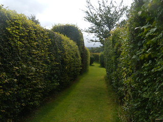
Manicured footpath
Not many footpaths have their own lawn and neatly clipped hedges Hassocks to Brighton
book3 swcwalks walk50 3875384458
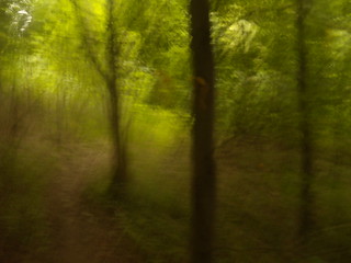


Gate out of a wood...
....into a lime green sea, Hassocks to Brighton
book3 swcwalks walk50 3874603541
| Length |
Main Walk, ending in Brighton: 22.5 km (14 miles). 5.5 to 6 hours walking time. For the whole excursion including meals and trains, allow 8 to 10 hours. Short Walk, ending in Falmer: 12 km (7.5 miles). 3 to 3.5 hrs walking time. |
|---|---|
| OS Maps | OS Explorer OL11, Landranger 198. |
| Toughness | 7 out of 10 (6 out of 10 for the Short Walk). |
| Features |
Different from walking the South Downs ridge, this route traverses north to south exploring hidden valleys, woods, open access and park land. The goal is the lively town of Brighton and the sea but first you will pass through the pretty village of Ditchling, walk over Ditchling Beacon, through Stanmer Park, passing Stanmer House (a lunch option) then through the University of Sussex campus to Falmer, the pub stop on the walk. There is a natural breaking off point at Falmer but those who persevere walking towards Brighton will be rewarded with a lovely view of the sea from Kemp Town Racecourse and an easy path into Brighton. The boardwalk, pier, seafront bars, Mediterranean cuisine, fish and chips or oysters and champagne and The Lanes (eclectic shops) await you:and of course,the possibility of a swim in season. |
| Shortening the Walk | You can shorten the walk by
|
| History |
Hassocks is a large village and civil parish in the Mid-Sussex District of West Sussex, situated just to the north of the South Downs, some 7 miles north of Brighton. The town's name is believed to be derived from the tufts of grass found in the surrounding fields. Starting life as a small hamlet, Hassocks grew in size after the advent of the London to Brighton railway in 1840. The town's population today is circa 8,500. Ditchling Village is a village in the Lewes District of East Sussex, close to the border with West Sussex. The village is now within the boundary of the South Downs National Park. St Margaret's Church was founded in the eleventh century. Its Nave dates from the church's beginning although its flint and sandstone walls date from the thirteenth century. Famous residents of Ditchling and its surrounding hamlets include the late Dame Vera Lynn and the late Sir Donald Sinden . The South Downs National Park is England's newest national park, being designated as such on 31 March 2010. The Park covers 628 sq miles in area and stretches for 140 km (87 miles) from Winchester in the west to Eastbourne in the east, through the counties of Hampshire, West Sussex and East Sussex. The terrain within the Park includes the chalk hills of the South Downs and a substantial part of the Western Weald with its wooded sandstone and clay hills. The South Downs Way spans the entire length of the Park and it is the only national trail that lies entirely within a national park. Stanmer is a small village on the eastern outskirts of Brighton, within the boundary of the unitary authority. The village still has a working farm at its centre. The village was a "closed village" from the sixteenth century until 1952, being owned by the Pelham family - see Stanmer House below. Stanmer House was built in 1722 for the first Earl of Chichester, Thomas Pelham by the architect Nicholas Dubois. Set in 5,000 acres of parkland. the house incorporates an earlier house from 1594 part of the estate of the previous owners, the Michelborne family, who were connected with the manor then called Audwick. The new house is built in the Palladium style popular for English country houses, with little adornment. A later extension to the right wing may be said to have spoiled the symmetry. Nevertheless, the hosue is Grade 1 listed. Brighton Corporation (now the Unitary Authority of Brighton and Hove) purchased the Stanmer Estate from the Pelham family in 1947. In 2017 the council secured lottery funding to restore the walled garden as part of the Stanmer House Restoration Project, now completed. Until March 2020 the property was leased by a company who operated a restaurant in the property which was also a popular wedding centre. The company went into administration shortly after Covid lockdown but good news, a new company took over the house and reopened it in 2022 as a wedding centre, garden cafe and restaurant. Stanmer Church was built in 1838 on the site of a fourteenth century predecessor, demolished by the 3rd Earl of Chichester. The current, Grade 11 listed church has an unusual narrow spire. The church was declared redundant in 2008 and deconsectrated. Today the church is looked after by the Stanmer Preservation Society, who open the church for visitors on Sundays. The University of Sussex occupies the eastern section of Stanmer Park. The university received its Royal Charter in 1961, since when it has continued to grow in size to this day. From its onset the university was clasified as a "Public Research University" and more than a third of its current student population of 20,000 are post graduates. Brighton is a seaside resort, a unitary authority geographically located in the county of East Sussex, on the south coast some 47 miles south of London. Brighton became a fashionable resort in the Georgian era, encouraged by the patronage of the Prince Regent - later King George 1V - who constructed the Royal Pavilion, an iconic Regency palace and museum located in the centre of the town. Following the arrival of the railway in 1841 Brighton became popular with day trippers from London, which remains to this day. In the Victorian era the grand hotels on the seafront were built, as were the two piers - The Palace Pier aka Brighton pier, and the West Pier which closed in 1975 and of which little remains. Brighton remains a popular destination for tourists, not just for the impressive seafront but for the character of the town, whose population of over 300,000 is made up of diverse communities. With its thriving cultural, music and arts scene - and quirky shops (The Lanes) - Brighton has for some time been the unofficial gay capital of the UK - with its annual gay Pride Parade, and Pride Festival, being a major event. Brighton's Elm Trees There are 17,000 elm trees in Brighton - and as Sir Michael Caine might say - "not many people know that ". In the 1970s and 1980s some 25 million elm trees in central and southern England succumbed to Dutch Elm disease. Brighton's elms, planted in the late Victorian and Edwardian eras survived, partly due to the trees tolerance of the thin chalk soil and salty sea winds. Conservators also imported Rock Elm trees from the USA to help boost their English cousins. Whilst the Great Storm of 15 October 1987 took out many trees, today there are many elms to admire in the town. |
| Transport |
Take the train nearest to 09-30 hrs from London Bridge to Hassocks. Currently (2021) there is also a twice an hour direct service (weekdays and weekends) from Victoria to Hassocks (Brighton service). For those concluding their walk at Falmer, the railway station is 750 metres from the Swan Inn; Falmer Station is on the south side of the A27 but can be accessed by pedestrians from both sides. Either through an underpass at the entrance to University of Sussex, or by footpath through the grounds of the Univ. of Brighton on the south side. Trains to Brighton run every 15 minutes on weekdays and every half hour on Sundays. Buses to Brighton : Bus 25 every 10 mins (15 mins Sun) from Falmer Village South (Univ of Brighton side) Trains from Brighton to London Run twice an hour to Victoria (Southern) and four times an hour to London Bridge (Thameslink), changing if necessary at Clapham Junction. Do not take the Gatwick Express service unless you have purchased a ticket for its use. Thameslink tickets are usually less expensive than Southern tickets. If driving, then there is a large car park at Hassocks Station. |
| Lunch |
For picnic provisions: by Hassocks Station is the Downsview Delicatessen (open from 6:30 everyday except Sunday). The cafe and deli in Ditchling Village appears to have closed. The suggested lunch stop on today's walk for the discerning walker who prefers to dine in comfort is Stanmer House (tel 01273 977667) which reopened in 2022 as a wedding centre, with restaurant and a garden cafe both fully open to the public. Walkers are made welcome. The House claims to offer the "Best Sunday roast and afternoon tea in Brighton". Sunday walkers can check out this claim for themselves !. Otherwise, the cafe and restaurant are open (as of Summer 2023) seven days a week, with a good varied menu for lunch or early tea. For walkers who prefer pub grub and good draught beer or draught German lager, in a pub without a hint of pretension, their suggested lunch stop - some 12 kms into the walk - is The Swan Inn at Falmer North (Tel: 01273 681 842), serving food from 12 noon to 2-30 pm weekdays, and until 4 pm on Sundays. Note: during the football season, when Brighton & Hove Albion are playing at home, in the nearby Amex stadium, the pub becomes more than busy all day, and is best avoided. The Stanmer Tea Rooms in Stanmer Village after 9.5 kms, with indoor and outdoor seating (some under cover), makes for a pleasant informal lunch stop for those who are happy with a light cafe menu of baked potatoes, panini, sandwiches, cakes and scones. In Falmer Village South is The Falmer Cafe open 9 am to 4 pm, serving cooked breakfasts, baked potatoes and sandwiches in an industrial barn, with inside and outside seating areas. There is the Park Farm Shop , open 9 am to 5 pm daily (until 12-30 pm on Sundays) just after Falmer Village South where you can purchase farm produce for a healthy, late picnic. |
| Tea |
Brighton offers a multitude of choices. The park in the middle of Old Steine makes a nice change from the beach for a picnic, but many people like the beach and the boadwalk along the seafront on the west side of the pier where you can have your fortune told, buy original paintings and eat candy floss and seafood. There are bars here some with live music. Most people make their way to The Lanes for an evening meal. N.B. Brighton and Hove Council has adopted an alcohol-free zone throughout the borough. The police exercise discretion, but in general anyone caught drinking in the streets will have the alcohol confiscated. A spokesman said that drinking would be allowed in open-air cafés spilling on to the streets, but otherwise officers would stop drinkers in parks, squares and streets. Not sure whether this applies to the beach. |
| Author | Original 'map led walk' © 2008 by AJ Kennedy. Expanded, and completely re-written in SWC format in May 2017. History added August 2020. This Book check and walk update September 2021. Lunch option update August 2023. |
| Profile | |
|---|---|
| Help Us! |
After the walk, please leave a comment, it really helps. Thanks! You can also upload photos to the SWC Group on Flickr (upload your photos) and videos to Youtube. This walk's tags are: |
| By Train |
Out (not a train station) Back (not a train station) |
| By Car |
Start BN6 8JD Map Directions Return to the start: Finish BN1 3XP Map Directions Travel to the start: |
| Amazon | |
| Help |
National Rail: 03457 48 49 50 • Traveline (bus times): 0871 200 22 33 (12p/min) • TFL (London) : 0343 222 1234 |
| Version |
Aug-23 Marcus |
| Copyright | © Saturday Walkers Club. All Rights Reserved. No commercial use. No copying. No derivatives. Free with attribution for one time non-commercial use only. www.walkingclub.org.uk/site/license.shtml |


Walk Directions
Hassocks to Falmer
- For a slightly shorter, more direct route to the South Downs, see the 'via Jack and Jill' option below.
- Exiting Hassocks Railway Station , proceed in an easterly direction down the slip road, passing the Hassocks pub on your left-hand side and then head down the High Street. You pass Hassocks Infants School on your left-hand side, then the United Reformed Chuch, and after 375 metres along the High Street turn left into Grand Avenue, a tree-lined residential road.
- Ignore ways off as the road swings steadily to the right and in 880 metres you come to a road T-junction, with the Thatched Inn pub on your right-hand side. Cross the road, go through a wooden kissing gate and take the path half-right across a field, in a south-easterly direction, following the footpath sign. In 260 metres go over planks either side of a wooden kissing gate in a field boundary and keep ahead on a fenced in path between fields, ignoring a path to your right, your direction 130°.
- In 190 metres go over slats then through a squeeze stile and go over a planks to continue ahead on a wide path between wire fences (muddy in winter), your direction east. In 700 metres exit the path over a stepped stile and turn right onto a minor tarmac road (Lodge Hill Lane), which soon bends to the left, then right, in 150 metres passing a pond on your left-hand side, to join a main road, with a war memorial on your right-hand side in a triangular grassy space.
- Turn left on this road (West Street) and walk through Ditchling Village , passsing St Margaret's Church on your left and above you (worth a visit) and the White Horse pub on your right. You may find the Ditchling Tea Rooms open for morning coffee or elevenses.
- At the crossroads, cross straight over and keep ahead, to pass on your right-hand side Ditchling Village Hall and Council offices (where there are public conveniences), then a Health Centre. 50 metres bneyond the centre [!] turn right down a drive, following a sign on your right on a brick wall "To the Downs".
- In 80 metres the drive swings to the left and you continue down between hedges. In 85 metres bear right to go through a gap in the hedge (stile missing) and bear slightly left over a field. In a further 70 metres, at the end of the field, go over planks and a stile and bear half-left across the next grassy field, your direction 150°. In 120 metres go over planks either side of a stepped stile, go through a squeeze stile and over more planks and go into the next grassy field. Keep ahead across this field, your direction 140°.
- In 165 metres, in the top left-hand corner of the field, go over a stile in a hedgerow and head along a rough path, with a post and rail fence on your right. In 50 metres go over a stile, and bear left to come out onto a track. Turn right on this track, now in woodland. In 40 metres another track joins from your right, and you keep ahead, your direction now 70°.
- In 55 metres at a path Y-junction, take the right-hand path with the edge of the wood on your right-hand side. Keep ahead, gently uphill, ignoring all ways off, as you head towards the South Downs. In 700 metres you come to a T-junction with Underhill Lane, a narrow tarmac road, with hedges on either side, where you turn left .
- In 60 metres turn right onto a signposted footpath, initially a gravel track, soon a chalky path with an uneven, tree root footbed. You follow this path steadily uphill, and just after you pass a sign for Ditchling Beacon Nature Reserve on your right-hand side, you take the left path at a path junction. The path soon becomes much steeper as you proceed uphill, through bends, on a path that in places is deeply rutted and challenging to find a safe footbed, but persevere and keep ahead. You now have fine views below on your left. Towards the top of your steep ascent you have a road below and parallel to you on your right-hand side. The path now begins to level out and at a four-armed footpath sign on your left-hand side, cross the road on your right, go up steps on your left-hand side and pass through a circular car park, following signs South Downs Way . In summer at weekends there is usually an ice cream van parked here, for refreshments after your steep climb up on to the Downs. At the far side of the car park pass through a wooden swing gate to the left of a wooden fieldgate by a National Trust sign for Ditchling Beacon .
- Keep ahead, now in the Ditchling Beacon Nature Reserve , gently uphill. In 125 metres you pass Ditchling Beacon Trig Station some 50 metres over to your left. Your path now starts to descend as you follow a fenceline on your left-hand side.
- In 120 metres [!], by a four-arm footpath post on your left-hand side turn left through a wooden swing gate marked Access land, to follow a fenceline on your right-hand side, your initial direction 200°. [The alternative Jack and Jill start from Hassocks joins here at this post] .
- Keep ahead over the brow of a hill on a grassy way, and you soon have views of the sea ahead of you. In 200 metres pass through a field boundary with a metal fieldgate at right-angles to your right (off its hinges September 2021) and keep ahead, now gently downhill, between fences. In 100 metres go through a metal swing gate to the right of a metal fieldgate, to follow a fenceline on your left, with vast open fields in a valley over to your right. In a further 150 metres go through a field boundary and keep ahead, now betweeen fences again, and head up and over the next brow.
- In 200 metres ignore a metal swing gate and footpath on your left and pass through a wooden swing gate (or go through the usually open metal fieldgate to its right), and head downhill, still between fences, on a car-wide track. In a further 170 metres at the bottom of the slope pass through a propped open metal fieldgate in a field boundary and swing left to follow a clear path which soon swings right to follow the contours of the next field, with a grassy valley down below to your right.
- In 550 metres at the top end of this field turn left through a wooden swing gate and follow the the edge of the next field, uphill. In 60 metres go through another wooden swing gate to cross Ditchling Road slightly to your left and by a two-armed footpath sign enter Highpark Wood . Keep ahead on the footpath (yellow arrow) and not the bridleway (blue arrow) to its left. In 45 metres at a multiple path crossing [!], ignore the metal kissing gate some 10 metres over to your right, pass between concrete posts and keep ahead on a path, downhill, keeping close to the edge of the wood, your direction 145°. In season you have a sea of bluebells over to your left. Head down this winding, undulating path.
- In 400 metres you come down to a wooden swing gate on your right-hand side. Go through and follow the fenceline on your left, downhill, and in 40 metres go through another wooden swing gate to head down through a woodland strip, with an open field over to your right. In a further 400 metres, at the end of the woodland to your left, go through a wooden swing gate (usually propped open) and follow a narrow, winding path through a strip of woodland between open fields.
- In 500 metres exit the wood through a wooden swing gate and turn left to follow a grassy way, gently downhill, towards Stanmer Village, with a post and wire fence on your left-hand side, along the left-hand edge of a large field which slopes uphill to your right. In 400 metres pass through a metal swing gate, 2 metres to the right of a metal fieldgate, and in 80 metres at a track T-junction, turn right .
- In 200 metres you pass barns on your right-hand side and in a further 30 metres go through a wooden swing gate to the right of a pair of wooden fieldgates into the Village of Stanmer . Walk through the Village, in 160 metres passing Stamner Tea Rooms on your left-hand side, an early lunch stop.
- A tourist bus number 78 runs from Stanmer Village to Brighton during the summer months and is an early opt out.
- After the Tea Rooms, continue due south down the road, in 20 metres passing Brighton Permaculture Trust centre on your right. You now pass a large barn on your left and in 60 metres you come to a fork in the road, with Stanmer Church directly ahead of you.
- You now have a choice of routes: the left fork (the exit road) allows you to enter sloping access land to your left at various points if you don't want to walk along the exit road towards the University campus. Note : there is an attractive path some 50 metrss to the right of the road, with a gravel base. The right (entrance) fork gives access to Stanmer House and allows you to walk along a pleasant grassy way to the right of the road towards the campus.
- If taking the right-hand fork, in 40 metres you pass the entrance to the church on your left-hand side (usually locked), and in a further 60 metres you turn left to pass in front of Stanmer House , under new management and reopened as a popular lunch option - restaurant and cafe - since 2022.
- Walk to the end of the green in front of the house and then follow the main treelined driveway on a grassy way some 20 metres to its right for 800 metres to the very end of the fencing on the left, at the end of the car parking bays either side of the road.
- You now have 2 choices
- A) Via Sussex University, Falmer Village and towards the pub
- Turn left through two low wooden posts to head uphill on a path, your direction 35°, following a fenceline on your left and with a sports field over to your right. In 175 metres the fence on your left ends at a cross paths and you keep ahead, half left, on a grassy way, uphill. In 90 metres at the top of the slope you enter a patch of woodland, go through and bear half right through some trees to head down towards University buildings, aiming for a prominent "No Entry " sign. Exit the woodland by dropping down a grassy bank past this sign and keep straight ahead, passing Silverstone block on your left, then Arts C block on your left and Arts B block on your right. Now on Arts Road, you pass under a bridge with a building over and you follow Exit signs, soon steadily uphill.
- Continue along this road which soon becomes steeper (Boiler House Hill) passing campus buildings to left and right. You pass the entrance to Falmer Sports Centre on your left and some 50 metres before you reach a slip road to the A27, turn left into Mill Street. A short distance down this road, turn right into Park Street. In 80 metres you come to the Swan pub on your left, your suggested lunch stop.
- Falmer Village to Falmer Station, the bus or Brighton : Coming out of the pub, turn left onto Middle Street. In 30 metres cross the A27 road on a footbridge and continue over to its far side (do not take the ramp down on your right to the bus bay). Turn right then left into Park Street, Falmer South, soon passing a pond on your left-hand side. If you wish you can turn left at the end of the footbridge to come out onto East Street then St Laurence Church (usually locked). The Falmer Cafe is a little further down the road, with the pond to your right. Otherwise, once past the pond, the road swings to the right and in 50 metres you pass The Park Farm Shop on your right, where you can purchase provisions for a late picnic.
- Cross over the crossroads and in 80 metres go past the main entrance to the Amex Stadium , home to Brighton and Hove Albion football club, on your right-hand side. In a further 125 metres, just before a mini-roundabout and the entrance to University of Brighton Falmer Campus , by a footpath sign, turn left over a stile onto a narrow path (overgrown in summer), your direction south, with a fence and field on your left and a woodland strip to your right. Note The short walk ends at the entrance to the University of Brighton entrance: those wishing to catch the train to Brighton can walk through the campus to find the pedestrian access to Falmer station, or catch the 25 bus to Brighton which leaves from here.
- B) Direct Route to Falmer Railway Station
- Instead of turning left through the two low wooden posts to head uphill etc, keep ahead on the driveway for a further 250 metres. At the end of the driveway, where it turns right in front of the A27 road, turn left along the broad pavement, walking parallel to the A27. In 80 metres, at the first junction in the path, bear right following the sign "Pedestrian route to the University". Keep ahead on this path and in some 200 metres at the next junction, turn right to go under the underpass, under the A27. A little beyond the far end of the underpass you have a flight of steps ahead - and slightly to the right - of you. Go up these steps and Falmer Railway Station is directly ahead of you. The nearside platform is for trains to Lewes. Cross over the footbridge for trains to Brighton.
The Long Walk Option (further 10 kms from Falmer to Brighton)
- Continue along the footpath heading south at the entrance to the University of Brighton campus. In 370 metres you come out into a field and turn right in a westerly direction to follow the right-hand edge of a large open field down into a dip and up the other side, with woodland to your right. In 450 metres at the end of the field do not go through the metal swing gate in the boundary ahead of you but instead turn left in a southerly direction once again, keeping the fence on your right.
- In 400 metres at the bottom of a dip at the end of the field ignore a faint path to your left and keep ahead , now steeply uphill, between blackberry bushes. In 100 metres a track joins from your left. In a further 120 metres, at the top of the slope, by a four-armed footpath post, turn right , once again heading west, on a public bridleway, an earth and grassy track, between fences.
- In 450 metres you come out into the open with a panoramic view of Brighton and the sea ahead of you. Pass through a new wooden swing gate some 2.5 metres to the left of a pair of wooden fieldgates and take the grassy path slightly to your left, steadily downhill, following the fenceline on your left. Ignore all ways off and numerous gates on your left as you descend to the village of Bevenden. Your target is the radio mast on top of the hill opposite.
- In 700 metres you pass through a wooden fieldgate and continue downhill as the path swings to the left, now an uneven chalky track. In a further 150 metres pass through a metal kissing gate to the right of a metal car blocking barrier (or climb over the low barrier) to exit onto a road in the village of Bevenden . Here turn right down the road and in 100 metres cross a pedestrian crossing and head up Auckland Drive. On your left is a recreation ground with school beyond.
- In 60 metres, with a School Passing sign on your right, turn right on a footpath, up a flight of steps. Head up this path, go up more steps and cross a concrete road to go up Fitch Drive ahead of you. In 50 metres you come to Dartmouth Crescent on your left-hand side. Go along this road and in 80 metres, at its cul-de-sac end, turn right up a footpath, due south, rising steeply uphill towards the radio mast and alongside rather scruffy horse paddocks.
- In 475 metres at the top of this path, cross the fork in the main road and then the road itself to enter onto Kemp Town Racecourse . Cross the racecourse through gates in fences either side and then cross over a cinder track to enter open access land, to the side of the racecourse. Turn right and follow the contours round, on a grassy way, in a south-westerly direction, keeping the racecourse on your right-hand side. You are now aiming for the big TV mast in the distance.
- In 850 metres cross a road to walk over rough ground towards the TV mast. Some 20 metres before you reach the mast, and with barriers marking the end of the racetrack on your right [!] turn right over rough ground and in 30 metres keep ahead. In 15 metres turn left through a wooden swing gate and take the path, downhill, passing the end of houses to your right. In a further 60 metres go down earth steps to a cross paths, with a cul-de-sac end to a road over to your right. Turn left at this path junction, and proceed down this woodland path, ignoring all ways off.
- In 500 metres the path comes down to join a tarmac drive, with a fenced and gated entrance to a school on your right-hand side. Continue down this drive and in 90 metres go past a gate to come out onto Walpole Road. Turn right and in 60 metres the road swings left to pass the gated entrance to Brighton College playing fields on your right.
- Head down to cross over Eastern Road, and head down College Place. At the junction with St Georges Road turn right along Bristol Road and come to Upper St James's Street. Proceed along this street which turns into St James's Street, with its multitude of cafes, bars and antique and curiosity shops. For your sea front fix now turn left down any street to Marine Parade.
- For Brighton's Cafes and Brighton Railway Station Head along Marine Parade. At a main road junction, with the entrance to Brighton Pier on your left, keep ahead, then cross the road and head down one of the minor streets on your right. Soon you are in Brighton's Lanes . To get to the railway station you need to head northwards to North Street, where you turn left , uphill, until you reach Queen's Road at the Clock Tower. Here turn right and walk up Queen's Road all the way until you reach Brighton Railway Station directly ahead of you.
Option : The slightly shorter Book 1 'Jack and Jill' start
- [1] Coming off platform 2 at Hassocks Railway Station, go down the station approach road. In 35 metres you pass The Hassocks pub on your left and take the tarmac path to your right , signposted South Downs, with a brick walk on your left.
- In 25 metres you come to the B2116 road and go right along its pavement towards the railway bridge but before you reach it, in 40 metres, cross over the road and by a bus stop go left on a footpath signed South Downs.
- An alternative, somewhat more straightforward route is to go past this footpath and after 5 metres turn left through brick pillars on an unmarked path that continues with the railway on your right for 250 metres till you rejoin the main route at [*].
- For the main route, go ahead on the first path, your direction 190°. Ignore ways off and in 150 metres you cross a tarmac road to go on, slightly to the right, following a footpath sign, your direction due south.
- In 100 metres you come to a T-junction with a three-armed footpath sign where you go left, your direction 205° with the railway embankment wall on your right. [*]
- In 10 metres ignore the tarmac path on your left and keep ahead, initially with garden fences on your left and the embankment wall on your right. In 200 metres a pleasant detour (unless muddy underfoot) is to go through a gate to your left into the Woodland Trust’s Butcher’s Wood (marked in the OS map) and then to keep on, in the same direction as your previous route. In 250 metres go through a kissing gate to rejoin the previous path. 25 metres after rejoining the route, ignore a squeeze stile and footpath to the left.
- In 175 metres go over a cross paths and ignore the path on the right which goes over the railway line.
- [2] After 225 metres you leave the wood and can see the Downs ahead with the Clayton Windmills to the left. In a further 400 metres you come to the A273 road where you go left. (There is an interesting turreted house to your right on the far side of the main road.) In 35 metres cross the B2112 road to Ditchling and go through the wooden kissing gate opposite, heading due south over a sports field towards the Church of St John the Baptist, Clayton (worth a visit). Turn left at the hedge and walk past the back of a building on your left for 5 metres to go through a gap in the hedge on your right on to a road, opposite the church.
- Go left on the tarmac road (or if you visit the church come out of the lychgate and turn right).
- In 120 metres, as the road swings left, turn right on a signposted bridleway through the entrance to Clayton Court Stables, your direction 185° on a wide track, steadily uphill towards the windmills, with a tree line on both sides.
- The path becomes steeper and after 150 metres go though a wooden swing gate to come out into the open. Here turn half-right and continue on the uphill path, due south. When you reach the top of the ridge continue ahead till you reach the nearest, white Jill Windmill Clayton. Its car park is on your right.
- Go past the wooden kissing gate giving access to the car park and then go through a wooden swing gate onto a signposted fenced-in path along the left-hand side of the windmill gardens, your direction 130°. Veer right with the path beyond the top, black Jack Windmill and cross over a farm track to an earth road T-junction by a two-armed sign post. Turn left, your direction 115° onto a wide bridleway, The South Downs Way .
- [3] In 120 metres take the left fork, your direction still 115°. In 15 metres go through a metal fieldgate and head steadily uphill, now on a chalky track.
- In 650 metres ignore a bridleway to the right, pass metal fieldgates on either side and stay on the South Downs Way, gently uphill. You now have extensive views both to the left and towards the sea over on your right. In 350 metres ignore the bridleway to your right (to Chattri Memorial) and keep ahead as the South Downs Way levels out. In 40 metres ignore a wooden swing gate to your left and in 20 metres you pass a four-armed sign in a field on the left, pointing onwards to Eastbourne; this is the Keymer Post which also points left to Keymer village. In 15 metres go through a wooden swing gate and continue straight on, as the ridge path now starts to go downhill, on a broad grassy way.
- In 250 metres go through another wooden swing gate to the left of a metal fieldgate and in 10 metres you pass a dew pond on your left (Burnt House Pond). You now have gorse bushes over to your left.
- In 250 metres you pass another dew pond, this time on your right. [4].
- In 325 metres go through a wooden swing gate to enter Ditchling Beacon Nature Reserve to continue ahead, now with a fenceline on your right as the ridge narrows. In a further 300 metres turn right through the wooden swing gate by a four-arm footpath post marked Access Land to join the Main Walk Directions .