Kemble Circular via Thames Head and Cirencester walk
Past the Thames Head and along a disused canal, then up through woods to the Severn/Thames watershed and back through the magnificent Cirencester Park and Town

Thames/Isis River: Lyd Well
SWC Walk 256 - Kemble Circular (via Thames Head and Cirencester)
Feb-23 • thomasgrabow on Flickr
swcwalks swcwalk256 banner 52694350971

Signpost marking start of the Thames Path
SWC Walk 256 - Kemble Circular (via Thames Head and Cirencester)
Feb-23 • thomasgrabow on Flickr
swcwalks swcwalk256 banner 52694351326

Skew Railway Bridge over Thames & Severn Canal (detail)
SWC Walk 256 - Kemble Circular (via Thames Head and Cirencester)
Feb-23 • thomasgrabow on Flickr
swcwalks swcwalk256 banner 52694842568

View from Queen Anne Monument to Cirencester Park House and Parish Church
SWC Walk 256 - Kemble Circular (via Thames Head and Cirencester)
Feb-23 • thomasgrabow on Flickr
swcwalks swcwalk256 banner 52694617999
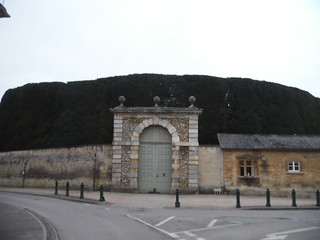
Wall around Cirencester Park and the tallest yew hedge in the world
SWC Walk 256 - Kemble Circular (via Thames Head and Cirencester)
Feb-23 • thomasgrabow on Flickr
swcwalks swcwalk256 banner 52694618399

Walk 256 Kemble circular- SWC Expeditionary Group
Aug-16 • peter.boon on Flickr
swcwalks swcwalk256 walkicon 28402208733
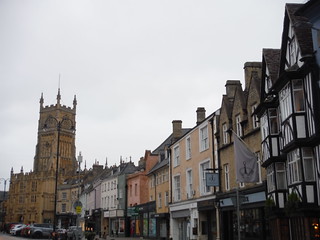
Market Place, Cirencester
SWC Walk 256 - Kemble Circular (via Thames Head and Cirencester)
Feb-23 • thomasgrabow on Flickr
swcwalks swcwalk256 walkicon 52694766150
| Length |
27.8 km (17.3 mi), with 208m ascent/descent. For a shorter or a longer walk, see below Walk Options. |
|---|---|
| Toughness |
5 out of 10, with 6 hours walking time. For the whole outing, including trains, sights and meals, allow at least 9 ½ hours. |
| Walk Notes |
This Gloucestershire walk at the southern edge of the Cotswolds AONB explores the springs and wells forming the source of the River Thames and a longer stretch of the upper river, as well as some of the woods of the large Bathurst Estate and Cirencester Park and Town, the ‘Capital of the Cotswolds’. After passing an assortment of springs and wells that constitute the start of the Thames and an Iron Age hillfort site right by the highest of the springs, you follow the disused Thames & Severn Canal to the Sapperton Canal Tunnel, before rising through Hailey Wood up to the watershed to the Severn Catchment Area and to Sapperton village, on the edge of the Golden Valley and with a splendid old church.
Three principle shorter versions are described and buses add additional options to cut bits of the route. Notes: The Upper Thames is a winterbourne river, only fed from aquifers and without tributaries in the area walked. In long dry periods it can be completely dry. Cirencester Park is open to the walking public daily 08.00-17.00 (sharp!), but may be closed on occasions. Check the estate’s website before doing this walk. |
| Walk Options |
Dogs are not allowed in most of the Bathurst Estate, including most of Cirencester Park and the permissive path by College Farm, so only a modified version of the Short Walk is possible. Several Bus Lines enable either shortcuts within the walk (to Cirencester, for example) or early finishes (from Cirencester or Ewen); the relevant bus stops are shown on the route map:
A Taxi from Cirencester to Kemble costs about £15.00 (01/2023 price). A Flood Diversion may be necessary at Trewsbury Mead by the Thames Head, as part of the route can be under water after prolonged wet weather, when the Upper Thames is in flow.
|
| Maps |
OS Landranger Map: 163 (Cheltenham & Cirencester)
|
| Travel |
Kemble Station, map reference ST 984 975, is 133 km west north west of London, 109m above sea level and in Gloucestershire. It is on the Swindon to Gloucester and Cheltenham Spa Golden Valley line, with an hourly service from Paddington. Journey times are 71 to 75 minutes. On Sundays a change is required at Swindon. Saturday Walkers’ Club: Take the train no later than 09.30 hours for the full walk. |
| Lunch |
The Thames Head Inn Tetbury Road, Kemble, Cirencester, Gloucestershire, GL7 6NZ (01285 770 259). Located 300m off route off the Trewsbury Mead Flood Diversion, very early into the walk. An Arkell’s of Swindon pub. A looped route off the flood diversion to the pub is shown on the route map. [The dangerous road walking can be avoided by following the flood diversion further along and reversing the loop from the pub where those routes meet.]
On the Medium and Short Walks, all Cirencester Tea Stops become Lunch Stops, from 13.1 km and 10.2 km into the walk respectively. |
| Tea |
Beano in the Park Cecily Hill,Cirencester Park, Cirencester, Gloucestershire, GL7 2EF (01285 653 135). The Beano is a hot drinks and snack Airstream located near the town entrance in Cirencester Park, 17.5 km (10.9 mi) into the main walk.
The Wild Duck Inn Drakes Island, Ewen, Cirencester, Gloucestershire, GL7 6BY. Located 3.0 km from the end of the walk. Currently closed for a major refurbishment.
|
| Thames Path |
This walk is part of the Thames Path [wikipedia] [National Trails] - a 184 mile national long distance path - that follows the Thames from its source in Kemble to the Thames Barrier at Charlton in SE London. There is an unofficial 10 mile south bank extension on to Crayford Ness. It follows the river's historic towpath where possible. In a few places, nearby paths are used instead as towpath sections do not match up where former "horse ferry" crossing have been lost. Through London, and on to the sea, there are north and south bank paths. |
|---|---|
| Profile | |
| Help Us! |
After the walk, please leave a comment, it really helps. Thanks! You can also upload photos to the SWC Group on Flickr (upload your photos) and videos to Youtube. This walk's tags are: |
| By Train |
Out (not a train station) Back (not a train station) |
| By Car |
Start GL7 6AW Map Directions |
| Amazon | |
| Help |
National Rail: 03457 48 49 50 • Traveline (bus times): 0871 200 22 33 (12p/min) • TFL (London) : 0343 222 1234 |
| Version | |
| Copyright | © Saturday Walkers Club. All Rights Reserved. No commercial use. No copying. No derivatives. Free with attribution for one time non-commercial use only. www.walkingclub.org.uk/site/license.shtml |

Walk Directions
Full directions for this walk are in a PDF file (link above) which you can print, or download on to a Kindle, tablet, or smartphone.
This is just the introduction. This walk's detailed directions are in a PDF available from wwww.walkingclub.org.uk