London Outer Orbital Path: Rainham to Purfleet via RSPB Rainham Marshes Walk
An easy birdwatching walk in Outer East London along an atmospheric section of the London LOOP via the RSPB reserve at Rainham marshes.


CIMG9947
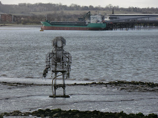
The Diver and Arklow Rambler
Feb-14 • Sean O'Neill
swcwalk172, swcwalks 5983339640613181346 P

| Length | 12.7 km (7.9 mi) with 5m ascent/descent. This does now include a circuit of the RSPB Reserve, as it does not require a ticket anymore.
For a shorter walk or a longer Alternative Ending or a longer Alternative Start, see below Walk Options. |
|---|---|
| Toughness | 0 out of 10, with 3 hours walking time. For the whole outing, including trains and meals, allow at least 5 hours. |
| Walk Notes |
This easy walk is completely flat, well signposted and on tarmac or other hard surfaces. Although the circuit of the RSPB Reserve is on boardwalks or hard surface tracks, some stretches can be muddy and/or waterlogged after prolonged wet weather. So, trainers or stout shoes are fine for this walk only after dry and average wet weather. It is not a countryside walk and the scenery even has some industrial units dotted about, and is best done in autumn or winter. The route to the reserve is evocative and atmospheric with fine views across the River Thames and the marshes. There are good bird-watching opportunities along the path by the Thames particularly if the tide is in.
The RSPB Reserve at Rainham Marshes has an excellent visitor centre, with a café, shop and toilet facilities and superb “picture window” views across the marshes and the Thames. As well as a wide diversity of bird life, the reserve has one of the highest densities of water voles in the UK. All in, if you can’t face any more muddy autumn or winter walks then this is a pleasant alternative and even if you are not a bird watcher it is an interesting and worthwhile day out. [But be aware that some of the paths within the RSPB Reserve can be muddy or waterlogged after prolonged wet weather.] Resident of the London Boroughs of Havering or Thurrock and members of the RSPB have always had free entry, but as of Q1/24 entry to the reserve is free for other walkers as well, while a car park charge has been introduced to contribute to the costs. |
| Walk Options |
For a RSPB Reserve-only walk, stay on the train to Purfleet and reverse-walk the route for 1.0 km to the Visitor Centre (turn right along London Road and in 450m, just before the Royal Hotel, turn left on the signposted riverside path until you reach the reserve in 600m).
|
| Maps | OS Landranger: 177 (East London)
|
| Travel |
Rainham and Purfleet stations are stops on the Grays branch of the Fenchurch Street to Shoeburyness line. Journey time to Rainham is from 23 minutes. Trains usually stop at Limehouse (DLR), West Ham (Underground) and Barking (Underground and Overground). Rainham station is in London Travel Zone 6 and Purfleet is one stop beyond this. Saturday Walkers’ Club: Take a train no later than 11.00 hours to arrive at the Reserve for lunch. There is an NCP car park at Rainham station with over 200 spaces, and also limited car parking at Purfleet Station. |
| Notes | The RSPB Reserve's published closing times are: 16.00 (1 November to 31 March) or 17.00 (1 April to 31 October). In practice they may close earlier though, so always confirm with staff before venturing out from the visitor centre. The car park will also be locked at the same time.
Café and bird hides are being closed from about an hour before closing time, starting with the hides furthest from the visitor centre. Should you find yourself locked in the Reserve, there is a One-Way Turnstile Exit near its south westerly corner, leading back onto the riverside cycleway. On the route map this is identifiable as the start of the Alternative Finish back to Rainham. The westerly part of the loop through the Reserve has most of the remaining military paraphernalia (gun emplacement, shooting butts, rifle range hut, target pools, the 'mantlet') as well as three bird hides. The easterly part has two bird hides and the former Cordite Store. |
| Lunch and Tea |
Rainham Marshes Visitor Centre Café. RSPB Rainham Marshes, New Tank Hill Rd, Purfleet, Essex, RM19 1SZ (01708 899 840). The café is located 1.0 km from the end of the walk. Simple warm food offered until 14.30, then just cakes and snacks. Café closed from the start of 2025 due to a nationwide re-focus on core activities by the RSPB.
Rainham Ending
|
| Profile | |
|---|---|
| Help Us! |
After the walk, please leave a comment, it really helps. Thanks! You can also upload photos to the SWC Group on Flickr (upload your photos) and videos to Youtube. This walk's tags are: |
| By Train |
Out (not a train station) Back (not a train station) |
| By Car |
Start Map Directions Return to the start: Finish Map Directions Travel to the start: |
| Amazon | |
| Help |
National Rail: 03457 48 49 50 • Traveline (bus times): 0871 200 22 33 (12p/min) • TFL (London) : 0343 222 1234 |
| Version | |
| Copyright | © Saturday Walkers Club. All Rights Reserved. No commercial use. No copying. No derivatives. Free with attribution for one time non-commercial use only. www.walkingclub.org.uk/site/license.shtml |

Walk Directions
Directions last checked: 17/01/2024
- This is a simple and well signposted walk following parts of Section 24 of the London LOOP and of the National Cycle Network, NCN Route 13
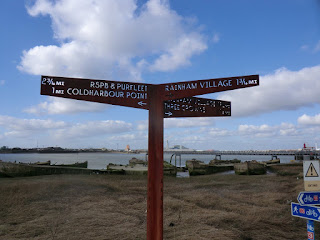
- On leaving Rainham Station, turn right on Ferry Lane to cross the railway tracks at a level crossing and turn second right to go up some steps to a bridge across the HS1 tracks, and then down the long ramped access leading to a tarmac path. Continue on this path with a three-way signpost ('RPSB & Purfleet 3 1/2 mi') with Rainham Marshes on your left, Ferry Lane to your right and the noisy A13 on a road bridge ahead. The still active Rainham Landfill (a future Country Park) is dominant on the left ahead and the Dartford Bridge is visible on the far left.
- On reaching the A13, use the well signed pedestrian crossings to navigate the roundabout under the raised road to rejoin a tarmac path by a three-armed signpost ('RPSB & Purfleet 3 mi'). You turn left across a bridge over a ditch and reach an info panel on the right about 'The Musketry Camps'.
Here you have a choice:
Option 1: Main Route along a narrow path early to the River Thames
- Turn right on a narrow grass then deteriorating tarmac path to the left of a wooden fence with a sign for “RSPB and Purfleet 4 mi and Three Crowns 1/2 mi”. This path may be a little overgrown in places and it runs parallel to Ferry Lane just away to your right. In 160m cross a car wide grass track and in 110m you pass a two-way footpath sign on your left. Continue on the path as it curves to the left with the road still just away to the right. In 470m cross a concrete bridge to reach a two-armed footpath sign and a road.
- Cross the road to continue in the direction of the footpath sign to go along a rough gravel path ('The Crown Walkway' as per a panel on the left) with a large industrial unit on your left. In 100m cross another road and continue up a concrete slab path bearing up to your left. In 90m, at the top of the short slope, the River Thames is away to your right, out of sight behind the sea wall. The 'Pilgrim Ferry' from Erith to Rainham landed here (1199-1854), originally connecting Lesnes Abbey across the Thames to the church in Rainham (see the plaque on the sea wall).
- Continue along the riverside path to go towards some large cylindrical silos 400m ahead. At these silos (the London base of Tilda Rice), bear right to cross a bridge continuing as an elevated walkway. There are fine views of the Thames to your right and across to Erith. You pass a large jetty on your right and the path narrows to a rough gravel track. After 100m from the end of the walkway, the path widens and continues on tarmac. In 75m you pass the first of many humorous wooden signs and crosses along the coming stretch.
- In 150m a tarmac path joins from the left from a car park. This is the Alternative Route. Re-join the text below.
Option 2: Alternative Route along a wide tarmac cyclepath through Rainham Marshes
- Take the signposted tarmac cycle path ahead (SE) through the reed beds and marshes and follow this meandering route, crossing several bridges, for 1.3 km until you reach a road. Cross the road and turn left. In 50 metres turn right on a wide tarmac path. Continue on this for about 400 metres to where it bears left to go up to a car park. The Thames is now in view to your right. You go through the car park and then bear right with the path to meet the Thames-side path ahead of you. This is the Main Route. Turn left along the path.
Both Options continue.
- There are several of the Concrete Barges on the right and you'll find a good info panel on them, the rice mill and the MUREX works that formerly stood here, away to the left along the tarmac path from a car park. In 80m you turn left with the path around an inlet and in 50m are level with The Diver, the statue mentioned above. The fenced Rainham Landfill site is on your left and you will follow its boundary almost to the RSPB Reserve in Purfleet.
- In 530m you pass an info panel on the left on 'The Port of London' and the landfill site. In 330m you cross the causeway of the jetty for the landfill site and in another 330m pass an info panel on the 'Changing Land' on the right, just before a left turn at Coldharbour Point with its beacon used by ships navigating the Thames.
- Continue along the tarmac path, now with the recently demolished Freightmasters Estate on your left (now replaced by three very large warehouses). Dartford Bridge is visible ahead. In 400m you pass an audio point on the Veolia Rainham Integrated Waste Management Facility (turn the handle to hear the audio; there are at least five different stories to hear).
- In 65m you have a road to the left behind a fence, this is the end of Coldharbour Lane, crossed much earlier, and the access road to the landfill site. On the right across the river, a very large concrete structure is rising high above the marshes, this is a flood barrier on the River Darent. In 700m there is a gap in the fence leading to a zebra crossing across the road and a path up the unfenced grassy slope of the landfill for panoramic views. In another 170m you reach Aveley Bay and turn left with the path.
- In 150m you pass an info panel on 'The First Sea Walls' and the diversion of Wennington Creek, just before a small car-park. Turn right in the car park to follow a rough but fine path atop the sea wall, with fine views of both the river to your right and the marshes to your left. Alternatively, there are the wide tarmac cyclepath down to the left, and a grass and gravel path below to the right.
- Continue on the raised path with the RSPB Visitor Centre visible ahead of you. In 320m all three paths go through gaps in a fence and in 400m (on the sea wall path) you go through a double metal gate and in 30m join the cyclepath. In 200m the path forks, with the tarmac cyclepath to the left and a rising gravel path ahead. In 25m (on the raised path) you go through a double metal gate and in 220m through another one. In 130m you join the cyclepath, just before the RSPB Reserve Visitor Centre's entrance.
- On leaving the visitor centre, turn left on the path and in 20m fork right with the NCN 13 ('Purfleet 1/4 mi'). In 20m you pass an info panel on 'An Ancient Forest' (6,000 years old tree trunks are preserved here in the river mud). In 20m cross a bridge over the River Mardyke and turn right with the path along the river.
- In 200m you pass the Purfleet Heritage Museum in the one remaining 18th century gunpowder magazine (1 of originally 5) and then loop with the path through the small Purfleet Heritage Park. After 200m fork left with the London LOOP to the right of The Royal Hotel to London Road in 80m. Turn right along the road and in 450 metres you reach Purfleet Station on your left. London bound trains depart from the near platform.
Alternative Ending back in Rainham
- From the One-Way Turnstile Exit, follow a clear path for 60m to a T-junction with the wide tarmac cyclepath and turn right with a two-way signpost along it ('Rainham Village 3 mi'). In 600m, at a three-way signpost, continue in the same direction ('Rainham Village 2 3/4 mi').
- You rise gently with the path, to the right of the landfill and its private access road, and to the left of Wennington Marsh. By an info panel on the right ('Muck and Money go together'), you are on a grassy shelf. This is the product of the Cunis Landfill, which long preceded the existing Veolia site. If you turn right to the edge of the shelf, this offers a grand viewpoint over the grazing marshes below and the RSPB Reserve away back to the right.
- At a crossing, turn left across Coldharbour Lane and turn right on the far side, passing the entrance to the Rainham Silt Lagoons opposite and an info panel on the left ('An Unnatural Landscape').
- You pass the car entrance barriers to the landfill access road and go under the silt pipeline. By the Riverside Car Park, at a three-way signposted T-junction with a tarmac track, turn right and go under a height barrier to Coldharbour Lane and turn left along it. In 50m turn right across the road and continue across a bridge and along a wide tarmac cycleway.
- You immediately pass another info panel on the left ('Farming the Marshes') and in 480m cross another bridge and turn left with the path. Cross one more bridge and after 700m you meet the outbound route by the roundabout by the raised A13.
- Retrace the route back to Rainham Station. You find The Phoenix pub about 100m beyond the station entrance.