Thames Path : Reading to Henley walk
A pretty stretch of the Thames towpath
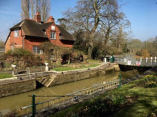
Sonning Lock
Reading to Henley walk
Mar-16 • Saturdaywalker on Flickr
walkicon swcwalks swcwalk61 25946810346
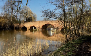
Sonning Bridge
Reading to Henley walk
Mar-16 • Saturdaywalker on Flickr
walkicon swcwalks swcwalk61 25877773391
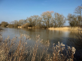
Afternoon view
Reading to Henley walk
Mar-16 • Saturdaywalker on Flickr
walkicon swcwalks swcwalk61 25946824386

Shiplake Lock
Reading to Henley walk
Mar-16 • Saturdaywalker on Flickr
walkicon swcwalks swcwalk61 25851954942

Marsh Lock, Henley
Reading to Henley walk
Mar-16 • Saturdaywalker on Flickr
walkicon swcwalks swcwalk61 25972750285

Tiger Moth
on the Thames at Kings Meadow
Nov-14 • magyardave2002 on Flickr
thames boat narrow book3 swcwalks walk61 15294224064

Up the river...to Oxford or...
over the bridge...to... Bristol?
Nov-14 • magyardave2002 on Flickr
sculpture thames book3 swcwalks walk61 15294230804
| Length | Reading to Henley: 16.9km (10.5 miles) Reading to Shiplake: 13.2km (8.2 miles) Shortcut to Shiplake: saves 1.7km (1.1 miles) |
|---|---|
| OS Map | Landranger 175, Explorer 171 |
| Toughness | 1 out of 10: entirely flat |
| Features | This is a simple walk along a pleasant section of the River Thames. You are on the riverside within 300 metres of leaving Reading station, and the way from there to lunch in the attractive village of Sonning is at first via waterside parks and walkways, and then through a wilder wooded section. After lunch you follow an unspoilt section of riverside between pasture fields to Shiplake Lock, and carry on around a pleasant loop of the river on a newly-opened section of the Thames Path to Shiplake village and station. After a section through suburban Shiplake, the walk returns to river's edge for the last section across a meadow to the dramatic weirs of Marsh Lock, and through a riverside park into Henley. The path presents no technical difficulties, and for most of the year the paths will be dry underfoot. Even in winter the paths are firm for most of the way to Sonning, the exception being some grassy parkland mid morning which can sometimes be a bit soggy. After Sonning the path can be covered with slippery mud, but is never boggy. The one exception is when very heavy rains cause the river to flood. There is one section about a kilometre before Shiplake Lock which is particularly prone to this: a lake forms on a field which then drains back into the river. This can produce about 100 metres of riverside path covered with up to thirty centimetres depth of water. Unfortunately, if you have got this far there is no alternative but to wade through it (as the author has done twice...) or to reverse the entire walk. As of January 2023 part of the broadwalk over Marsh Lock on the approach to Henley is still closed. This was shut in May 2022 due to supposed structural defects, with repairs supposed to be finished by November 2022. In January 2023 there was no sign of work having even started, but a bypass route for the Thames Path, running just west of the lock and adding about 400 metres to the walk length, is in place on permissive paths. It is described in the walk directions. |
| Walk options | It is possible to end the walk at Shiplake, as the walk passes the station there. This cuts 3.7km (2.3 miles) off the walk, making a walk of 13.2km (8.2 miles), but you will miss a beautiful approach along the river to Henley, not to mention its excellent tea stops. You can also do a shortcut to Shiplake, cutting out the last loop of the river before the village. This was the original route of this walk before a new section of Thames Path was opened. It saves 1.7km (1.1 miles), reducing the Reading to Henley walk to 15.2km (9.4 miles) and Reading to Shiplake to 11.5km (7.1 miles). |
| Transport | Trains to Reading from Paddington are fast and numerous, the fastest being the non-stop Great Western express trains which can take as little as 23 minutes. Get a train that arrives at Reading between 10.30 and 11.00. Buy a day return to Henley-on-Thames valid via Reading (rather than the slightly cheaper return which is not valid via Reading). You can use a ticket starting from a London Transport zone boundary on these non-stop trains, despite what the occasional misinformed ticket inspector on these trains says.
Holders of London Transport Freedom Passes (though not 60+ Oyster Card holders) can travel to Reading for free, so long as they travel on TFL trains (destined in due course to be Crossrail/Elizabeth Line services), but these are stopping services taking 56 minutes from Paddington. In this case you only need to buy a single ticket from Henley to Twyford on the return journey. Contactless, though not Oyster beyond West Drayton, can be used on these services. Trains back from Henley are every half hour (hourly after 7pm on Sundays), changing at Twyford. |
| Lunch | The Bull (0118 969 3901) in the pretty village of Sonning, 5.5km (3.4 miles) into the walk, gets popular at lunchtimes gets popular at lunchtimes, especially at weekends, so it is as well to get there early. However it does have a good number of outside tables too, both around its car park and in a well-hidden garden around its back. It serves food from 12pm to 3pm and from 6pm to 9pm Monday to Friday, and all afternoon at weekends, and is open for drinks all afternoon daily.
An alternative, next to Sonning Bridge, is the Coppa Club (0118 207 8971), which despite its name describes itself as "an all-day restaurant and social hub where everyone is welcome". I have not tried this establishment, but it seems to serve pub-like food in a modern pub-like environment, and has a beautiful garden on the river's edge. It is open all day and evening daily. |
| Tea | The Baskerville Arms by Shiplake station, 11.5km (7.1 miles) into the walk, is a possible early tea stop. In Henley best option is The Chocolate Cafe on the riverside near the town bridge, open till 5pm Monday to Friday and 6pm weekends. Another possible tea stop is the Henley Rowing Museum on the left in the riverside gardens as you approach Henley. Its cafe, open 10am to 5pm, is accessible without paying to go into the museum. Further along in the gardens on the left there is a tea kiosk. The centre of Henley (go to the town bridge and turn left) also has other tea options, and many pubs, the most obvious of which is The Angel on the Bridge by the bridge. |
| Thames Path |
This walk is part of the Thames Path [wikipedia] [National Trails] - a 184 mile national long distance path - that follows the Thames from its source in Kemble to the Thames Barrier at Charlton in SE London. There is an unofficial 10 mile south bank extension on to Crayford Ness. It follows the river's historic towpath where possible. In a few places, nearby paths are used instead as towpath sections do not match up where former "horse ferry" crossing have been lost. Through London, and on to the sea, there are north and south bank paths. |
|---|---|
| River Levels |
Shiplake Sonning Reading to Sonning |
| Profile | |
| Help Us! |
After the walk, please leave a comment, it really helps. Thanks! You can also upload photos to the SWC Group on Flickr (upload your photos) and videos to Youtube. This walk's tags are: |
| By Train |
Out (not a train station) Back (not a train station) |
| By Car |
Start RG1 1LZ Map Directions Return to the start: Finish RG9 1AY Map Directions Travel to the start: |
| Amazon | |
| Help |
National Rail: 03457 48 49 50 • Traveline (bus times): 0871 200 22 33 (12p/min) • TFL (London) : 0343 222 1234 |
| Version |
Jan-23 Peter |
| Copyright | © Saturday Walkers Club. All Rights Reserved. No commercial use. No copying. No derivatives. Free with attribution for one time non-commercial use only. www.walkingclub.org.uk/site/license.shtml |

Walk Directions
Full directions for this walk are in a PDF file (link above) which you can print, or download on to a Kindle, tablet, or smartphone.
This is just the introduction. This walk's detailed directions are in a PDF available from wwww.walkingclub.org.uk