Seaford to Eastbourne (The 7 Sisters) walk
The best walk in the Southeast! A dramatic cliff walk passing Cuckemere Haven, the Seven Sisters and Beachy Head as the South Downs meets the sea. Ends with Eastbourne's promenade and pier.

Book 2, Walk 28, Seaford to Eastbourne
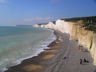
Seven Sisters, 28 March 2005
book2 walk28 walkicon swcwalks tocw228 347753820
Book 2, Walk 28, Seaford to Eastbourne
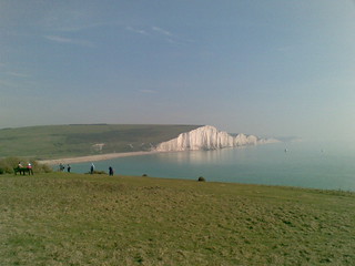
The Seven Sisters from Birling Gap, 23 Sept 2006
sevensisters birlinggap book2 walk28 230906 walkicon swcwalks tocw228 279347521
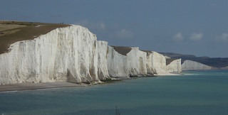
The Seven Sisters, South Downs
Between Eastbourne and Seaford on the South Coast, the Seven Sisters are even more dramatic than the White Cliffs of Dover.
Apr-07 • Paul Stephenson on Flickr
england haven walking sevensisters southdowns book2 cuckmere walk28 walkicon swcwalks 1570171119

Flagstaff Point and Belle Tout
Seaford to Eastbourne walk
Jul-16 • Saturdaywalker on Flickr
swcwalks book2 walk28 walkicon 28251684106


Seven Sisters from Seaford Head
Aug-16 • Saturdaywalker on Flickr
swcwalks book 2 walk28 walkicon 28788815913
The Seven Sisters and Beachy Head
| Length | Main walk: 21.9km (13.6 miles) Shorter options: Seaford to Exceat 6.2km (3.9 miles), Seaford to Birling Gap: 12.7km (7.9 miles), Seaford to East Dean: 15km (9.3 miles), Exceat to Beachy Head 10.4km (6.4 miles), Exceat to Eastbourne: 15.7km (9.7 miles), |
|---|---|
| Maps | OS Landranger Map 199 (a small bit of start on 198) OS Explorer Map OL25 (formerly 123) |
| Toughness | 9 out of 10 |
| Features | This classic cliff-top walk – one of the finest coastal walks in England – affords stunning (and very famous) views of the white cliffs of the Seven Sisters, and the renowned Beachy Head, before ending in the elegant seafront town of Eastbourne. There is quite a lot of climbing and descending on the walk – indeed, apart from the section around Cuckmere Haven and the finish along the Eastbourne seafront, almost none of the route is flat – but somehow in the grandeur of the scenery the effort is not noticed. In summer, the walk also offers numerous opportunities for a dip in the sea: see Sea Swimming below. Take care near the cliff edges on this walk, as they are crumbly and liable to collapse: the official advice is to keep 5 metres from any cliff edge. People taking selfies regularly ignore this advice: don't imitate them. |
| Walk Options |
This walk is well served by Brighton city buses, which enable you to start or stop the walk at various points. The number 12, 12a or 12x bus runs from Seaford via Exceat and East Dean to Eastbourne, with as many as six buses an hour Mondays to Saturdays, and three to four times an hour on Sundays. On all days of the week the service is half-hourly from about 8pm to 11pm. There is also a 13X, which operates the same route, but also taking in Birling Gap and Beachy Head. It runs three times a day on Sundays year round, while in the summer months it is hourly at the weekend and three times a day on weekdays. For more information and live departures on either bus, see www.buses.co.uk. To catch either bus in Seaford, turn right out of the station and stay on the main road: the stop is 200 metres along on the left. In Eastbourne the bus stops just off the main shopping street near the railway station. Using these buses, you could do the following shorter versions of the walk: a) Seaford to Exceat: A 6.2km (3.9 mile) walk with beautiful views of the Seven Sisters, which can be combined with a swim and a picnic at Cuckmere Haven. b) Seaford to Birling Gap: A 12.7km (7.9 mile) walk over the Seven Sisters, with lunch at Exceat and tea at Birling Gap: You can finish here when the 13X bus is operating, or see option c) below. c) Seaford to East Dean: In the walk directions a 2.3km (1.4 mile) link walk inland from Birling Gap to East Dean is provided which gives you access to the very regular number 12 bus service to Eastbourne or Seaford. Adding this to option b) above makes a total walk of 15km (9.3 miles). d) Exceat to Beachy Head. A 10.4km (6.4 mile) walk along the finest stretch of the cliffs: only possible when the 13X is operating: otherwise, you have to do option e) below. e) Exceat to Eastbourne: A 15.7km (9.7 mile) walk over the Seven Sisters and Beachy Head, with refreshment stops at Birling Gap and Beachy Head. It is also interesting to do this walk backwards: you get a steep climb out of Eastbourne to start, can have lunch at Beachy Head or Birling Gap, and then tea at the Saltmarsh tea rooms at the end of the Seven Sisters. The Eastbourne to East Dean walk on this website has directions for the first half of this walk. |
| Transport | Two trains an hour (one an hour on Sunday) go from London Victoria to Seaford, changing at Lewes (journey time 1 hour 25 minutes). Take the train nearest to 9.15 from Victoria to get to lunch at Exceat in time.
Returning from Eastbourne there are two direct trains hourly (one an hour on Sundays) back from Eastbourne to Victoria (journey time: 1 hour 30 minutes). By car : park at Seaford or Exceat, and catch the bus back there from Eastbourne. You could also park at Lewes, and catch trains to Seaford and back from Eastbourne. |
| Lunch | The Cuckmere Inn (01323 892247). Situated by Exceat bridge, 6.2km (3.9 miles) into the walk, this pub is very popular, but efficient at serving food from its wide menu. In summer, it has plenty of outside tables. It serves food all afternoon. Cafe Just Around the Corner (formerly the Saltmarsh Cafe). Situated in a charming open air courtyard next to the Seven Sisters visitor centre, 800 metres beyond the Golden Galleon, this tea room is open till 5pm daily in summer, but only till 4pm Thursdays to Sunday in winter. It serves hot meals as well as lighter lunch items such as sandwiches. Nearby, next to the Seven Sisters Visitor Centre, is the Grab and Go cafe, open till 4pm daily and serving hot drinks, sandwiches and light lunches. |
| Tea and dinner | The refurnished National Trust café at Birling Gap. 12.7km (7.9 miles) into the walk has a wonderful clifftop location, and is open to 5pm in summer, 4pm in winter. The Beachy Head pub (01323 728060), 16.6km (10.3 miles) into the walk, has the same menu and efficient service as the Cuckmere Inn (see Lunch). It serves tea, coffee, pudding and meals all afternoon and evening (till 10.30pm Monday to Saturday and 9.30pm on Sunday). It has plenty of tables overlooking the fine view backwards, so you can enjoy the walk you have just done. If you are stopping for dinner, note that it is 2km (1.2 miles) from this pub to the edge of Eastbourne, and another 3.4km (2.1 miles) from there to the station. Qualisea Fish Restaurant There are several places to have fish and chips in Terminus Road, the road leading away from the seafront in Eastbourne, but this one, 200 metres up the street on the right, is the traditional favourite. It has the usual takeway, but also a large restaurant. It is open till 8pm year round, sometimes later in summer. |
| Sea swimming | From mid June to September there are excellent opportunities for sea swimming on this walk, though as always you do so at your own risk. All the beaches are shingle, except for some parts of Eastbourne beach which can be sandy at low tide. Seaford has a relatively gently shelving beach that is swimmable at all states of the tide and sometimes has a lifeguard, but note that you get out of your depth very quickly. When large waves are slapping onto the shingle, this beach can be dangerous. A more scenic (and often more sheltered) spot for a dip is Cuckmere Haven, one of the few places on the South Coast where it really feels like you are wild swimming, with the white cliffs of the Seven Sisters making a wonderful backdrop. The only thing to watch out for is the current from the Cuckmere River, where it joins the sea. Traditionally this has flowed straight out from the river mouth, but some years storms or currents create a shingle bar which diverts it to the left or right. So have a good look to see what the latest position is. For three hours either side of low tide the sea retreats across a large area of rock and seaweed and it is very tricky to wade out far enough to get sufficient depth, at least on the west side of the beach; on the east side there is a sandy area that comes relatively close to the shore at one point, making wading out at low tide easier. Birling Gap is also a very scenic spot for a swim and is a popular beach in summer. Again the best time for swimming is two or three hours either side of high tide: outside this period the sea retreats across jagged rocks (the remains of eroded cliffs). The most awkward time is when these rocks are covered by shallow water: however, at very low tide you can sometimes pick your way through the rocks to the sea beyond, the area immediately opposite the steps being particularly rock-free. As at Seaford, larger waves can slap quite sharply down onto the shingle here, making getting in and out of the sea awkward or even dangerous. Eastbourne has a long beach and a seasonal lifeguard service on the section between the Wish Tower (the round Martello Tower) and the pier. This is a classic South Coast beach, with the sea coming up the shingle bar at high tide but retreating across sandy mud at low tide. South of the Wish Tower, low tide reveals an area of rock pools, making swimming tricky here at such times, but the main beach between the Wish Tower and pier can be swum at any state of the tide. |
| History | The Martello Tower in Seaford is the most westerly of a chain of 103 such fortresses (the other end of the chain being in Aldeburgh, Suffolk) built to protect the South East coast of England against invasion in the early part of the Napoleonic Wars. It contains a museum of local history, open 11am to 1pm and 2.30pm to 4.30pm on Sundays and bank holidays year round, and on Wednesday and Saturday afternoons in summer. The Seven Sisters is the name for the undulating cliffs between Cuckmere Haven and Birling Gap. They are thought to have been formed by glacier meltwater at the end of the last Ice Age: the meltwater carved steep sided valleys, which were then truncated by sea erosion into the cliffs we see today. The original Seven Sisters are the Pleiades, a group of seven stars which Greek mythology portrayed as sisters. There are in fact now only six Pleiades, one having exploded in antiquity, and from the approach to Cuckmere Haven there seem to be only six humps on the Seven Sisters too (the rise on which Belle Tout lighthouse stands, beyond the brown smudge of Birling Gap visible at this point does not count, as this is not part of the Seven Sisters). But there are in fact seven: one is hidden from view from this angle. Or are there eight? Careful attention to the walk text will reveal that between Cuckmere Haven and Birling Gap, you pass over eight hills in all – Haven Brow, Short Brow, Rough Brow, Brass Point, Flagstaff Point, Flat Hill, Baily’s Hill and Went Hill. So which one is not a real sister? Birling Gap, is a gap between the sisters (cliffs), now owned by The National Trust. There is a cafe (some outside tables overlook the sea), visitor center, toilets, and car park, with a metal staircase down the cliff edge to the shingle beach below. The rate of cliff erosion here is quite dramatic - as much as a metre a year. In the tea room there is a photograph of the bay 100 years ago which shows a row of nine coastguard cottages with a broad strip of grassy cliff top them and the sea. Now only a couple of cottages are left... and they are perilously close to the edge. Belle Tout is a former lighthouse that first entered service in 1828, over 130 years after the need for one was first suggested. It had 30 oil lamps, requiring two gallons of oil per hour. A problem with the lighthouse’s location soon became apparent, however – when the weather was bad, the clifftop tended to be shrouded in mist, so the light could not be seen. The cliff also blocked the view of the light from ships sailing too close to the shore. As a result, a new lighthouse was built – the one that still stands at the base of Beachy Head to this day. It opened in 1902, and Belle Tout went out of commission. It was a tea room for a while, accidentally damaged by Canadian artillery during World War II, and later restored by the local council. By the 1990s Belle Tout was a private house and in danger of falling into the sea due to cliff erosion, and so in March 1999 in a feat of engineering that captured national media attention, it was moved back 17 metres away from the cliff using hydraulic jacks. It was then bought by a preservation trust and in March 2010 started a new life as a luxury bed and breakfast, with the lattern room turned into a lounge with 360 degree views. |
| Tides |
27-Jul :
high: 03:55
low: 10:44
high: 16:25
low: 23:11
28-Jul :
high: 04:44
low: 11:34
high: 17:15
29-Jul :
low: 00:06
high: 05:40
low: 12:32
high: 18:14
30-Jul :
low: 01:13
high: 06:48
low: 13:44
high: 19:26
31-Jul :
low: 02:29
high: 08:16
low: 15:02
high: 20:51
01-Aug :
low: 03:42
high: 09:39
low: 16:10
high: 22:06
02-Aug :
low: 04:42
high: 10:43
low: 17:07
high: 23:02
Times for . Corrected for BST if appropriate. Contains ADMIRALTY® tidal data: © Crown Copyright and database right.
|
|---|---|
| Book |
This walk was originally published in Time Out Country Walks near London volume 2. We now recommend using this online version as the book is dated. |
| South Downs Way |
This walk is one of 9 stages of the South Downs Way - a 109 mile national long distance path - that traverses the South Downs National Park in South East England. |
| Profile | |
| Help Us! |
After the walk, please leave a comment, it really helps. Thanks! You can also upload photos to the SWC Group on Flickr (upload your photos) and videos to Youtube. This walk's tags are: |
| By Train |
Out (not a train station) Back (not a train station) |
| By Car |
Start BN25 2AR Map Directions Return to the start: Finish BN21 3QJ Map Directions Travel to the start: |
| Amazon | |
| Help |
National Rail: 03457 48 49 50 • Traveline (bus times): 0871 200 22 33 (12p/min) • TFL (London) : 0343 222 1234 |
| Version |
Apr-24 Peter |
| Copyright | © Saturday Walkers Club. All Rights Reserved. No commercial use. No copying. No derivatives. Free with attribution for one time non-commercial use only. www.walkingclub.org.uk/site/license.shtml |


Walk Directions
Full directions for this walk are in a PDF file (link above) which you can print, or download on to a Kindle, tablet, or smartphone.
This is just the introduction. This walk's detailed directions are in a PDF available from wwww.walkingclub.org.uk