Wanborough to Godalming Walk
Over the North Downs ridge to Watts Gallery, then a ramble to historic Godalming
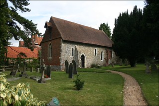
Wanborough church
This pretty church was built in the 1200s.
surrey book1 walk2 walkicon wanborough swcwalks 3897133643

River Wey
Wanborough to Godalming
Mar-16 • Cymbidium Clarisse on Flickr
wanborough godalming river wey swcwalks book1 walk2 countryside surrey walking path scenery scenic reflection walkicon 28353174022

Watts Gallery & Chapel
| Length |
12.87 km (8 miles), 3 hours 30 minutes. For the whole outing, including trains, sights and meals, allow at least 8 hours 40 minutes. In winter, it's best to be on your way from the Withies Inn by 2.30 pm, so as to reach the outskirts of Godalming before dark. |
|---|---|
| OS Maps |
Explorer 145 or Landranger 186. Wanborough Station, map reference SU 931 503, is in Surrey, 6km west of Guildford. |
| Toughness |
3 out of 10 |
| Features |
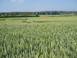
This short but lovely walk crosses open fields, passing Wanborough Manor and its tiny church. It soon goes over the Hog's Back (the North Downs ridge) to descend through a vineyard then over a golf course, to pass Watts Gallery, tea room, and Chapel. The Chapel (free) is worth the slight detour - author Aldous Huxley is buried in the Chapel grounds. A little further on is The Withies Inn, an excellent country pub. Later, after more woodland, the walk is along the River Wey, followed by tea, or a pint in the ancient town of Godalming. The original walk author was enchanted by this walk, above all, by Watts Gallery and Chapel, the monuments left by Mary Fraser-Tyler to honour her husband George Frederick Watts, a Victorian painter and sculptor, 'England's Michelangelo' ('though that's a bit rich,' a visitor was overheard to comment). Since then, the Gallery has had a Lottery makeover, and is no longer free. Its tea room has also been upgraded. The paths shortly after the start of the walk, and above the River Wey towards the end, are often waterlogged or very muddy in winter, so don appropriate footwear. On top of the Hog's Back, you have to cross the A31 dual carriageway, but there is a safe place to wait in the middle: you just have to be patient and wait for a break in the steady traffic. |
| Walk Options |
There is an hourly Guildford-Godalming bus service from Watts Gallery.The Watts Gallery staff may also be able to help you call a taxi, or you could take a taxi from the Withies Inn. For those wanting to walk long, on arriving in Godalming you can continue your walk alonside the River Wey on its tow path all the way to Guildford. This adds 4 miles to the walk. |
| History |
Wanborough ('bump-barrow') may be named after a Bronze Age burial site on the Hog's Back. A Wanborough manor and chapel are said to have belonged to King Harold's brothers and to have been ransacked by William the Conqueror's army marching up the Hog's Back. The present manor house was built in the eighteenth century. During the war it was a training centre for 'the members of the European Resistance Movement who served behind enemy lines in special operations, facing loneliness and unknown dangers in the cause of humanity'. Wanborough Church, one of the smallest in Surrey, was rebuilt by the Cistercian monks of Waverley Abbey in 1130, and was visited by pilgrims passing along the Pilgrim's Way. Railway bridge with crosses. Brian Beaumont-Nesbitt writes: "When Surrey C.C. wanted to build a by-pass through the Watts property, Mary Watts refused, then finally agreed - if the bridge was designed by Lutyens. It dates from 1931; the Vic Soc says it is 'an excellent example in miniature of Lutyens' interest in geometry. The tunnel surrounds, created with a sequence of stepped arches, are skilful exercises in perspectival adjustment - the vertical walls are battered, the centres of the arches are not the same, and the horizontal planes also taper." The original railings of oak cantilevered out had to be replaced by metal safety rails, but the two crosses over the Pilgrims Way have been renewed." Watts Gallery, Down Lane, Compton, tel: 01483 810235. Open Monday to Sunday between 10.30am and 4pm. Admission (2024): £13.50; £6.75 for Art Fund Members; £ 10.80 for English Heritage members. If you visit, look out for a vast sculpture of Watts' lifelong friend Tennyson (with his wolfhound), allegorical paintings of Time, Death and Judgement, political paintings of hunger and some coy nudes. Watts' most famous painting is the Rossetti-like portrait of the actress Ellen Terry, called 'Choosing' (would she give up the stage for him?). Their marriage, in 1864, is said never to have been consummated; he was 46 and she just 16. Watts Chapel was the project of his second wife, the artist and potter Mary Fraser Tytler, who designed this art nouveau masterpiece without previous architectural or building experience, inspired by the Home Arts and Industries Association, and with the help of local villagers. Every interior surface is covered with what Mrs Watts called 'glorified wallpaper' - angels and seraphs made out of gesso, a material which her husband used when rheumatism meant he could no longer handle wet clay. He is buried in the cloister behind the chapel. Admission is free, and it's open 9am (10am weekends) to 5pm daily. Godalming is thought to mean 'field (-ing) of Godhelm' (the putative first Saxon to claim the land). It was a coaching town between London and Portsmouth, and a centre of trade in wool, stone-quarrying, timber, leather, paper, corn and brewing. The High Street has many half-timbered and projecting buildings. On the north side of the churchyard of St Peter and St Paul in Godalming there is the Phillips Memorial Cloister designed by Thackeray Turner in 1913 with a garden by Gertrude Jekyll. Phillips was the chief wireless operator of the Titanic, who went down at his post on the ship. |
| Travel |
Take the train nearest to 10 am from Waterloo Station to Wanborough, changing at Guildford. Journey time around 50 minutes. There are three trains an hour from Godalming to Waterloo on weekdays and two an hour on Saturday and Sunday. Journey time 45 minutes. Buy a day return to Wanborough and on the return journey also buy a single from Godalming to Guildford. By car: There is free street parking near Wanborough station. Change at Guildford to return to your car. |
| Lunch |
For those who like a pub lunch, the suggested lunch stop is the Withies Inn (01483 421158) in the village of Compton, a 16th century freehouse, some 6.6 km into the walk. The pub's extensive garden is very pleasant for outdoor dining when the weather permits. Indoor dining times are as follows: lunch (2024) - Monday to Thursday 12 noon to 2 pm in restaurant, and until 2.30 pm in bar area. Friday and Saturday 12 noon until 2 pm in restaurant, and until 3 pm in bar area. Sunday 12 noon until 2.30 pm in restaurant, and until 3 pm in bar area. This is a very popular pub, and calling ahead to book is advisable on weekdays and is essential at weekends. The pleasant Watts Gallery Tea Shop (01483 811 030) is the alternative suggestion for lunch, some 4.7 km into the walk, open Monday to Sunday between 10-30am and 5pm, serving light meals and sandwiches. Their Welsh Rabbit and soups are recommended. |
| Tea |
The suggested tea stop in Godalming is the Cafe Mila (tel 01483 808569) in Angel Court, just off the High Street, which is open until 5pm Monday to Saturday and 4pm on Sunday. The ground floor is the family area and upstairs reserved for adults. Other tea options include the usual suspects such as Caffè Nero at 69 High Street and Costa Coffee at 74 High Street. Another good tea stop is Changing Perceptions Community Cafe and Workshop (tel 01483 420436) at 133A High Street. Open until 5pm Monday to Friday, to 4.30pm Saturday, closed Sundays. This community project offers training and employment opportunities for those with disabilities. Its cakes in the cafe section are reported to be delicious. For a pub, the best by far in Godalming for craft beer, real ale and cider is The Star (tel 01483 417717) on Church Street. Their burgers served from 5 pm are also excellent. Other pubs in town include The Red Lion on Mill Lane and the Wetherspoons Jack Philip on the High Street. If you continue your walk to Guildford, your suggested tea stops are Yvonne Arnauld Theatre (tel 01483 569 334), open Monday to Saturday (closed Sundays) and The Britannia pub (tel 01483 572 160), which serves food all afternoon. |
| Updates |
No major changes to the route description, although an alternative start (drier under foot) is provided. This edition and update December 2022. Walk length aligned with GPS January 2024. Lunch pub update November 2024. The Watts Gallery reopened in 2015 after a Lottery funded rebuild and is no longer free of charge. However, paying the entry charge is well worth it for those with time to spare - the art on regular display, plus the exhibitions when on, are usually of the highest quality. Entry to the old Watts Gallery tea room, now a cafeteria, is free of charge. Entry to Watts Chapel is still free. |
| Book |
This walk was originally published in Time Out Country Walks near London volume 1. We now recommend using this online version as the book is dated. The book contained 53 walks, 1 for every week of the year and 1 to spare. Here is our suggested schedule |
|---|---|
| Profile | |
| Help Us! |
After the walk, please leave a comment, it really helps. Thanks! You can also upload photos to the SWC Group on Flickr (upload your photos) and videos to Youtube. This walk's tags are: |
| By Train |
Out (not a train station) Back (not a train station) |
| By Car |
Start Map Directions Return to the start: Finish Map Directions Travel to the start: |
| Amazon | |
| Help |
National Rail: 03457 48 49 50 • Traveline (bus times): 0871 200 22 33 (12p/min) • TFL (London) : 0343 222 1234 |
| Version |
Nov-24 Marcus |
| Copyright | © Saturday Walkers Club. All Rights Reserved. No commercial use. No copying. No derivatives. Free with attribution for one time non-commercial use only. www.walkingclub.org.uk/site/license.shtml |


Walk Directions
- [1] Turn left out of Wanborough Railway Station , swing right with the road and in 80 metres turn right on the main road (Glaziers Lane) in a southerly direction for 200 metres to the junction where the main road continues – but you turn left on to Flexford Road.
- In 50 metres, opposite Little Hay Cottage [2] take the public footpath to the right, your direction 160°, through a metal swing gate with a fieldgate on the left hand side, into a gravelled area before in 30 metres going through a gap between metal fieldgates to go down a potentially waterlogged or muddy path between fences, towards a little concrete bridge and gate visible some 200 metres away. As this path is often impassable in winter, take the Alternative Route and re-join the main where indicated.
- Alternative Route :Stay on Flexford Road, heading gently downhill, and in 115 metres cross a bridge over a stream. In a further 15 metres, by a two-armed footpath sign on your right,[!] turn right , cross a stile and head across a field with a stream on your right, your direction 195°. In 60 metres pass through a field boundary and continue ahead. In 65 metres cross a stile. In a further 70 metres turn right to cross the stream on concrete stepping stones , to go through a metal swing gate and in 5 metres turn left following the direction of a footpath sign, into a large field, to continue along its left-hand edge, following the field edge as it swings 90°to the right after 150 metres. In a further 25 metres, turn left through the gap in the hedge to continue on the Main Route .
- Main Route : Having negotiated the path between fences, as you come to the little concrete bridge, go through a metal kissing gate, cross the bridge and continue on, in the direction of a footpath post, 150°, across a field, for a further 200 metres to the field hedge. Go through the gap in the hedge [ The Alternative Route joins here ], and straight on, southwards, with a hedge and stream on your left hand side. In 400 metres you go over a stile, then left for 30 metres, following the field edge on your left hand side. Bend right with the field edge, your direction now 215°, to continue straight on, still with the stream on your left-hand side.
- In 150 metres you reach a car road [3] with a footpath sign and a house (Pear Tree Cottage) on your left hand side. Turn left on this road, which soon swings to the right, and in another 150 metres go left on a road with a footpath sign directing you to Wanborough Church, your direction 100°. Wanborough Manor House is to the left of the church.
- To continue the walk, take the signposted bridleway just to the left of a redbrick gabled house (Manor House Farm) opposite the churchyard entrance, on a car-wide grassy track between hedges and bushes, gently uphill, your direction 140°. The bridleway is soon overarched by mixed evergreens and after a while narrows to a path and heads more steadily uphill, in 800 metres coming to the A31 road (The Hog's Back). With care, and patience, cross the first carriageway, turn left for 20 metres, turn right through light woodland and in 25 metres cross the second carriageway.
- Continue on a signposted footpath, through a metal kissing gate, your direction 130° to head down the left hand side of Greyfriars Vineyard down the left-hand edge of the field. In 400 metres, at the bottom of the vineyard, go through a metal swing gate, to cross a gravel farm track, then through a gravelled overflow car park and through another metal swing gate to go half right through another section of the vineyard, your direction 135°.
- Follow the signs ahead and in 85 metres go through a metal swing gate, to cross a farm track. Go right for 10 metres then onwards, your direction 130° to keep ahead through undergrowth and light woodland with the start of a golf course soon to your right. In 80 metres pass through a gap between fences and continue downwards. In a further 75 metres you pass to the left of a green.
- Now follow footpath signs and white posts with orange bands up and across two fairways, before dropping down to a path beside a wooden fence to a house back garden. In 60 metres go up the house's gravel driveway to arrive at a T-junction [4] where you turn left on the North Downs Way, an earth car road, your direction 70°.
- Keep left at a fork in the road in 20 metres, and carry on downwards past a house called Questors on your left hand side and in 100 metres, at a staggered crossing of the ways in the wood, with three-armed footpath signs to your left and right, you carry straight on for 800m, still on the North Downs Way, your direction 65° towards the noise of traffic on the A3, ignoring ways off.
- Go under the A3 on a tarmac lane and, in 60 metres, under a second bridge (this is the one designed by Lutyens)to keep straight on, ignoring forks to the left, in 120 metres coming to a road T-junction. Turn left on the road, and, in 40 metres, turn right at a sign to Watts Gallery. The Watts Gallery Teashop is the alternative place to have lunch and a visit to the Watts Gallery is highly recommended. After visiting the Tea Shop or Gallery, to get to Watts Chapel, return to the car road and turn left along it, your direction 230°. In 160 metres you pass Coneycroft Farm and Stud on your left and in another 100 metres you reach the cemetery with the chapel up above you on the hillside.
- After visiting the Chapel, return downhill through the cemetery to the road and turn right (in the reverse direction you came from) and in 100 metres turn right at the footpath sign through a wooden swing gate just before Coneycroft Farm, to head down a grassy path between wooden fences. In 120 metres turn left through a wooden swing gate, pass a barn on your left and turn right onto a concrete road, your direction 110° with a horse jumping area cum manege on your right.
- Ignore ways off. At the end of the concrete, in 170 metres, turn sharp right and in 5 metres go through a metal kissing gate and then ignore a path immediately to your left to continue on a path due south. In 40 metres, you have the edge of the wood on your left hand side and a wooden fence on your right. Carry on down the path with the edge of the wood on your left. In winter the path can be waterlogged or muddy and you may find the path just inside the wood, on your left, a more passable alternative way.
- Keep ahead along either path, ignoring all ways off, for some 600 metres to come out of the wood onto a tarmac lane where you turn left [5]. In 10 metres, you turn right, past some houses on your left-hand side (one called Waterhaw), your direction now 200 degrees.
- In 200 metres you arrive at the Withies Inn, on your left-hand side, the suggested pub lunch stop. After lunch, turn left on the road and continue ahead until in 160 metres you come to a T-junction with the main road, the B3000, called New Pond Road. Go straight over (slightly to the right) and continue on a lane called The Avenue, fringing the wood on its right-hand side, your direction 200°.
- In 150 metres [6][!] take the first right onto a signposted bridleway to go into a wood. In 55 metres at a cross paths [!] carry straight on at a four-way signpost. In 20 metres cross a track and with a metal farmgate on your right, go ahead on a bridleway between hedges.
- You pass a house on your left-hand side in 80 metres and your way merges with a farm track, to carry straight on, along the left-hand edge of a field, your direction 220°. In a further 125 metres, where once there was an old ash tree on your left (part of its tree-trunk is lying forelornly on the ground) [!] turn right , your direction 265° along the left-hand edge of a field.
- In 120 metres, follow the path as it bends left, to head due south on a narow path, with a fence on your right, with an enclosed avenue of young fruit trees to the right of the fence, and head steadily uphill.
- In 350 metres, at the top of this incline, with a flight of earthen steps ahead of you, ignore a metal kissing gate on youir right which heads down into a vast field but instead turn right to continue with the edge of the wood on your left hand side, on a footpath going due west.
- In 380 metres, turn right with the path for 15 metres and then left again, to continue now steadily uphill, your direction 215°, ignoring two gates into a wood on your right. In 60 metres you pass a large house on your right and 200 metres beyond it, at the top of the incline, you come out into its driveway and go straight on between houses, with Broomfeld Manor soon on your right. 70 metres past this manor, you come to the main road where, [7] you go go straight over on to another bridleway, your direction 250°.
- 200 metres down this sunken path (which is like a flood drain in wet weather) you go straight across another car road onto another path, your direction 230°, soon between wooden fences on both sides. After 150 metres, you come to the end of the fence on your left-hand side and carry straight on downwards, through a wood, now between wire mesh fences.
- In 150 metres the fencing ends and you keep ahead, now more steeply downhill. In a further 80 metres, at a T-junction, go left, following a blue bridleway arrow, due south. In 15 metres ignore a yellow arrow footpath uphill to your left (which goes off at 130°) to keep on due south, still downwards, along a wide path.
- In 450 metres, you pass a dry stone wall on your right hand side with a lovely sixteenth century mansion house with varied window styles beyond it. [8] Just past this house turn left on a tarmac lane, your direction 145 degrees. In 80 metres you go through a wooden swing gate (a wooden fieldgate and the entrance to Milton Wood on its right-hand side) and head down an entrance way, with a brick wall and flank wall to Milton Wood on your immediate right. In 90 metres you pass on your left "The Little Garage in the Lane" and keep on down what is now a earth path.
- In 150 metres go through a metal barrier, now alongside the River Wey, over and down to your right.
- Keep ahead on an undulating earth and sandy path which in places goes over planks and duckboards and up earthen steps. [!] Take care as you proceed along this path, which is in poor condition (winter 2021) and tends to be very muddy in winter. In addition, footbeds are uneven in places.
- Some 500 metres along this path you go through another metal barrier. In 40 metres, and one metre before the start of a tarmac road and a housing estate, [!] follow the public footpath signpost right, downhill, your direction due south.
- In 75 metres go over a concrete bridge, with a WW2 brick pillbox to its left, and in 8 metres ignore the signposted footpath to the left. Keep ahead and in another 8 metres, at a path junction bear left (ignoring the path to your right) and go under pylons, your direction 140°, with the River Wey on your right-hand side.
- In 45 metres you pass under more pylons. In 10 metres ignore a minor path to your right and keep ahead. In a further 20 metres the path swings to the left and you are back beside the River Wey on your right.
- Keep ahead on this riverside path and in 120 metres you go under more pylons and more again in 55 metres. In a further 120 metres after the path has been through bends your way merges with a tarmac path coming from the left and you continue ahead. In 150 metres cross a stream on a wooden bridge with wooden handrails.
- In 280 metres, you cross a concrete bridge with scaffolding pole railings. In 5 metres go through a metal barrier across an entrance drive and straight on, passing a red brick estate manager's office on your right hand side, with a stream on your left hand side.
- In 65 metres at a tarmac road go right, your direction 170°. In 20 metres go under the railway line . 10 metres after the bridge, fork right on a signposted public footpath. In 110 metres, having kept parallel to the road, cross the river on a wooden bridge with wooden railings.
- In 35 metres you are back on the main Borough Road and go straight on, in 65 metres reaching the entrance to the Church of St Peter and St Paul.
- If you want to go straight to the railway station without tea, turn right here down Deanery Place but instead of following Station Road, take the passageway straight ahead which takes you to the station.
- If you wish to skip tea and continue your walk to Guildford (4 miles away) take the signposted Riverside Path just after the bridge.
- For tea, go left up Church Street which is a car road made of bricks (signposted ‘To the High Street’), your direction 125°. You pass on your right-hand side The Star , the recommended pub for beer lovers. A little further on up Church Street you come to the junction with the High Street, with the Old Town Hall ahead of you. Here turn left for Cafe Mila , Caffè Nero and Costa Coffee, and the Wetherspoons pub.
- After tea, retrace your steps to the church. Go back down the High Street and at the Old Town Hall, turn right down Church Street. When you reach the church go straight on to pick up the passageway ahead leading to the railway station.
- At Godalming Railway Station go over the new pedestrian bridge for the London-bound platform.