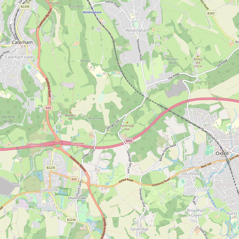
Woldingham to Oxted walk
Close to London, this walk combines stretches of both The North Downs Way, and the Greensand Way.

1010300024
Autumn on the North Downs Way
Oct-10 • Sean O'Neill
banner, swcwalk2, swcwalks 5533976197612646802 P

1010300048
Ancient yew in Tandridge churchyard
Oct-10 • Sean O'Neill
swcwalk2, swcwalk277, swcwalks, walkicon 5533976894366783618 P

CIMG0315
St Mary's chapel, Church Town
Nov-11 • Sean O'Neill
swcwalk2, swcwalks, walkicon 5675726117406655282 P
CIMG4238
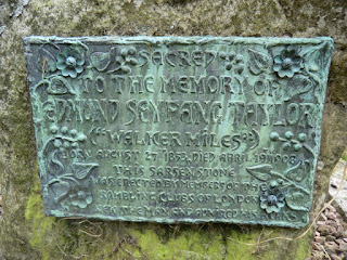
Memorial to "Walker Miles", St Nicholas' churchyard
Aug-14 • Sean O'Neill
swcwalk2, swcwalks, walkicon 6048263674910920210 P

CIMG8028
Bridleway to South Hawke
May-15 • Sean O'Neill
swcwalk2, swcwalks, walkicon 6147574323914834706 P

| Length |
Main Walk: 16¾ km (10.4 miles). Four hours 10 minutes walking time. For the whole excursion including trains, sights and meals, allow at least 8 hours. Short Walk, omitting Godstone: 11½ km (7.1 miles). Two hours 50 minutes walking time. |
|---|---|
| OS Map |
Explorer 146. Woldingham, map reference TQ359563, is in Surrey, 2 km S of Warlingham. |
| Toughness |
5 out of 10 (3 for the Short Walk). |
| Features |
This walk is only just outside the London boundary and yet the first part through Marden Park and a steady climb up the side of the valley into Marden Park Woods feels completely rural. In these woods the route joins the North Downs Way and heads west on an undulating stretch, still mostly through woodland. This section ends at a fine viewpoint on Gravelly Hill, a good picnic spot if you can put up with the incessant grumbling from the M25 below. The walk then descends from the North Downs ridge into the attractive village of Godstone, which features a large green and a good choice of places for lunch. The afternoon route mostly follows the Greensand Way, heading east from Godstone to Oxted. This section is quite different in character: a more open landscape dotted with small settlements, including one with a magnificent ancient tree in its churchyard, the Tandridge Yew. In wet weather the chalk paths in the first half of the walk can be slippery. There are also some potentially muddy stretches throughout the walk, especially on the alternative afternoon route via Broadham Green. |
| Walk Options |
There are alternative routes for both the start and finish of the Main Walk, allowing you to do a slightly longer or shorter walk respectively. In addition, the directions include two short cuts which reduce it by up to 2½ km. Directions are also given for a Short Walk. This takes the alternative morning route to South Hawke and then descends immediately from the ridge into Old Oxted, omitting Godstone. The Main Walk's two afternoon routes then make up an (optional) afternoon loop out to Tandridge. |
| Additional Notes |
The start of the Main Walk was changed in 2015 to include a new permissive path between the two parts of Marden Park Woods, reducing the stretch along the North Downs Way overlooking the M25. The original route via South Hawke was retained as the ‘alternative morning’. Some changes were also made to the Short Walk in 2018. A new permissive path through Great Church Wood was included, and the direction of the Tandridge loop was reversed to take advantage of a newly-refurbished lunch pub (see below). |
| Transport |
There is a half-hourly service from Victoria to Woldingham, taking 35 minutes. Buy a return to Oxted, which is one stop further down the line. In addition to the Victoria trains Oxted has a faster hourly service (Mon–Sat) to London Bridge. There are several useful Metrobus routes from Godstone Green if you want to finish the Main Walk after lunch. The 400 runs to Caterham and Redhill (hourly Mon–Sat; two-hourly Sun & BH), the 409 runs to Caterham (hourly Mon–Sat, plus two services on Sun) and the 410 runs hourly to Oxted and Redhill. If driving, Woldingham station car park costs around £6.50 Mon–Sat, £3 Sun (2024). At weekends parking space is also available in Church Road. Oxted station car park is free after 10am, but might be full on weekdays. |
| Suggested Train |
Take the train nearest to 09:50 from Victoria to Woldingham for the Main Walk. If you take the next one, you could do the short cut mentioned in §A to catch up a group on the earlier train. For the Short Walk, take the train nearest to 10:20. |
| Train Times |
|
| Timetables |
|
| Lunch |
The Main Walk route passes Godstone Vineyard (01883-744590) and at weekends you could detour to its cafeteria for mid-morning refreshments. The suggested place to stop for lunch is Godstone (after 9½ km on the main route), which has three pubs around its large village green. The Hare & Hounds (01883-742296) serves typical pub food; the more up-market alternatives are the White Hart (01883-742521) and the Bell Inn (01883-743216). Light lunches are also available at Blossoms Brunch & Coffee (01883-818330) opposite the Hare & Hounds, and on weekdays at the Old Forge Deli Café (01883-743230; closed Sat & Sun) near the White Hart. There are several more pubs before you reach Oxted, although these are more conveniently placed for the Short Walk. This goes through Old Oxted after 5½ km, another village with three pubs close together on its short High Street: the Chef & Brewer Old Bell (01883-712181), the George Inn (01883-713453; closed Mon & Tue) and its sister pub opposite, the Crown Inn (01883-717853; also closed Mon & Tue). A little further on, however, the suggested lunch place on this variation is The Haycutter (01883-776955) in Broadham Green, which reopened in 2017 after a long closure. A final option (requiring a short detour) is the Barley Mow (01883-713770) in Tandridge. |
| Tea |
There are several cafés and coffee shops in the main part of Oxted. Two possible tea places in Station Road West are Robertsons at #42 (01883-712777; open to 5pm Mon–Fri, 4pm Sat; closed Sun), a specialist coffee shop with a small tearoom at the back; and Café Papillon at #54 (01883-717031; nominally open to 5pm Mon–Sat but may stop serving earlier; closed Sun). There is also a conveniently placed JD Wetherspoon's pub right next to the station, the Oxted Inn (01883-723440). On the other side of the station there are more places in Station Road East, including Caffè Nero at #139 (01883-730220; open to 6pm Mon–Sat, 5pm Sun); an independent coffee shop at #85, Bru & Bear (01883-818390; open to 4pm Mon–Sat, 2pm Sun); and a Costa at #62 (01883-712866; open to 5.30pm Mon–Sat, 4.30pm Sun). |
| Profile | |
|---|---|
| Help Us! |
After the walk, please leave a comment, it really helps. Thanks! You can also upload photos to the SWC Group on Flickr (upload your photos) and videos to Youtube. This walk's tags are: |
| By Train |
Out (not a train station) Back (not a train station) |
| By Car |
Start CR3 7LT Map Directions Return to the start: Finish RH8 9EU Map Directions Travel to the start: |
| Amazon | |
| Help |
National Rail: 03457 48 49 50 • Traveline (bus times): 0871 200 22 33 (12p/min) • TFL (London) : 0343 222 1234 |
| Version |
Jun-24 Sean |
| Copyright | © Saturday Walkers Club. All Rights Reserved. No commercial use. No copying. No derivatives. Free with attribution for one time non-commercial use only. www.walkingclub.org.uk/site/license.shtml |

Walk Directions
Click the heading below to show/hide the walk route for the selected option(s).


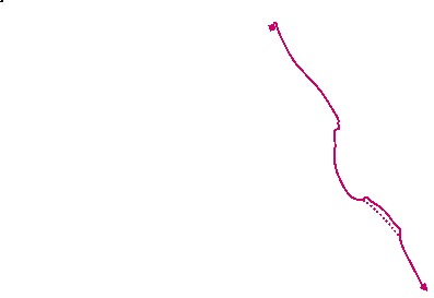

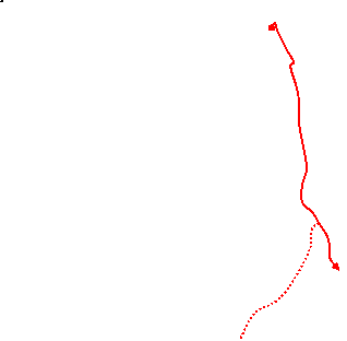 Walk Map
©
Walk Options ( Main | Short )
Click on any option to show only the sections making up that route, or the heading above to show all sections.
- Main Walk (16¾ km)
Walk Directions
Click on any section heading to switch between detailed directions and an outline, or the heading above to switch all sections.
If you are doing the Short Walk (or the alternative morning route on the Main Walk), start at §C.
- Woldingham Station to Marden Park Woods (2½ km)
- Leave through the station car park and turn sharp right onto Church Road, heading south-east. In 500m turn right at Church Road Farm onto a bridleway going over the railway and past Marden Park Farm to Woldingham School. After passing the school keep ahead on a footpath up the side of a field leading into Marden Park Woods.
- Leave the station through the entrance to its car park but do not go out onto the main road. Instead, turn sharp right up Church Road, passing an information panel “Valleys and Views” for the Woldingham Countryside Walk? (WCW), with a map of Marden Park?. Go along this lane for 500m to Church Road Farm, with fields up to your left and the railway in a cutting on your right.
- Just before the farm buildings, with a WCW signpost on the left, turn right onto a bridge across the railway. The track bends left past some modern cottages to reach Marden Park Farm. Keep ahead past the farm buildings, ignoring footpaths off to both sides. This bridleway now goes S between hedges for 1 km, rising gently above the valley on your right.
-
Ignore a path off to the left signposted to South Hawke and continue downhill through a wooded area. At the bottom you pass the buildings of Woldingham School on the right and a small cemetery on the left. Where the driveway veers down to the right there is a metal kissing gate in the wire fence ahead.
- You could choose to stay on the driveway, turning left through the school gates at the bottom of the slope and going all the way out along the drive. If you take this short cut (saving 1½ km), turn right onto the North Downs Way when you reach South Lodge and continue the directions at §E.
- For the main route go through this kissing gate, signposted as the WCW Short Cut. Follow a grassy path climbing steadily up the left-hand side of an open valley. At the top keep left and go through a wooden kissing gate into Marden Park Woods?.
- Marden Park Woods to South Lodge (2¼ km)
- Take the main path through the wood towards its south-west corner. Turn right to go back down into the wood and continue on a permissive path through Chaldons Farm into the other part of Marden Park Woods. Join the North Downs Way (NDW) to reach South Lodge.
- Take the main path through the wood for 400m, initially heading SE before curving left and coming to a major path junction. Ignore a path off to the left and take the broad path ahead (slightly to the right), briefly joining a waymarked route with red-banded posts.
-
You pass a large marl? pit down to the right, one of many in this wood. In 150m ignore a path on the left signposted to the car park, leaving the waymarked route (and the WCW). The path bends slightly right to head S and in 200m reaches a wooden vehicle barrier in front of a lane.
- At this point you could switch to the alternative route along the North Downs Way, bypassing the permissive path through Chaldons Farm. The NDW comes in from much the same direction along the lane and then forks left at the road junction outside the woodland exit. If you do switch routes, resume the directions at [?] in §D.
- For the main route do not go out onto the lane but instead turn right onto a broad path going down the slope. Keep left at a little triangle of paths to head NW through the wood, gently downhill. In 150m the path swings left and you go through a gap in a wooden barrier onto a waymarked permissive path through Chaldons Farm, which you will be following for the next 600m.
- In about 200m the woodland path bends left and climbs a slope, heading roughly S and soon with a more open area visible off to the left. After a similar distance veer right in front of a wooden fieldgate and follow the path back downhill again. At the edge of the wood the path swings left, then finally turns right into a small open area dotted with trees at the head of a valley.
- Continue alongside a low hedge, with distant views of the London skyline off to the right. On the far side go through a wooden barrier into another part of Marden Park Woods and bear right onto a broad path. In about 200m the path merges with the North Downs Way? coming in from the left.
- Continue through the wood on the NDW, alongside some magnificent beech trees. In 250m the path emerges from the wood at a clearing with a bench and views of Godstone and Tilburstow Hill. It then drops steeply downhill to leave Marden Park at South Lodge, with a track merging from the left and a school driveway coming in from the right (the short cut mentioned in §A).
- Woldingham Station to South Hawke (3 km)
- … Go along this lane and then a track for just over 1 km. Turn right onto a footpath, which goes over the railway tunnel and up through a wood. At the top turn left at a T-junction. At the next junction you could fork right to head directly for South Hawke on a bridleway, but the suggested route is to take a parallel path through Great Church Wood for the first part of this stretch. The bridleway leads into a small car park on Gangers Hill.
- …
- Keep ahead past the farm buildings onto an unsurfaced lane. In 300m keep ahead at a four-way footpath signpost. In a further 300m, as indicated by a WCW signpost on the left, veer right down a few steps and go through a metal kissing gate onto a path between fences. This heads slightly away from the lane and then zig-zags right and left over the entrance to a railway tunnel.
-
Follow the path S for 600m as it climbs steadily through a mossy wood. At the top turn left at a T-junction marked by a three-way signpost. In 100m you come to another signposted path junction. The suggested route is to fork left uphill and then immediately turn right onto a path into a Local Nature Reserve, Great Church Wood?.
- Alternatively you could fork right onto the bridleway and follow it all the way to the car park at South Hawke (the original route).
- On the suggested route follow the meandering woodland path through Great Church Wood, heading SE and with occasional glimpses of the bridleway down to your right. In 400m another path merges from the left and you go down a flight of steps cut into the bank to rejoin the original route. Turn left and follow the bridleway for 500m, climbing gently and with views across a valley on the right, ending at a small car park.
- South Hawke to South Lodge (2¼ km)
- Cross Gangers Hill and turn right onto the North Downs Way (NDW). Follow it past a viewpoint on Oxted Downs, then briefly rejoin the lane. Fork left into Tandridge Hill Lane and take a footpath alongside it downhill and round to the right, then back uphill. Cross Gangers Hill again and go through a wood to a clearing, then steeply downhill to South Lodge.
-
Leave the car park and cross the lane (Gangers Hill) carefully. Go down a short flight of steps just off to the right and turn right onto the North Downs Way? (NDW), heading SW. After 150m there is a bench at the top of Oxted Downs from which to admire a fine view of the Greensand Hills behind Oxted and Limpsfield.
The prominent redbrick building on the hillside opposite used to be St Michael's school; it closed in 2002 and is now a block of luxury apartments.
- For the Main Walk continue along the NDW. In 75m follow the main path round to the right and uphill, ignoring a bridleway ahead into the woods. The path turns left to run alongside Gangers Hill. At the end ignore signposted footpaths off to both sides and continue along the lane for 75m to a junction.
- Fork left briefly onto the single-track road (Tandridge Hill Lane) going downhill and take the signposted footpath on its right-hand side. Follow this path downhill, slightly above and away from the road. Eventually the path descends a few steps and continues alongside the lane for a short distance. Go through a metal kissing gate and bear right onto the signposted bridleway into Hanging Wood.
- The bridleway climbs gradually, with a small field on the right, then meets a lane (Gangers Hill again). Cross over the lane, go up a few steps opposite and through a wooden barrier onto a clear woodland path, heading NW. In 250m keep left where another path merges from the right.
- …
- South Lodge to Gravelly Hill (2¼ km)
- Head west on the NDW, with the option of a detour via Godstone Vineyard. Cross the A22 and continue through a wood to the viewpoint at Gravelly Hill.
- Head W along the NDW (which the main route follows all the way to Gravelly Hill). The track bends left and right, then passes a vineyard? and some cottages on the left. At the end of the fence on your left the NDW turns left, as indicated by a four-way footpath signpost.
-
Main route
- Turn left to stay on the NDW. The path goes down steps alongside the fence and curves right to meet a lane (the continuation of the track you were on). Cross over onto the footpath opposite, going up a few steps and following the potentially muddy path as it curves left and then right. 200m from the lane the path drops down to merge with a sunken byway from the left.
-
Detour via Godstone Vineyard (+1¼ km)
- Keep ahead at the signpost and follow the lane downhill and round to the left, passing a large storage facility. In 350m the lane merges with a byway from the right (your return route). On reaching a fishing lake turn left for the vineyard, which is a further 300m along this access road.
- Afterwards, retrace your steps down the access road and turn right. In 125m fork left onto the byway, rejoining the main route from a path on the right after 300m.
- Go along the byway for 150m. Soon after open fields appear on the right, turn left and cross a field to a footbridge over the A22. Go across it and turn left into a wood, following the NDW sign.
- The path twists round to the right and then climbs a short flight of steps where you turn left at the top. Soon there is another flight of steps and again you turn left at the top. The path now straightens out and heads SW for 400m.
- Eventually the path bends right and goes up a short slope. In 200m bear left to come out onto an open patch of ground alongside Gravelly Hill road, with a fine view towards the South Downs.
- Gravelly Hill to Godstone (2½ km)
-
 Continue on the NDW, bearing left onto a path going downhill through an avenue of trees. Leave the NDW by forking left twice, which leads to a farm road going over the M25. On the other side, go past the Orpheus Centre and take the second footpath on the left. Go across a field, through trees and past some disused reservoirs into Godstone.
- Continue W alongside the road, taking either of two paths half-left into the trees at the end of the open ground (they soon merge). This becomes an attractive bridleway going gently downhill between yew trees.
- After 400m fork left (leaving the NDW), now going more steeply downhill. In a further 100m bear left at another bridleway junction, still descending. At the bottom turn left onto a farm road in front of the M25.
- Follow the road round to the right and over the motorway, then past the Orpheus Centre?. Ignore a footpath on the left 50m after these buildings, but in a further 75m go through a kissing gate on the left at a second footpath sign. Turn half-right and follow a grassy path heading SE across a meadow.
-
On the far side go through the tree boundary and cross a works access road. Ignore a new permissive path off to the left and go over a stile onto a rather gloomy path between fences, with plenty of forbidding notices to discourage access to the disused reservoirs on both sides.
- The path eventually emerges into a meadow and heads towards some houses. Leave the meadow through a gate and turn right to reach Godstone?, with the Hare & Hounds pub on the left.
-
For the other possible lunch stops (or to continue the walk) cross the A25 carefully and head SE on the edge of the large village green, passing one or two cafés on the other side of the main road. The route continues on a path to the right of the White Hart, on the B2236 opposite the village pond; the Bell Inn is a little further along this road.
- Godstone to Tandridge (3 km)
- Leave Godstone on a path to the right of the White Hart, which goes past Bay Pond and comes out onto Church Lane. Go through the churchyard onto a path which winds past Glebe Water and eventually up to a large field. Turn right and follow the path round to the left past some past old stables. Turn right to go between Leigh Place Ponds, then zig-zag left and right past Leigh Mill House to meet the Greensand Way (GW). Turn left and follow the GW up to and across the A22, then across farmland for nearly 1 km to Tandridge Lane. Turn right briefly onto the road and continue on the GW around the back of the Barley Mow.
-
Leave Godstone by a tarmac path heading E to the right of the White Hart, signposted to the Parish Church. You pass to the right of White Hart Barn, then the large Bay Pond? comes into view on the left. The path eventually reaches Church Lane, opposite St Nicholas' church?.
- A short detour to the right would take you to the attractive mock-Tudor St Mary's almshouses; the houses are private but the beautiful little chapel (on your left as you go in) is usually open to the public.
-
Enter the churchyard and pass to the right of the church. The path bears right and goes gently downhill.
- Off to the left of the churchyard path you might like to see if you can find a sarsen stone? memorial of interest to walkers.
- Leave the churchyard and continue in the same direction along a narrow path which bends around Glebe Water. At the end of the pond the path turns right and then curves left in front of a strange avenue of tightly-packed conifers. Follow the sandy path uphill alongside a hedge and then round to the right, passing some pens for farm animals.
- On reaching an open field, turn right and go down the side of the field, heading S. Bear right past a gate with a redundant stile to leave the field, joining a bridleway coming in from the right. Follow this track round to the left in front of some converted stables.
- Shortly after skirting around a wooden fieldgate, turn right at a footpath sign and go through a new wooden kissing gate. The path goes down a slope and continues between Leigh Place Ponds, although the larger pond is now screened behind a high wooden fence. At the end of the smaller pond turn left through a new wooden gate.
-
Follow this public footpath between the pond and the garden of Leigh Mill House. At the far end of the pond turn right to go past the side of the property and down to a T-junction. Turn left onto the Greensand Way? (GW).
- If the path along the water's edge is closed you can carry on past Leigh Mill House and then turn sharp left (almost doubling back) onto the GW, rejoining the main route after crossing the outflow from the pond.
- Follow this fenced path gently uphill, heading E. At the top of the rise veer right to go down a few steps and continue through a wooden kissing gate to the A22. Cross this busy road with great care and continue through farmland on the GW for 900m, at first gently uphill and then across a dip where you go through a gap in some trees.
- The path eventually passes a plaque for the Queen's Green Canopy? and comes out between houses onto Tandridge Lane. Cross the road and turn right to go past the Barley Mow. Turn left onto a footpath (imaginatively named The Walk) going past its side entrance. The path swings left to go past the back of its beer garden and in 100m comes to a Y-junction, with a narrow path branching off to their right.
- Tandridge to Old Oxted (2¼ km)
- Fork left (leaving the GW) to return to Tandridge Lane and go up to St Peter's church. Follow the path through the churchyard, past its ancient yew tree and back out onto Tandridge Lane. Take a footpath on the right which leads up to and across a golf course. On the far side turn right onto a tarmac path above the A25 and continue along the old Godstone Road into Old Oxted.
- Fork left at the Y-junction, staying on the main path and leaving the GW. Keep to the left of a driveway and follow the footpath gently uphill between houses and gardens. At the top turn right onto Tandridge Lane. Keep right at a minor road junction and continue across two driveways to come to the tarmac path leading to the church.
- Go up the path and through the lychgate into the churchyard. As you approach St Peter's church? (which is usually locked) you pass the magnificent Tandridge Yew?.
- Turn left between this ancient tree and the church to rejoin Tandridge Lane, then almost immediately bear right onto a footpath through a copse. At the end of the trees, cross a driveway and go through an old kissing gate into a field. Follow the grassy path uphill to another gate, which leads you onto a golf course.
- The path heads NE, slightly downhill through trees. At the end of the trees keep ahead across a fairway, aiming just to the left of a house. Take the tarmac drive which starts alongside the house and follow it all the way through the golf course, taking care as you cross more fairways near the end.
- After leaving the course and crossing its access road, turn right onto a tarmac path above the A25. The path descends and later curves away from the main road, following the course of the old Godstone Road. A slip road from the A25 joins from the left and you continue to a crossroads in the centre of Old Oxted, with the Old Bell opposite and two more pubs ahead if you want to break for refreshment.
- Old Oxted to Oxted Station (2 • 1 km)
-
 For the full walk, leave Old Oxted by heading south on Beadles Lane. Turn left into Springfield and take a footpath to the right of a driveway which curves round to the right. At the end turn left onto Spring Lane.
Go past Oxted Mill and take a footpath on the left across a meadow to Woodhurst Lane. Turn left along the road, then in 100m turn half-left onto an enclosed footpath. Go across the A25 and down East Hill Road to a roundabout. Turn right and go along Station Road West to the station.
For the full walk, leave Old Oxted by heading south on Beadles Lane. Turn left into Springfield and take a footpath to the right of a driveway which curves round to the right. At the end turn left onto Spring Lane.
Go past Oxted Mill and take a footpath on the left across a meadow to Woodhurst Lane. Turn left along the road, then in 100m turn half-left onto an enclosed footpath. Go across the A25 and down East Hill Road to a roundabout. Turn right and go along Station Road West to the station.
-
For a direct route to the station, go down Old Oxted's High Street and follow Church Lane to Station Road West.
-
For a direct route to the station, go down Old Oxted's High Street and follow Church Lane to Station Road West.
-
Main route (2 km)
- From the crossroads head S on Beadles Lane for 200m, then turn left into Springfield?. Where this street bends left keep ahead on a signposted footpath, briefly along a driveway and then a narrow fenced path to its right. This soon curves round to the right, later with a stream on the left. Follow the path past a mill pond to Spring Lane, with the converted Oxted Mill ahead on your left.
-
Go past Oxted Mill to the sluice-gate at the end of the mill pond and take the signposted footpath on the left, through a new wooden kissing gate into an overgrown meadow. Follow the grassy path heading NE, later with gardens and a stream off to the left. Cross the stream at a weir and go up a driveway to a road (Woodhurst Lane).
- Turn left and go along the road for 100m. At its junction with Woodhurst Park turn half-left onto a tarmac path between fences, which climbs steadily and in 200m comes out onto the A25. Cross this busy road with great care and go straight ahead down East Hill Road. Turn right at a roundabout into Station Road West.
-
Short cut (1 km)
- From the crossroads head E down the High Street, soon passing the George Inn and the Crown Inn. Just before the last house on the left turn left onto a tarmac path leading to an underpass.
- After going under the A25 follow the path to a road junction and turn left into Church Lane, signposted to the station and town centre. In 600m keep ahead at a roundabout into Station Road West.
-
The station is at the end of this road, 225m away. There are two possible tea places towards the end of the parade of shops on the right: Robertsons and Café Papillon. The Oxted Inn is on the right of the station entrance.
-
You could also take the pedestrian tunnel under the station and go through a small parking area into Station Road East: Caffè Nero is on the left; a Costa and several other refreshment places are down the road to the right.
-
You could also take the pedestrian tunnel under the station and go through a small parking area into Station Road East: Caffè Nero is on the left; a Costa and several other refreshment places are down the road to the right.
- South Hawke to Barrow Green Road (1½ km)
- Cross Gangers Hill and turn right onto the North Downs Way (NDW) to come to a viewpoint on Oxted Downs. Go through a gate on the left and follow a footpath down the left edge of a field, then slanting down to the right. Head for a footbridge over the M25 and continue along a bridleway to Barrow Green Road.
- …
- Go through a gate with a yellow waymarker near the left-hand end of the fence at the viewpoint. Follow a grassy path down through the field, initially near its left-hand edge and then slanting steeply down to the right. At the bottom go through a metal kissing gate and continue on a broad grassy strip between fields. Go over a stile beside a metal fieldgate, joining a bridleway coming in from the right.
- Cross the M25 footbridge and continue on the bridleway for 750m, with numerous “Private Property” signs and CCTV cameras to dissuade you from straying off the right of way. Towards the end you pass the buildings of Barrow Green Court behind a high security fence on the left, and farm buildings on the right where the path meets Barrow Green Road.
- Barrow Green Road to Oxted Mill (1¾ km)
- Go across a field past The Mount and Townland Pond and turn right at the end onto Sandy Lane. Keep ahead at the crossroads in Old Oxted to continue on Beadles Lane. Turn left into Springfield and take a footpath to the right of a driveway which curves round to the right to reach Spring Lane.
-
Cross Barrow Green Road carefully and squeeze through an inconspicuous metal gate in the hedge opposite onto a footpath between wire fences, still heading SE. On your right you pass The Mount (a small hill) and later the tree-lined Townland Pond. At the end turn right onto Sandy Lane and head S along it for 200m, passing under the A25 and going up to a crossroads in Old Oxted.
- The full Short Walk returns here after looping through Broadham Green and Tandridge (which also have pubs), but if you want to break for refreshment now there are three pubs within 100m on the left: the Old Bell, the George Inn and the Crown Inn.
- …
- Oxted Mill to Tandridge Lane (2½ km)
- Join the Greensand Way (GW) and follow it south to The Haycutter on Tanhouse Road. Turn right and go alongside the road to Broadham Green. Cut across the green on the left to continue on the GW, heading west. On the outskirts of Tandridge the most direct route is to stay on the bridleway as it curves right up a slope to Tandridge Lane, but you could also detour into the village to visit the Barley Mow. Go up to St Peter's church at the top of the village.
- Go straight across Spring Lane onto a driveway, joining the Greensand Way? (GW). This veers right and left past garages and continues alongside Mill House End's garden. After passing the house go through a metal kissing gate and follow the path across three fields, negotiating some potentially muddy areas around the gates between them. The path comes out onto Tanhouse Road opposite The Haycutter pub, the suggested lunch stop.
- The walk continues on the broad grassy strip alongside Tanhouse Road (ie. turn left if coming out of the pub). Where this opens out onto a small triangular green, bear left to cut across it. On the far side cross Broadham Green Road and continue on the signposted bridleway near the 40mph road signs, heading W through a gap between the houses alongside the green.
-
In 200m keep ahead at a crossing, now on tarmac driveway. In a further 200m keep left where the drive swings right into some private properties. The track climbs gently and then goes steadily downhill, with occasional views across the Eden Valley through the trees on the left.
If this sunken bridleway is too muddy you could try walking along the bank, although a barbed wire fence now makes this more awkward than it used to be.
- At the bottom of the slope the path goes under a low bridge and continues between hedges, with a meadow on the left. In 150m there is a gate into the meadow which is the continuation of the GW.
-
Main route
- Stay on the bridleway, leaving the GW. The track curves right and climbs steadily, soon becoming a tarmac driveway. After going past a few buildings it curves left to come out onto a minor road (Tandridge Lane) at the top of the village. Turn right onto the road and cross another driveway to come to the tarmac path leading to the church.
-
Route via the Barley Mow (+500m)
- For the pub turn left through the gate and follow a grassy path sloping up to the right. At the brow of the hill keep right and go up to a metal kissing gate in the corner. Go through this onto a short sunken path through a belt of trees, which turns left and merges with a broad path from the right.
- You soon pass the beer garden of the Barley Mow on the right and the path swings round to its side entrance. After visiting the pub retrace your steps past its beer garden as far as the path junction where you came down from the right.
- …
- Tandridge Lane to Oxted Station (2¾ km)
-
…
Go down the High Street, crossing over your outward route. At the bottom cross the A25 via an underpass and continue along Church Lane and Station Road West to the station.
- …
- …
- …
- …
- …
- …
- …
- Tandridge to Oxted Mill (2½ km)
- Fork right, staying on the GW. Follow the path into a meadow and down to meet a track coming in from the left. Turn right and head east along this bridleway for about 1¼ km to reach Broadham Green Road. Cross the road and cut across the green on the left to continue along Tanhouse Road to The Haycutter. Opposite the pub take a footpath heading north across fields to Spring Lane.
-
At the junction fork right, staying on the GW. The narrow path soon turns right to go up through a belt of trees. Go out through a metal kissing gate into a meadow and follow a grassy path straight ahead, then down a slope to the left. At the bottom go through an old gate and turn right onto a bridleway. Head E along this track for 800m, soon climbing gently and with occasional views across the Eden Valley through the trees.
…
- Eventually you join a tarmac driveway going gently downhill, then in 200m go straight across the driveway to Oxted Place. After a further potentially muddy 200m you come out between houses onto a green. Go up to Broadham Green Road.
- Cross the road and turn half-left to go across a small triangular green. In the far corner bear right to go alongside Tanhouse Road on a broad grassy strip. In 150m you come to The Haycutter pub on the right, a possible refreshment stop.
- Cross the road opposite the pub and go through a wooden kissing gate onto a grassy path heading roughly N across three fields, negotiating some potentially muddy areas around the gates between them. At the end of the last field go through another gate and continue between a house and stables to come out onto Spring Lane, with the converted Oxted Mill on the right.
- Oxted Mill to the Station (1¼ km)
-
…
- …
- …
- …
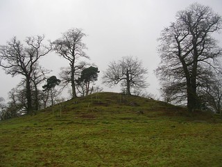
- The Woldingham Countryside Walk essentially follows the triangular route defined by Woldingham station, South Hawke and South Lodge.
- Marden Park and its estate were built up by Sir Robert Clayton, Lord Mayor of London in 1679-80. The original house was replaced in 1879 and the buildings at the centre of the estate are now Woldingham School.
- Marden Park Woods are split into two sites on the North Downs ridge, linked by a permissive path around the back of Chaldons Farm. The woods are owned and managed by the Woodland Trust.
- Marl is a mixture of clay and limestone, formerly added to sandy soils to improve their fertility.
- The North Downs Way runs for 246 km along the length of the North Downs (with two sections at its eastern end), from Farnham in Surrey to Dover in Kent.
- Now part of Marden Park Woods, Great Church Wood was once owned by Sir Adrian Boult, the conductor.
- Godstone Vineyard produces a sparkling wine from Seyval Blanc and Bacchus grapes.
- The Orpheus Centre is a performing arts centre for young disabled adults, founded in 1998 by Richard Stilgoe.
- Even William Cobbett (normally a stern critic) acknowledged in his classic Rural Rides that Godstone was “a beautiful village”. He was less complimentary of its neighbour, Bletchingley: “happily for Godstone, out of sight”.
- Bay Pond used to provide the water power for a large gunpowder factory in the 17thC. It is now managed as a Nature Reserve by the Surrey Wildlife Trust.
- St Nicholas, Godstone dates from the 13thC, replacing an earlier Norman church. The north aisle was added in 1845 and the whole church was restored by Sir George Gilbert Scott in 1872-3. He also designed the mock-Tudor St Mary's almshouses alongside St Nicholas.
- The sarsen stone commemorates Edmund Seyfang Taylor (1853-1908), who under the name Walker Miles wrote and published a series of “Field-Path Rambles”: pocket-sized walking guides for Surrey and Kent which were known for their meticulous attention to detail. He was a founding member of the Federation of Rambling Clubs, which in 1935 became the Ramblers Association.
- The Greensand Way runs for 175 km from Haslemere in Surrey to Hamstreet in Kent, following the course of a sandstone ridge just to the south of the North Downs.
- The Queen's Green Canopy plaque commemorates an avenue of 70 young trees planted for Her Majesty's Platinum Jubilee in 2022, each sponsored by a local family.
- St Peter, Tandridge dates from the early 12thC. It was restored by Sir George Gilbert Scott in the 19thC; there is a marble tomb-monument in the churchyard to his wife (Lady Scott) who died in 1872. The church contains a reproduction of the famous Ghent Altarpiece by the van Eyck brothers.
- The Tandridge Yew is a female tree which still produces berries. It is exceptionally tall and has a girth of 11 metres. Judging by its measured rate of growth it is at least 1,000 years old; some sources speculate that it is much older. There is a yew tree of a similar age in the village of Crowhurst, 4 km south of Tandridge.
- The Springfield housing development is on the site of Oxted's Old School, as shown by the “Oxtead National Schools 1872” inscription preserved on the stone wall.
Some of the minor paths through this Open Access Wood have been closed to prevent the spread of Ash Dieback, but the suggested route is on main paths and unlikely to be affected.
Continue the directions at §E.
If you are doing the Short Walk (omitting Godstone), go to §J.
If you want to visit Godstone Vineyard (which has a cafeteria), follow the detour in [?].
If you are doing the alternative afternoon route (via Broadham Green), go to §N.
The main route to the station loops past Oxted Mill on Spring Lane, but if you are in a hurry you could take the short cut along roads in [?].
If you are not doing the Tandridge loop, complete the directions at §O.
If you want to visit the Barley Mow, follow the directions in [?].
Walk Notes
» Last updated: June 25, 2024
Return to Top | Walk Map | Walk Options | Walk Directions.