| Length |
Standard walk 20.5km (12.7 miles). Time: 6 hours 30 minutes. For the whole outing, including trains, sights and meals, allow at least 12 hours. For a shorter walk and other variations, see below
|
| Features |
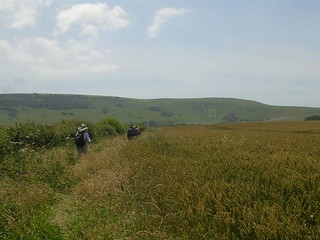
This South Downs walk heads from inland Sussex to the coast, taking in a variety of scenery along the way. From Berwick the walk cuts across to the peaceful birdwatchers’ paradise of Arlington Reservoir before crossing farmland towards Wilmington, then ascends to the huge chalk figure of the Long Man. From here the route continues to the historic smuggling village of Jevington, then ascends the South Downs to follow ridges of chalk grassland with views in all directions, before descending to the seaside resort of Eastbourne and the possibility of extending the walk to the dramatic heights of Beachy Head.
Note that this walk involves one busy road crossing (A27) at Wilmington.
|
| Walk Options |
Directions for these variations are given at the end of the main walk text.
- a) Short walk to Polegate via Folkington: You can reduce the length of this walk by finishing at Polegate. To go via Folkington, a walk of 11.6km (7.2 miles), follow the main walk directions until point [5], then pick up the alternative directions at the end of the main walk text. Note that the last 1.6km (1 mile) of this option is on suburban roads.
- b) Long walk via Beachy Head You can lengthen the walk to visit Beachy Head by following the South Downs Way all the way to the coast. This creates a walk of 24.6km (15.3 miles). Follow the main walk directions until just before point [9], then pick up the long walk directions where indicated at the end of the main walk text.
- Bus options to shorten the walks. It is also possible to shorten the walk by 4.3km (2.7 miles) by taking the 12/12A bus from the A259, just before [8] to Eastbourne station. This bus runs as often as every 12 minutes during the day, and half hourly until late in the evening. There is also a bus to Eastbourne station from Beachy Head - the 13X - which saves 5km (3.1 miles) off option b) Long walk via Beachy Head. This bus runs on Sundays and public holidays throughout the year; on Saturday, Sundays and public holidays from late March to late June; and daily from late June to late September. For detailed times for both buses, call 01273 886200 or consult the website www.buses.co.uk .
| Ancient or modern?
|
The Long Man of Wilmington is one of those ancient chalk figures that may not in fact be that ancient. Certainly if you get up close to it you will see that it is not a chalk-cut figure at all, but white stones, cemented together. These date from 1874, and before that, the figure was only visible in certain lights.
The earliest known drawing of the figure dates from 1766, but in that the Long Man is holding a rake and a scythe, not the long poles it now has. How much earlier than that the figure was created, no one knows.
Whoever did create the figure understood perspective – it is elongated so that it looks in proportion when viewed from below. It is also special in depicting a human at all – though there are several white horses dotted around the country, the only other human chalk cut figure in England is the Cerne Abbas giant near Dorchester.
|
| History |
Arlington Reservoir was constructed in 1971 as demand for water increased. This 120-acre site is a designated site of Specific Scientific Interest and a local nature reserve.
On its 30th anniversary Bill Oddie opened a waymarked pathway around the perimeter called 'The Osprey Nature Trail'.
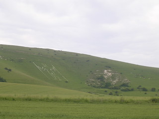
Wilmington Here the famous 226 foot chalk figure of the Long Man of Wilmington towers above the village on the side of Windover Hill. It is unknown what this male figure carved into the chalk bearing two long staves represents, but theories include that he may be a fertility symbol, an ancient warrior, or just an 18th century folly.
Jevington In the 1780s this was a renowned area for smuggling organised by James Pettit, known as 'Jevington Jigg', the local innkeeper and leader of a local gang. His activities were well documented in reports and newspaper accounts at the time. He stored his contraband in the inn which is now the Eight Bells, the suggested lunch stop for this walk. In 1788 an attempt to arrest Jigg was made by a party of armed constables as he played cards inside the inn. He escaped by quickly donning women's clothes, dashing outside, and feigning hysterics. The constables were too slow to react and he made his escape by horse. He shortly returned, but this time was captured after being discovered hiding in the loft. After various adventures he was convicted of horse stealing in 1799 and sentenced to 14 years at Botany Bay.
Filching Manor and the Motor Museum, Jevington (tel 01323 487838) on the short cut via Jevington houses a private collection of veteran and vintage cars. It is open to visitors from 10.30am to 4.30pm Thursday to Sunday from Easter to October. Admission is £3.50 for adults and £2.50 for concessions.
Beachy Head This famous landmark is the highest chalk sea cliff in Britain, rising164 metres above the English Channel at a location indicated by its distinctive red and white striped unmanned lighthouse.
|
| Travel
|
Hourly trains go from London Victoria to Berwick, changing at Lewes (journey time: 1 hour 33 minutes). On Sundays trains are via Brighton (journey time: 1 hour 41 minutes). Trains back from Eastbourne are approximately twice hourly (journey time average 1 hour 29 minutes, some trains are direct, others change at Haywards Heath, 10-20 minutes slower on Sunday). Buy a day return ticket to Eastbourne. For those driving, the best place to park is Berwick station; trains back from Eastbourne take 14 minutes, and are hourly.
Suggested train : Take the train nearest to 9am from Victoria Station to Berwick.
By car: There is a car park (fee payable) at Berwick Station.
|
| Lunch and Tea
|
Long Man Inn Wilmington, BN26 5SQ (01323 368525) Situted 4.9km (3 miles) into the walk, this welcoming pub has an interesting and inventive menu, and is the suggested lunch stop for the walk.
Eight Bells High Street, Jevington, BN26 5QB (01323 484442) This is a very popular pub and gets quite crowed, but has a reasonably sized garden. Situated 10.8km (6.7 miles) into the walk, it is a possible late lunch stop.
Jevington Tea Garden Jevington, BN26 5QJ (01323 489692) Set in the garden of a private house (with some inside tables) this pleasant tearoom is just 200 metres up the road from the Eight Bells.
Beachy Head Beachy Head Road, BN20 7YA (01323 728060) This pub, right on Beachy Head itself, is a good tea option. It serves meals, and tea and coffee all afternoon and evening, and offers views back over the walk from its windows.
Qualisea Fish Restaurant 189 Terminus Road Eastbourne BN21 3DH (01323 725203) This pleasant, sit-down fish and chip restaurant has long been a post-walk favourite with Saturday Walkers.
| |