Lewes Circular via Glynde and Southease walk
An energetic walk over 3 separate hills in the South Downs NP with great views throughout.

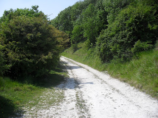
First section (anticlockwise)
Lewes Circular walk
Jun-15 • Saturdaywalker on Flickr
swcwalk65 swcwalks swcwalk47 walkicon 18424175039
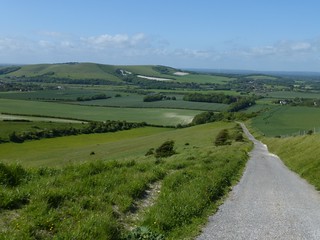
Descending to Glynde (anticlockwise)
Lewes Circular walk
Jun-15 • Saturdaywalker on Flickr
walkicon swcwalks swcwalk47 18422665250


| Length |
Main walk 23.6km (14.6 miles) Lewes to Glynde (part 1) 6.2km (3.8 miles) Glynde to Southease (part 2) 6.3km (3.9 miles) Southease to Lewes (part 3) 11.1km (6.9 miles) |
|---|---|
| Toughness | 7 out of 10 (three steep climbs, but mostly easy level walking on good paths with easy navigation) |
| Maps | OS Explorer OL11 (was 122) Brighton |
| Features |
This is an energetic walk (550 metres or 1,600 feet of ascent) over three distinct downland ridges, with magnificent views throughout. One of the pleasures of the walk is that the entire route is in view for much of the walk, so you can look back at the terrain you have already done or ahead to the delights to come. Navigation is easy, the walking is over wide and distinct paths, and while there are three substantial climbs, most of the walk is flat, gently undulating or downhill. As well as plenty of grand downland walking, the route includes a start and finish in historic Lewes, quaint corners of which you see both at the start and end of the walk, an optional detour to Mount Caburn (Iron Age fort) with its dramatic viewpoint of the whole circuit, and the pleasant small village of Glynde. You also pass the remote station of Southease, with its YHA cafe nearby. There walk passes 3 train stations, one between each of the 3 hills, so if you want to drop out, its quite easy. You can do the walk either clockwise or anticlockwise, and directions are given for both in the attached pdf |
| Walk Options |
Directions are given to do this walk anti-clockwise (Lewes-Southease-Glynde-Lewes) or clockwise (Lewes-Glynde-Southease-Lewes). There is not much to choose between them in terms of views or gradients climbed: rather it is the length of sections and the positioning of lunch and tea options: Anti-clockwise (directions on pages 3-5 of the pdf) is in many ways better. It has the advantage that you get the long Lewes to Southease section out of the way first, and this provides a decent length section before you get to lunch at the Abergavenny Arms in Rodmell. Doing the Lewes to Southease section in this direction also means you have a long pleasant descent with fine views to Rodmell, and also, in section two, to Glynde. In the afternoon, the Little Cottage Tea Rooms in Glynde (if they are open) are a possible tea stop, though sadly there is no longer a pub stop in the village. You then have an exhilarating finish over Mount Caburn that brings you directly down into the part of Lewes with the best tea options (Cliffe High Street). If tired, you can omit this last section and still enjoy a 17.4km (10.8 mile walk).. Clockwise (directions on pages 6-9 of the pdf) leaves the longest section, Lewes to Southease, till last, and you face a long slow climb up to the highest point on the walk as part of this. If you feel too tired to tackle this, you have to finish the walk at Southease, after just 12.5km (7.7 miles). There is also a long slow climb out of Glynde. Now that the Trevor Arms in Glynde has closed, the only lunch option in that village is the Little Cottage Tea Rooms, if they are open. After that, the next refreshment is at the YHA Cafe in Southease after 12.3km (7.6 miles), while the only possible pub lunch is in Rodmell, after 14.5km (9 miles). You can also obviously do the circular walk starting in Glynde or Southease, though if doing the latter by train, note that, the YHA cafe excepted, there are no pubs or facilities at this station, and only a basic shelter on its platform Shorter walk options: As there is a station at the start and end of each section of this walk, you can do any one section as a walk in its own right, or any two consecutive ones (even starting at Southease, lunching in Lewes and finishing in Glynde or vice versa). If you are planning to walk from Lewes to Southease clockwise, however, you may like to consider the Lewes via West Firle walk (Walk 25 in Time Out Country Walks Volume Two), which covers some extra territory not included on this route. Longer walk options: Heroic types might like to substitute the directions for the Lewes via West Firle walk on this website for the clockwise section two of this walk from Glynde to Southease, taking in a longer downland section and the pretty village of West Firle with its possible lunch stop at the Ram Inn. To do this, follow the directions in this document as far as the end of clockwise section one and then follow the Lewes via West Firle directions from point [3]. At Southease carry on with clockwise section 3 of this walk. This adds 6.3km (4 miles) to the walk, making a total walk length of 29.9km (18.6 miles). |
| Transport |
Trains to Lewes go twice hourly from Victoria (hourly on Sundays). The train recommended train is the one closest to 9.45am, but if doing the clockwise walk and aiming to lunch at Glynde the first train after 10am is fine, and if aiming to lunch in Rodmell in this direction the 9.15am might be a good idea. To start at Glynde or Southease (hourly trains in either case), change at Lewes. Connections are usually better for the Southease trains than the Glynde ones. A day return to these stations is valid for return via Lewes. By car: Start in Glynde (BN8 6RU), Kingston near Lewes (around BN7 3LA, closest to London and A27), or Rodmell (BN7 3EZ, pub), all of which have free parking. |
| Lunch/Tea |
The Trevor Arms, the pub in Glynde has sadly now closed. The Little Cottage Tea Rooms, 01273 858215, next to the post office in Glynde, serves cream teas in a pleasant garden from 11am to 4pm Thursday to Sunday most of the year, but only at weekends in January and February. In the Easter, late May and summer school holidays it is open daily except Wednesday. Glynde Stores and Post Office next door to the tea room serves takeaway coffee and hot chocolate (but not tea!) until 2pm Wednesday, 4pm Saturday and 3pm other days. The YHA Courtyard Cafe near Southease station is open till 8.30pm daily serving burgers, pizzas, salads, jacket potatoes, toasties, hot drinks and cakes. The Abergavenny Arms, Rodmell, 01273 472416, is a popular pub with a pleasant outdoor terrace and is now the only possible lunch pub on this walk. It is open 12pm to 10pm daily and serves food all afternoon until 8.30pm (8pm Sunday). Where you have tea in Lewes will probably depend on which direction you are doing the walk in. On the anti-clockwise walk the pedestrianised Cliffe High Street is the first bit of the town you come to, and has several cafes and eating places as as well some fine old pubs. On the clockwise walk a short diversion off the walk route as you approach Lewes would take you to the charming Juggs Inn in the village of Kingston. Otherwise the road leading up the hill from the station may have one or two independent cafes (they seem to come and go...), while a back stop option is a Caffe Nero in the High Street open until 6pm daily. In both directions the Landsdown Arms is a characterful pub near the station, and The Runaway, the cafe on platform 2 of Lewes station, is recommended for its excellent range of cakes and inside seating: it is open until 6.50pm Monday to Friday, 5.50pm Saturday and 5.20pm Sunday. |
| Profile | |
|---|---|
| Help Us! |
After the walk, please leave a comment, it really helps. Thanks! You can also upload photos to the SWC Group on Flickr (upload your photos) and videos to Youtube. This walk's tags are: |
| By Train |
Out (not a train station) Back (not a train station) |
| By Car |
Start BN7 2UP Map Directions |
| Amazon | |
| Help |
National Rail: 03457 48 49 50 • Traveline (bus times): 0871 200 22 33 (12p/min) • TFL (London) : 0343 222 1234 |
| Version | |
| Copyright | © Saturday Walkers Club. All Rights Reserved. No commercial use. No copying. No derivatives. Free with attribution for one time non-commercial use only. www.walkingclub.org.uk/site/license.shtml |


Walk Directions
Full directions for this walk are in a PDF file (link above) which you can print, or download on to a Kindle, tablet, or smartphone.
The directions below are just an outline for use with a map.
This is just the introduction. This walk's detailed directions are in a PDF available from wwww.walkingclub.org.uk
The following are brief notes for someone with an OS map, or familiar with the area. Its also possible to follow the route using TOCW Book 2, but printing the map would help, especially the 'in reverse' bit.
Clockwise
By Book: Follow the start of Book 2, Walk 25, as far as Glynde Station (Points [1] to [3] in the instructions)
- [Map 1A] Turn right out of the station.
- Then right on to the main shopping street and continue (downhill).
- Straight on across the bridge, and straight on up the steep hill to the Golf Club clubhouse (CH on the map).
- Leave the road to the right of the clubhouse
- [Map 1B] Circuit around the bowl you can see in front of you. In more detail: contour north around the bottom of the golf course, then east following the ridge via Saxon Down, then south to an intersection of paths just to the north of Coombe Hill. (The TOCW2 Walk 25 route goes straight through the middle of the bowl, rather than around it)
- To visit Cliffe Hill: The summit trig point, 164m (not really worth it), a Marilyn, is hidden among the golf course trees. There is a badly waymarked path to it. At the northernmost point of the 'bowl' loop, head back west along a path along the top of the ridge
- From the intersection of paths, the short detour to Mount Caburn at the south end of the ridge (less than 100m) is well worth the view.
- Head east, steeply downhill, to Glynde (village shop).
- Then south along the road, past the train station.
By Book: Follow Book 2, Walk 25, as far as Southease Station (Points [3] to [6] in the instructions). This is the longer (via West Firle option). The suggested route takes 2 shortcuts. You should be able to follow the brief instructions below (basically, straight on, then turn right at the top of the hill).
- [Map 2A] Continue south along the road, past the recommended Trevor Arms pub.
- Continue south along the road, cross a busy road, and continue south on a lane for 30 metres. (This is a shortcut from the route walk 25 takes)
- Here you have a choice.
- To take option 1 (via West Firle): (this is the book route) Turn east, pass Preston Manor, then south along a road, then southeast at the junction to West Firle, pass the Ram Inn and continue through the village and up onto the downs. Once on the ridge, turn right, sharply back on yourself and follow (due west) the SDW, rejoining the main route by the carpark.
- The main route is to follow the minor road up to the top of the ridge to a small car park, and turn right (west)
- [Map 2B] Follow the South Downs Way (SDW) west. At the end of the ridge, follow it downhill, cross the road via a foorbridge, and carry on to Southease Station.
By Book: Follow Walk 26 to point [2] in the Abergavenny Arms pub in Rodmell. This is the longer option. You should be able to follow the shorter option using the brief instructions below. Then follow Walk 24, points [5] to [1] in reverse, to Lewes. The notes below should help.
- [Map 3A] Head west from Southease Station, and cross the bridge. here you have a choice.
- To take Option 2 (the new SDW route): Head north along the river, then west across the fields to Rodmell.
- The shorter route is to follow the old SDW route. Continue along the road, through Southease (a small village with a large church), then north along a signposted permissive path (parallel to the main road) to Rodmell and the Abergavenny Arms
- Head south west, along a minor road opposite the pub up to the ridge.
- [Map 3B] Follow the SDW north west along the ridge (with a big drop on your right hand side)
- When the ridge turns due west, you turn north east, steeply downhill towards towards Kingston in Lewes.
- Continue on this path all the way to Lewes.
- [Map 3C] Cross a minor road, and later a bridge high over a motorway.
- The path becomes Juggs road which joins Priory Street, follow it (east)
- The road curves north to the station, just past it is the The Lansdown Arms.
Anticlockwise
Lewes to Southease
By Book : Walk 24, [1] to [5] (Rodmell) then walk 26 [2] to [3]
- Left out of the station, right on Priory Street, join Judd Lane, straight on (cross over the motorway, then a small road), and continue up to the ridge
- Follow the ridge southeast
- Turn left onto a quiet lane steeply downhill to the Abergavenny Arms pub in Rodmell
- After the pub, either, (shorter, old SDW route) follow the signposted permissive path south (parallel to the main road), then turn left through Southease village to the station (past a big church), or take option 2 (follow the longer but prettier new SDW route towards the river, then south to the bridge, cross it for the station)
Southease to Glynde
By book : Walk 26 [3] to [4], then follow walk 25 in reverse from [6] to [3].
- Continue east, cross the road, and up onto the downs along the SDW
- At the path junction by the carpark, head north downhill along a quiet lane
- or take Option 1 : continue east along the ridge, then sharply back on yourself, northwest to West Firle. Pass the Ram Inn, heading NW then N, and turn west towards a farm at the entrance of Firle Manor, then join a quiet lane [the main route] heading north to the main road)
- Cross the busy road, and continue north, past the Trevor Arms to Glynde Station
Glynde to Lewes
By book: Walk 25, [3] to [1] in reverse.
- Turn left at the village shop, cross the style and up on to the downs
- At the ridge, first detour 200m south to Mount Caburn, retrace your steps, then skirt north around the 'bowl' shaped valley in front of you.
- Skirt below the golf course, cross the style just after the clubhouse
- Down the lane to Lewes, cross the bridge, along the high street
- Left to the station, passing the Landsdown Arms on your way