Whyteleafe to Hayes Walk
Fields, woods and quiet valleys in a surprisingly rural part of south London.


| Length |
Main Walk: 16¾ km (10.4 miles). Four hours walking time. For the whole excursion including trains, sights and meals, allow at least 7½ hours. Alternative Start, from New Addington: 14¼ km (8.8 miles). Three hours 20 minutes walking time. Short Walk, finishing at New Addington: 10¾ km (6.7 miles). Two hours 35 minutes walking time. Short Circular Walk, from New Addington: 8¼ km (5.1 miles). One hour 55 minutes walking time. |
|---|---|
| OS Maps |
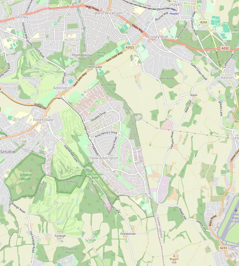
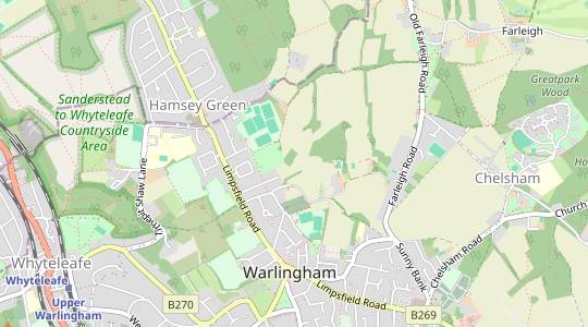
Explorers 146, 147, 161 & 162. Whyteleafe, map reference TQ338585, is on the London / Surrey border, 8 km S of Croydon. Hayes is in the London Borough of Bromley. |
| Toughness |
4 out of 10 (3 for the Alternative Start, 2 for the Short Walks). |
| Features |
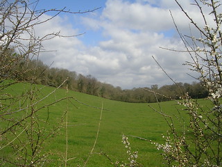
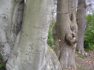
The first half of this walk is never far from the London / Surrey border and the second half is entirely within the London Borough of Bromley, but it is surprisingly rural in character. You are soon out of the commuter belt and passing along shady footpaths and bridleways with plenty of fine vistas across this gently rolling countryside. Although there are few noteworthy features, the afternoon route runs parallel to the main runway at Biggin Hill Airport (1½ km away) so this would be an interesting walk to do when it is hosting an Air Show. |
| Walk Options |
Directions are given for an Alternative Start from New Addington, which is 2½ km shorter than the Main Walk. If your travel was disrupted you could alight at East Croydon, take a tram from outside the station to New Addington and expect to catch up the main group at the lunch pub. A different link route is also described for a Short Walk finishing at New Addington, which is 6 km shorter than the Main Walk. These two options can be combined to make a Short Circular Walk. The directions also include an alternative ending across Hayes Common with a safer crossing of a busy main road. |
| Transport |
The most convenient starting point for this walk is the rather misleadingly named Upper Warlingham station (see Walk Notes), which is close to Whyteleafe station in the valley below Warlingham. The stations (in TfL Zone 6) are on different lines but both go through East Croydon. Upper Warlingham has a half-hourly service from Victoria, taking 32 minutes; Whyteleafe has a half-hourly service from London Bridge, taking 37 minutes. Hayes (in TfL Zone 5; shown as “Hayes (Kent)” on ticket machines) is the terminus of the mid-Kent line, with a half-hourly service to London Bridge and Charing Cross. New Addington is the terminus of one of the Croydon Tramlink lines and the directions for the shorter walk options are to or from this point. Trams run every 7-8 minutes (15 minutes on Sun & BH) from West Croydon station (journey time 25 minutes) and East Croydon (20 minutes). New Addington is also well served by buses and there are several other bus routes near the start and finish of the Main Walk, but you would need to call a taxi if you wanted to finish at the lunch pub. None of the walk options are convenient for car drivers as there are no direct public transport links between the various start and finish points. The most convenient interchange point is Croydon, using London bus 119 to connect from Hayes. |
| Suggested Train |
Take the train nearest to 10:15 from Victoria to Upper Warlingham (or from London Bridge to Whyteleafe). For the Alternative Start take a New Addington tram from East or West Croydon station at around 11am. |
| Train Times |
|
| Timetables |
|
| Lunch |
The most conveniently placed pub is in the tiny hamlet of Fickleshole (7¼ km from Whyteleafe; 4¾ km from New Addington). The White Bear (01883-779384) is an attractive oak-timbered pub, formed from a small terrace of 16thC cottages. It has been extensively modernised and is now a large and efficient country pub which serves food all day from noon, with a number of small rooms and alcoves for dining inside as well as plenty of outside tables in its large patio and garden. An earlier pub which is closer to the midpoint of the Short Walk (but only a quarter of the way through the Main Walk) is The Harrow (01883-627565) on the edge of Great Farleigh Green, reached via a short detour off the main route. |
| Tea |
There are three convenient refreshment places in the road directly opposite Hayes station: the New Inn (020–8462 2865) is a large bar / restaurant (with a “smart casual attire” dress code); the Real Ale Way (07446-897885) is a family-owned micropub, open daily from 2pm; and there is a Costa coffee shop, open to 6pm Mon–Sat, 5.30pm Sun. A little further along the road there are two more places open Mon–Sat, but both are likely to be closed at the end of a walk: Sponge Kitchens is a bakery with a coffee shop open to 3.30pm; Café Hayes is open to 3pm. If you finish at New Addington there are several cafés and fast food places along the broad Central Parade leading away from the tram stop, including a Costa coffee shop, a Starburger café / restaurant and Cafe Dino. |
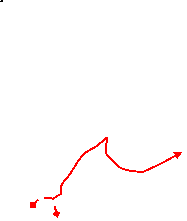
| Profile | |
|---|---|
| Help Us! |
After the walk, please leave a comment, it really helps. Thanks! You can also upload photos to the SWC Group on Flickr (upload your photos) and videos to Youtube. This walk's tags are: |
| By Train |
Out (not a train station) Back (not a train station) |
| By Car |
Start Map Directions Return to the start: Finish Map Directions Travel to the start: |
| Amazon | |
| Help |
National Rail: 03457 48 49 50 • Traveline (bus times): 0871 200 22 33 (12p/min) • TFL (London) : 0343 222 1234 |
| Version |
Apr-25 Chris L |
| Copyright | © Saturday Walkers Club. All Rights Reserved. No commercial use. No copying. No derivatives. Free with attribution for one time non-commercial use only. www.walkingclub.org.uk/site/license.shtml |


Walk Directions
Click the heading below to show/hide the walk route for the selected option(s).


 Walk Maps
©
Walk Options
Click on any option to show only the sections making up that route, or the heading above to show all sections.
- Main Walk (16¾ km)
If you are doing the Alternative Start or the Short Circular Walk (from New Addington), start at §D.
Walk Directions
Click on any section heading to switch between detailed directions and an outline, or the heading above to switch all sections.
- Whyteleafe to Limpsfield Road (2 km)
- From either Upper Warlingham or Whyteleafe station, head for the Recreation Ground in Hillbury Road. Turn half-right and take a path going steeply uphill. At the top turn right onto Tithepit Shaw Lane, then bear left onto a side road. Turn left onto a bridleway leading to Limpsfield Road.
-
Starting from Upper? Warlingham Station
- Arriving from London, go up the steps in the middle of the platform and turn right on the footbridge to come out onto Westhall Road. Turn left, go down to the bottom of the hill and turn right into Hillbury Road. In 80m turn left into Whyteleafe Recreation Ground.
-
Starting from Whyteleafe Station
- Leave the station by a path at the front of the platform and turn sharp left. Go across the roundabout on the A22 (there is a pedestrian crossing off to the left), up the B270 (Hillbury Road) and under the railway bridge. In 100m turn left into Whyteleafe Recreation Ground.
- Go through the car park and turn half-right across the grass, passing the park café and then some tennis courts on your right. Continue in the same direction on a clear path which bends right and climbs a long flight of steps through a lightly wooded area, the southern end of the Sanderstead to Whyteleafe Countryside Area? (SWCA).
- At the top keep ahead through a clearing. On the far side go through a kissing gate and turn right onto a road (Tithepit Shaw Lane), leaving the SWCA. In 125m cross the road and take the access road for the Hillbury Farm development, which stays fairly close to the main road as they both start to descend.
- In 200m turn left onto a signposted bridleway, initially through woodland and then between fields and a new housing development. In 350m the path comes out onto the B269 (Limpsfield Road).
- Limpsfield Road to Greatpark (2¾ km)
-
Cross Limpsfield Road to continue on Crewe's Lane. Turn left onto an alleyway leading to Hamsey Green Recreation Ground. Go diagonally across it and continue on a footpath between a sports ground and a field. At Kingsmead Equestrian Centre join a bridleway going across a valley to Old Farleigh Road. Keep ahead across Great Farleigh Green and through the northern tip of Littlepark Wood. Veer right to continue along the bottom edge of a large field. At a five-way path junction take the footpath heading east between Greatpark Wood and the Greatpark estate.
- To detour to the earlier lunch pub, turn right after crossing Old Farleigh Road to reach The Harrow at the southern end of Great Farleigh Green. Return to the main route via a bridleway heading east to the five-way path junction.
- Cross the main road carefully and continue on the residential street opposite, Crewe's Lane. In 175m, shortly before the road bends right, turn left past metal barriers onto an alleyway between houses. Follow this for 150m (crossing a street in the middle) into a corner of Hamsey Green Recreation Ground, which you will be leaving to the left of a children's play area in the opposite corner.
- You might be able to cut across the grass to this corner, but if there are games taking place the right of way is a tree-lined path around two sides of the ground. In the corner bear left onto a narrow and potentially muddy enclosed footpath between a sports ground and an open field.
- In 300m the path goes past the side of some riding stables. Ignore its access road off to the left and take either the bridleway straight ahead or (if too muddy) a parallel footpath a few paces to its left. If you take the footpath it turns sharp left after 125m, at which point you would need to switch back to the bridleway.
- Follow this tree-lined bridleway as it heads E for a further 1 km, halfway along descending into an open valley and climbing back up the other side. Eventually it comes out onto Old Farleigh Road, running along the western edge of Great Farleigh Green.
-
Main route
- Cross the road and go straight across the common for 150m, still heading E and aiming just to the right of a house. On the far side take a waymarked footpath bearing slightly right into Littlepark Wood.
-
At a Y-junction the simplest route is to fork left to go down to the bottom of the wood, then turn right to go along the edge of a large field.
- A slightly nicer route is to fork right at the Y-junction and take a meandering path through this open-access wood. There are several connecting paths out to the large field on your left and at some point in the next 250m you would need to take one of these to continue in the same direction outside the wood.
- On the field-edge path bear left about 100m before the end of the field, on a clear grassy path which cuts off a corner and leads to a wooden kissing gate in the tree boundary.
- Go through the gate and turn left onto a bridleway at a signposted five-way path junction, then immediately turn right onto a footpath heading E.
-
Route via The Harrow (+200m)
- Cross the road and turn right onto a permissive horse ride running parallel to the road. In 300m it goes through some undergrowth and comes out by a mini-roundabout, with The Harrow inn across the main road.
- After visiting the pub make your way back across the mini-roundabout and take the signposted bridleway heading ESE, a potentially muddy fenced path between Littlepark Wood and the houses on Harrow Road.
- In 300m go straight across a small clearing, passing a white-painted Coal Tax post? in the undergrowth on the left and going gently downhill.
- In 200m the tree-lined bridleway comes to a signposted five-way path junction. Ignore the first footpath off to the right but turn right onto the second, heading E.
- Greatpark to Fickleshole (2½ km)
- At the end of the Greatpark estate follow the path round to the right through the wood. Turn left at a footpath T-junction and merge with a bridleway leading to Farleigh Court Road. Turn right onto the lane, then in 100m turn left onto a bridleway (High Hill Road) going through a strip of woodland and across a valley to Fairchildes Road. Turn left onto the road to reach the White Bear in Fickleshole.
- The footpath goes along the southern edge of Greatpark Wood. After it swings left and the high wooden fence on the right changes to a wooden rail fence the Greatpark estate comes into view. Opposite its prominent Clock Tower? you pass a locked metal gate into the wood, with a plaque listing the previous uses of the site.
- After passing the last of the buildings the footpath continues through woodland and soon turns half-right, staying fairly close to the estate's boundary fence. In 200m you pass a redundant stile and come to a T-junction in front of a field. Turn left and follow the path as it swings left and right, merging with a bridleway from the right.
- In 250m the tree-lined bridleway comes out onto a lane (Farleigh Court Road) where you turn right, following the sign for Cycle Route 21 (CR 21) towards Greenwich and New Addington. In 100m turn left through a metal gate onto the continuation of CR 21, a bridleway (named High Hill Road on the OS map) through a narrow strip of woodland.
- In 500m the bridleway descends into a valley and climbs steeply up the other side. At the top go through a metal fieldgate and continue past stables to a road (Fairchildes Road). Turn left onto the road, taking care as there is no pavement and more traffic than you might expect.
- After passing the entrance to Fickleshole Farm the road bends right and you come to the White Bear on the left-hand side of the road. The doors at the front of the pub are now fire exits so you need to go around the right-hand side of the building to its entrance at the back.
- New Addington to Little Farleigh Green (2¾ km)
- From the Tramlink terminus head west across a strip of grassland. Take a footpath to the left of the recycling centre on North Downs Road and fork left at a path junction into Hutchinson's Bank. Cut through the first of the enclosures on Slimming's Down onto a path leading down to Featherbed Lane opposite Frylands Wood Scout Outdoor Centre. Take the public footpath through its grounds and then southwards to Little Farleigh Green.
- From the Croydon end of the tram platform, turn left and cross the road (Parkway) onto a strip of grassland. Go past a menagerie of animal sculptures and take the tarmac path signposted to North Downs Road along the left-hand side of the green.
- At the far end turn left onto the road, then in 40m turn right onto a tarmac footpath next to the entrance to Fishers Farm Recycling Centre, passing an information panel about the butterflies on Hutchinson's Bank?. In 100m fork left at a path junction by a metal sign for this nature reserve.
-
The path curves round to the left and you go through a metal kissing gate to enter the reserve. In 150m turn right through a gap in the trees onto an easily-missed narrow path, going down a few steps and through a wooden kissing gate onto Slimming's Down.
- If sheep or goats are grazing in this enclosure the gate is likely to be locked. In this case carry on down the narrow path and turn left at the bottom onto a concrete track (the continuation of Farleigh Dean Crescent). In 100m turn right through a gap in the trees onto another narrow path and resume the directions at [?].
- Inside the enclosure follow a grassy path along the top of the open downland, with fine views across the valley. In 50m ignore a faint path down to a wooden gate in the tree boundary, but in a further 75m turn right by a wooden bench to go down the slope to a second gate. Go through this and straight across a concrete track onto a narrow path through the trees.
- Follow the path down a few steps and go straight across a wide grassy horse ride onto a clear path through a semi-open area, with wooden fieldgates at both ends. Carry on through another wooden gate in the tree boundary ahead to a road (Featherbed Lane). Cross the road carefully onto a track into Frylands Wood Scout Outdoor Centre, signposted as a public footpath to Little Farleigh Green.
- You now simply follow this well-signposted right of way up through the woodland, starting by turning right uphill and then curving round to the left. The broad path climbs steadily near the right-hand edge of the wood for 700m before swinging round to the left to head E. In a further 200m turn right at a signposted path junction to leave the Scout Centre grounds.
- The right of way continues as a narrow woodland path for 250m, winding its way through the trees before emerging into the corner of a large field. Keep ahead along its left-hand edge, heading S.
- In 450m, shortly before the end of the field, bear left through a wide gap in the tree boundary. Go over a stile onto a path which goes along the right-hand edge of a small clearing, then curves right and emerges into a small open area. Go past a row of cottages on the right to a footpath signpost on Little Farleigh Green.
- Little Farleigh Green to Fickleshole (2 • 1 km)
-
For the main route take the footpath heading south-west from the green, crossing Farleigh Court Road and a couple of fields. Turn left onto a bridleway (joining the Main Walk route) going back across Farleigh Court Road and continuing along a track (High Hill Road). Turn left onto Fairchildes Road to reach the White Bear in Fickleshole.
- For a short cut, take the footpath heading east from Little Farleigh Green to join High Hill Road halfway between Farleigh Court Road and Fairchildes Road.
-
Main route (2 km)
- Keep right at the signpost. Ignore a grassy path straight ahead and go across the green to its right, aiming for a gap in the trees ahead, to reach a lane opposite a small parking area. Cross the lane (Farleigh Court Road) and continue on a grassy path from the back of the car park.
- The path goes through a lightly wooded area for 75m and emerges into a field. Bear left to go across it to the field corner, 100m away. Bear left through a gap and follow a grassy path across an area of scrubland, heading S. On the far side go through a gap in the tree boundary and turn left onto a tree-lined bridleway.
- In 200m the bridleway comes out onto a lane (Farleigh Court Road again) …
- In 500m …
-
Short cut (1 km)
- Turn left at the signpost and follow a faint grassy path across a lightly wooded area. In 150m go past a white-painted Coal Tax post? and straight across a field, heading ESE. On the far side go over a stile and turn left onto a woodland bridleway.
- In 100m …
- …
- Fickleshole to Skid Hill Lane (¾ km)
- Carry on briefly along Fairchildes Road, past its junction with Featherbed Lane. Bear left onto a footpath going past the entrance to Fairchildes Farm, through two paddocks and across a field. In the field corner bear right to go between two more fields and keep ahead on a cycleway leading to Skid Hill Lane.
- From the pub return to Fairchildes Road and turn left, towards its junction with Featherbed Lane. Keep ahead briefly (now on Park Road), then bear left up a driveway to Fairchildes Farm, temporarily leaving Cycle Route 21. Go straight across another driveway coming in from the road onto a track, signposted as a footpath.
- Go over a stile to the left of the entrance to Fairchildes Paw Park (for dog training). At the end of a fenced grassy path cross a stile on the left and turn half-left from your previous direction to go across two paddocks, with another stile in the fence between them.
- On the far side cross two more stiles and carry on in much the same direction across a large field, passing to the right of two large oak trees. In the field corner bear right to continue along what was once a tree-lined avenue but is now just a broad grassy track between tree stumps.
- At the end squeeze through a gap beside a vehicle barrier and swerve left and right to rejoin CR 21 along what used to be the continuation of Park Road but is now a cycleway. In 175m there is a misleading CR 21 sign pointing left along a woodland path, shortly before the cycleway meets a road (Skid Hill Lane).
- Skid Hill Lane to Blackness Lane (3¼ km)
- Cross the road and take the bridleway opposite across a field and through Jewels Wood. After crossing a road by the entrance to Higham's Hill Farm simply continue along the bridleway as it heads north and later north-east for over 2½ km, eventually coming out onto Blackness Lane.
- Cross the road ahead and take the bridleway opposite, signposted to Keston. Follow the track past a few buildings and then between fields for 250m to enter Jewels Wood. Inside the wood fork left at a Y-junction to continue through the wood, heading NE.
- Near the end of the wood keep left to emerge onto a road (Sheepbarn Lane / Jewels Hill). Cross the road and go down the track to the right of the entrance to Highams Hill Farm. In 225m ignore a footpath off to the right and carry on along the shady bridleway, gently downhill with fine views over the open valley to the right.
- In 900m go past a stile on the right, joining the Leaves Green Circular Walk? (LGCW) coming in from this footpath. Fork right at the Y-junction ahead, staying on the bridleway as it starts to climb gently through a wood.
- You now simply carry on along the bridleway for a further 1½ km, ignoring cross paths (at one of which there are distant views of the London skyline away to the left). Eventually the path descends slightly and emerges onto a track with cottages on the right. Follow this out to a minor road (Blackness Lane).
- Blackness Lane to Gates Green Road (3½ km)
- Turn left onto the lane, then left again onto Jackass Lane at a T-junction. In 250m turn left onto a footpath leading to the hamlet of Nash, following the waymarked Nash Circular Walk (NCW). Turn right briefly onto Nash Lane, then left onto North Pole Road. In 150m turn right onto a footpath leading to Well Wood. Follow the NCW through the wood to the Rouse Farm exit and then along a bridleway to Gates Green Road. Turn right and go along the road for 175m, where there is a footpath off to the left.
- Turn left onto Blackness Lane, which soon comes to a T-junction. Turn left again (onto Jackass Lane), leaving the LGCW but joining the Nash Circular Walk? (NCW) coming in from Church Road.
- In 250m turn left off the lane onto a footpath signposted to Nash. This enclosed path bends right and descends for 600m between fields. Eventually the path turns right to go along the bottom of a long shallow valley, with a field on the left.
- In 350m follow the path round two left turns and uphill to double back along the top of the field. At a T-junction with a farm track turn right to climb up the side of the valley, away from a gate into the field. In 200m you pass a horse exercise yard and then stables on the left.
- At the end of the track go over a stile on the left. Follow a fenced path past the entrance to Fortune Bank Farm and out to a minor road in the hamlet of Nash, with Nash Cottage on the right. Turn right briefly onto this road (Nash Lane), then immediately turn left onto North Pole Lane.
- In 150m turn right onto a signposted footpath, going over a stile and up a fenced path betwen fields. At the top turn right at a four-way path junction to continue along the right-hand edge of a field. In the corner you pass a redundant stile and immediately turn left, going past a wooden barrier into Well Wood.
- Inside the wood fork left at the first junction, staying on the NCW. The path runs near the edge of the wood briefly before curving round to the right. Fork right at the next junction to continue on a long straight path heading NNW through the wood, with good displays of wood anemones in spring.
- In 225m the path comes to a triangular path-junction where you turn right, still on the NCW. Ignore a path to the left and another to the right to continue along the edge of the wood, curving gently round to the left. In 150m keep ahead alongside a garden fence to emerge from the wood at the end of a residential street (Queensway).
- Bear slightly right and take the signposted bridleway opposite. Follow this enclosed path gently downill for 400m, bending left and then right. At the bottom turn right onto Gates Green Road, crossing over to use the pavement. At the end of the houses on the left the road narrows and there is a footpath off to the left, signposted to Hayes.
- Gates Green Road to Hayes Station (2 • 1¾ km)
-
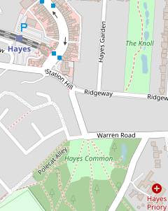 To follow the original walk route carry on along the road for 175m and turn left onto the next footpath. At the top join the driveway to Hast Hill House (leaving the NCW) and cross Baston Manor Road onto Hayes Common. Take a woodland path leading to the A232 (Croydon Road) near its junction with West Common Road. Cross the A232 and take a path heading north-west through the wooded common.
- For an alternative route, turn left onto the first footpath, leaving the NCW. At the top turn left and follow the LOOP (or a parallel woodland path) to Hartfield Crescent. Cross the A232 at the pedestrian lights and take a woodland path heading north through the wooded Hayes Common.
-
Original route (2 km)
- Ignore the footpath and carry on along the road for a further 175m, then turn left onto a second footpath, signposted to Hayes Common. This goes past a Pressure Reducing Station and climbs up the hillside, with views over the valley to the right and the large Hast Hill House ahead on your left.
- At the top keep ahead on the house's driveway, leaving the NCW (which veers off to the right). Go straight across a minor road (Baston Manor Road) and take the unsignposted path opposite onto the wooded Hayes Common.
- In 75m veer left to emerge at the junction of West Common Road and the busy A232 (Croydon Road). Cross Croydon Road with great care, keeping to the left of West Common Road. Go between gorse bushes and past a wooden horse barrier on a long straight path through the wooded common, heading NW.
- After 300m there are houses behind tall wooden fencing on your right. Keep right to stay on the main path, close to the edge of the woodland. In a further 450m the path comes out onto a lane (Prestons Road). Cross the lane and take the path opposite through more trees to a clearing.
-
Alternative route (1¾ km)
- Turn left onto the first footpath, leaving the NCW. Follow the path past the garden of the end house and up the hillside via a long flight of steps. At the top you come to a T-junction with a broad path, with an information panel for Hayes Common opposite.
-
Turn left onto the path, briefly joining the London Outer Orbital Path? (LOOP). After passing a wooden horse barrier the simplest route is to follow the “Hayes Station 1 mile” LOOP signpost pointing along the edge of the wooded common.
- A slightly nicer route is to fork right at the path junction by the signpost, then veer left to continue along the edge of a clearing. Follow the path into the trees to continue in much the same direction, parallel to both the broad path and the A232 (Croydon Road) which you can hear off to your right.
- In 300m both routes approach a side road (Hartfield Crescent). On the broad path veer right as signposted to leave the LOOP and merge with the woodland path. Cross the side road and then the A232 at the pedestrian lights. Go past a wooden vehicle barrier and take the broad path straight ahead through the wooded common, heading N.
- In 200m fork left at a Y-junction. The path merges with another from the right, bends left and heads NW across a small clearing to a lane (Prestons Road). Cross the lane and take the path opposite heading N through another patch of woodland for 175m before emerging in a clearing.
-
Keep ahead across the clearing to the middle of the far side. Go past an information panel by a metal barrier to leave Hayes Common, cross Warren Road and go down Station Hill opposite. Keep left at its junction with Ridgeway and turn right at the bottom onto a main road, Station Approach.
-
The New Inn, the Real Ale Way and a Costa are all on the right-hand side of Station Approach, opposite the entrance to Hayes Station. Alternatively, buses to Croydon leave from the stop outside the micropub.
-
There are also a couple of cafés beyond the station, but these are unlikely to be open after mid-afternoon.
-
There are also a couple of cafés beyond the station, but these are unlikely to be open after mid-afternoon.
- Skid Hill Lane to New Addington (2¾ km)
-
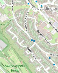 Turn left off the cycleway just before Skid Hill Lane. Follow this footpath alongside the playing fields and then the buildings of Meridian School. At the end bear left onto a path going past its entrance and also Fairchildes Primary School. After passing a nursery keep ahead alongside Fairchildes Avenue for 250m, then veer left onto a permissive path going all the way along the top of Hutchinson's Bank (or a parallel path along the top of Slimming's Down where possible). At the end follow the path round to the right into New Addington, crossing North Downs Road to come to the Tramlink terminus at the north-western end of Central Parade.
-
Turn left onto the path at the CR 21 sign. This soon straightens out to go along a strip of woodland, with a school playing field and later the school buildings on your left.
It appears that cycles used to be allowed along this path but a signpost at the far end confirms that it is now designated as a public footpath, which would explain why CR 21 has been rerouted to go along Skid Hill Lane.
- At the end of this long straight path bear left onto a tree-lined tarmac path which passes the entrances to Meridian High School and later Fairchildes Primary School. The tarmac path ends at the entrance to a nursery and you continue alongside Fairchildes Avenue on a grassy path, with a belt of trees on your left.
- In 250m, at a triangular patch of grass just before the start of houses on the left, veer left onto a signposted permissive path going gently downhill into woodland. In 100m fork right at a path junction, signposted to Hutchinson's Bank?.
- After going through a metal kissing gate into the nature reserve the path curves left and there is a choice of routes where it splits again. The left fork leads to a wooden kissing gate onto Slimming's Down, while forking right would keep you on the woodland path along the top of Hutchinson's Bank.
- There are fine views from the top of the open downland and the suggested strategy is to take this route wherever it is open (it is divided into a number of enclosures and the gates between them are likely to be padlocked where sheep or goats are grazing). There are several link paths where you can switch between the parallel downland and woodland routes.
-
The open downland ends after about 800m, just before the houses on Farleigh Dean Crescent. On this route a gate in the top corner leads onto a narrow path going up a few steps to rejoin the woodland path. In 150m this leaves the nature reserve through a metal kissing gate and curves up to the right, where it merges with a tarmac path coming up the hillside.
-
Go past a metal sign for Hutchinson's Bank and follow the path between houses and a recycling centre to North Downs Road. Turn left briefly onto the road, then veer right onto a tarmac path signposted to Overbury Crescent. This runs alongside a strip of grassland and leads to a main road (Parkway), with a stop for buses to Croydon on this side and the Tramlink terminus opposite.
-
If you want some refreshment turn right to go along a broad avenue, Central Parade. There are several cafés and fast food shops in the parade of shops on the far side (but no pubs).
-
If you want some refreshment turn right to go along a broad avenue, Central Parade. There are several cafés and fast food shops in the parade of shops on the far side (but no pubs).
- The station on the Oxted line was named ‘Upper’ Warlingham when it opened in 1884 to distinguish it from another Warlingham station, lower down the valley on the Caterham line. It retained the unnecessary prefix when the other station was renamed Whyteleafe South in 1956.
- The Sanderstead to Whyteleafe Countryside Area is jointly owned by Croydon and Tandridge Councils and the Whitgift Foundation. The three owners are working with Natural England to restore the 200 acres of chalk downland under the Countryside Stewardship Scheme.
- Cast-iron Coal Tax posts were erected in the 1860s to mark a taxation boundary. A levy on coal had been brought in to help pay for the rebuilding of London after the Great Fire of 1666, and with the growth of road and rail transport it was no longer practicable to collect it in the Port of London.
- The Clock Tower was the water tower for Warlingham Park Hospital (formerly Croydon Mental Hospital) before the site was redeveloped as the Greatpark estate. The psychiatric hospital was a pioneering centre for psychosurgery, the now discredited treatment of mental disorder by the destruction of brain tissue.
- Hutchinson's Bank Local Nature Reserve is a steep-sided valley of chalk grassland noted for its diverse range of butterflies and moths. It is owned by Croydon Council and managed by the London Wildlife Trust.
- The Leaves Green Circular Walk (LGCW) is an 11 km walk promoted by Bromley Council, skirting around Biggin Hill airport and passing Charles Darwin's house at Downe.
- The Nash Circular Walk (NCW) is a 7 km walk promoted by Bromley Council, taking in Baston Manor and Keston Windmill.
- The London Outer Orbital Path – the ‘M25 for walkers’ – runs for 240 km around outer London, from Erith in Kent to Purfleet in Essex.
The most convenient station for this walk is Upper Warlingham, but Whyteleafe station is very close.
If you want to visit the earlier lunch pub on this walk, take the alternative route in [?]
Continue the directions at §F.
If you want to go directly to the lunch pub, take the short cut in [?].
If you are doing a Short Walk (to New Addington), go to §J.
There is a choice of routes for this final section. The original route in [?] has a more rural feel but involves an awkward crossing of a busy main road. The alternative route in [?] is slightly shorter and crosses the main road safely at a set of pedestrian lights, but suffers from more road noise as it has to run parallel to it for 300m.
Walk Notes
» Last updated: April 24, 2025
Return to Top | Walk Map | Walk Options | Walk Directions.